GPS Enabled Soil Moisture Meter by ACMAS Technologies Pvt Ltd.
•
2 j'aime•476 vues

Soil moisture is commonly defined as the amount of water contained in a unit volume of soil. The retention of moisture, or water, in the soil and the attendant runoff from naturally occurring rainfall, snow melt, or irrigation are fundamental processes upon which all civilization depends for food production, potable water, and navigable streams and waterways.

Recommandé
Recommandé
Contenu connexe
Tendances
Tendances (15)
En vedette
En vedette (7)
Similaire à GPS Enabled Soil Moisture Meter by ACMAS Technologies Pvt Ltd.
Similaire à GPS Enabled Soil Moisture Meter by ACMAS Technologies Pvt Ltd. (20)
Plus de Acmas Technologies Pvt. Ltd.
Plus de Acmas Technologies Pvt. Ltd. (20)
Dernier
Dernier (20)
GPS Enabled Soil Moisture Meter by ACMAS Technologies Pvt Ltd.
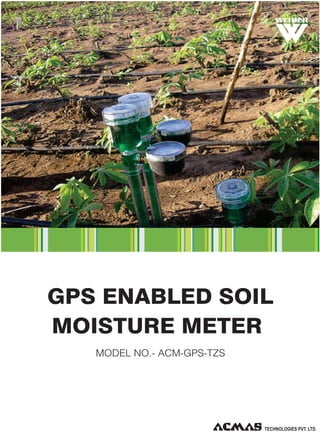
- 1. R GPS ENABLED SOIL MOISTURE METER MODEL NO.- ACM-GPS-TZS
- 2. R GPS ENABLED SOIL MOISTURE METER MODEL NO.- ACM-GPS-TZS Soil moisture is commonly defined as the amount of water contained in a unit volume of soil. The retention of moisture, or water, in the soil and the attendant runoff from naturally occurring rainfall, snow melt, or irrigation are fundamental processes upon which all civilization depends for food production, potable water, and navigable streams and waterways. But how is soil moisture linked to weather and climate prediction? Put simply, soil moisture affects the transfer of moisture (remember that water vapor is a gas and one that can transport heat) into the atmosphere. Dry soil can contribute little to no moisture; saturated and super-saturated soils can contribute lots. So much, in fact, that large land surfaces that become flooded can create their own closed-loop as the evaporated moisture forms local clouds that continue to add to the system via continuing precipitation But how can scientists get an accurate handle on soil moisture given the enormous variations in land forms and the millions of square miles of land on this planet? They do this by using atmospheric general circulation models. These models are computer-driven mathematical representations of the major variables associated with the atmosphere. Our GPS enabled soil moisture meters model helps the scientist in this application area. Our GPS enable soil moisture detectors have RS 232 C interface and dat logging system to log in all the acquired data to the parent computer for further analysis and simulation studies. This unique equipment is supplied complete with the data analysis and data print software. TECHNOLOGIES PVT. LTD.
- 3. R PRODUCT USAGE Soil moisture is an important component of the soil, crop growth; water-saving irrigation has a very important role. GPS positioning system through the control of soil moisture (moisture) in distribution, for the differentiation of water-saving irrigation to provide a scientific basis, while precision is also conducive to increased crop water yield and quality. OPERATING PRINCIPLE Our soil moister analyzer launches a certain frequency electromagnetic waves, electromagnetic waves transmitted along the probe reaches the bottom and return to detect the probe output voltage, due to changes in the dielectric constant of soil depends on soil moisture, from the relationship between output voltage and water the soil can be calculated water content. PRODUCT FEATURES Ÿ Large-screen LCD display Ÿ Membrane keys Ÿ Real-time display of water value Ÿ Group number Ÿ Light Weight Ÿ Low Voltage Warning Comes with Special Aluminum Carrying Case Ÿ RS 232 C Interface TECHNOLOGIES PVT. LTD.
- 4. R TECHNICAL PARAMETERS Water Unit % (m3/m3) Moisture content test range 0-100% Test time ≤ 2 M Sec Test absolute error ≤ 2% Relative percent error ≤ 3% Soil moisture sensor operating temperature: -10°C -- 70°C Moisture Probe Size: Stainless steel probe 80mm long; Probe Length 205mm Standard cable length 1700mm Water Storage Data 2000 Group Net Weight 1kg Power 4 5, battery TECHNOLOGIES PVT. LTD.
- 5. R TZS—TYPE Direct measurements show that the value of soil moisture content, the data storage function (2000 group), directly stored in the host TZS-I-TYPE RS-232 communication interface with the computer communications, private data download software either direct measurement of soil water scores, but also the real-time measurement of the moisture content of stored data, and can be connected with the computer data export software with storage, printing features (software free) TZS-II-TYPE With all the features of TZS I, an increase of GPS positioning capabilities. Soil moisture content in the test, while measuring point can be measured accurate information (longitude, latitude), sample points can be displayed at any time location information, and may position and moisture, group number and other information stored within the host, but also through the computer Export. Thus, to reflect the spatial differences of soil moisture. Not only facilitate the implementation of water-saving irrigation, water supply is also precisely the same time, help improve crop yields and quality. Achieved moisture content and three-dimensional location information of the automatic sampling and handling of the sensor, GPS receiver signal processing and calculates the corresponding data, with display, storage, communications and other functions, and can be in the computer analysis of water distribution . TECHNOLOGIES PVT. LTD.
- 6. An ISO 9001 : 2208 | ISO 14001 : 2008 | ISO 13485 WHO: GMP Products | GLP Compliant Products www.acmasindia.com | www.acmasglobal.com | www.measuring-meters.com TECHNOLOGIES PVT. LTD. CORPORATE OFFICE/ SHOWROOM (INDIA) Plot No. 352-353, Sector – 57 Phase- IV Kundli, Sonepat, Haryana - 131028 Land Line No.: +91 - 11- 47619688, Fax: +91-11-47619788 E-mail.: info@acmasindia.com SALES OFFICE (HONG KONG) Unit D 28 11/F Wing Tat Comm,Bidg 97, Bonham Strand East, Sheung Wan, Hong Kong (PRC) Tel.: 0086-13929598046 | 0086- 18922303099 E-mail.: hk@acmasindia.com SALES OFFICE (RUSSIA) Inmed Trade Street Ozerkovsky Embankment, Unit No 50, Straine- 1, Off- 502, Moscow, Russia E-mail.: info@acmasindia.com Tel.: 0049- 79592345 | Email: russia@acmasindia.com