
Recommandé
Contenu connexe
Similaire à Airports forecasting
Similaire à Airports forecasting (20)
Dernier
Dernier (20)
Airports forecasting
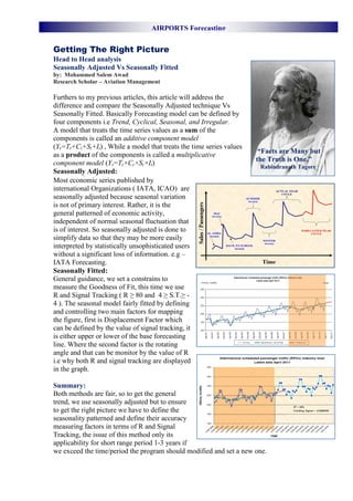
- 1. AIRPORTS Forecasting Getting The Right Picture Head to Head analysis Seasonally Adjusted Vs Seasonally Fitted by: Mohammed Salem Awad Research Scholar – Aviation Management Furthers to my previous articles, this article will address the difference and compare the Seasonally Adjusted technique Vs Seasonally Fitted. Basically Forecasting model can be defined by four components i.e Trend, Cyclical, Seasonal, and Irregular. A model that treats the time series values as a sum of the components is called an additive component model (Yt=Tt+Ct+St+It) , While a model that treats the time series values “Facts are Many but as a product of the components is called a multiplicative the Truth is One.” component model (Yt=Tt×Ct×St×It) Rabindranath Tagore Seasonally Adjusted: Most economic series published by international Organizations ( IATA, ICAO) are seasonally adjusted because seasonal variation is not of primary interest. Rather, it is the general patterned of economic activity, independent of normal seasonal fluctuation that is of interest. So seasonally adjusted is done to simplify data so that they may be more easily interpreted by statistically unsophisticated users without a significant loss of information. e.g – IATA Forecasting. Seasonally Fitted: General guidance, we set a constrains to measure the Goodness of Fit, this time we use R and Signal Tracking ( R ≥ 80 and 4 ≥ S.T.≥ - 4 ). The seasonal model fairly fitted by defining and controlling two main factors for mapping the figure, first is Displacement Factor which can be defined by the value of signal tracking, it is either upper or lower of the base forecasting line. Where the second factor is the rotating angle and that can be monitor by the value of R i.e why both R and signal tracking are displayed in the graph. Summary: Both methods are fair, so to get the general trend, we use seasonally adjusted but to ensure to get the right picture we have to define the seasonality patterned and define their accuracy measuring factors in terms of R and Signal Tracking, the issue of this method only its applicability for short range period 1-3 years if we exceed the time/period the program should modified and set a new one.
- 2. AIRPORTS Forecasting INTERNATIONALS Airports A'A Airport Airports Forecasting: Airport forecasting is an important issue in Aviation industry. It becomes an integral parts of transportation planning. It sets targets and goals for the airports, either for long term or medium term planning. The primary statistical methods used in airport aviation activity forecasting are market share approach, econometric modeling, and time series modeling. Model Used: Based on a historical data of the airports, (3 years on monthly bases) the mathematical model is developed where its fairness and goodness of fit can be defined by two important factors: R2 (Coeff. Of Determination) > 80% S. T (Signal Tracking) ..(- 4 S.T. 4) This time we try to set (S.T.) to Zero Oslo Airport, Gardermoen (Norwegian: Oslo lufthavn, Gardermoen; IATA: OSL, ICAO: ENGM), also known as Gardermoen Airport, is the principal airport serving Oslo, the capital of and most populous city in Norway. Oslo is also served by the low-cost Torp Airport and Rygge Airport. Gardermoen acts as the main domestic hub and international airport for Norway, and is the second-busiest airport in the Nordic countries. R2 = 93 % , S.T.= 0 2013(F) = 23,717,975 Pax Munich Airport (IATA: MUC, ICAO: EDDM) (German: Flughafen München), is an international airport located 28.5 km (17.7 mi) northeast of Munich, Germany, and is a hub for Lufthansa and Star Alliance partner airlines. It is located near the old city of Freising and is named in memory of the former Bavarian Prime minister Franz Josef Strauss. The airport is located on the territory of four different municipalities: Oberding (location of the terminals; district of Erding), Hallbergmoos, Freising and Marzling (district of Freising). R2 = 94 % , S.T.= 0 2013(F) = 42,565,394 Pax Paris Orly Airport (French: Aéroport de Paris- Orly) (IATA: ORY, ICAO: LFPO) is an international airport located partially in Orly and partially in Villeneuve-le-Roi, 7 NM (13 km; 8.1 mi) south of Paris, France. It has flights to cities in Europe, the Middle East, Africa, the Caribbean, North America and Southeast Asia. Prior to the construction of Charles de Gaulle Airport, Orly was the main airport of Paris. R2 = 91 % , S.T.= 0 2013(F) = 29,120,442 Pax
- 3. AIRPORTS Forecasting INTERNATIONALS Airports Edinburgh Airport (Scottish Gaelic: Port- adhair Dhùn Èideann) (IATA: EDI, ICAO: EGPH) is located at Turnhouse in the City of Edinburgh, Scotland, and was the busiest airport in Scotland in 2011, handling just under 9.4 million passengers in that year. It was also the sixth busiest airport in the UK by passengers and the fifth busiest by aircraft movements. It is located 5 nautical miles (9.3 km; 5.8 mi) west of the city centre and is situated just off the M8 motorway. R2 = 93 % S.T.= 0 2013(F) = 9,688,572 Pax Avinor – (airports traffic) AS is a state-owned s limited company that operates most of the civil airports in Norway. The Norwegian state, via the Norwegian Ministry of Transport and Communications, controls 100 percent of the share capital. Avinor was created on 1 January 2003, by the privatization of the Norwegian Civil Aviation Administration known as Luftfartsverket. Its head office is in Bjørvika, Oslo, located on the seaside of Oslo Central Station R2 = 92 % S.T.= 0 2013(F) = 49,847,034 Pax Gold Coast Airport, or Coolangatta Airport, (IATA: OOL, ICAO: YBCG) is an Australian domestic and international airport at the southern end of the Gold Coast, some 100 km (62 mi) south of Brisbane and 25 km (16 mi) south of Surfers Paradise. The entrance to the airport is situated in the suburb of Bilinga on the Gold Coast. The runway itself straddles five suburbs of twin cities across the state border of Queensland and New South Wales. During summer these states are in two different time zones. R2 = 0.64 % S.T.= 0 2013(F) = 5,551,812 Pax
- 4. AIRPORTS Forecasting INTERNATIONALS Airports Brisbane Airport (IATA: BNE, ICAO: YBBN) is the sole passenger airport serving Brisbane and is the third busiest airport in Australia after Sydney Airport and Melbourne Airport. Brisbane Airport has won many awards. Brisbane is currently served with 46 domestic destinations in all States and Territories and 32 international destinations. For the 12 months ending May 2011 total passengers were 20,056,416. R2 = 93 % S.T.= 0 2013(F) = 21,932,169 Pax Cairns Airport (IATA: CNS, ICAO: YBCS) is an international airport in Cairns, Queensland, Australia. Formerly operated by the Cairns Port Authority, the airport was sold by the Queensland Government in December 2008 to a private consortium. It is the seventh busiest airport in Australia. The airport is located 2.3 nautical miles (4.3 km; 2.6 mi) north northwest[1] of Cairns or 7 kilometres (4.3 mi) north of the Cairns central business district, in the suburb of Aeroglen. The airport lies between Mount Whitfield to the west and Trinity Bay to the east. R2 = 92 % S.T.= 0 2013(F) = 4,297,288 Pax Melbourne Airport (IATA: MEL, ICAO: YMML), also known as Tullamarine Airport, is the primary airport serving the city of Melbourne, and the second busiest airport in Australia. It was opened in 1970 to replace the nearby Essendon Airport. Melbourne Airport is the sole international airport of the four airports serving the Melbourne metropolitan area. The airport is 23 km (14 mi) from the city centre. The airport has its own postcode—Melbourne Airport, Victoria (postcode 3045). This is adjacent to the suburb of Tullamarine. R2 = 83 % S.T.= 0 2013(F) = 29,942,351 Pax Reference: http://en.wikipedia.org/wiki/Main_Page