Developing a toolbox for land use analysis in Vietnam. Maximizing farming systems to address livelihood and environmental sustainability in the uplands
•
1 j'aime•252 vues

Recommandé

Recommandé
Contenu connexe
Tendances
Tendances (8)
En vedette
En vedette (11)
Similaire à Developing a toolbox for land use analysis in Vietnam. Maximizing farming systems to address livelihood and environmental sustainability in the uplands
Similaire à Developing a toolbox for land use analysis in Vietnam. Maximizing farming systems to address livelihood and environmental sustainability in the uplands (18)
Plus de CIAT
Plus de CIAT (20)
Dernier
Dernier (20)
Developing a toolbox for land use analysis in Vietnam. Maximizing farming systems to address livelihood and environmental sustainability in the uplands
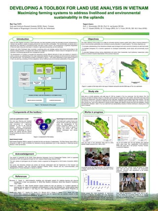
- 1. DEVELOPING A TOOLBOX FOR LAND USE ANALYSIS IN VIETNAM Maximizing farming systems to address livelihood and environmental sustainability in the uplands Bui Tan YEN Supervisors: Soils and Fertilizers Research Institute (SFRI), Hanoi, Vietnam Prof. L. Stroosnijder (WUR), Prof. H. van Keulen (WUR), PhD student of Wageningen University (WUR), the Netherlands Dr. C.T. Hoanh (IWMI), Dr. D. Orange (IRD), Dr. S. Visser (WUR), DR. B.H. Hien (SFRI) Introduction Objectives Same as other neighbor countries in South East Asia, the rapid population growth and favorable economic development in The major objective of the project is to create an innovative decision support system that is able to improve livelihood of Vietnam has resulted in rapidly increasing demand for food and other commodities. The transformation of sloping land to farmer, environmental sustainability and contribute to poverty alleviation in upland systems. The others objectives are: agricultural use, especially in mountainous areas, has been a major concern. The consequence is significant degradation - To increase understanding of the interactions between agro-ecological and socio-economic dynamics at catchment scale; of land and water resources that result in a decline in agricultural productivity and the livelihoods. - To facilitate emergence of a common agreement on ecological sustainability, social equity and economically sound Vietnam and other Southeast Asian countries is exploring policy and strategic options that involve communities in the solutions; decision making process. It is argued that cultures and indigenous knowledge of natural resource management are very important in developing appropriate land management policies. - To stimulate dialogues among various stakeholders and actors (farm households, local institutions, researchers, policy makers) to achieve a shared responsibility of the common resources. The development of a toolbox to simulate the interactions among different elements of land use systems is required in order to improve our understanding of the major relationship between the agro-ecological and socio-economic dynamics at the catchment level. The framework of project is illustrated in Figure 1. This project addresses to three aspects (Figure 3) of land use planning, consisting of farmer adaptation, farmer livelihood and environmental sustainability in the upland. (2) LAND USE OPTIMIZATION MODEL (LUPAS) (1) SOIL EROSION Que MODEL (PLER) Ray Problem MGLP and 940 m definitions Trade-off analysis Biophysical factors Con 500 m Optimal land use Socio-economic scenario condition Role Playing 140 m Policy Games Figure 2. Location of the study site in the map of Vietnam (red point) and the DEM map of Thu Cuc catchment (3) AGENT-BASED MODEL (ABM) Study site FEASIBLE OPTIMAL LAND-USE SCENARIOS AT CATCHMENT SCALE Study site is a small catchment, with total area of 1700 ha, located in Thu Cuc commune, Tan Son district, Phu Tho province, the North of Vietnam (Figure 2). Elevation of the catchment ranges from 140 to 940m. About 80% total area of the catchment is sloping land. Flat land occupies only 20% total area, consisting of small paddy fields along streams. The land Natural resource conservation Livelihood improvement use diversity of Thu Cuc catchment is reflected by the presence of different types of forest, fallow, tea, cassava, rice and other annual crop. Land of the catchment is owned by there villages with different cultures and land use strategies. Poverty and backward cultivation habit in Thu Cuc catchment are representative situation of farmer livelihood in sloping land in the Figure 1. The framework of the project north of Vietnam. Components of the toolbox Works in progress Farmer livelihood Land use optimization model Hydrological and erosion model y i lit ab The Land Use Planning and Analysis The Predict and Localize Erosion and n tai System (LUPAS) is a tool to explore the Runoff (PLER) model was developed us outer boundaries of agricultural under the Management of Soil ls nta potentials, as well as the trade-offs Erosion Consortium (MSEC). In this me between various socio-economic project, PLER model is applied to on Fa objectives and ecological sustainability. estimate soil erosion risk under rm v ir En er The LUPAS methodology is used to different landscapes and climate ’s ad identify the optimal land-use options conditions. ap through analyzing the share of common ta tio resources. n Figure 3. Components of the toolbox Agent-based model Agent-Based Modeling (ABM) is applied to simulate the land use decision of stakeholders. The Role Playing Game (RPG), a component of ABM, is used to facilitate the interactions among stakeholders and to help researcher in observing farmer’s Land use maps of the catchment were built by using The 24 soil profiles and 100 soil samples was collected behavior in land use decision. satellite images acquired from 1989 to 2007. within study area. Soil classification (FAO-UNRSCO- WRB) was done with 4 soil groups: Fluvisols, Acrisols, Luvisols and Regosols. Acknowledgement This project is supported by the Ginés- Mera Memorial Fellowship Fund for Postgraduate Studies, which is supported financially by IDRC and organized through the CIAT Cassava Biotechnology Network (CBN). The work relates to hydrological and soil erosion model is supported by Management of Soil Erosion Consortium (MSEC) project. Soil survey and laboratory analysis are carried out through collaboration with the Department of Soil Genesis and Classification Research, Soils and Fertilizers Research Institute (SFRI), Vietnam and the Community-based Land Management for Poverty Alleviation in Vietnam (CLMPAV). Household survey has been done with 100 households in Cassava and other annual crops are grown on steep 3 villages, approximately 25% of total households in whole slope with low input and without soil conservation catchment. measures. Therefore, land degradation is the evident problem in this area. 100 References 75 F re q u e n c y 50 Bousquet, F., Trebuil, G., 2004.Companion modelling and multi-agent systems for collective learning and resource management in Asian rice ecosystems. In: World Rice Research Conference. World Rice Research Conference, 25 Tokyo, Japan. 0 Hoanh, C.T., Roetter, R., 1998. Towards decision support systems for land use planning. In: A systems approach to analyzing land use options for sustainable rural development in South and Southeast Asia. SysNet special project st ea et ur al ds e n Pe u tio rk p it bo Ar ee niq Ma ga Ca La Br report, Roetter, R., Hoanh, C.T. and Teng, P.S. (Ed.), International Rice Research Institute, Manila, Philippines, pp. ch i Ir r Te 6-13. Dificulties Roetter, R.P., Hoanh, C.T., Laborte, A.G., Keulen, H.V., Ittersum, M.K.V., Dreiser, C., Diepen, C.A.V., Ridder, N.D., Laar, Survey shows the most constraints of agricultural Field visit of supervisors in 2007. From left to right: H.H.V., 2005. Integration of systems network (SysNet) tools for regional land use scenario analysis in Asia. production in Thu Cuc are capital, land area, technique B.T.Yen (SFRI), Dr. C.T.Hoanh (IWMI), Dr. D. Orange Environmental Modelling and Software 20, 291-307. and labor. These constraints are being used in the land (IRD), Dr. M.V.Trinh (SFRI), Prof. L.Stroosnijder (WUR) Vien, T.D., 2003. Culture, Environment, and Farming Systems in Vietnam’s Northern Mountain Region. Journal of Southeast use optimization model (LUPAS) and also Agent-Based and Prof. H. van Keulen (WUR). Asian Studies 41 (2), 180-205. Model (ABM) to explore feasible land use option for the catchment.