Recommandé

Recommandé
Contenu connexe
Plus de CTA
Plus de CTA (20)
Dernier
Dernier (15)
Identifying suitable areas for water harvesting in the upper Blue Nile basin, Ethiopia - Yihun Dile, Louise Karlberg , Johan Rockström, Stockholm Environment Institute, Ethiopia
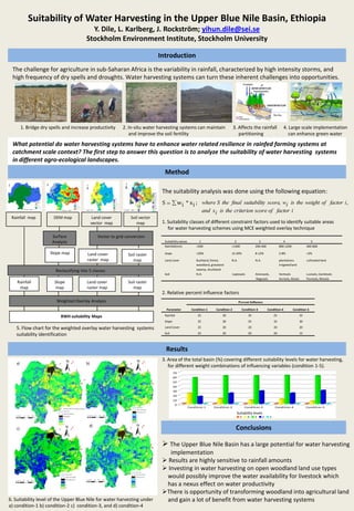
- 1. Suitability of Water Harvesting in the Upper Blue Nile Basin, Ethiopia Y. Dile, L. Karlberg, J. Rockström; yihun.dile@sei.se Stockholm Environment Institute, Stockholm University Introduction The challenge for agriculture in sub-Saharan Africa is the variability in rainfall, characterized by high intensity storms, and high frequency of dry spells and droughts. Water harvesting systems can turn these inherent challenges into opportunities. 1. Brídge dry spells and increase productivity 2. In-situ water harvesting systems can maintain 3. Affects the rainfall 4. Large scale implementation and improve the soil fertility partitioning can enhance green water What potential do water harvesting systems have to enhance water related resilience in rainfed farming systems at catchment scale context? The first step to answer this question is to analyze the suitability of water harvesting systems in different agro-ecological landscapes. Method The suitability analysis was done using the following equation: S w i * x i ; where S the final suitability score, wi is the weight of factor i , and xi is the criterion score of factor i Rainfall map DEM map Land cover Soil vector vector map map 1. Suitability classes of different constraint factors used to identify suitable areas for water harvesting schemes using MCE weighted overlay technique Surface Vector to grid conversion Analysis Suitability values 1 2 3 4 5 Rainfall(mm) <200 >1200 200-400 800-1200 400-800 Slope map Land cover Soil raster slope >20% 12-20% 8-12% 2-8% <2% raster map map Land cover Bushland, forest, N.A. N.A. plantations cultivated land woodland, grassland irrigated land Reclassifying into 5 classes swamp, shurbland Soil N.A. Leptosols Arenosols, Vertisols Luvisols, Cambisols Regosols Acrisols, Alisols Fluvisols, Nitisols Rainfall Slope Land cover Soil raster map map raster map map 2. Relative percent influence factors Weighted Overlay Analysis Percent Influence Parameter Condition-1 Condition-2 Condition-3 Condition-4 Condition-5 RWH suitability Maps Rainfall 25 30 35 25 35 Slope 25 30 25 35 30 5. Flow chart for the weighted overlay water harvesting systems Land Cover 25 20 20 20 20 Soil 25 20 20 20 15 suitability identification Results 3. Area of the total basin (%) covering different suitability levels for water harvesting, a) b) for different weight combinations of influencing variables (condition 1-5). 70 60 50 40 30 20 10 0 Condition 1 Condition-2 Condition-3 Condition-4 Condition-5 Suitability levels 5 4 3 2 1 d) c) Conclusions The Upper Blue Nile Basin has a large potential for water harvesting implementation Results are highly sensitive to rainfall amounts Investing in water harvesting on open woodland land use types would possibly improve the water availability for livestock which has a nexus effect on water productivity There is opportunity of transforming woodland into agricultural land 6. Suitability level of the Upper Blue Nile for water harvesting under and gain a lot of benefit from water harvesting systems a) condition-1 b) condition-2 c) condition-3, and d) condition-4