1. 1 | P a g e W h a t i s L . R . I . T . S y s t e m ?
For more details please visit: www.captyashpal.blogspot.com
LONG RANGE IDENTIFICATION
AND TRACKING SYSTEM
What is L.R.I.T.?
The acronym LRIT stands for Long Range Identification and
Tracking. It provides for identification and allows for tracking of
ships on global scale. It is a maritime security initiative that lets
2. 2 | P a g e W h a t i s L . R . I . T . S y s t e m ?
For more details please visit: www.captyashpal.blogspot.com
SOLAS Contracting Governments to request and receive position
reports from:
Vessels operating under their flag.
Vessels indicating their intentions to enter a port under their
jurisdiction.
Vessels operating within 1000 nautical miles of their coast.
The regulations also allow LRIT for use in search and rescue
missions, in addition to addressing the maritime security.
In this context, contracting governments and SAR services are
collectively termed as LRIT data users.
Mandatory Carriage:
3. 3 | P a g e W h a t i s L . R . I . T . S y s t e m ?
For more details please visit: www.captyashpal.blogspot.com
The new regulation mandating the carriage of LRIT equipment on
ships is included in Chapter V entitled “Safety of Navigation”, of
SOLAS. Following ships on international voyages are required to
be fitted with LRIT equipment:
Passenger ships, including high-speed craft;
Cargo ships, including high-speed craft, of 300 gross tonnage
and upwards;
And mobile offshore drilling units.
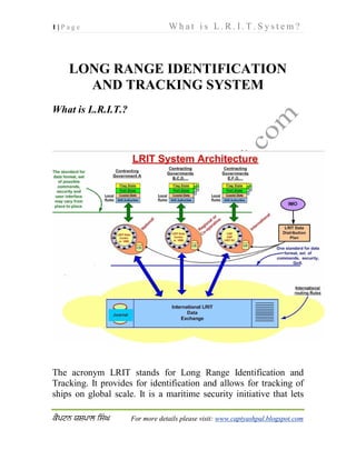
Inmarsat
Satellite
Simplified LRIT Diagram (Captain Yashpal Singh)
International
Data Exchange
Other Data
Centers
D.D.P.
A.S.P. /
Data
Centre
C.S.P.
Flag State Port StatesS.A.R.s
Ship transmitting
LRIT Information
4. 4 | P a g e W h a t i s L . R . I . T . S y s t e m ?
For more details please visit: www.captyashpal.blogspot.com
LRIT System:
The LRIT system consists of:
i. The ship-borne LRIT information transmitting equipment.
ii. The Communication Service Provider(s).
iii. The Application Service Provider(s).
iv. The LRIT Data Centre(s), including any related Vessel
Monitoring System(s).
v. The LRIT Data Distribution Plan.
vi. And the International LRIT Data Exchange.
Certain aspects of the performance of the LRIT system are subject
to review or audit by an LRIT Co-coordinator acting on behalf of
all Contracting Governments.
LRIT information:
LRIT information comprises:
The identity of the ship.
The position of the ship.
The date and time of the position.
Dissemination of LRIT information:
LRIT information is provided to:
Contracting Governments;
And SAR (search and rescue) services entitled to receive the
information, upon request.
5. 5 | P a g e W h a t i s L . R . I . T . S y s t e m ?
For more details please visit: www.captyashpal.blogspot.com
The LRIT information is received through a system of National,
Regional, Cooperative and International LRIT Data Centers, using
where necessary, the International LRIT Data Exchange.
Administration’s task:
Each Administration (contracting government) should select a
LRIT Data Centre, and ensure following:
A list of the ships entitled to fly its flag, which are required to
transmit LRIT information, together with other salient details
should be provided to the selected LRIT Data centre.
Such lists should be updated, without undue delay, as and
when changes occur (for example, ships getting out of
service, new ships flying the flag or existing ships choosing
to register with other flag).
Ships should only transmit the LRIT information to the LRIT Data
Centre selected by their Administration.
Operation of LRIT equipment:
Ship-borne LRIT equipment should be capable of
transmitting the ship’s LRIT information at 15 minutes to 6-
hour intervals to an LRIT Data Centre, automatically and
without human intervention.
It should be possible to vary transmission intervals of the
LRIT information by configuring the equipment remotely to
the desired interval. This is usually achieved by using
Inmarsat technology. This type of remote control is already
being done with Inmarsat C, mini-C and D+.
6. 6 | P a g e W h a t i s L . R . I . T . S y s t e m ?
For more details please visit: www.captyashpal.blogspot.com
It should be capable of transmitting LRIT information in
response to the requests received i.e. following receipt of
polling commands.
The ship borne equipment should be set to automatically
transmit the ship’s LRIT information at 6-hour intervals to
the LRIT Data Centre identified by the Administration,
unless the LRIT Data User requesting the provision of LRIT
information specifies a more frequent transmission interval.
Coverage and Exemption:
The ship-borne LRIT equipment should transmit the LRIT
information using a communication system which provides
coverage in all areas where the ship operates.
Ships operating exclusively in sea area A1 are exempted
from the requirement to transmit LRIT information, since
such ships are already fitted with AIS, which provides for
identification and tracking within the VHF range requirement
of sea area A1.
Can LRIT information transmission be stopped or the
rate slowed?
Yes, when a ship is undergoing repairs, modifications or
conversions in dry-dock or in port or is laid up for a long period,
the master or the Administration may reduce the frequency of the
transmission of LRIT information to one transmission every 24-
hour period, or may temporarily stop the transmission of such
information.
Power supply and Interfacing:
7. 7 | P a g e W h a t i s L . R . I . T . S y s t e m ?
For more details please visit: www.captyashpal.blogspot.com
LRIT equipment will be supplied with energy from the main
and emergency source of electrical power.
LRIT equipment will be interfaced directly to the ship borne
global navigation satellite system equipment (GPS, for
example), or have internal positioning capability.
LRIT information and SAR:
The LRIT information should be provided irrespective of the
location of the geographical area and should be provided even if
the geographical area is outside the search and rescue region
associated with the SAR service requesting the information.
However, Search and Rescue service should request the
LRIT information only via the LRIT Data Centre serving the
Contracting Government in whose territory the service is located.
All LRIT Data Centers should provide to SAR services,
LRIT information transmitted by all ships located within the
geographical area specified by the SAR service requesting the
information so as to permit the rapid identification of ships which
may be called upon to provide assistance in relation to the search
and rescue of persons in distress at sea.
On the other hand, Search and Rescue (SAR) services
should provide information, subject to the provisions of the
national legislation of the Contracting Government concerned,
when requested by the LRIT Coordinator to enable the holistic
review of the performance of the LRIT system and for the
investigation of any disputes.
LRIT and AIS:
Following salient features mark the distinction between LRIT ship-
borne equipment and AIS:
8. 8 | P a g e W h a t i s L . R . I . T . S y s t e m ?
For more details please visit: www.captyashpal.blogspot.com
1. The LRIT information transmitted by ships consists of just
the ship's identity, location and date and time of the position.
While AIS provides a considerable amount of information
about a ship in the categories of static, dynamic and voyage-
related information packets.
2. While LRIT system is long-range and provides global
coverage, the reach of AIS is same as VHF range, which,
under normal circumstances, is about 40 to 50 nautical miles.
3. AIS is a broadcast system. This means that any station
equipped with an AIS and within VHF range, can have
access to the information transmitted. LRIT information,
however, will be available only to the LRIT data users
(recipients who are entitled to receive such information).
In the light of the above, it is important to note that there should be
no interface between the AIS and the ship-borne LRIT equipment.
LRIT Certificate:
LRIT certificate is a document issued by the flag state. It testifies
that the ship-borne LRIT equipment is of a type approved by the
Administration and has passed a Conformance Test conducted by
an authorized testing Application Service Provider (ASP).
On satisfactory completion of a conformance test, the Authorized
Testing ASP conducting the test issues a report to the
Administration to support and serve as the basis for the Certificate
that is issued by the Administration to the ship owner for placing
on board their vessel.
No additional action is required on part of the ship owner once the
test has been successfully completed and passed, since the test
report data is automatically forwarded to the Administration by the
authorized testing ASP.
9. 9 | P a g e W h a t i s L . R . I . T . S y s t e m ?
For more details please visit: www.captyashpal.blogspot.com
Legal aspects:
The SOLAS regulation on LRIT establishes a multilateral
agreement for sharing LRIT information for security and search
and rescue purposes, amongst SOLAS Contracting Governments,
in order to meet the maritime security needs and other concerns of
such Governments.
The SOLAS regulation on LRIT, however, does not create or
affirm any new rights of States over ships.
It is, therefore, important to keep in mind that nothing in the
regulation or the provisions of performance standards and
functional requirements adopted by the IMO in relation to the
long-range identification and tracking of ships, shall prejudice the
rights, jurisdiction or obligations of States under international law,
in particular, the legal regimes of the high seas, {the United
Nations Convention on the Law of the Sea (UNCLOS)}, the
exclusive economic zone, the contiguous zone, the territorial seas
or the straits used for international navigation and archipelagic sea
lanes.
In operating the LRIT system, recognition should be given to
international conventions, agreements, rules or standards that
provide for the protection of navigational information.
The right of flag States to protect information about the ships
entitled to fly their flag is also maintained, where appropriate,
while allowing coastal States the access to information about ships
navigating off their coasts.
Data security:
Data (LRIT information) security is achieved by following four
methods:
Authorization:
10. 10 | P a g e W h a t i s
L . R . I . T . S y s t e m ?
For more details please visit: www.captyashpal.blogspot.com
Access is granted only to those who are authorized to see the
specific LRIT information.
Authentication:
Any party exchanging information within the LRIT system is
required to provide authentication before exchanging information.
Confidentiality:
The confidentiality of the LRIT information is protected by
ensuring that it is not disclosed to unauthorized recipients when it
travels across the LRIT system.
Integrity:
The integrity of the LRIT information is maintained during its
travel through the system by ensuring that no data is altered.
Relevant definitions:
LRIT Data User:
It means a Contracting Government or a Search and Rescue (SAR)
service which opts to receive the LRIT information it is entitled to.
Vessel Monitoring System:
It means a system established by a Contracting Government or a
group of Contracting Governments to monitor the movements of
the ships entitled to fly its or their flag. A Vessel Monitoring
System may also collect from the ships information specified by
the Contracting Government(s) which has established it.