SlideShare une entreprise Scribd logo
1  sur  4
Télécharger pour lire hors ligne
A Common Platform:
Rapidly Responding to and
Recovering from Colorado's
Historic Floods
Contact Information
Tabatha Waldron
GeospatialAnalyst
Colorado Department of
Public Safety
Division of Homeland Security
Emergency Management
(DHSEM)
E-mail:
tabatha.waldron@state.co.us
Patrick Good
ElectricalEngineer
Longmont Power &
Communications
E-mail:
Patrick.Good@ci.longmont.co.us
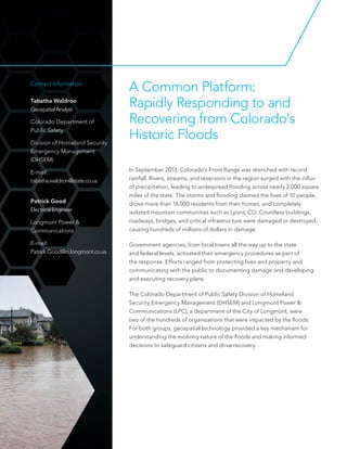
In September 2013, Colorado's Front Range was drenched with record
rainfall. Rivers, streams, and reservoirs in the region surged with the influx
of precipitation, leading to widespread flooding across nearly 2,000 square
miles of the state. The storms and flooding claimed the lives of 10 people,
drove more than 18,000 residents from their homes, and completely
isolated mountain communities such as Lyons, CO. Countless buildings,
roadways, bridges, and critical infrastructure were damaged or destroyed,
causing hundreds of millions of dollars in damage.
Government agencies, from local towns all the way up to the state
and federal levels, activated their emergency procedures as part of
the response. Efforts ranged from protecting lives and property and
communicating with the public to documenting damage and developing
and executing recovery plans.
The Colorado Department of Public Safety Division of Homeland
Security Emergency Management (DHSEM) and Longmont Power &
Communications (LPC), a department of the City of Longmont, were
two of the hundreds of organizations that were impacted by the floods.
For both groups, geospatial technology provided a key mechanism for
understanding the evolving nature of the floods and making informed
decisions to safeguard citizens and drive recovery.
The Challenge
As the primary state response agency, Colorado
DHSEM was tasked with understanding where
flooding occurred and determining where to
deploy response assets. The department needed
a platform to share information and perform
analysis in real time to coordinate activities across
multiple agencies.
With a service territory of 49 square miles
covering the towns of Longmont and Hygiene and
parts of Lyons, LPC was hit particularly hard by
the storm. Significant portions of its infrastructure
were damaged, and approximately 1,300
customers were without power for several days.
LPC staff needed a way to efficiently manage
inspections and repair infrastructure.
The Solution
Both Colorado DHSEM and LPC used ArcGIS
SM
Online to visualize information related to the
floods and impacted areas. ArcGIS Online enabled
Colorado DHSEM and LPC to share continuously
updated live maps with staff located in the field and
in offices throughout the state.
Coloardo DHSEM worked with local, state, federal,
and private partners to collect imagery and
geospatial information to create maps related
to everything from road closures and traffic
control points to evacuation areas and damaged
facilities. The myriad maps and data created a
common operating platform that decision makers
were able to access in support of response and
recovery efforts. Regional field managers and other
Streams and rivers surged, overrunning banks and
affecting bridges and pathways.
Widespread flooding left
residential communities and
commercial properties completely
inaccessible.
personnel used the maps to maintain situational
awareness and make informed decisions that
supported their local counterparts.
In addition to ArcGIS Online, LPC also used
Collector for ArcGIS, a configurable app for
smartphones and tablets that enables field data
collection and syncs with online maps. Field crews
used Collector for ArcGIS to inspect high-voltage
equipment in the field. Their reports were fed into
an online map that was instantly updated on all the
crews' devices. This let field personnel see what
had already been inspected and allowed them to
perform their work in smaller groups.
Flood waters caused severe damage to roadways
and other infrastructure throughout the state.
Copyright © 2014 Esri. All rights reserved. Esri, the Esri globe logo, ArcGIS, @esri.com, and esri.com are trademarks, service marks, or
registered marks of Esri in the United States, the European Community, or certain other jurisdictions. Other companies and products
or services mentioned herein may be trademarks, service marks, or registered marks of their respective mark owners.
G64229
ESRI6/14ek
The Results
The online maps created by Colorado DHSEM
were accessed by hundreds of users to visualize
impacted areas and orchestrate response efforts.
Other online maps, such as those identifying disaster
recovery centers, were also shared with the public.
The common operating platform offered by ArcGIS
helped leaders understand the size, scope, and
proximity of the crisis.
Collector for ArcGIS empowered LPC to complete
inspections of all damaged assets in just three days.
By replacing paper maps and dispatch lists, LPC was
able to operate more efficiently and quickly perform
critical tasks. In all, the ArcGIS platform helped LPC
gain a better understanding of the impact of the
floods and lowered costs by optimizing the efforts of
its field crews.
As inspections were completed in the field, they were
immediately recorded on an ArcGIS Online map that field
workers and office staff monitored.
Collector for ArcGIS helped field crews
stay updated about where inspections had
occurred and where to focus repair efforts.

Contenu connexe

Similaire à A Common Platform: Flood Response

Esri News for State and Local Government Spring 2013 issue
Esri News for State and Local Government Spring 2013 issueEsri News for State and Local Government Spring 2013 issue
Esri News for State and Local Government Spring 2013 issueEsri
 
Richland_County_JMG_Award_Application_2016
Richland_County_JMG_Award_Application_2016Richland_County_JMG_Award_Application_2016
Richland_County_JMG_Award_Application_2016Patrick Bresnahan
 
Spring 2013
Spring 2013Spring 2013
Spring 2013Esri
 
Esri News for State & Local Government newsletter
Esri News for State & Local Government newsletterEsri News for State & Local Government newsletter
Esri News for State & Local Government newsletterEsri
 
Esri News for Water Resources Winter 2012/2013 newsletter
Esri News for Water Resources Winter 2012/2013 newsletterEsri News for Water Resources Winter 2012/2013 newsletter
Esri News for Water Resources Winter 2012/2013 newsletterEsri
 
ResponsetoPlannningCommission_DSAP_DEIR
ResponsetoPlannningCommission_DSAP_DEIRResponsetoPlannningCommission_DSAP_DEIR
ResponsetoPlannningCommission_DSAP_DEIRKenneth Rosales
 
Summer 2013
Summer 2013Summer 2013
Summer 2013Esri
 
Hurricane conference 2010
Hurricane conference 2010Hurricane conference 2010
Hurricane conference 2010Chatham EMA
 
Jim Proce 2017 APWA Project of the Year Application - EF4 Tornado
Jim Proce   2017 APWA Project of the Year Application - EF4 TornadoJim Proce   2017 APWA Project of the Year Application - EF4 Tornado
Jim Proce 2017 APWA Project of the Year Application - EF4 TornadoJim Proce
 
Jim Proce - Rowlett Public Works 2017 APWA Project of the Year Application - ...
Jim Proce - Rowlett Public Works 2017 APWA Project of the Year Application - ...Jim Proce - Rowlett Public Works 2017 APWA Project of the Year Application - ...
Jim Proce - Rowlett Public Works 2017 APWA Project of the Year Application - ...Jim Proce
 
Sea Level Rise & the Conservation of Wetlands: Issues and Opportunities for C...
Sea Level Rise & the Conservation of Wetlands: Issues and Opportunities for C...Sea Level Rise & the Conservation of Wetlands: Issues and Opportunities for C...
Sea Level Rise & the Conservation of Wetlands: Issues and Opportunities for C...riseagrant
 
'Beds in Sheds'/Rogue Landlords Case Study at Slough with PBS MapInfo
'Beds in Sheds'/Rogue Landlords Case Study at Slough with PBS MapInfo'Beds in Sheds'/Rogue Landlords Case Study at Slough with PBS MapInfo
'Beds in Sheds'/Rogue Landlords Case Study at Slough with PBS MapInfoRichard Rollins
 
Coastal Urban DEM project - Mapping the vulnerability of Australia's Coast
Coastal Urban DEM project - Mapping the vulnerability of Australia's CoastCoastal Urban DEM project - Mapping the vulnerability of Australia's Coast
Coastal Urban DEM project - Mapping the vulnerability of Australia's CoastFungis Queensland
 
An Effective Tool for Drinking Water Protection
An Effective Tool for Drinking Water ProtectionAn Effective Tool for Drinking Water Protection
An Effective Tool for Drinking Water ProtectionEsri
 
Allinsite warankqa 1 ¨demo¨ (1)
Allinsite   warankqa 1 ¨demo¨ (1)Allinsite   warankqa 1 ¨demo¨ (1)
Allinsite warankqa 1 ¨demo¨ (1)MarcelineHR
 
ICLR Friday Forum: Edmonton's approach to stormwater flood mgmt (July 16, 2021)
ICLR Friday Forum: Edmonton's approach to stormwater flood mgmt (July 16, 2021)ICLR Friday Forum: Edmonton's approach to stormwater flood mgmt (July 16, 2021)
ICLR Friday Forum: Edmonton's approach to stormwater flood mgmt (July 16, 2021)glennmcgillivray
 
Sunu (1) kopyası kopyası (1)
Sunu (1) kopyası kopyası (1)Sunu (1) kopyası kopyası (1)
Sunu (1) kopyası kopyası (1)demirdemirel
 
Charlotte UAV : An Ideal Partner for Mecklenburg County
Charlotte UAV : An Ideal Partner for Mecklenburg CountyCharlotte UAV : An Ideal Partner for Mecklenburg County
Charlotte UAV : An Ideal Partner for Mecklenburg CountyBretten Smith
 

Similaire à A Common Platform: Flood Response (20)

Esri News for State and Local Government Spring 2013 issue
Esri News for State and Local Government Spring 2013 issueEsri News for State and Local Government Spring 2013 issue
Esri News for State and Local Government Spring 2013 issue
 
Richland_County_JMG_Award_Application_2016
Richland_County_JMG_Award_Application_2016Richland_County_JMG_Award_Application_2016
Richland_County_JMG_Award_Application_2016
 
Spring 2013
Spring 2013Spring 2013
Spring 2013
 
Esri News for State & Local Government newsletter
Esri News for State & Local Government newsletterEsri News for State & Local Government newsletter
Esri News for State & Local Government newsletter
 
Esri News for Water Resources Winter 2012/2013 newsletter
Esri News for Water Resources Winter 2012/2013 newsletterEsri News for Water Resources Winter 2012/2013 newsletter
Esri News for Water Resources Winter 2012/2013 newsletter
 
ResponsetoPlannningCommission_DSAP_DEIR
ResponsetoPlannningCommission_DSAP_DEIRResponsetoPlannningCommission_DSAP_DEIR
ResponsetoPlannningCommission_DSAP_DEIR
 
Summer 2013
Summer 2013Summer 2013
Summer 2013
 
Hurricane conference 2010
Hurricane conference 2010Hurricane conference 2010
Hurricane conference 2010
 
Jim Proce 2017 APWA Project of the Year Application - EF4 Tornado
Jim Proce   2017 APWA Project of the Year Application - EF4 TornadoJim Proce   2017 APWA Project of the Year Application - EF4 Tornado
Jim Proce 2017 APWA Project of the Year Application - EF4 Tornado
 
Jim Proce - Rowlett Public Works 2017 APWA Project of the Year Application - ...
Jim Proce - Rowlett Public Works 2017 APWA Project of the Year Application - ...Jim Proce - Rowlett Public Works 2017 APWA Project of the Year Application - ...
Jim Proce - Rowlett Public Works 2017 APWA Project of the Year Application - ...
 
Sea Level Rise & the Conservation of Wetlands: Issues and Opportunities for C...
Sea Level Rise & the Conservation of Wetlands: Issues and Opportunities for C...Sea Level Rise & the Conservation of Wetlands: Issues and Opportunities for C...
Sea Level Rise & the Conservation of Wetlands: Issues and Opportunities for C...
 
'Beds in Sheds'/Rogue Landlords Case Study at Slough with PBS MapInfo
'Beds in Sheds'/Rogue Landlords Case Study at Slough with PBS MapInfo'Beds in Sheds'/Rogue Landlords Case Study at Slough with PBS MapInfo
'Beds in Sheds'/Rogue Landlords Case Study at Slough with PBS MapInfo
 
Thesis
ThesisThesis
Thesis
 
Superfund sites
Superfund sitesSuperfund sites
Superfund sites
 
Coastal Urban DEM project - Mapping the vulnerability of Australia's Coast
Coastal Urban DEM project - Mapping the vulnerability of Australia's CoastCoastal Urban DEM project - Mapping the vulnerability of Australia's Coast
Coastal Urban DEM project - Mapping the vulnerability of Australia's Coast
 
An Effective Tool for Drinking Water Protection
An Effective Tool for Drinking Water ProtectionAn Effective Tool for Drinking Water Protection
An Effective Tool for Drinking Water Protection
 
Allinsite warankqa 1 ¨demo¨ (1)
Allinsite   warankqa 1 ¨demo¨ (1)Allinsite   warankqa 1 ¨demo¨ (1)
Allinsite warankqa 1 ¨demo¨ (1)
 
ICLR Friday Forum: Edmonton's approach to stormwater flood mgmt (July 16, 2021)
ICLR Friday Forum: Edmonton's approach to stormwater flood mgmt (July 16, 2021)ICLR Friday Forum: Edmonton's approach to stormwater flood mgmt (July 16, 2021)
ICLR Friday Forum: Edmonton's approach to stormwater flood mgmt (July 16, 2021)
 
Sunu (1) kopyası kopyası (1)
Sunu (1) kopyası kopyası (1)Sunu (1) kopyası kopyası (1)
Sunu (1) kopyası kopyası (1)
 
Charlotte UAV : An Ideal Partner for Mecklenburg County
Charlotte UAV : An Ideal Partner for Mecklenburg CountyCharlotte UAV : An Ideal Partner for Mecklenburg County
Charlotte UAV : An Ideal Partner for Mecklenburg County
 

Plus de Esri

INIA- CISA: Análisis de las amenazas en la fauna silvestre
INIA- CISA: Análisis de las amenazas en la fauna silvestreINIA- CISA: Análisis de las amenazas en la fauna silvestre
INIA- CISA: Análisis de las amenazas en la fauna silvestreEsri
 
Aena Aeropuerto Adolfo Suárez-Barajas crea potentes aplicaciones para sus cli...
Aena Aeropuerto Adolfo Suárez-Barajas crea potentes aplicaciones para sus cli...Aena Aeropuerto Adolfo Suárez-Barajas crea potentes aplicaciones para sus cli...
Aena Aeropuerto Adolfo Suárez-Barajas crea potentes aplicaciones para sus cli...Esri
 
Plataforma Smart City de Móstoles
Plataforma Smart City de MóstolesPlataforma Smart City de Móstoles
Plataforma Smart City de MóstolesEsri
 
ArcGIS Online para Organizaciones
ArcGIS Online para OrganizacionesArcGIS Online para Organizaciones
ArcGIS Online para OrganizacionesEsri
 
Molina de Segura se convierte en una smart city
Molina de Segura se convierte en una smart cityMolina de Segura se convierte en una smart city
Molina de Segura se convierte en una smart cityEsri
 
Portal for ArcGIS
Portal for ArcGISPortal for ArcGIS
Portal for ArcGISEsri
 
GIS-Based Web Services Provide Rapid Analysis and Dissemination of Maritime Data
GIS-Based Web Services Provide Rapid Analysis and Dissemination of Maritime DataGIS-Based Web Services Provide Rapid Analysis and Dissemination of Maritime Data
GIS-Based Web Services Provide Rapid Analysis and Dissemination of Maritime DataEsri
 
GeoCollector for ArcPad
GeoCollector for ArcPadGeoCollector for ArcPad
GeoCollector for ArcPadEsri
 
GeoCollector for ArcGIS for Windows Mobile
GeoCollector for ArcGIS for Windows MobileGeoCollector for ArcGIS for Windows Mobile
GeoCollector for ArcGIS for Windows MobileEsri
 
Esri and BlackBridge
Esri and BlackBridgeEsri and BlackBridge
Esri and BlackBridgeEsri
 
GeoPlanner for ArcGIS
GeoPlanner for ArcGISGeoPlanner for ArcGIS
GeoPlanner for ArcGISEsri
 
Esri and AccuWeather
Esri and AccuWeatherEsri and AccuWeather
Esri and AccuWeatherEsri
 
Esri and Airbus Defense & Space
Esri and Airbus Defense & SpaceEsri and Airbus Defense & Space
Esri and Airbus Defense & SpaceEsri
 
Esri US Data Fact Sheet
Esri US Data Fact SheetEsri US Data Fact Sheet
Esri US Data Fact SheetEsri
 
ArcGIS for Server on Microsoft Azure Jumpstart
ArcGIS for Server on Microsoft Azure JumpstartArcGIS for Server on Microsoft Azure Jumpstart
ArcGIS for Server on Microsoft Azure JumpstartEsri
 
ArcGIS for the Military--Maritime Operations
ArcGIS for the Military--Maritime OperationsArcGIS for the Military--Maritime Operations
ArcGIS for the Military--Maritime OperationsEsri
 
Esri Geoportal Server
Esri Geoportal ServerEsri Geoportal Server
Esri Geoportal ServerEsri
 
ArcGIS GeoEvent Extension for Server
ArcGIS GeoEvent Extension for ServerArcGIS GeoEvent Extension for Server
ArcGIS GeoEvent Extension for ServerEsri
 
ArcGIS for Desktop Tips and Shortcuts
ArcGIS for Desktop Tips and ShortcutsArcGIS for Desktop Tips and Shortcuts
ArcGIS for Desktop Tips and ShortcutsEsri
 
ArcGIS Online
ArcGIS OnlineArcGIS Online
ArcGIS OnlineEsri
 

Plus de Esri (20)

INIA- CISA: Análisis de las amenazas en la fauna silvestre
INIA- CISA: Análisis de las amenazas en la fauna silvestreINIA- CISA: Análisis de las amenazas en la fauna silvestre
INIA- CISA: Análisis de las amenazas en la fauna silvestre
 
Aena Aeropuerto Adolfo Suárez-Barajas crea potentes aplicaciones para sus cli...
Aena Aeropuerto Adolfo Suárez-Barajas crea potentes aplicaciones para sus cli...Aena Aeropuerto Adolfo Suárez-Barajas crea potentes aplicaciones para sus cli...
Aena Aeropuerto Adolfo Suárez-Barajas crea potentes aplicaciones para sus cli...
 
Plataforma Smart City de Móstoles
Plataforma Smart City de MóstolesPlataforma Smart City de Móstoles
Plataforma Smart City de Móstoles
 
ArcGIS Online para Organizaciones
ArcGIS Online para OrganizacionesArcGIS Online para Organizaciones
ArcGIS Online para Organizaciones
 
Molina de Segura se convierte en una smart city
Molina de Segura se convierte en una smart cityMolina de Segura se convierte en una smart city
Molina de Segura se convierte en una smart city
 
Portal for ArcGIS
Portal for ArcGISPortal for ArcGIS
Portal for ArcGIS
 
GIS-Based Web Services Provide Rapid Analysis and Dissemination of Maritime Data
GIS-Based Web Services Provide Rapid Analysis and Dissemination of Maritime DataGIS-Based Web Services Provide Rapid Analysis and Dissemination of Maritime Data
GIS-Based Web Services Provide Rapid Analysis and Dissemination of Maritime Data
 
GeoCollector for ArcPad
GeoCollector for ArcPadGeoCollector for ArcPad
GeoCollector for ArcPad
 
GeoCollector for ArcGIS for Windows Mobile
GeoCollector for ArcGIS for Windows MobileGeoCollector for ArcGIS for Windows Mobile
GeoCollector for ArcGIS for Windows Mobile
 
Esri and BlackBridge
Esri and BlackBridgeEsri and BlackBridge
Esri and BlackBridge
 
GeoPlanner for ArcGIS
GeoPlanner for ArcGISGeoPlanner for ArcGIS
GeoPlanner for ArcGIS
 
Esri and AccuWeather
Esri and AccuWeatherEsri and AccuWeather
Esri and AccuWeather
 
Esri and Airbus Defense & Space
Esri and Airbus Defense & SpaceEsri and Airbus Defense & Space
Esri and Airbus Defense & Space
 
Esri US Data Fact Sheet
Esri US Data Fact SheetEsri US Data Fact Sheet
Esri US Data Fact Sheet
 
ArcGIS for Server on Microsoft Azure Jumpstart
ArcGIS for Server on Microsoft Azure JumpstartArcGIS for Server on Microsoft Azure Jumpstart
ArcGIS for Server on Microsoft Azure Jumpstart
 
ArcGIS for the Military--Maritime Operations
ArcGIS for the Military--Maritime OperationsArcGIS for the Military--Maritime Operations
ArcGIS for the Military--Maritime Operations
 
Esri Geoportal Server
Esri Geoportal ServerEsri Geoportal Server
Esri Geoportal Server
 
ArcGIS GeoEvent Extension for Server
ArcGIS GeoEvent Extension for ServerArcGIS GeoEvent Extension for Server
ArcGIS GeoEvent Extension for Server
 
ArcGIS for Desktop Tips and Shortcuts
ArcGIS for Desktop Tips and ShortcutsArcGIS for Desktop Tips and Shortcuts
ArcGIS for Desktop Tips and Shortcuts
 
ArcGIS Online
ArcGIS OnlineArcGIS Online
ArcGIS Online
 

Dernier

DevEX - reference for building teams, processes, and platforms
DevEX - reference for building teams, processes, and platformsDevEX - reference for building teams, processes, and platforms
DevEX - reference for building teams, processes, and platformsSergiu Bodiu
 
Ensuring Technical Readiness For Copilot in Microsoft 365
Ensuring Technical Readiness For Copilot in Microsoft 365Ensuring Technical Readiness For Copilot in Microsoft 365
Ensuring Technical Readiness For Copilot in Microsoft 3652toLead Limited
 
Take control of your SAP testing with UiPath Test Suite
Take control of your SAP testing with UiPath Test SuiteTake control of your SAP testing with UiPath Test Suite
Take control of your SAP testing with UiPath Test SuiteDianaGray10
 
Tampa BSides - Chef's Tour of Microsoft Security Adoption Framework (SAF)
Tampa BSides - Chef's Tour of Microsoft Security Adoption Framework (SAF)Tampa BSides - Chef's Tour of Microsoft Security Adoption Framework (SAF)
Tampa BSides - Chef's Tour of Microsoft Security Adoption Framework (SAF)Mark Simos
 
DSPy a system for AI to Write Prompts and Do Fine Tuning
DSPy a system for AI to Write Prompts and Do Fine TuningDSPy a system for AI to Write Prompts and Do Fine Tuning
DSPy a system for AI to Write Prompts and Do Fine TuningLars Bell
 
"Subclassing and Composition – A Pythonic Tour of Trade-Offs", Hynek Schlawack
"Subclassing and Composition – A Pythonic Tour of Trade-Offs", Hynek Schlawack"Subclassing and Composition – A Pythonic Tour of Trade-Offs", Hynek Schlawack
"Subclassing and Composition – A Pythonic Tour of Trade-Offs", Hynek SchlawackFwdays
 
Nell’iperspazio con Rocket: il Framework Web di Rust!
Nell’iperspazio con Rocket: il Framework Web di Rust!Nell’iperspazio con Rocket: il Framework Web di Rust!
Nell’iperspazio con Rocket: il Framework Web di Rust!Commit University
 
Unraveling Multimodality with Large Language Models.pdf
Unraveling Multimodality with Large Language Models.pdfUnraveling Multimodality with Large Language Models.pdf
Unraveling Multimodality with Large Language Models.pdfAlex Barbosa Coqueiro
 
What's New in Teams Calling, Meetings and Devices March 2024
What's New in Teams Calling, Meetings and Devices March 2024What's New in Teams Calling, Meetings and Devices March 2024
What's New in Teams Calling, Meetings and Devices March 2024Stephanie Beckett
 
Passkey Providers and Enabling Portability: FIDO Paris Seminar.pptx
Passkey Providers and Enabling Portability: FIDO Paris Seminar.pptxPasskey Providers and Enabling Portability: FIDO Paris Seminar.pptx
Passkey Providers and Enabling Portability: FIDO Paris Seminar.pptxLoriGlavin3
 
Transcript: New from BookNet Canada for 2024: Loan Stars - Tech Forum 2024
Transcript: New from BookNet Canada for 2024: Loan Stars - Tech Forum 2024Transcript: New from BookNet Canada for 2024: Loan Stars - Tech Forum 2024
Transcript: New from BookNet Canada for 2024: Loan Stars - Tech Forum 2024BookNet Canada
 
From Family Reminiscence to Scholarly Archive .
From Family Reminiscence to Scholarly Archive .From Family Reminiscence to Scholarly Archive .
From Family Reminiscence to Scholarly Archive .Alan Dix
 
What is Artificial Intelligence?????????
What is Artificial Intelligence?????????What is Artificial Intelligence?????????
What is Artificial Intelligence?????????blackmambaettijean
 
The Ultimate Guide to Choosing WordPress Pros and Cons
The Ultimate Guide to Choosing WordPress Pros and ConsThe Ultimate Guide to Choosing WordPress Pros and Cons
The Ultimate Guide to Choosing WordPress Pros and ConsPixlogix Infotech
 
TeamStation AI System Report LATAM IT Salaries 2024
TeamStation AI System Report LATAM IT Salaries 2024TeamStation AI System Report LATAM IT Salaries 2024
TeamStation AI System Report LATAM IT Salaries 2024Lonnie McRorey
 
WordPress Websites for Engineers: Elevate Your Brand
WordPress Websites for Engineers: Elevate Your BrandWordPress Websites for Engineers: Elevate Your Brand
WordPress Websites for Engineers: Elevate Your Brandgvaughan
 
Digital Identity is Under Attack: FIDO Paris Seminar.pptx
Digital Identity is Under Attack: FIDO Paris Seminar.pptxDigital Identity is Under Attack: FIDO Paris Seminar.pptx
Digital Identity is Under Attack: FIDO Paris Seminar.pptxLoriGlavin3
 
Artificial intelligence in cctv survelliance.pptx
Artificial intelligence in cctv survelliance.pptxArtificial intelligence in cctv survelliance.pptx
Artificial intelligence in cctv survelliance.pptxhariprasad279825
 
SALESFORCE EDUCATION CLOUD | FEXLE SERVICES
SALESFORCE EDUCATION CLOUD | FEXLE SERVICESSALESFORCE EDUCATION CLOUD | FEXLE SERVICES
SALESFORCE EDUCATION CLOUD | FEXLE SERVICESmohitsingh558521
 
New from BookNet Canada for 2024: Loan Stars - Tech Forum 2024
New from BookNet Canada for 2024: Loan Stars - Tech Forum 2024New from BookNet Canada for 2024: Loan Stars - Tech Forum 2024
New from BookNet Canada for 2024: Loan Stars - Tech Forum 2024BookNet Canada
 

Dernier (20)

DevEX - reference for building teams, processes, and platforms
DevEX - reference for building teams, processes, and platformsDevEX - reference for building teams, processes, and platforms
DevEX - reference for building teams, processes, and platforms
 
Ensuring Technical Readiness For Copilot in Microsoft 365
Ensuring Technical Readiness For Copilot in Microsoft 365Ensuring Technical Readiness For Copilot in Microsoft 365
Ensuring Technical Readiness For Copilot in Microsoft 365
 
Take control of your SAP testing with UiPath Test Suite
Take control of your SAP testing with UiPath Test SuiteTake control of your SAP testing with UiPath Test Suite
Take control of your SAP testing with UiPath Test Suite
 
Tampa BSides - Chef's Tour of Microsoft Security Adoption Framework (SAF)
Tampa BSides - Chef's Tour of Microsoft Security Adoption Framework (SAF)Tampa BSides - Chef's Tour of Microsoft Security Adoption Framework (SAF)
Tampa BSides - Chef's Tour of Microsoft Security Adoption Framework (SAF)
 
DSPy a system for AI to Write Prompts and Do Fine Tuning
DSPy a system for AI to Write Prompts and Do Fine TuningDSPy a system for AI to Write Prompts and Do Fine Tuning
DSPy a system for AI to Write Prompts and Do Fine Tuning
 
"Subclassing and Composition – A Pythonic Tour of Trade-Offs", Hynek Schlawack
"Subclassing and Composition – A Pythonic Tour of Trade-Offs", Hynek Schlawack"Subclassing and Composition – A Pythonic Tour of Trade-Offs", Hynek Schlawack
"Subclassing and Composition – A Pythonic Tour of Trade-Offs", Hynek Schlawack
 
Nell’iperspazio con Rocket: il Framework Web di Rust!
Nell’iperspazio con Rocket: il Framework Web di Rust!Nell’iperspazio con Rocket: il Framework Web di Rust!
Nell’iperspazio con Rocket: il Framework Web di Rust!
 
Unraveling Multimodality with Large Language Models.pdf
Unraveling Multimodality with Large Language Models.pdfUnraveling Multimodality with Large Language Models.pdf
Unraveling Multimodality with Large Language Models.pdf
 
What's New in Teams Calling, Meetings and Devices March 2024
What's New in Teams Calling, Meetings and Devices March 2024What's New in Teams Calling, Meetings and Devices March 2024
What's New in Teams Calling, Meetings and Devices March 2024
 
Passkey Providers and Enabling Portability: FIDO Paris Seminar.pptx
Passkey Providers and Enabling Portability: FIDO Paris Seminar.pptxPasskey Providers and Enabling Portability: FIDO Paris Seminar.pptx
Passkey Providers and Enabling Portability: FIDO Paris Seminar.pptx
 
Transcript: New from BookNet Canada for 2024: Loan Stars - Tech Forum 2024
Transcript: New from BookNet Canada for 2024: Loan Stars - Tech Forum 2024Transcript: New from BookNet Canada for 2024: Loan Stars - Tech Forum 2024
Transcript: New from BookNet Canada for 2024: Loan Stars - Tech Forum 2024
 
From Family Reminiscence to Scholarly Archive .
From Family Reminiscence to Scholarly Archive .From Family Reminiscence to Scholarly Archive .
From Family Reminiscence to Scholarly Archive .
 
What is Artificial Intelligence?????????
What is Artificial Intelligence?????????What is Artificial Intelligence?????????
What is Artificial Intelligence?????????
 
The Ultimate Guide to Choosing WordPress Pros and Cons
The Ultimate Guide to Choosing WordPress Pros and ConsThe Ultimate Guide to Choosing WordPress Pros and Cons
The Ultimate Guide to Choosing WordPress Pros and Cons
 
TeamStation AI System Report LATAM IT Salaries 2024
TeamStation AI System Report LATAM IT Salaries 2024TeamStation AI System Report LATAM IT Salaries 2024
TeamStation AI System Report LATAM IT Salaries 2024
 
WordPress Websites for Engineers: Elevate Your Brand
WordPress Websites for Engineers: Elevate Your BrandWordPress Websites for Engineers: Elevate Your Brand
WordPress Websites for Engineers: Elevate Your Brand
 
Digital Identity is Under Attack: FIDO Paris Seminar.pptx
Digital Identity is Under Attack: FIDO Paris Seminar.pptxDigital Identity is Under Attack: FIDO Paris Seminar.pptx
Digital Identity is Under Attack: FIDO Paris Seminar.pptx
 
Artificial intelligence in cctv survelliance.pptx
Artificial intelligence in cctv survelliance.pptxArtificial intelligence in cctv survelliance.pptx
Artificial intelligence in cctv survelliance.pptx
 
SALESFORCE EDUCATION CLOUD | FEXLE SERVICES
SALESFORCE EDUCATION CLOUD | FEXLE SERVICESSALESFORCE EDUCATION CLOUD | FEXLE SERVICES
SALESFORCE EDUCATION CLOUD | FEXLE SERVICES
 
New from BookNet Canada for 2024: Loan Stars - Tech Forum 2024
New from BookNet Canada for 2024: Loan Stars - Tech Forum 2024New from BookNet Canada for 2024: Loan Stars - Tech Forum 2024
New from BookNet Canada for 2024: Loan Stars - Tech Forum 2024
 

A Common Platform: Flood Response

  • 1. A Common Platform: Rapidly Responding to and Recovering from Colorado's Historic Floods Contact Information Tabatha Waldron GeospatialAnalyst Colorado Department of Public Safety Division of Homeland Security Emergency Management (DHSEM) E-mail: tabatha.waldron@state.co.us Patrick Good ElectricalEngineer Longmont Power & Communications E-mail: Patrick.Good@ci.longmont.co.us In September 2013, Colorado's Front Range was drenched with record rainfall. Rivers, streams, and reservoirs in the region surged with the influx of precipitation, leading to widespread flooding across nearly 2,000 square miles of the state. The storms and flooding claimed the lives of 10 people, drove more than 18,000 residents from their homes, and completely isolated mountain communities such as Lyons, CO. Countless buildings, roadways, bridges, and critical infrastructure were damaged or destroyed, causing hundreds of millions of dollars in damage. Government agencies, from local towns all the way up to the state and federal levels, activated their emergency procedures as part of the response. Efforts ranged from protecting lives and property and communicating with the public to documenting damage and developing and executing recovery plans. The Colorado Department of Public Safety Division of Homeland Security Emergency Management (DHSEM) and Longmont Power & Communications (LPC), a department of the City of Longmont, were two of the hundreds of organizations that were impacted by the floods. For both groups, geospatial technology provided a key mechanism for understanding the evolving nature of the floods and making informed decisions to safeguard citizens and drive recovery.
  • 2. The Challenge As the primary state response agency, Colorado DHSEM was tasked with understanding where flooding occurred and determining where to deploy response assets. The department needed a platform to share information and perform analysis in real time to coordinate activities across multiple agencies. With a service territory of 49 square miles covering the towns of Longmont and Hygiene and parts of Lyons, LPC was hit particularly hard by the storm. Significant portions of its infrastructure were damaged, and approximately 1,300 customers were without power for several days. LPC staff needed a way to efficiently manage inspections and repair infrastructure. The Solution Both Colorado DHSEM and LPC used ArcGIS SM Online to visualize information related to the floods and impacted areas. ArcGIS Online enabled Colorado DHSEM and LPC to share continuously updated live maps with staff located in the field and in offices throughout the state. Coloardo DHSEM worked with local, state, federal, and private partners to collect imagery and geospatial information to create maps related to everything from road closures and traffic control points to evacuation areas and damaged facilities. The myriad maps and data created a common operating platform that decision makers were able to access in support of response and recovery efforts. Regional field managers and other Streams and rivers surged, overrunning banks and affecting bridges and pathways. Widespread flooding left residential communities and commercial properties completely inaccessible.
  • 3. personnel used the maps to maintain situational awareness and make informed decisions that supported their local counterparts. In addition to ArcGIS Online, LPC also used Collector for ArcGIS, a configurable app for smartphones and tablets that enables field data collection and syncs with online maps. Field crews used Collector for ArcGIS to inspect high-voltage equipment in the field. Their reports were fed into an online map that was instantly updated on all the crews' devices. This let field personnel see what had already been inspected and allowed them to perform their work in smaller groups. Flood waters caused severe damage to roadways and other infrastructure throughout the state.
  • 4. Copyright © 2014 Esri. All rights reserved. Esri, the Esri globe logo, ArcGIS, @esri.com, and esri.com are trademarks, service marks, or registered marks of Esri in the United States, the European Community, or certain other jurisdictions. Other companies and products or services mentioned herein may be trademarks, service marks, or registered marks of their respective mark owners. G64229 ESRI6/14ek The Results The online maps created by Colorado DHSEM were accessed by hundreds of users to visualize impacted areas and orchestrate response efforts. Other online maps, such as those identifying disaster recovery centers, were also shared with the public. The common operating platform offered by ArcGIS helped leaders understand the size, scope, and proximity of the crisis. Collector for ArcGIS empowered LPC to complete inspections of all damaged assets in just three days. By replacing paper maps and dispatch lists, LPC was able to operate more efficiently and quickly perform critical tasks. In all, the ArcGIS platform helped LPC gain a better understanding of the impact of the floods and lowered costs by optimizing the efforts of its field crews. As inspections were completed in the field, they were immediately recorded on an ArcGIS Online map that field workers and office staff monitored. Collector for ArcGIS helped field crews stay updated about where inspections had occurred and where to focus repair efforts.