More Related Content
Similar to Esri and AccuWeather (20)
Esri and AccuWeather
- 1. Powered by ArcGIS®
Copyright © 2014 Esri. All rights reserved. Esri, the Esri globe logo, ArcGIS, and @esri.com are trademarks, service marks, or
registered marks of Esri in the United States, the European Community, or certain other jurisdictions. Other companies and
products or services mentioned herein may be trademarks, service marks, or registered marks of their respective mark owners.
141638
ESRI 2C_7/14ml
Esri
®
and AccuWeather
®
When Severe Weather Threatens
Online Access to AccuWeather
ArcGISSM
Online will be providing rapid, enterprise-wide
distribution of weather information and your SkyGuard
warnings. Key personnel in your organization who require
severe-weather information will have the ability to quickly
access weather reports and warnings via the customized
premium service and to rapidly communicate updates and
decisions to others in your organization.
Learn more at
premiumcontentsales@esri.com
Protect Your People, Property, and Assets
Tornadoes, hurricanes, floods, lightning, and more, can
threaten human lives, facilities, and operations at any time of
the year. It’s best to be prepared. AccuWeather®
warnings,
data, and applications—developed specifically for you by
AccuWeather’s own team of expert meteorologists and
delivered through the ArcGIS®
platform—provide the best
way to keep ahead of the weather.
Access a Wealth of ArcGIS Tools
ArcGIS provides imagery and analysis tools you can use with the
real-time, pinpoint AccuWeather services to understand exactly
when and where severe weather will occur and what assets may
be impacted, thus helping save lives and protect property.
These tools will help you understand when to take shelter,
suspend operations, or evacuate threatened areas. And you
will have more time to enact your emergency procedures
because, in one weather emergency after another,
AccuWeather has been the first—and often the only—
warning of life-threatening severe weather.
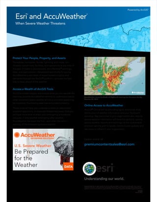
AccuWeather issues hundreds of SkyGuard warnings for Hurricane Sandy—
October 29, 2012.