Contenu connexe
Similaire à GeoPlanner for ArcGIS (20)
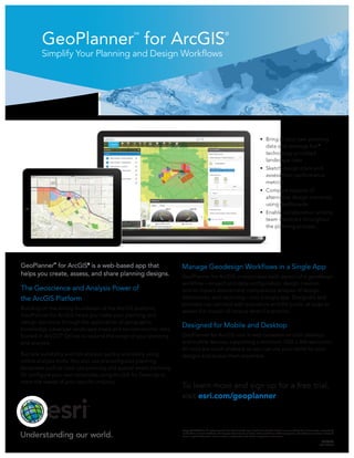
GeoPlanner for ArcGIS
- 1. GeoPlanner
SM
for ArcGIS
®
Simplify Your Planning and Design Workflows
Copyright © 2014 Esri. All rights reserved. Esri, the Esri globe logo, GeoPlanner, ArcGIS, and esri.com are trademarks, service marks, or registered
marks of Esri in the United States, the European Community, or certain other jurisdictions. Other companies and products or services mentioned
herein may be trademarks, service marks, or registered marks of their respective mark owners.
G64796
ESRI1M7/14tk
GeoPlanner
SM
for ArcGIS®
is a web-based app that
helps you create, assess, and share planning designs.
The Geoscience and Analysis Power of
the ArcGIS Platform
Building on the strong foundation of the ArcGIS platform,
GeoPlanner for ArcGIS helps you make your planning and
design decisions through the application of geographic
knowledge. Leverage landscape maps and socioeconomic data
hosted in ArcGIS
SM
Online to expand the range of your planning
and analysis.
Run site suitability and risk analysis quickly and easily using
online analysis tools. You also use preconfigured planning
templates such as land-use planning and special event planning.
Or configure your own templates using ArcGIS for Desktop to
meet the needs of your specific industry.
• Bring in your own planning
data and leverage Esri®
technology-provided
landscape data
• Sketch design plans and
assess their performance
metrics
• Compare impacts of
alternative design scenarios
using dashboards
• Enable collaboration among
team members throughout
the planning process
Manage Geodesign Workflows in a Single App
GeoPlanner for ArcGIS incorporates each aspect of a geodesign
workflow—project and data configuration, design creation
and its impact assessment, comparative analysis of design
alternatives, and reporting—into a single app. Designers and
planners can connect with evaluators and the public at large to
assess the impact of various what-if scenarios.
Designed for Mobile and Desktop
GeoPlanner for ArcGIS runs in web browsers on both desktop
and mobile devices, supporting a minimum 1024 x 768 resolution.
All tools are touch enabled, so you can use your tablet for your
designs and access them anywhere.
To learn more and sign up for a free trial,
visit esri.com/geoplanner.