Watershed Lab 2013
•Télécharger en tant que PPT, PDF•
1 j'aime•4,643 vues

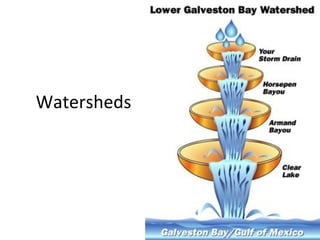
A watershed is defined as the land area that drains into a particular water body. During rainstorms, water flows over land as runoff and collects in streams, rivers, and other channels, with the entire land area draining into these waterways comprising the watershed. Watersheds resemble branching tree patterns as tributaries flow into streams and streams join together to form larger rivers. Pollutants from cities, factories, roads, and other sources are carried by runoff during rainstorms and drain into waterways, mixing together as they flow through the watershed from higher to lower elevations.

Recommandé
Contenu connexe
Similaire à Watershed Lab 2013
Similaire à Watershed Lab 2013 (17)
Plus de Jenny Dixon
Plus de Jenny Dixon (20)
Dernier
Dernier (20)
Watershed Lab 2013
- 1. Watersheds
- 2. What is a watershed? The land area that drains into a particular water body. All land is in a watershed and everybody lives in a watershed. During a rainstorm, the water that flows over the land as runoff collects in channels such as streams, canals, rivers, etc. The land area that drains water is called a watershed.
- 3. From an aerial view, drainage patterns in a watershed resemble a network similar to the branching pattern of a tree. Tributaries, flow into streams. Streams eventually empty into a large rivers. Like other branching patterns (e.g. road maps, veins in a leaf, the human nervous system), the drainage pattern consists of smaller channels merging into larger ones.
- 5. So why do we worry about water so much?
- 6. 1. Divide the paper into 4 parts. Each student will draw a town in their quadrant. Connect the towns with roads and railways. Add one lake. towns are red/orange/pink train tracks are brown roads are black lake is blue
- 7. 2. Take the sheet of paper and crumple it. 3. Next, partially smooth it out. It should look like a model of hills, some ridges and mountains. This represents your watershed. towns are red/orange/pink train tracks are brown roads are black
- 8. 4. Use the markers to color along the edge of the creases. You may want to use different colors to represent a variety of pollutants, such as fertilizer, oil, pesticides, litter, etc. 5. Lay the paper out on the plastic and shape it so that it looks like a watershed. 6. Use the creased lines to show elevated land areas. Use the skittles to place factories on your map. Place them near a road or railroad.
- 9. 7. Write your hypothesis. What do you think will happen in your watershed when it begins to rain? If it begins to rain in my watershed, then ….. Be specific! 8. Use the bottle of water and gently spray the top of the watershed. Keep spraying the paper until the colors begin to flow.
- 10. Pre-AP – Write at least 5-7 sentences in your paragraph. Science I – Write at least 3-5 sentences in your paragraph. 9. Describe what happened at the lowest point of the watershed. Did your pollutants remain separated? What happened near the towns, factories, roads, etc. Did the different pollutants mix together? If so, where did this happen in the watershed? Where would you want to build a house in this watershed? Where would you want it to be in relationship to your factory and cities?
- 13. Areas of higher elevation called divides separate watersheds from each other. Water flows through a series of channels and eventually it collects in a wide river that empties into a body of water such as an ocean or lake. Water flows from areas of higher elevation to lower elevatio
- 14. How do pollutants enter the water supply? Urban development removes vegetation and replaces it with buildings, streets, walkways, and driveways, thus preventing water from infiltrating the soil.