SlideShare une entreprise Scribd logo
1  sur  1
Télécharger pour lire hors ligne
Slide Hazards Scoring
Universiteit van Amsterdam
Assessing Environmental Vulnerability On the Inner
Caldera Slopes and Llano Basin Areas Within the El
Teide National Park by Evaluating Abiotic and Biotic
Parameters Using Field Data, GIS, and Remote Sensing.

Contenu connexe

Plus de Greg Burton

chapman_annexation_15_17_letter3
chapman_annexation_15_17_letter3chapman_annexation_15_17_letter3
chapman_annexation_15_17_letter3Greg Burton
 
chapman_annexation_15_17_letter2
chapman_annexation_15_17_letter2chapman_annexation_15_17_letter2
chapman_annexation_15_17_letter2Greg Burton
 
chapman_mulbery_may2015
chapman_mulbery_may2015chapman_mulbery_may2015
chapman_mulbery_may2015Greg Burton
 
chico_homeless_analysis_031107
chico_homeless_analysis_031107chico_homeless_analysis_031107
chico_homeless_analysis_031107Greg Burton
 
butte_county_weeds03
butte_county_weeds03butte_county_weeds03
butte_county_weeds03Greg Burton
 
cotopaxi_analysis01
cotopaxi_analysis01cotopaxi_analysis01
cotopaxi_analysis01Greg Burton
 
ecuador_map_final01
ecuador_map_final01ecuador_map_final01
ecuador_map_final01Greg Burton
 
CACLU_september_newsletter_electronica
CACLU_september_newsletter_electronicaCACLU_september_newsletter_electronica
CACLU_september_newsletter_electronicaGreg Burton
 
public_hearing02
public_hearing02public_hearing02
public_hearing02Greg Burton
 

Plus de Greg Burton (20)

chapman_annexation_15_17_letter3
chapman_annexation_15_17_letter3chapman_annexation_15_17_letter3
chapman_annexation_15_17_letter3
 
chapman_annexation_15_17_letter2
chapman_annexation_15_17_letter2chapman_annexation_15_17_letter2
chapman_annexation_15_17_letter2
 
chapman_mulbery_may2015
chapman_mulbery_may2015chapman_mulbery_may2015
chapman_mulbery_may2015
 
township_view1
township_view1township_view1
township_view1
 
chico_homeless_analysis_031107
chico_homeless_analysis_031107chico_homeless_analysis_031107
chico_homeless_analysis_031107
 
butte_county_weeds03
butte_county_weeds03butte_county_weeds03
butte_county_weeds03
 
report_final
report_finalreport_final
report_final
 
topography
topographytopography
topography
 
cotopaxi_analysis01
cotopaxi_analysis01cotopaxi_analysis01
cotopaxi_analysis01
 
ecuador_map_final01
ecuador_map_final01ecuador_map_final01
ecuador_map_final01
 
geology
geologygeology
geology
 
HACKR25A
HACKR25AHACKR25A
HACKR25A
 
CACLU_september_newsletter_electronica
CACLU_september_newsletter_electronicaCACLU_september_newsletter_electronica
CACLU_september_newsletter_electronica
 
hecho_mapa
hecho_mapahecho_mapa
hecho_mapa
 
PTO_SEA00040
PTO_SEA00040PTO_SEA00040
PTO_SEA00040
 
county_weeds01
county_weeds01county_weeds01
county_weeds01
 
public_hearing02
public_hearing02public_hearing02
public_hearing02
 
GREG
GREGGREG
GREG
 
bidwell_soils1
bidwell_soils1bidwell_soils1
bidwell_soils1
 
3D_map
3D_map3D_map
3D_map
 

hazards_scoring

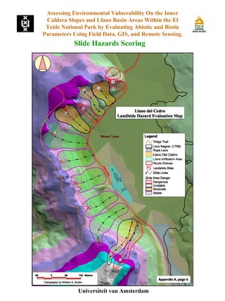
  • 1. Slide Hazards Scoring Universiteit van Amsterdam Assessing Environmental Vulnerability On the Inner Caldera Slopes and Llano Basin Areas Within the El Teide National Park by Evaluating Abiotic and Biotic Parameters Using Field Data, GIS, and Remote Sensing.