
Recommandé
Contenu connexe
En vedette
En vedette (20)
rev5_hfl_archs
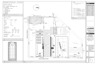
- 1. 150.14' S 11°35' 30" E 50.00' S 12°15' 00" E 125.36' N74°29'30"E 29.80' S65°20'00"W 183.95' N 12°15' 00" W 50.00' S77°45'30"W 250.00' S77°45'30"E 297.87' N 31°25' 00" E 111.43' S 12°15' 00" E 50.00' S77°45'00"W 200.00' S77°45'30"E INTERSECTIONSTREET NORTH FRANKLIN STREET NORTH 140.00' S 12°15' 00" E 60.00' N 12°15' 00" W 60.00' S 12°15' 00" E SETBACK SETBACK SETBACK
- 2. 150.14' S 11°35' 30" E 50.00' S 12°15' 00" E 125.36' N74°29'30"E 29.80' S65°20'00"W 183.95' N 12°15' 00" W 50.00' S77°45'30"W 250.00' S77°45'30"E 297.87' N 31°25' 00" E 111.43' S 12°15' 00" E 50.00' S77°45'00"W 200.00' S77°45'30"E INTERSECTIONSTREET NORTH FRANKLIN STREET NORTH 140.00' S 12°15' 00" E 60.00' N 12°15' 00" W 60.00' S 12°15' 00" E SETBACK SETBACK SETBACK
- 6. HEMPSTEAD