1. T
T
T
T
T
T
T
T
T
T
TT
T
T
T
T
T
T
T
T
T
T
TTT
TT
T
T
T
T
T
T
T
TT
T
T
T
T
T
T
TT
T
TTT
T
T
T
T
T
T
T
T
T
T
T
T
T
TT
T
T
!A
!A
!A
!A
!A
!A
!A
!A
!A
!A
!A
!A
!A !A
!A
!A
!A !A
!A
!A
!A
!A
!A
!A
!A
!A
!A
Erigan
C
hannel
Lake Erie
New York State
U.S.A.
Lake Ontario
Chippawa/Niagara Falls
Crystal Beach
G
roundw
ater flow
direction
W0000080
W0000287
Road9
Tyneside
Smith Road
Swayze Road
Haldibrook Road
St. David's Buried Gorge
£¤QEW
£¤6
£¤405£¤406
£¤3
£¤20
£¤58
£¤140
£¤58A
£¤420
£¤QEW
£¤3
£¤6
£¤3
£¤3
£¤3
£¤58
King Street
VictoriaAvenue
Canborough Road
Regional Road 27
Mud Street
Regional Road 20
Silver Street
Fly Road
York Road
SmithvilleRoad
Forks Road30Road
RegionalRoad56
MillerRoad
Dominion Road
Bowen Road
4th Avenue
Line 3
KalarRoad
Webber Road
Canboro Road
StanleyAvenue
HutchinsonRoad
SodomRoad
Lakeshore Road
Niagara
Stone
Road
Netherby Road
Line 5
Haldimand Road 9
Binbrook Road
Highway56Haldimand
WilhelmRoad
Carlton Street
MarshaganRoad
Regional Road 45
TynesideRoad
WoodburnRoad
North Shore Drive
WellandportRoad
Gilmore Road
JordanRoad
GenevaStreet
Haldimand Road 66
MoyerRoad
StevensvilleRoad
Ridge Road West
8th Avenue
Mud Street East
MontroseRoad
NiagaraStreet
Main Street West
ParkRoadSouth
Schisler Road
Killaly Street East
Erie Road
York Street
GorhamRoad
NiagaraParkway
Sherkston Road
DorchesterRoad
LakeStreet
DoansRidgeRoad
Lyons Creek Road
LouthStreet
Dickenson Road East
5thStreetLouth
Glendale Avenue
StPaulAvenue
SouthPelhamRoad
Mcleod Road
HelenaStreet
Phipps Street
Ridge Road
SchihlRoad
M
ain
Street
Regional Road 20
NiagaraStreet
KingStreet
Silver Street Regional Road 20
FH3-D
Welland
OakHall
College
Buchner
Townline
Monument
Glendale
CaseBell
GentsRoad
5thStreet
PublicWorks
GlynnAGreen
Concession1
BadenPowell
Stevensville
Gainsborough
YoungMatthews
SumblerCentre
Salina
Guelph
Lockport
Queenston
Bertie Onondaga
Bois Blanc
Clinton-Cataract Group
Humberstone Landfill
Line 5 Landfill
Winger Road Landfill
Station Road Landfill
Perry Road Landfill
W e s t L i n c o l nW e s t L i n c o l n
H a l d i m a n dH a l d i m a n d
H a m i l t o nH a m i l t o n
W a i n f l e e tW a i n f l e e t
L i n c o l nL i n c o l n
F o r t E r i eF o r t E r i e
P e l h a mP e l h a m
N i a g a r a F a l l sN i a g a r a F a l l s
T h o r o l dT h o r o l d
W e l l a n dW e l l a n d
P o r t C o l b o r n eP o r t C o l b o r n e
G r i m s b yG r i m s b y
S t . C a t h a r i n e sS t . C a t h a r i n e s
N i a g a r a - o n - t h e - L a k eN i a g a r a - o n - t h e - L a k e
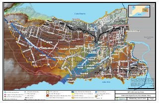
NPCA Monitoring Wells
Ontario Geological Survey Groundwater Study
!A NPCA Monitoring Wells
!A Niagara College Monitoring Well
!A NPCA 2015 Monitoring Wells
!A Select PGMN Wells
International Boundary
Major Highways
Major Roads
T Escarpment
5 m Bedrock Topography Contours
NPCA Jurisdiction
Municipal Boundaries
Niagara Region Waste Management Sites
Fonthill Kame Delta Complex
Upper Welland River Watershed
Bedrock Outcrop (<1m overburden)
Bedrock Geology
Bedrock Topography Below Lake Erie
Bedrock Valleys
Bedrock Topography (MASL)
High : 220
Low : 48
Lake Erie
Lake Ontario
Lake
Huron
Wednensday, June 17, 2015
¯
1:230,000
0 4 8 12 16
Km
Disclaimer: This map is intended for illustrative purposes
only. All Frames: North American Datum 1983, Universal
Transverse Mercator 6<SUP>o</SUP> Projection, Zone
17N, Central Meridian 81<SUP>o</SUP> West. Produced
by the Niagara Peninsula Conservation Authority with data
supplied under licence by members of the Ontario
Geospatial Data Exchange, 2012.
Updated 2014 & 2015.
Prepared by:
P.M.