2024: Domino Containers - The Next Step. News from the Domino Container commu...
Review 10 meteorology_sc
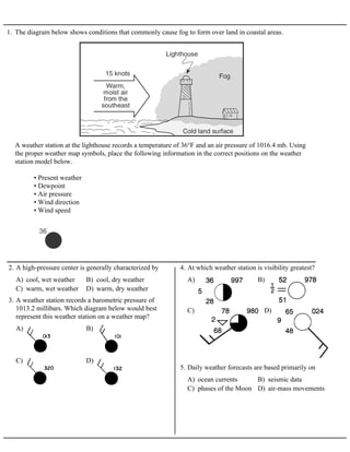
1. 1. The diagram below shows conditions that commonly cause fog to form over land in coastal areas.
A weather station at the lighthouse records a temperature of 36°F and an air pressure of 1016.4 mb. Using
the proper weather map symbols, place the following information in the correct positions on the weather
station model below.
• Present weather
• Dewpoint
• Air pressure
• Wind direction
• Wind speed
A) cool, wet weather B) cool, dry weather
C) warm, wet weather D) warm, dry weather
2. A high-pressure center is generally characterized by
A) B)
C) D)
3. A weather station records a barometric pressure of
1013.2 millibars. Which diagram below would best
represent this weather station on a weather map?
A) B)
C) D)
4. At which weather station is visibility greatest?
A) ocean currents B) seismic data
C) phases of the Moon D) air-mass movements
5. Daily weather forecasts are based primarily on
2. 6. The photograph below shows a spiral pattern of clouds in
the Earth's atmosphere. The spiral is hundreds of miles
across.
A) a cyclone
B) a cold front
C) a stationary front
D) a high-pressure center
Which type of weather does this photograph show?
7. The diagram below represents a cross section of air masses and frontal surfaces along line AB. The dashed
lines represent precipitation.
A) B)
C) D)
Which weather map best represents this frontal system?
3. 8. The map below shows the boundary between two air
masses. The arrows show the direction in which the
boundary is moving.
A) B)
C) D)
Which weather map uses the correct weather front
symbol to illustrate this information?
9. The following weather data was collected at Boonville, New York.
On the station model provided above, using the proper format, record:
• the amount of cloud cover
• the barometric pressure
• the symbol for the present weather
4. A) 914.6 mb of pressure and smog
B) 914.6 mb of pressure and a clear sky
C) 1014.6 mb of pressure and smog
D) 1014.6 mb of pressure and a clear sky
10. Various weather conditions at LAX Airport in Los
Angeles are shown on the station model below.
What were the barometric pressure and weather
conditions at the airport at the time of the observation?
A) mP B) mT C) cP D) cT
11. On a weather map, an airmass that is very warm and
dry would be labeled
A) mP B) mT C) cP D) cT
12. An air mass that originates over the northern Pacific
Ocean and moves southward over the United States
would most likely be labeled on a weather map as
A) B)
C) D)
13. Which weather-station model shows an air pressure of
993.4 millibars?
A) anemometer B) wind vane
C) psychrometer D) thermometer
14. Which weather instrument is used to measure wind
speed?
A) -5ºC dewpoint and 33% relative humidity
B) -5ºC dewpoint and 45% relative humidity
C) 4ºC dewpoint and 33% relative humidity
D) 4ºC dewpoint and 45% relative humidity
15. A parcel of air has a dry-bulb temperature of 16ºC and a
wet-bulb temperature of 10ºC. What are the dewpoint
and relative humidity of the air?
A) Humidity is decreasing.
B) Temperature is decreasing.
C) Skies are clearing.
D) A storm is approaching.
16. Which weather change is most likely indicated by
rapidly falling air pressure?
A) humidity differences
B) air pressure differences
C) the revolution of Earth
D) the rotation of Earth
17. What is the primary cause of winds?
A) the atmosphere is relatively dry
B) the air is at its saturated vapor pressure
C) the air pressure is high
D) transpiration equals evaporation
18. The relative humidity is 100% when
5. 19. Base your answer to the following question on The diagram below shows the temperature readings on a
weather instrument.
A) 8% B) 11% C) 32% D) 60%
Based on these readings, the relative humidity of the air is closest to
A) B)
C) D)
20. Which weather station model indicates the highest
relative humidity?
A) 20% B) 35% C) 50% D) 65%
21. What is the approximate relative humidity if the
dry-bulb temperature is 11ºC and the dewpoint
temperature is 1ºC?
6. 22. Base your answer to the following question on the diagram below, which shows a coastal region in which
the land slopes toward the ocean. Point X is near the top of the hill, point Y is at the base of the hill, and
point Z is a location at sea level. The same type of surface bedrock underlies this entire region. A stream
flows from point X through point Y to point Z. This stream is not shown in the diagram.
A) greater, since the slope of the land decreases
B) greater, since the slope of the land increases
C) less, since the slope of the land decreases
D) less, since the slope of the land increases
Compared to the stream velocity between point X and point Y, the stream velocity between point Y and
point Z is most likely
A) low permeability and gentle slope
B) low permeability and steep slope
C) high permeability and gentle slope
D) high permeability and steep slope
23. Which soil conditions normally result in the greatest
amount of runoff?
A) steep slope, heavy rain, and frozen ground
B) steep slope, gentle rain, and unfrozen ground
C) gentle slope, heavy rain, and frozen ground
D) gentle slope, gentle rain, and unfrozen ground
24. Which conditions produce the most surface water
runoff?
A) gentle slope and permeable surface
B) gentle slope and impermeable surface
C) steep slope and permeable surface
D) steep slope and impermeable surface
25. Which set of conditions would produce the most runoff
of precipitation?
A) small soil particles and a steep slope
B) small soil particles and a gentle slope
C) large soil particles and a steep slope
D) large soil particles and a gentle slope
26. The greatest amount of filtration occurs when the
surface of a permeable soil has
A) steep slope and permeable soil
B) steep slope and impermeable soil
C) gentle slope and permeable soil
D) gentle slope and impermeable soil
27. Which surface soil conditions allow the most
infiltration of rainwater?
A) gentle slope, saturated soil, no vegetation
B) gentle slope, unsaturated soil, vegetation
C) steep slope, saturated soil, vegetation
D) steep slope, unsaturated soil, no vegetation
28. Which set of surface soil conditions on a hillside would
result in the most infiltration of rainfall?
7. 29. Base your answer to the following question on the contour map of an island below. Points A through G
represent locations on the island. Elevations are in meters.
A) F B) B C) C D) D
Which point is located on the steepest slope?
A) less infiltration and more runoff
B) less infiltration and less runoff
C) more infiltration and more runoff
D) more infiltration and less runoff
30. Compared to an area of Earth's surface with gentle
slopes, an area with steeper slopes most likely has
A) permeable and saturated
B) permeable and unsaturated
C) impermeable and saturated
D) impermeable and unsaturated
31. Assuming a constant land slope, the greatest infiltration
of water into the Earth will occur when the surface is
32. Base your answer to the following question on The
diagram below shows two identical containers filled
with uniform particles that were sorted by size.
A) infiltration rate B) water retention
C) capillarity D) porosity
Which characteristic is most likely the same for these
particle-filled containers?
33. The diagram below represents two identical containers
filled with samples of loosely packed sediments. The
sediments are composed of the same material, but differ
in particle size. Which property is most nearly the same
for the two samples?
A) infiltration rate B) porosity
C) capillarity D) water retention