2. 1158 19.8 Indonesia
Indonesia, but waves generated by such disturbances are platforms and coral reefs. These are seen along the south-
occasionally transmitted into Indonesian waters, espe- ern shores of Sumatra and Java, in western and northern
cially along the southern coasts. Sulawesi (including Gorontalo Province), on the south
Tidal movements result from impulses that arrive coasts of the eastern islands and in the north of Irian Jaya.
from the Pacific Ocean by way of the South China Sea and Limestone cliffs, in particular, show the effects of intense
the Philippine Sea and from the Indian Ocean through the physical, chemical and biological weathering, with notches
Straits of Molucca and along the southern coasts to the and caves.
Timor and Arafura seas. Mean maximum tide ranges Beaches are extensive in Indonesia, some derived from
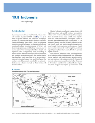
( Fig. 19.8.2) are generally less than 2 m and only exceed fluvial sands and gravels, others from cliff erosion and still
6 m locally on the southwest coast of Irian Jaya. Tides are others from the erosion of calcareous material from fring-
complicated by wind action, especially in the trade wind ing coral reefs. Beach sediment derived from volcanic
zones, and by the effects of tectonic and volcanic distur- rocks are typically black or grey; those of coralline origin
bances that generate tsunamis. The explosive eruption of are white or yellow. In the granitic zone of the Riau,
Krakatau in Sunda Strait in 1883 generated a tsunami up Bangka and Belitung Islands, white quartz sands domi-
to 30 m high on adjacent coasts and lesser surges all nate beaches. Sandy backshores are colonised by coastal
around the Indonesian coastline. Tectonic tsunamis some- vegetation, notably Ipomoea pes-caprae and Spinifex lit-
times res-hape the coasts in the subduction zones and may toreus, then coconut and casuarina trees. Coastal dunes
also near faults in the internal waters of Indonesia, as on are poorly developed in the humid tropics, but on the
Maumere and the surrounding islands, notably Babi southern shores of Java and Sumatra, prograded beaches
Island. The Boxing Day 2004 earthquake south of Sumatra are backed by dunes, some of which carry woodland
generated a large tsunami that caused extensive damage vegetation.
and sea flooding, particularly in Aceh province, and Some parts of the Indonesian coast have prograded
another earthquake in March 2005 caused uplift and sub- by the deposition of lava and ash from volcanic eruptions,
sidence on Nias and nearby islands south of Sumatra. as in the Krakatau Islands. Large quantities of pyroclas-
High parts of the coast are generally steep and forested tic sediment have been transported down to the coast
rather than cliffed, but where there is relatively strong from active volcanoes, such as Merapi in southern Java or
wave action (including swell) from the Indian Ocean or Agung in Bali, and from the erosion of dormant or extinct
the Philippine Sea, there are bold cliffs, fronted by shore volcanoes as on Manado Tua Island north of Menado.
Fig. 19.8.2
Variations in tide range around the Indonesian archipelago. (Courtesy Geostudies.)
1.2 0 500 1000km
1.4
1.9 N
0.4
2.0
0.4
3.8 2.5 CELEBES
0.4
0.6 2.2 2.8 SEA
2.2
S
0.6 1.7 1.8
U
1.1
M
0.8 0.9 1.5 1.7
A
1.0
T
1.9 0.7 0.8 0.6 1.2 1.3 1.4
R
KALIMANTAN 0.9
A
1.0 2.2 0.9 1.2 1.0
1.5 2.4 MOLUCCAS 0.7
0.9 1.6
2.1 0.7 0.9 0.8 0.6
1.5 SULAWESI0.4
1.0 0.8 1.7 0.6 1.0 IRIAN
0.8 1.0 1.4 1.4 JAYA
0.7 1.5 1.0
1.7
0.5 0.6J A V A SEA
0.5 0.5 1.9
1.0 0.8 0.9 BANDA SEA
0.4 1.4 1.5 2.6
IN 0.9 0.4 0.6 0.5
DO 1.2 4.2
1.1 JAVA 5.4
NE 1.7 1.1 FLORES SEA
SI 1.5 0.6 1.0 1.5 1.6
1.4 3.4
AN 1.8
1.5 1.0 1.2 2.4 2.6 O R 2.0 ARAFURA SEA
TIM
0.7 2.1
OC 2.0
EAN 2.8
2.0
TIMOR SEA 5.5
MEAN SPRING TIDE RANGE 1.7 1.9
(metres) 6.4 5.7 AUSTRALIA
6.6
10.5 1.1
3. Indonesia 19.8 1159
Apart from volcanic sources, rivers draining mountainous the opinion that the higher Holocene stillstand, well
uplands of conglomerate, sandstone and shale have car- documented on the east coast of peninsular Malaysia,
ried gravel, sand, silt and clay to the coast to form deltas could also be traced through much of Indonesia. During
and coastal plains as in East Sumatra, North Java, the Last Glacial low sea level phase, Java, Sumatra and
Kalimantan and Irian Jaya. Kalimantan occupied an enlarged Malaysian peninsula,
Prograded coasts are commonly marked by multiple separated by deep straits from Sulawesi and the eastern
beach ridges alternating with swales, as on the central islands, Australia then being linked to New Guinea. On
south coast of Java. Many features of coastal topography Timor and Atauro, stairways of emerged coral terraces
are related to the effects of deep weathering under humid have been dated and related to land uplift at rates of up to
tropical conditions: there are steep vegetated coastal slopes 0.5 m per thousand years during the Late Quaternary sea
with recurrent slumping on deeply weathered rock out- level oscillations, and there are emerged reefs on Sumbawa
crops, with cliffs confined to occasional bedrock head- Islands.
lands, and extensive deltas have been built by rivers that
bring down an abundance of fine-grained sediment from
sloping hinterlands, as in eastern Sumatra, northern Java, 2. The Coasts of Indonesia
Kalimantan and the south of Irian Jaya.
At least 50 mangrove species are found in Indonesia, 2.1. Sumatra
and mangrove-fringed coasts are extensive, especially in
the northeast of Sumatra, alongside the estuaries of south- The western and southern coasts of Sumatra are mostly
ern Kalimantan, and in southern Irian Jaya. Mangrove steep and cliffed, with intervening lowlands dominated
swamps develop on mud rich in organic matter, which by beach ridge plains, as at Tapak Tuan, Sibolga, Padang
darkens the sediment. In densely populated areas, as in (Verstappen 1973), Padang Bai (Bengkulu) and Teluk
northern Java, the mangrove fringe has been largely Lampung. There are many pocket beaches that were
cleared to make way for brackish-water fishpond (tambak) formed and nourished with sediment from eroding cliffs,
construction. Coastal features have also been modified by rivers and fringing coral reefs, with some local shell con-
human activities where the sediment yield from rivers has tributions. Rivers are generally short compared with those
increased as the result of accelerated erosion in their flowing to the east (Malacca Strait) coast, and some
deforested and cultivated catchments. Some parts of descend over waterfalls on or inland from coastal cliffs.
Indonesia, however, have a semi-arid climate that results An anticlinorial mountain chain with associated volca-
in thin soils and exposed rock outcrops, as in Nusa noes runs NW–SE through the island, dissected by the
Tenggara Timur and Nusa Tenggara Barat. active Semangko fault system. It is bordered to the south
Coral reefs are widespread, except off the mouths of of Sunda Strait by the Java trench and other roughly paral-
rivers where the sea is freshened and made turbid by water lel submarine fault systems between the mainland of
and sediment discharge and where active volcanic activity Sumatra and the island arc of Sinabang, Nias and Mentawai,
has inhibited coral establishment. There are many reef- which have most of the cliff and bluffs along the southwest
fringed islands and reefs that enclose lagoons with central coast. There was local uplift and depression on these
islands, and true atolls, especially in the Flores and Banda islands, as well as tsunami submergence, during the March
Seas. The major barrier reefs and atoll reefs are the Great 2005 earthquake.
Sunda Reef, rising from the submerged shelf margin The rivers that flow northeast and east coasts to the
southeast of Kalimantan, the Takabonerate reef south of shallow Straits of Malacca have formed a broad deposi-
Sulawesi and the reefs that curve out toward the islands of tional lowland with extensive wetlands bearing fresh
Batu and Banyak off Sumatra. Algal rims are better devel- water forest in the upper coastal plain and mangrove
oped on reefs along the oceanic southern shores than in swamps in the lower coastal plain. Beach ridges have
the inner seas. Many small islands are formed by coral been found up to 150 km inland, and the coastline of the
reefs such as the Seribu Islands north of Jakarta or as reef- Jambi area has prograded by up to 75 km in the past cen-
fringed islands such as Karimunjawa Islands north of tury, narrowing to the southeastern tip of Sumatra to
Semarang. form lineaments. In Lampung Bay, mining of a coastal
The record of changing sea levels in Indonesia has hill has exposed the inner part of a volcanic neck as an
been complicated by uplift and subsidence of the land by artificial bluff.
Quaternary tectonic movements. There are terraces and The Peusangan Delta in northern Sumatra shows
former coastlines at various levels, and Tjia (1975) was of stages in growth and decay related to river capture. The
4. 1160 19.8 Indonesia
beheading of Djuli River by river capture was followed Growth of a longshore spit has partly enclosed a coastal
by erosion of its delta, while the pirate stream, the lagoon in Padang Bay. Sediment from an inflowing river
Peusangan River, built a new delta to the east in two has been deposited in the lagoon, and there has been
stages. Beach ridges enable the sequence of delta growth shoaling of the lagoon mouth, narrowed by the growth of
and decay to be traced ( Fig. 19.8.3). When the Batang the spit. The lagoon had been used as a port, and a long
Arau river in Padang was diverted to the south, the for- jetty was built to maintain the lagoon mouth, but this has
mer delta to the north was eroded, and the coastline had led to updrift accretion and downdrift erosion.
to be maintained by building revetments and sea walls. Emerged fringing reefs up to 3 m above sea level are
Erosion has also occurred on the Tapak Tuan coastal found on the Aceh coast and nearby islands south of
plain in Aceh Province. The Boxing Day 2004 tsunami Lampung Bay, and the shores of Semangka and Lampung
caused extensive sea flooding and structural damage in Bays, and along the coast of Sunda Strait, are strewn with
Aceh Province. wave-deposited coral boulders.
Farther south rivers such as the Rokan, Kampar, Parts of the mangrove coast are still prograding, but
Indragir and Musi-Banyuasin open to broad tidal estuar- some have been retreated, even on relatively protected
ies fringed with mangroves and occupied by low-lying coasts as in the Dumai area. In the large Rokan, Kampar
islands. Ports which were close to the sea in the fifteenth and Musi-Banyuasin estuaries, mangroves occupy low
century, such as Palembang and the more recent depositional islands, especially where there is protection
Bagansiapi-api, are now far upstream, indicating that there by offshore hilly islands. Within mangrove swamps, there
has been rapid coastal progradation. However, rapid clear- are crab mounds that rise several centimetres above the
ing and exploitation of the mangroves have led to erosion mud surface. Many mangrove swamps have been con-
on many parts of the coast, as at Musi-Banyuasin, and verted into intensive fish or shrimp ponds (tambak) that
deforestation has caused severe shore erosion in East no longer receive river-borne silt because the enclosing
Lampung. banks exclude flood waters.
Fig. 19.8.3
Changes near the mouth of the Peusangan River, northern Sumatra, following a river capture. Beach ridge patterns indicate
the trend of an old delta north of Bireuen and two stages in the development of a new delta to the east: At A, a lobe that
has been truncated by erosion. At B, a developing modern delta. (Courtesy Geostudies.)
5. Indonesia 19.8 1161
Rias are common in the Riau Islands, produced by the 2.2. Krakatau
Late Quaternary marine transgression invading the lower
parts of river valleys. They are generally mangrove fringed. Krakatau, an island volcano in Sunda Strait, erupted explo-
On Batam Island, Duriangkang Bay is one of several bays sively in 1883, leaving residual steep-sided islands
that have been enclosed by artificial dykes to form fresh ( Fig. 19.8.4), Panjang, Sertung and Rakata ( Fig. 19.8.5).
water reservoirs. Subsequently, a new volcano, Anak Krakatau, has formed
There has been tin mining in granitic areas on some of within the caldera ( Fig. 19.8.6).
the Riau islands, together with Singkep, Bangka and Beli- Sunda Strait is bordered by steep volcanic coasts, and
tung Islands, and quartzose waste has formed beaches, the effects of the 1883 eruption of Krakatau (Symons 1888)
spits and barriers and a small artificial island east of are still evident. The eruption left a caldera of irregular
Bangka. There has also been sand quarrying on these outline, 7 km in diametre and up to 250 m deep, which has
islands for export to Singapore and Malaysia as reclamation been modified by rapid recession of cliffs cut into soft
material. As a result, some of the small islands have disap- pumice on the residual islands, which are now forested.
peared, others have been intensively eroded, and many The 1883 tsunami destroyed reefs and mangrove
fringing coral reefs have been destroyed. The granitic swamps, and the large coral boulders that were thrown up
coasts are dominated by quartz sand beaches, while coasts on the shore have since been undercut by up to 35 cm by
on metasedimentary rocks have rocky cliffs and muddy shore weathering processes. By 1927 the new volcanic
shores. The island of Karimun, west of Singapore, has island, Anak Krakatau, had formed in the caldera, and was
granite-weathering features, including tors and rillenkar- expanding in area and growing in height. It reached a
ren, rising from deeply weathered mantles on coastal height of 198 m by 1983, and in 2000 it was about 230 m
slopes. high. It is dissected by deep gravelly gullies, and has coasts
Fig. 19.8.4
spit
The Krakatau Islands.
ng
g
(Courtesy Geostudies.)
e ro d in
ti
accre
Panjang
Sertung
sandy cusp Anak
Krakatau
cliff
cliff
cliff
iff
cl
lav
sandy cusp
af
cliff
low
Karang Serang
ff
cli
s
.
0m .
20 250 m
N
ll
wa
cli
caldera
ff
Rakata
cli
ff
0 1 2 3 4 5 km.
6. 1162 19.8 Indonesia
Fig. 19.8.5
The steep cliff on Rakata
is the wall of the crater
formed by the 1883
explosion. (Courtesy
Geostudies.)
Fig. 19.8.6
Anak Krakatau, the new
volcano developing in the
Krakatau caldera.
(Courtesy Geostudies.)
with promontories of lava ( Fig. 19.8.7) and cliffs cut in 200 km wide. The higher parts of the island are formed by
volcanic ash ( Fig. 19.8.8). Some plants and animals have a chain of active and dormant volcanoes that run along its
colonised the new island. length, and have supplied large quantities of sediment as a
result of frequent eruptions (as from the Merapi volcano),
or erosion of the volcanic mountains. The drainage divide
2.3. Java follows the chain of volcanic peaks. Other sedimentary or
volcanic mountains and hills also contribute large quanti-
Java is the most densely populated island of Indonesia. ties of sediment, aided by intensive humid tropical weath-
It extends about 1,000 km from west to east and is up to ering processes. Rainfall of up to 7,000 mm/year produces
7. Indonesia 19.8 1163
Fig. 19.8.7
Lava promontory of Anak
Krakatau. (Courtesy
Geostudies.)
Fig. 19.8.8
Cliffs cut into pyroclastic
deposits on the south
coast of Anak Krakatau.
(Courtesy Geostudies.)
continuous flow in many rivers that have deposited sedi- from fringing coral reefs by the 1883 tsunami and depos-
ment to form wide coastal plains and growing deltas. ited on the shore platform ( Fig. 19.8.9) and the coastal
Rapid deforestation, especially in mountainous areas, has plain. There are erratic boulders of volcanic agglomerate
intensified erosion of the land surface and increased the and breccia in addition to the coral blocks.
yield of sediment to rivers, some of which show channel On the north coast of Java, deltaic plains have been
and river mouth shoaling. built out into the relatively low wave-energy microtidal
The west coast of Java, between Anyer and Labu-han, Java Sea by sand and silt-laden rivers. During the past cen-
is mainly formed by an emerged fringing coral reef, the tury sectors around the mouths of rivers and canals have
seaward margin of which is being eroded in many places. prograded, while sectors no longer receiving fluvial sedi-
Coral boulders are widespread along the shore, swept in ment have been subject to erosion. In several cases, river
8. 1164 19.8 Indonesia
Fig. 19.8.9
Coral reef blocks
deposited on the shore at
Anyer, Java, by the 1883
tsunami. (Courtesy
Geostudies.)
Fig. 19.8.10
eroding 0 6 12 Km
N The Citarum delta,
northern Java, formerly
former river courses built a delta northward,
but this is eroding away
beach ridge
following a swing to the
northwest, where the
modern delta is develop-
C it ing. Dam construction
arum
upstream has reduced the
sediment yield here and
slowed delta growth.
(Courtesy Geostudies.)
mouths have been diverted either naturally like the following the completion of the Jatiluhur Dam upstream
Cimanuk in 1947 or as the result of the cutting of canals, in 1970 (Bird and Ongkosongo 1980). Erosion has dam-
as on Ciujung and Ciwandan deltas, initiating new delta aged shrimp ponds (tambak) that has been constructed
growth. near the delta margin.
The coastline of Jakarta Bay shows stages in delta pro- Northwest of Jakarta Bay are the coral reefs and cays
gradation, especially on the eastern shores around the of the Thousand Islands, many of which have changed
mouths of Citarum River distributaries. Earlier coastlines in outline during the past century. Some have enlarged
are traceable from patterns of beach ridges in the Jakarta by the accretion of sand on cays and shingle on north-
region and also in the deltaic plains to the east. In re- eastern (windward) ramparts; others show erosion or
cent years, the Citarum Delta has grown northwestward lateral displacements related to variations in the local
( Fig. 19.8.10) and erosion has become extensive on its wind regime. Some are subsiding, others are rising and
northern flank, partly because river outlets have migrated some have been eroded as the result of removal of shin-
westward and partly because sediment yield has diminished gle and coral.
9. Indonesia 19.8 1165
To the east of Jakarta, the Citarum, Cipunegara and The south coast of Java has cliffed promontories and
Cimanuk, with smaller intervening rivers, have built up a limestone cliffs, often fronted by shore platforms and fring-
major confluent deltaic plain. The Cimanuk has built a ing reefs. The limestone cliffs have basal notches and visors
new delta following its diversion northeastward during a behind the shore platforms ( Fig. 19.8.11), and as these
flood in 1947. There has been subsequent growth along are as well developed on the lee shores of stacks and islands
three distributaries, with further branching developing as that have been shaped largely by solution processes.
the result of median shoal formation in the river mouths. Sand supplied by rivers has been deposited to form
The older delta to the west is eroding away, as is the east- extensive beaches, with local cuspate forelands, as behind
ern flank, which curves out to a low-lying promontory, Nusa Barung Island and tombolos, as at Pangandaran. The
Cape Ujung. This was thought to be a relic of an earlier wide coastal plain near Yogyakarta is related to an abun-
subdelta, but there are no relics of former channels leading dant fluvial sediment yield from the steep hinterland,
in this direction. Another suggestion has been that it is including sand and gravel brought down by rivers from
related to a buried or nearshore reef structure, but no the Merapi volcano, particularly after eruptions, when
evidence exists for this either. The promontory occurs lahars flow down slopes and river discharge is torrential.
where an earlier beach ridge system was truncated by the Dark grey sand is delivered to river mouths and spread
present coastline. along the shore. Formation of protruding deltas of the
On the smaller deltas to the east (Bangkaderas, Bosok, kind seen in northern Java is prevented by relatively strong
Pemali, Comal and Bodri), Hollerwöger (1964) traced the wave action, the shoreline being almost straight past the
stages in historical evolution and noted an acceleration of mouths of several rivers, each of which shows westward
growth after 1920, related to increased sediment yield due deflection by longshore drifting produced by waves gener-
to clearance of forests on steep hinterlands and the intro- ated by southeasterly winds. To the west of Parangtritis,
duction of farming to these areas. In detail, there have the seaward margin consists of beach ridges and active
been sectors of advance and retreat related to the changing dunes up to 30 m high, driven inland by the southeasterly
locations of river mouths. Near Jepara a new delta formed winds. These dunes were evidently mobilised when their
at the mouth of a canal cut in 1892 to divert the outflow scrub and woodland cover were destroyed by sheep and
from the Kedung River, and the Solo delta has grown rap- goat grazing and the harvesting of firewood. They are quite
idly. There has been substantial progradation of the coastal anomalous in a humid tropical environment.
plains around Surabaya in recent centuries, narrowing On the south coast of Central Java the westward
Surabaya Strait, which shows tidal scour features indica- growth of longshore spits due to the oblique arrival of
tive of strong current action. waves generated by southeasterly winds may block river
Fig. 19.8.11
Notched coastal slope at
Baron, southern Java,
behind a shore platform
that has a veneer of black
volcanic sand. (Courtesy
Geostudies.)
10. 1166 19.8 Indonesia
Fig. 19.8.12
Beach ridges on the coastal plain east of Cilacap. (Courtesy Geostudies.)
SOUTH SERAYU RANGE
SOUTH SERAYU RANGE
1
N
Segara
Anakan 2
INDIAN OCEAN
Cilacap
NUSA KAMBANGAN
Uplands Beach ridges
Alluvium 1 Heavily silt-laden water
0 5 10km.
Wetlands 2 Slightly silt-laden water
Fig. 19.8.13
Segara Anakan, a mangrove-fringed lagoon. (Courtesy Geostudies.)
SEGARA ANAKAN
W E T L
y
A
ndu
N
D
m S
Cita
m
m m m
m
m m
m
Segara m m
m m
m m
m
Anakan m m m
m
m m m m
m m m
m m m
m m
m m m
m
m m m m
m Kali Kem m
bangkuni
ng
C. Cimangga Uplands CILACAP
Beach ridges C. Karang -
N
m Mangroves Nusa Kambangan bolong
Mangrove encroachment
1943 - 1976
0 5 10 km.
11. Indonesia 19.8 1167
mouths for some weeks or months during the dry season, where the tide range is more than 2 m, but the Mahakam
forming temporary coastal lagoons. The spits are usually has built a major delta ( Fig. 19.8.14) formed largely of
breached when river outflow increases in the wet season. coarse, sandy sediment derived from fluvial erosion of
The coast west to Cilacap has prograded intermittently, sandstone ridges near Samarinda, with swampy areas be-
with the addition of successive beach ridges which are tween the distributaries. On the west coast, only the Pawan
interrupted by alluvial tracts where rivers such as the Serayu and Kapuas rivers have carried sufficient sediment from
flow across them ( Fig. 19.8.12). At Cilacap the coastal their extensive catchments to build protruding deltas.
plain extends behind a high limestone ridge, and extensive
mangrove swamps, intersected by tidal channels and creeks,
border the broad, shallow estuarine lagoon of Segara 2.5. Sulawesi
Anakan. Inflow of large quantities of silt, especially from
the Citanduy River, is reducing the depth and extent of this Sulawesi has generally steep coasts, with terraces (includ-
lagoon system and promoting mangrove encroachment ing emerged, tilted, and warped coral reefs) up to 600 m
( Fig. 19.8.13). Farther west, sectors of steep coast alter- above sea level indicating tectonic uplift. Rivers are short
nate with beach-ridge plains along and towards Java Head, and steep, with waterfalls and incised gorges and only
at the southern entrance to Sunda Strait. minor depositional plains at their mouths. Volcanoes are
active locally, notably on Menadotua off the north of the
island.
2.4. Kalimantan
Geomorphologists have given very little attention to the 2.6. Madura
coasts of Kalimantan. Swampy plains are extensive, but
rates of progradation have not been documented. Many The island of Madura is notable for its straight northern
river mouths are estuarine, especially on the east coast coast which may follow a fault line.
Fig. 19.8.14
Morphological M A H A K A M D ELTA
features of the 0 5 10 15 20 km. 0°20 S
Mahakam delta Swamp Hilly ridges
Mud, sand 20 Fathom lines
on the east coast i
el
of Kalimantan. Ka
a
20
r
10
ua
The high-tide M
shoreline is
Soe
intricate and Muara llu
nga
Samarinda 0°30 S
dynamic, but the
i
delta really Ma
hak
am
extends seaward
as a submerged Muara Pantuan
sedimentary lobe
with a steep outer 0°40 S
slope, here
indicated by the Muara Bajor
10- and 20-fathom
lines. (Courtesy
Geostudies.)
M
ua
ra IT
10
20
Bu A 0°50 S
dj R
it T
S
Mu
ara
R
Muara Djaw
A
SS
Ul
A
K
u
A
M
117°00 E 117°10 E 117°20 E 10 117°30 E 117°40 E
a
20
12. 1168 19.8 Indonesia
Fig. 19.8.15
The limestone cliff at
Uluwatu on the southeast
coast of Bali. (Courtesy
Geostudies.)
Fig. 19.8.16
Fringing reef on the east
coast of Bali, backed by a
beach of coralline sand
derived from the reef.
(Courtesy Geostudies.)
2.7. Bali and partly of coralline limestone formations, which
are cliffed on the Bukit Peninsula to the southeast
Bali consists partly of volcanic terrain, with active volca- ( Fig. 19.8.15). Beaches border much of the island, with
noes such as Agung periodically generating lava and coral sands behind fringing reefs ( Fig. 19.8.16) con-
ash deposits that are washed down to the sea by rivers, trasting with dark grey sand derived from cliff outcrops
13. Indonesia 19.8 1169
of volcanic ash, or carried down to the sea by rivers 2.9. Lesser Sunda Islands
draining the volcanic terrain. The spit at Gilimanuk
shows evidence of alternating growth and truncation, Many of the features seen on Bali and Lombok are repeated
and in the Sanur area spits and barrier islands enclose a on the Lesser Sunda Islands to the east. High cliffs of
broad, mangrove-fringed tidal embayment north of the limestone and volcanic rock fringe the southern coasts of
sandy isthmus at Denpasar. Sumbawa, and Sumba, and active volcanoes have depos-
ited material on the coasts of Flores and Halmahera. Uplift
is indicated by emerged coral reefs, attaining 700 m on
2.8. Lombok Sumbawa and over 1,200 m on Timor, where the sequence
dated by Chappell and Veeh (1978) indicated uplift rates
The north coast of the island of Lombok has cliffs cut of up to 0.5 m per thousand years. Many of the smaller
in lava and ash from the Mount Rinjani volcano, and islands of eastern Indonesia are either high volcanic
off the east coast coral reefs are extensive in coastal islands or uplifted coralline structures of various kinds.
waters. Beaches are generally of dark grey volcanic sand,
often with coralline gravel, and backed by prograded
beach ridge plains. Off the northeast coast Gili Petangan, 2.10. Irian Jaya
Gili Sulat and Gili Lawang are sand cays on coral reefs,
the sandy beaches containing layers of beach rock The north coast of Irian Jaya is generally steep, but rivers
( Fig. 19.8.17), the cays having grassy and shrubby vege- have built deltas and beach-ridge plains. Evidence of con-
tation. On the south coast headlands of sandstone exposed tinuing tectonic activity is common: earthquakes cause
to ocean swell from the southwest are cliffed and fronted landslides on coastal slopes, and the Mamberamo Delta
by subhorizontal shore platforms produced by weathering has been modified by subsidence ( Fig. 19.8.18). The
down to the water table ( Fig. 19.8.18). There are broad south coast borders the broad, swampy lowlands traversed
prograded sandy beaches, especially behind coral reefs as by rivers that open into widening muddy estuaries with
at Kuta on the central south coast. strong tidal currents; tide ranges here are up to 6 m. The
Fig. 19.8.17
Beach rock on the shore
of Gili Petangan, Lombok.
(Courtesy Geostudies.)
14. 1170 19.8 Indonesia
Fig. 19.8.18
Zone of subsidence across the Mamberamo Delta in northern Irian Jaya, showing the Rombebai Lake formed as the land
subsided and the spread of mangroves back into the lowered area. (Courtesy Geostudies.)
Hollerwöger F (1964) The progress of the river deltas in Java. Scientific
rivers have not built protruding deltas, but deposition is problems of humid tropical zone deltas and their implications,
locally advancing the swampy shorelines. UNESCO, Paris, pp 347–355
Symons GJ (ed) (1888) The eruption of Krakatoa, and subsequent phe-
nomena. Royal Society, London
References Tjia HD (1975) Holocene eustatic sea levels and glacioeustatic rebound.
Z Geomorpholo Suppl.(Bd) 22:57–71
Bird ECF, Ongkosongo OSR (1980) Environmental changes on the coasts Verstappen H (1973) A geomorphological reconnaissance of Sumatra and
of Indonesia. United Nations University Press, Tokyo, Japan adjacent Islands. Wolters-Noordhoff, Groningen
Chappell J, Veeh HH (1978) Tectonic movements and sea level changes at
Timor and Atauro Island. Bull Geol Soc Amer 89:356–368