
Recommandé
Contenu connexe
Tendances
Tendances (20)
En vedette
En vedette (18)
Similaire à GIS Analysis of Coastal Management Strategies
Similaire à GIS Analysis of Coastal Management Strategies (20)
Dernier
Dernier (20)
GIS Analysis of Coastal Management Strategies
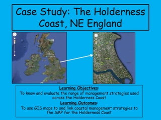
- 1. Case Study: The Holderness Coast, NE England Learning Objectives: To know and evaluate the range of management strategies used across the Holderness Coast Learning Outcomes: To use GIS maps to and link coastal management strategies to the SMP for the Holderness Coast
- 2. Tasks: 1. Match the words to the pictures. Use this to write a definition of the key term. 2. Decide which location the satellite image is showing. • Complete the table next to the map • Annotate the image: Positives and negatives of that type of management and why you think they selected to use it in that particular location 3. As a group use the work we have completed today, the resource and your knowledge of GIS to help brainstorm ideas to help answer the exam question. Case Study: The Holderness Coast, NE England
- 3. Tasks: 1. Match the words to the pictures. 2. Use this to write a definition of the key term. 3. Check the answers of the group next to you and make any relevant corrections Case Study: The Holderness Coast, NE England
- 4. Integrated coastal management: Shoreline Management Plan (SMP): Hold the Line: Advance the Line: Retreat the Line: Do Nothing:
- 6. Hornsea Mappleton / Great Cowden Withensea Easington Spurn Head Coastal Management along the Holderness Coast Task: Decide which location the satellite image is showing using the descriptions • Complete the table next to the map • Annotate the image: Positives and negatives of that type of management and why you think they selected to use it in that particular location Example: Skipsea
- 7. Example: Skipsea Location Skipsea SMP method Hold the line / Do nothing Management Gabions (cages of rock) Hard or Soft Engineering Hard (Gabions), Soft (do nothing) Gabion cages built by local landowner to protect caravan park Have been successful in stopping erosion Expensive, as landowner has only been able to afford to protect a small area Landowner has protected this area as the leisure park is worth the cost of the gabions. Not all is protected as the caravans can be moved away as the coast retreats Erosion either side of the gabions has continued Gabions are cheaper than sea walls and groynes, this has enabled a private landowner to pay for them
- 8. Hornsea Location SMP method Management Hard or Soft Engineering
- 9. Mappleton Location SMP method Management Hard or Soft Engineering
- 10. Withensea Location SMP method Management Hard or Soft Engineering
- 11. Easington Location SMP method Management Hard or Soft Engineering
- 12. Spurn Head Location SMP method Management Hard or Soft Engineering
- 13. Task: As a group use ideas form the work we have completed today, the resource and your knowledge of GIS to help brainstorm ideas to answer the exam question. Rotate your work and add at least one new idea to the work of other groups
- 15. Coastal management along the Holderness Coast? Integrated Coastal Management • Means that sections of the coast are managed as a whole, rather than by individual towns or villages. Coastal engineers now realise that actions in one place have effects in other areas. • Shoreline Management Plans (SMPs) are used to manage smaller sub cell area. All local interest groups are consulted before taking one of the following options. 1. Do Nothing: e.g. let existing defences collapse 2. Hold the Line: e.g. keep the coastline where it is by using hard engineering 3. Advance the Line: e.g. build coastal defences further out to sea – breakwaters 4. Retreat the Line: e.g. allow the coast to erode back to a defined line The SMP for the Holderness Coast is: • Hold the line in places of economic value – e.g. Gas pipe terminal at Easington and towns at Bridlington and Hornsea • Do nothing in areas where nothing is worth protecting from erosion. Unprotected areas will eventually from bays. These will become more sheltered, and erosion should stabilise What are the positives and negatives of Integrated Coastal Management
- 16. Coastal management along the Holderness Coast? Positives • Combines hard engineering (for places of economic value needing a strategy of hold the line) with soft engineering which is more sustainable and long term for areas of lower value or with valued eco- systems. • They manage the coastline (sediment cell) as a whole so consider any consequences of management schemes on different areas of the coastline. • They take into account the views of many local interest groups, so should be of benefit to most. Negatives • It can be difficult and time consuming to consult lots of different players, with different priorities. • Hard engineering (holding the line) is expensive and can be short term. • Holding the line in one place can have increased impacts in other areas. E.g. Mappleton – rock groynes leading to increased erosion in Great Cowden. • Managed retreat (do nothing) is often unpopular, it can be seen as an ‘easy opt out’ and can be politically difficult to execute. What are the positives and negatives of Integrated Coastal Management
- 17. May 2012