SlideShare une entreprise Scribd logo
1  sur  12
Télécharger pour lire hors ligne
DIGITAL CONSERVATION: DOUGALSTON DOOCOT!
Terrestrial Laser Scanning vs Photogrammetry
Peter McCready !
08065141
PRESENTATION OUTLINE
Peter McCready !
0806514
1. Project Overview
2. Deliverables
3. Study Area
4. Doocot - Interior and Exterior
5. Project Resources
6. Terrestrial Laser Scan
7. Photogrammetry
8. Comparison of Methodologies
2
PROJECT OVERVIEW
Peter McCready !
0806514
Provisional Project Title:
Digital building conservation: a comparative study of Terrestrial Laser Scanning and
Photogrammetry. A case study of the Dougalston Estate Doocot in Milngavie, Glasgow.
3
• Interior and exterior Terrestrial Laser Scan (TLS) of the Doocot
!
• Photogrammetry of a section of the Doocot
!
• Generate 3D models from TLS and Photogrammetry data
!
• Comparison of the two different methodologies
!
• Submission of a 3D model to the Royal Commission on the Ancient and
Historical Monuments of Scotland (RCAHMS) and provide model to local
heritage and history groups
Intentions:
1. Interior and exterior 3D model of the Doocot from TLS
(That will be submitted to RCAHMS)
!
2. 3D model of a section of the Doocot from Photogrammetry
!
3. Comparison of the two different methods and a recommendation
!
4. Lessons learned and recommendations for a future project
Peter McCready !
0806514
DELIVERABLES
4
STUDY AREA
Doocot
Peter McCready !
0806514
N
N
5
DOOCOT
Peter McCready !
0806514
Exterior
Visible Water Damage
Hardcast Removal?
Interior
Brick Degradation
Lantern Hole Covered
Ladder and Axle Removed from
Roof and Ground Housings
Gaps in Roof Woodwork
6
Peter McCready !
0806514
PROJECT RESOURCES
EQUIPMENT OFFICE HARDWARE PROCESSING SOFTWARE
LEICA 1200 STATIC GNSS COMPUTER LEICA GEOOFFICE 8.1
LEICA SCANSTATION C10 LASER SCANNER EXTERNAL HARD DRIVE LEICA CYCLONE 8.1
LEICA HDS 6” TARGETS USB DRIVE AGISOFT PHOTOSCAN
DSLR CAMERA CLOUD COMPARE (Open Source)
RTK GNSS AUTODESK 3DS MAX (Trial Version)
TRIPODS BLENDER (Open Source)
3m MEASURING TAPE (Instrument Heights)
WOODEN STATION PEGS
WAX PEN (To Mark Interior Station)
7
1. Control network setup!
- Static GNSS
- Check with RTK GNSS
2. HDS 6” target scanning (BS & FS)!
! - ! Adopting the Traverse Method!
3. Point cloud acquisition (Doocot Laser Scanning)!
4. Image acquisition (TLS Photography)!
5. Traverse to next station until complete!
6. Data cleaning & modelling
Peter McCready !
0806514
TLS PROCESS
8
Image Source: http://eca.state.gov/
Peter McCready !
0806514
TLS TRAVERSE
• 6-10 Exterior Scans (Currently Undecided)
• 1-3 Interior Scans (Currently Undecided)
• Station C used as Reference Point for Interior Traverse
9
C
H
G
I
INTERIOR!
TRAVERSEEXTERIOR TRAVERSE
1. Image capture!
2. Inspect image-set!
3. Photography processing - Structure From Motion (SFM)!
- Image alignment, camera calibration & camera positioning
- Feature point detection
- Feature monitoring
4. 3D point cloud generation!
5. Building Mesh (Geometry)!
6. Texturing
Peter McCready !
0806514
PHOTOGRAMMETRY PROCESS
10
Image Source: http://michot.julien.free.fr/
1. Methodology (equipment requirement, expense etc.)
2. Point Cloud Accuracy
3. Data Capture Time
4. Data Processing Time
Peter McCready !
0806514
TLS vs PHOTOGRAMMETRY
11
• Will add to the comparison criteria after further reading
Comparison Criteria:
Please Contact:!
!
Peter McCready - MSc Candidate
!
0806514m@student.gla.ac.uk
FURTHER INFORMATION
Peter McCready !
0806514
References:!
!
!
GREAT BRITAIN. Peter McGowan Associates (2006) Survey of Historic Gardens and Designed Landscapes in East
Dunbartonshire, East Dunbartonshire: East Dunbartonshire Council
!
UNITED STATES OF AMERICA. CALIFORNIA DEPARTMENT OF TRANSPORTATION. (2011) Caltrans Surveys Manual.
State of California: Office of Land Surveys
!
Verhoeven, G. (2011) Taking Computer Vision Aloft - Archaeological Three-Dimensional Reconstructions from Aerial
Photographs with PhotoScan, Wiley Online Library [Online] Archaeological Prospection 18 (1) p.67-73. Available from:
http://onlinelibrary.wiley.com/doi/10.1002/arp.399/full [Accessed: 7th May 2015]
12
THANK YOU!
ANY QUESTIONS?

Contenu connexe

Tendances

Overview of hyperspectral remote sensing of impervious surfaces
Overview of hyperspectral remote sensing of impervious surfacesOverview of hyperspectral remote sensing of impervious surfaces
Overview of hyperspectral remote sensing of impervious surfaceszhengspace
 
FDL 2017 Lunar Water and Volatiles
FDL 2017 Lunar Water and VolatilesFDL 2017 Lunar Water and Volatiles
FDL 2017 Lunar Water and VolatilesLeonard Silverberg
 
ground penetrating radar
ground penetrating radarground penetrating radar
ground penetrating radarGauravate
 
hyperspectral remote sensing and its geological applications
hyperspectral remote sensing and its geological applicationshyperspectral remote sensing and its geological applications
hyperspectral remote sensing and its geological applicationsabhijeet_banerjee
 
Sonnentag phenocams 2014
Sonnentag phenocams 2014Sonnentag phenocams 2014
Sonnentag phenocams 2014aceas13tern
 
LiDAR Introduction @ #DataWeekend
LiDAR Introduction @ #DataWeekendLiDAR Introduction @ #DataWeekend
LiDAR Introduction @ #DataWeekendcodefortomorrow
 
Ground Penetrating Radar
Ground Penetrating RadarGround Penetrating Radar
Ground Penetrating RadarVARUN KUMAR
 
thenkabail-uav-germany-final1b
thenkabail-uav-germany-final1bthenkabail-uav-germany-final1b
thenkabail-uav-germany-final1bPrasad Thenkabail
 
Comparison Of Elevation Collection Technologies
Comparison Of Elevation Collection TechnologiesComparison Of Elevation Collection Technologies
Comparison Of Elevation Collection TechnologiesPaulDavidShaw
 
Phd talk.mini
Phd talk.miniPhd talk.mini
Phd talk.minigf25
 
Presentation on the background theory of InSAR
Presentation on the background theory of InSARPresentation on the background theory of InSAR
Presentation on the background theory of InSARSERC at Carleton College
 
20041014 AIR-257: Satellite Detection of Aerosols Satellite Types
20041014 AIR-257: Satellite Detection of Aerosols Satellite Types20041014 AIR-257: Satellite Detection of Aerosols Satellite Types
20041014 AIR-257: Satellite Detection of Aerosols Satellite TypesRudolf Husar
 
Satellite Link Measurements
Satellite Link MeasurementsSatellite Link Measurements
Satellite Link Measurementsbjp4642
 
ground penetration rader
ground  penetration raderground  penetration rader
ground penetration raderAmir Khan
 
Detecting solar farms with deep learning
Detecting solar farms with deep learningDetecting solar farms with deep learning
Detecting solar farms with deep learningJason Brown
 
Geospatial Research At UCL
Geospatial Research At UCLGeospatial Research At UCL
Geospatial Research At UCLJeremy Morley
 
GROUND PENETRATING RADAR(GPR) ppt
GROUND PENETRATING RADAR(GPR) ppt GROUND PENETRATING RADAR(GPR) ppt
GROUND PENETRATING RADAR(GPR) ppt Himanshu Yadav
 

Tendances (20)

Pertemuan 1
Pertemuan 1Pertemuan 1
Pertemuan 1
 
PARABLE POSTER
PARABLE POSTERPARABLE POSTER
PARABLE POSTER
 
Overview of hyperspectral remote sensing of impervious surfaces
Overview of hyperspectral remote sensing of impervious surfacesOverview of hyperspectral remote sensing of impervious surfaces
Overview of hyperspectral remote sensing of impervious surfaces
 
FDL 2017 Lunar Water and Volatiles
FDL 2017 Lunar Water and VolatilesFDL 2017 Lunar Water and Volatiles
FDL 2017 Lunar Water and Volatiles
 
ground penetrating radar
ground penetrating radarground penetrating radar
ground penetrating radar
 
hyperspectral remote sensing and its geological applications
hyperspectral remote sensing and its geological applicationshyperspectral remote sensing and its geological applications
hyperspectral remote sensing and its geological applications
 
Sonnentag phenocams 2014
Sonnentag phenocams 2014Sonnentag phenocams 2014
Sonnentag phenocams 2014
 
FDL 2017 3D Shape Modeling
FDL 2017 3D Shape ModelingFDL 2017 3D Shape Modeling
FDL 2017 3D Shape Modeling
 
LiDAR Introduction @ #DataWeekend
LiDAR Introduction @ #DataWeekendLiDAR Introduction @ #DataWeekend
LiDAR Introduction @ #DataWeekend
 
Ground Penetrating Radar
Ground Penetrating RadarGround Penetrating Radar
Ground Penetrating Radar
 
thenkabail-uav-germany-final1b
thenkabail-uav-germany-final1bthenkabail-uav-germany-final1b
thenkabail-uav-germany-final1b
 
Comparison Of Elevation Collection Technologies
Comparison Of Elevation Collection TechnologiesComparison Of Elevation Collection Technologies
Comparison Of Elevation Collection Technologies
 
Phd talk.mini
Phd talk.miniPhd talk.mini
Phd talk.mini
 
Presentation on the background theory of InSAR
Presentation on the background theory of InSARPresentation on the background theory of InSAR
Presentation on the background theory of InSAR
 
20041014 AIR-257: Satellite Detection of Aerosols Satellite Types
20041014 AIR-257: Satellite Detection of Aerosols Satellite Types20041014 AIR-257: Satellite Detection of Aerosols Satellite Types
20041014 AIR-257: Satellite Detection of Aerosols Satellite Types
 
Satellite Link Measurements
Satellite Link MeasurementsSatellite Link Measurements
Satellite Link Measurements
 
ground penetration rader
ground  penetration raderground  penetration rader
ground penetration rader
 
Detecting solar farms with deep learning
Detecting solar farms with deep learningDetecting solar farms with deep learning
Detecting solar farms with deep learning
 
Geospatial Research At UCL
Geospatial Research At UCLGeospatial Research At UCL
Geospatial Research At UCL
 
GROUND PENETRATING RADAR(GPR) ppt
GROUND PENETRATING RADAR(GPR) ppt GROUND PENETRATING RADAR(GPR) ppt
GROUND PENETRATING RADAR(GPR) ppt
 

Similaire à MSc Proposal Presentation: A comparison of TLS and Photogrammetry

An Investigation of GNSS Techniques
An Investigation of GNSS TechniquesAn Investigation of GNSS Techniques
An Investigation of GNSS TechniquesPeter McCready
 
Long-Range Wireless Sensor Networks for Geo-location Tracking: Design and Eva...
Long-Range Wireless Sensor Networks for Geo-location Tracking: Design and Eva...Long-Range Wireless Sensor Networks for Geo-location Tracking: Design and Eva...
Long-Range Wireless Sensor Networks for Geo-location Tracking: Design and Eva...Ahmad Muzaffar Baharudin
 
Space Situational Awareness Forum - GERMAN AEROSPACE CENTRE Presentation
Space Situational Awareness Forum - GERMAN AEROSPACE CENTRE PresentationSpace Situational Awareness Forum - GERMAN AEROSPACE CENTRE Presentation
Space Situational Awareness Forum - GERMAN AEROSPACE CENTRE PresentationSpace_Situational_Awareness
 
Laser Scanning and 3-D Modeling of Jacobs Hall
Laser Scanning and 3-D Modeling of Jacobs HallLaser Scanning and 3-D Modeling of Jacobs Hall
Laser Scanning and 3-D Modeling of Jacobs HallQudsia Wahab, EIT
 
Multi Limn Leica Hds Conference 2009
Multi Limn   Leica Hds Conference 2009Multi Limn   Leica Hds Conference 2009
Multi Limn Leica Hds Conference 2009timbeach
 
기상위성 자료처리를 위한 Python 기반의 Pytroll 활용하기
기상위성 자료처리를 위한 Python 기반의 Pytroll 활용하기기상위성 자료처리를 위한 Python 기반의 Pytroll 활용하기
기상위성 자료처리를 위한 Python 기반의 Pytroll 활용하기park jinwoo
 
Integration of Aerial Imagery, LiDAR and TLS for modelling the Melbourne Cric...
Integration of Aerial Imagery, LiDAR and TLS for modelling the Melbourne Cric...Integration of Aerial Imagery, LiDAR and TLS for modelling the Melbourne Cric...
Integration of Aerial Imagery, LiDAR and TLS for modelling the Melbourne Cric...Monica Moran
 
Investigating GIS Technologies - Group 01CW Final Presentation
Investigating GIS Technologies - Group 01CW Final PresentationInvestigating GIS Technologies - Group 01CW Final Presentation
Investigating GIS Technologies - Group 01CW Final PresentationSimon Sweeney
 
D2 (A4) Cosmin Popescu - Remote bridge inspection using optical methods.pptx
D2 (A4) Cosmin Popescu - Remote bridge inspection using optical methods.pptxD2 (A4) Cosmin Popescu - Remote bridge inspection using optical methods.pptx
D2 (A4) Cosmin Popescu - Remote bridge inspection using optical methods.pptxSvenska Betongföreningen
 
Plandescil – Surveying
Plandescil – SurveyingPlandescil – Surveying
Plandescil – Surveyingplandescil
 
Terrestrial LiDAR and Photogrammetry; a Historic Site Comparative
Terrestrial LiDAR and Photogrammetry; a Historic Site ComparativeTerrestrial LiDAR and Photogrammetry; a Historic Site Comparative
Terrestrial LiDAR and Photogrammetry; a Historic Site ComparativeCOGS Presentations
 
Coastway SCAN to BIM Presentation may 25th cita
Coastway SCAN to BIM Presentation may 25th citaCoastway SCAN to BIM Presentation may 25th cita
Coastway SCAN to BIM Presentation may 25th citaCoastway
 
Coastway SCAN to BIM Presentation may 25th cita
Coastway SCAN to BIM Presentation may 25th citaCoastway SCAN to BIM Presentation may 25th cita
Coastway SCAN to BIM Presentation may 25th citaCoastway
 
Data quality evaluation & orbit identification from scatterometer
Data quality evaluation & orbit identification from scatterometerData quality evaluation & orbit identification from scatterometer
Data quality evaluation & orbit identification from scatterometerMudit Dholakia
 
ESCAPE Kick-off meeting - KM3Net, Opening a new window on our universe (Feb 2...
ESCAPE Kick-off meeting - KM3Net, Opening a new window on our universe (Feb 2...ESCAPE Kick-off meeting - KM3Net, Opening a new window on our universe (Feb 2...
ESCAPE Kick-off meeting - KM3Net, Opening a new window on our universe (Feb 2...ESCAPE EU
 
Skyline, azimuth and altitude tools for archaeoastronomy
Skyline, azimuth and altitude tools for archaeoastronomySkyline, azimuth and altitude tools for archaeoastronomy
Skyline, azimuth and altitude tools for archaeoastronomyVictor Reijs
 
IGARSS 2011 pt slides_7 28 2011.ppt
IGARSS 2011 pt slides_7 28 2011.pptIGARSS 2011 pt slides_7 28 2011.ppt
IGARSS 2011 pt slides_7 28 2011.pptgrssieee
 

Similaire à MSc Proposal Presentation: A comparison of TLS and Photogrammetry (20)

An Investigation of GNSS Techniques
An Investigation of GNSS TechniquesAn Investigation of GNSS Techniques
An Investigation of GNSS Techniques
 
Long-Range Wireless Sensor Networks for Geo-location Tracking: Design and Eva...
Long-Range Wireless Sensor Networks for Geo-location Tracking: Design and Eva...Long-Range Wireless Sensor Networks for Geo-location Tracking: Design and Eva...
Long-Range Wireless Sensor Networks for Geo-location Tracking: Design and Eva...
 
Space Situational Awareness Forum - GERMAN AEROSPACE CENTRE Presentation
Space Situational Awareness Forum - GERMAN AEROSPACE CENTRE PresentationSpace Situational Awareness Forum - GERMAN AEROSPACE CENTRE Presentation
Space Situational Awareness Forum - GERMAN AEROSPACE CENTRE Presentation
 
Laser Scanning and 3-D Modeling of Jacobs Hall
Laser Scanning and 3-D Modeling of Jacobs HallLaser Scanning and 3-D Modeling of Jacobs Hall
Laser Scanning and 3-D Modeling of Jacobs Hall
 
Multi Limn Leica Hds Conference 2009
Multi Limn   Leica Hds Conference 2009Multi Limn   Leica Hds Conference 2009
Multi Limn Leica Hds Conference 2009
 
기상위성 자료처리를 위한 Python 기반의 Pytroll 활용하기
기상위성 자료처리를 위한 Python 기반의 Pytroll 활용하기기상위성 자료처리를 위한 Python 기반의 Pytroll 활용하기
기상위성 자료처리를 위한 Python 기반의 Pytroll 활용하기
 
Resume_optics_Gupta Roy
Resume_optics_Gupta RoyResume_optics_Gupta Roy
Resume_optics_Gupta Roy
 
Integration of Aerial Imagery, LiDAR and TLS for modelling the Melbourne Cric...
Integration of Aerial Imagery, LiDAR and TLS for modelling the Melbourne Cric...Integration of Aerial Imagery, LiDAR and TLS for modelling the Melbourne Cric...
Integration of Aerial Imagery, LiDAR and TLS for modelling the Melbourne Cric...
 
Investigating GIS Technologies - Group 01CW Final Presentation
Investigating GIS Technologies - Group 01CW Final PresentationInvestigating GIS Technologies - Group 01CW Final Presentation
Investigating GIS Technologies - Group 01CW Final Presentation
 
D2 (A4) Cosmin Popescu - Remote bridge inspection using optical methods.pptx
D2 (A4) Cosmin Popescu - Remote bridge inspection using optical methods.pptxD2 (A4) Cosmin Popescu - Remote bridge inspection using optical methods.pptx
D2 (A4) Cosmin Popescu - Remote bridge inspection using optical methods.pptx
 
Velocity model building in Petrel
Velocity model building in PetrelVelocity model building in Petrel
Velocity model building in Petrel
 
Plandescil – Surveying
Plandescil – SurveyingPlandescil – Surveying
Plandescil – Surveying
 
Terrestrial LiDAR and Photogrammetry; a Historic Site Comparative
Terrestrial LiDAR and Photogrammetry; a Historic Site ComparativeTerrestrial LiDAR and Photogrammetry; a Historic Site Comparative
Terrestrial LiDAR and Photogrammetry; a Historic Site Comparative
 
Coastway SCAN to BIM Presentation may 25th cita
Coastway SCAN to BIM Presentation may 25th citaCoastway SCAN to BIM Presentation may 25th cita
Coastway SCAN to BIM Presentation may 25th cita
 
Coastway SCAN to BIM Presentation may 25th cita
Coastway SCAN to BIM Presentation may 25th citaCoastway SCAN to BIM Presentation may 25th cita
Coastway SCAN to BIM Presentation may 25th cita
 
Bridge Scour
Bridge Scour Bridge Scour
Bridge Scour
 
Data quality evaluation & orbit identification from scatterometer
Data quality evaluation & orbit identification from scatterometerData quality evaluation & orbit identification from scatterometer
Data quality evaluation & orbit identification from scatterometer
 
ESCAPE Kick-off meeting - KM3Net, Opening a new window on our universe (Feb 2...
ESCAPE Kick-off meeting - KM3Net, Opening a new window on our universe (Feb 2...ESCAPE Kick-off meeting - KM3Net, Opening a new window on our universe (Feb 2...
ESCAPE Kick-off meeting - KM3Net, Opening a new window on our universe (Feb 2...
 
Skyline, azimuth and altitude tools for archaeoastronomy
Skyline, azimuth and altitude tools for archaeoastronomySkyline, azimuth and altitude tools for archaeoastronomy
Skyline, azimuth and altitude tools for archaeoastronomy
 
IGARSS 2011 pt slides_7 28 2011.ppt
IGARSS 2011 pt slides_7 28 2011.pptIGARSS 2011 pt slides_7 28 2011.ppt
IGARSS 2011 pt slides_7 28 2011.ppt
 

Plus de Peter McCready

Mapping Landscape Change: Dornoch Point
Mapping Landscape Change: Dornoch PointMapping Landscape Change: Dornoch Point
Mapping Landscape Change: Dornoch PointPeter McCready
 
The use of GIS for the development of the A9 dual-carriageway
The use of GIS for the development of the A9 dual-carriagewayThe use of GIS for the development of the A9 dual-carriageway
The use of GIS for the development of the A9 dual-carriagewayPeter McCready
 
Building a Geodatabase
Building a GeodatabaseBuilding a Geodatabase
Building a GeodatabasePeter McCready
 
The use of imagery in monitoring existing sub surface structures
The use of imagery in monitoring existing sub surface structuresThe use of imagery in monitoring existing sub surface structures
The use of imagery in monitoring existing sub surface structuresPeter McCready
 
A log book of Hydrographic Survey presentations
A log book of Hydrographic Survey presentationsA log book of Hydrographic Survey presentations
A log book of Hydrographic Survey presentationsPeter McCready
 
EGNOS and WAAS Factsheet
EGNOS and WAAS FactsheetEGNOS and WAAS Factsheet
EGNOS and WAAS FactsheetPeter McCready
 

Plus de Peter McCready (6)

Mapping Landscape Change: Dornoch Point
Mapping Landscape Change: Dornoch PointMapping Landscape Change: Dornoch Point
Mapping Landscape Change: Dornoch Point
 
The use of GIS for the development of the A9 dual-carriageway
The use of GIS for the development of the A9 dual-carriagewayThe use of GIS for the development of the A9 dual-carriageway
The use of GIS for the development of the A9 dual-carriageway
 
Building a Geodatabase
Building a GeodatabaseBuilding a Geodatabase
Building a Geodatabase
 
The use of imagery in monitoring existing sub surface structures
The use of imagery in monitoring existing sub surface structuresThe use of imagery in monitoring existing sub surface structures
The use of imagery in monitoring existing sub surface structures
 
A log book of Hydrographic Survey presentations
A log book of Hydrographic Survey presentationsA log book of Hydrographic Survey presentations
A log book of Hydrographic Survey presentations
 
EGNOS and WAAS Factsheet
EGNOS and WAAS FactsheetEGNOS and WAAS Factsheet
EGNOS and WAAS Factsheet
 

MSc Proposal Presentation: A comparison of TLS and Photogrammetry

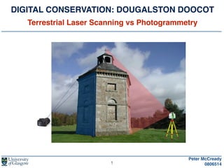
  • 1. DIGITAL CONSERVATION: DOUGALSTON DOOCOT! Terrestrial Laser Scanning vs Photogrammetry Peter McCready ! 08065141
  • 2. PRESENTATION OUTLINE Peter McCready ! 0806514 1. Project Overview 2. Deliverables 3. Study Area 4. Doocot - Interior and Exterior 5. Project Resources 6. Terrestrial Laser Scan 7. Photogrammetry 8. Comparison of Methodologies 2
  • 3. PROJECT OVERVIEW Peter McCready ! 0806514 Provisional Project Title: Digital building conservation: a comparative study of Terrestrial Laser Scanning and Photogrammetry. A case study of the Dougalston Estate Doocot in Milngavie, Glasgow. 3 • Interior and exterior Terrestrial Laser Scan (TLS) of the Doocot ! • Photogrammetry of a section of the Doocot ! • Generate 3D models from TLS and Photogrammetry data ! • Comparison of the two different methodologies ! • Submission of a 3D model to the Royal Commission on the Ancient and Historical Monuments of Scotland (RCAHMS) and provide model to local heritage and history groups Intentions:
  • 4. 1. Interior and exterior 3D model of the Doocot from TLS (That will be submitted to RCAHMS) ! 2. 3D model of a section of the Doocot from Photogrammetry ! 3. Comparison of the two different methods and a recommendation ! 4. Lessons learned and recommendations for a future project Peter McCready ! 0806514 DELIVERABLES 4
  • 6. DOOCOT Peter McCready ! 0806514 Exterior Visible Water Damage Hardcast Removal? Interior Brick Degradation Lantern Hole Covered Ladder and Axle Removed from Roof and Ground Housings Gaps in Roof Woodwork 6
  • 7. Peter McCready ! 0806514 PROJECT RESOURCES EQUIPMENT OFFICE HARDWARE PROCESSING SOFTWARE LEICA 1200 STATIC GNSS COMPUTER LEICA GEOOFFICE 8.1 LEICA SCANSTATION C10 LASER SCANNER EXTERNAL HARD DRIVE LEICA CYCLONE 8.1 LEICA HDS 6” TARGETS USB DRIVE AGISOFT PHOTOSCAN DSLR CAMERA CLOUD COMPARE (Open Source) RTK GNSS AUTODESK 3DS MAX (Trial Version) TRIPODS BLENDER (Open Source) 3m MEASURING TAPE (Instrument Heights) WOODEN STATION PEGS WAX PEN (To Mark Interior Station) 7
  • 8. 1. Control network setup! - Static GNSS - Check with RTK GNSS 2. HDS 6” target scanning (BS & FS)! ! - ! Adopting the Traverse Method! 3. Point cloud acquisition (Doocot Laser Scanning)! 4. Image acquisition (TLS Photography)! 5. Traverse to next station until complete! 6. Data cleaning & modelling Peter McCready ! 0806514 TLS PROCESS 8 Image Source: http://eca.state.gov/
  • 9. Peter McCready ! 0806514 TLS TRAVERSE • 6-10 Exterior Scans (Currently Undecided) • 1-3 Interior Scans (Currently Undecided) • Station C used as Reference Point for Interior Traverse 9 C H G I INTERIOR! TRAVERSEEXTERIOR TRAVERSE
  • 10. 1. Image capture! 2. Inspect image-set! 3. Photography processing - Structure From Motion (SFM)! - Image alignment, camera calibration & camera positioning - Feature point detection - Feature monitoring 4. 3D point cloud generation! 5. Building Mesh (Geometry)! 6. Texturing Peter McCready ! 0806514 PHOTOGRAMMETRY PROCESS 10 Image Source: http://michot.julien.free.fr/
  • 11. 1. Methodology (equipment requirement, expense etc.) 2. Point Cloud Accuracy 3. Data Capture Time 4. Data Processing Time Peter McCready ! 0806514 TLS vs PHOTOGRAMMETRY 11 • Will add to the comparison criteria after further reading Comparison Criteria:
  • 12. Please Contact:! ! Peter McCready - MSc Candidate ! 0806514m@student.gla.ac.uk FURTHER INFORMATION Peter McCready ! 0806514 References:! ! ! GREAT BRITAIN. Peter McGowan Associates (2006) Survey of Historic Gardens and Designed Landscapes in East Dunbartonshire, East Dunbartonshire: East Dunbartonshire Council ! UNITED STATES OF AMERICA. CALIFORNIA DEPARTMENT OF TRANSPORTATION. (2011) Caltrans Surveys Manual. State of California: Office of Land Surveys ! Verhoeven, G. (2011) Taking Computer Vision Aloft - Archaeological Three-Dimensional Reconstructions from Aerial Photographs with PhotoScan, Wiley Online Library [Online] Archaeological Prospection 18 (1) p.67-73. Available from: http://onlinelibrary.wiley.com/doi/10.1002/arp.399/full [Accessed: 7th May 2015] 12 THANK YOU! ANY QUESTIONS?