SlideShare une entreprise Scribd logo
1  sur  12
Télécharger pour lire hors ligne
th        st
                      FCRM>10, International Centre, Telford 28 June – 1 July 2010


CLIMATE CHANGE IMPACT ON CLIFF INSTABILITY AND EROSION
 Dr Roger Moore, Dr Jonathan Rogers, and Amy Woodget, Halcrow Group Ltd
                    Alison Baptiste, Environment Agency

ABSTRACT
The Floods and Water Management Act requires that FCRM properly reflects recently updated climate
change scenarios. The potential impacts of climate change and sea level rise on future cliff instability
and erosion present a significant challenge to future coastal management in the UK. The UK Climate
Projections 2009 (UKCP09) point to significant increases in winter rainfall frequency, intensity and
amount, drier summers and rising sea level which are likely to result in higher rates of cliff recession
due to toe erosion and more frequent coastal landslides.

These impacts will result in increased levels of risk to many coastal communities and assets at risk of
cliff instability and erosion which will require central and local government to develop and implement
policies that address the increasing risks, whilst also meeting the inevitable financial constraints.

This paper presents an overview of a high-level assessment of the likely climate change impacts on
cliff instability and erosion. The work was commissioned by the Environment Agency to support the
National Coastal Erosion Risk Mapping Project (NCERM). The results of the assessment have
informed where, and how, the NCERM erosion predictions should be modified to take into account the
climate change scenarios and predictions derived from UKCP09.

This important piece of research helps deliver the requirements of the Floods and Water Management
Act through application of climate change scenarios, so supporting the Environment Agency’s
overarching role. The research will ultimately ensure that NCERM, a high-profile, national scale
undertaking, makes best use of the most up-to-date climate change projections.

1.        INTRODUCTION
The National Coastal Erosion Risk Mapping Project (NCERM) is currently being conducted as part of
the Government’s Making Space for Water programme, on behalf of the Environment Agency. The
final output of NCERM is intended to provide an essential improvement to information on coastal
instability and erosion both for professionals and for the public; these are being created through an
innovative modelling procedure and web-based display, and have been reviewed and amended where
necessary by Local Authorities throughout England and Wales.

It is clear that predicted changes to UK climate and sea level over the next 100 years are likely to have
an adverse effect on coastal instability and erosion, through a number of mechanisms; namely
increased sea level leading to greater wave attack on coastal cliffs, and changes in the frequency,
intensity and duration of rainfall impacting on pre-existing coastal landslide complexes. The expected
implications of climate change and sea level rise present a significant challenge to future coastal
management. It is expected that there will be increased levels of risk to many coastal assets; the
challenge facing central and local government will be to develop and implement policies which
address the increasing risks, whilst also meeting the inevitable financial constraints.

This study looks to build contingency for future climate change into the coastal erosion projections
currently being developed by the NCERM project. The NCERM outputs provide risk bands of possible
coastal erosion for three epochs into the future (20, 50 and 100 years). The aim of this project is to
identify the relative vulnerability of cliffs to erosion and landsliding as a result of climate change, to
provide qualitative information on the probable impacts of climate change on cliff recession, and to
produce recommendations as to where, and how, this increased vulnerability should be reflected in
the NCERM output.

Reliable projection of cliff recession is fundamental to coastal planning and shoreline management.
Indication of the likely position of the cliff line at various epochs over the next 100 years is needed to
inform land use policies and to avoid locating new development in areas at risk of cliff recession; this
is highlighted in the Department of Communities and Local Government recently published (March
2010) supplement to PPS25 on Development and Coastal Change. Such projections might also be
used by coastal authorities to adopt a more proactive approach to evaluating the risks to existing
development, to provide warnings of the risks and to mitigate the potential impacts of cliff instability
and recession events through various adaptation measures.


                                                  079.1
th        st
                      FCRM>10, International Centre, Telford 28 June – 1 July 2010


Projections of cliff recession are also needed to decide on the preferred strategic coastal defence
option for specific management units identified in shoreline management plans. Where coast
protection works or improvements may be required, accurate projections of cliff recession rates are
needed to evaluate scheme options and to test their economic viability and cost-effectiveness. Such
decision-making depends on the reliability of cliff behaviour assessments and the prediction of future
cliff instability and erosion that account for the potential impacts of climate change and sea level rise.

Over the past two decades some considerable effort has been invested into identifying the methods
available for investigating and predicting cliff instability and erosion, most notably the recognition of
different types of cliff behaviour (e.g. regular retreat, sudden or meta-stable change, and episodic
landslide events) and the use of probabilistic approaches to address the uncertainty inherent in the
cliff recession process (Table 1). Whilst these landmark commissions provide a synthesis of available
assessment methods, sensitivity studies and datasets for cliffs, limited published data are available
that link historical cliff recession rates with climate and sea level change. This presents a key
uncertainty when evaluating the potential impacts of future climate change and sea level rise
predictions on cliff instability and erosion processes and associated cliff recession rates.

DATE       STUDY                 DESCRIPTION                                                      SOURCE
1994-      The Investigation     Prediction of recession rates and erosion control                MAFF
2001       and Management        techniques; the objectives of this research included the
           of Soft Rock Cliffs   development of analytical methods for predicting cliff
           (SRC)                 recession rates for the wide variety of differing situations
                                 around the coast
2000-      Preparing for the     This project developed a broad-scale approach to                 SCOPAC
2001       Impacts of Climate    evaluating the potential impacts of climate change and
           Change                relative sea level rise along the south coast of England.
                                 The approach involved identifying and characterising
                                 shoreline behaviour models which provide the basis for
                                 assessing changes in hazard and risk
2000-      Futurecoast           This was a regional-scale study of the coast of England          Defra
                                                               nd
2002                             and Wales to inform the 2 round Shoreline Management
                                 Plans. Futurecoast provides a robust geomorphological
                                 framework for conceptualising coastal evolution. It
                                 includes a database of coastal cliff behaviour units for
                                 England and Wales including various parameters of
                                 interest such as sensitivity to climate change and cliff
                                 recession potential.
2005-      Risk Assessment       The aim of this project was to develop, test and                 Defra
2006       of Coastal Erosion    disseminate a robust and consistent probabilistic method
           (RACE)                for assessing the hazard and risk of coastal erosion. The
                                 approach is supported by data and information from the
                                 Futurecoast cliff database, strategic coastal monitoring
                                 programmes and risk-based inspections. Five techniques
                                 are developed of increasing degrees of sophistication and
                                 data input, ranging from expert judgement to probabilistic
                                 cliff recession prediction.
2006-      National Coastal      This project aims to map lengths of coastline susceptible        EA
present    Erosion Risk          to cliff instability and erosion from natural processes whilst
           Mapping Project       taking account of the possible impacts of climate change
                                 and coastal defence policy and management. The project
                                 has developed innovative web-based software utilising the
                                 methods developed by RACE.
                      Table 1 – Previous work on cliffs in England and Wales

2.        CLIFF INSTABILITY AND EROSION - DEFINITIONS
Coastal erosion is a process driven by wave and tidal energy at the coast which is dissipated by
frictional drag associated with the scour, mobilisation and transport of sediments by tides and waves.
Where coastal hinterlands and backshores are elevated relative to sea level, the action of waves and
tides will erode and undercut the base of cliffs which will develop a characteristic morphology and
profile reflecting their geological composition, structural form and evolution.


                                                  079.2
th        st
                       FCRM>10, International Centre, Telford 28 June – 1 July 2010


Cliff instability involves slope failure and mass movement of a coastal slope or cliff and may result in
the heave and deposition of debris on the beach and foreshore, noting that some landslides are large-
scale and extend a considerable distance inland and offshore, and deep below beach level. Therefore,
cliff instability and erosion in this context is a four stage process involving detachment of particles or
blocks of material, the transport of this material through the cliff system, its deposition on the foreshore
and its removal by wave and tidal action.

Cliff recession is the landward retreat of the cliff profile (from cliff toe to cliff top) in response to cliff
instability and erosion processes. It is not a simple or uniform process in space or time and depends
on a variety of factors that control the rates of detachment and transport.

3.        CLIFF BEHAVIOUR UNITS
The concept of a cliff behaviour unit (CBU) provides an important framework for the investigation and
management of cliffs (Lee 1997, Moore et al. 1998). Cliff behaviour units include the foreshore and the
cliff top as these component landforms, and the processes that act upon them, can have a significant
influence on cliff instability and recession behaviour. They are cascading systems or open sediment
transport systems characterised by inputs, throughputs and outputs. Defra’s ‘Investigation and
Management of Soft Rock Cliffs’ (Lee and Clark 2002) provides further background to the concept and
classifies diagnostic CBUs according to their relative complexity, as follows:


  Figure 1 – CBU types in England and Wales: top left, Simple Cliff, Birling Gap East Sussex; top
  right, Composite Cliff, Purbeck Dorset; lower left, Simple Landslide, Scarborough North Yorkshire;
                              lower right, Complex Cliff, Black Ven Dorset

Simple cliff face systems: a single sequence of inputs from falls or slides leading almost directly to
foreshore deposition. There is usually a steep cliff face, narrow degradation zone and rapid response
to toe erosion. This type of cliff will fail as a result of toe erosion and undercutting, so relative sea level
rise (RSLR) is the main forcing parameter. Examples include the Chalk cliffs of Sussex (Figure 1) and
the hard rock cliffs of Cornwall.

Simple landslide systems: a single sequence of inputs and outputs with variable amounts of storage. A
marked degradation and storage zone is usually apparent affording limited buffering against toe
erosion. This system will be affected by erosion of the landslide toe and excess groundwater in the
slide zone; therefore both sea level and rainfall are key forcing parameters of equal importance.
Examples include the cliffs formed in glacial tills in North Yorkshire (Figure 1) and the London Clay in
Essex and Kent.


                                                    079.3
th        st
                      FCRM>10, International Centre, Telford 28 June – 1 July 2010


Composite cliff systems: partly coupled sequences of contrasting simple sub-systems, typically
comprising interbedded hard and soft rocks. Around the coast of England and Wales composite cliffs
are formed where hard cap rocks are underlain by clayey strata giving a distinct steep upper cliff face
and a tendency for high magnitude, low frequency failures. Composite cliffs are sensitive to changes
in toe erosion and groundwater where soft rock occurs above hard rock. Examples include the till-
capped cliffs of North Yorkshire and the hard rock capped cliffs of Purbeck and Portland (Figure 1).


               Figure 2 – Futurecoast CBU parameters and statistics (values in km)

Complex cliff systems: strongly coupled sequences of scarp and bench sub-systems, each with their
own inputs, storage and outputs of sediment. The output from one system forms a cascading input to
the next resulting in close adjustment of process and form with complex feedbacks. The sub-system
storage results in significant buffering against the immediate effects of toe erosion, although elevated
groundwater levels can trigger major events that can transform the behaviour of the whole system
(e.g. major mudsliding episodes), hence groundwater is the main forcing parameter in the short-term.


                                                 079.4
th       st
                      FCRM>10, International Centre, Telford 28 June – 1 July 2010


The impact of toe erosion occurs over much longer timescales i.e. 100s or 1000s of years. Examples
include the Ventnor Undercliff, Isle of Wight, and Black Ven, Dorset (Figure 1).

Relict cliff systems: sequences of pre-existing landslides susceptible to reactivation and exhumation
by coastal erosion operating over long timescales. They include abandoned cliffs and slopes formed
by ancient landslides that have the potential to become reactivated by toe erosion and or excess
groundwater levels. Examples include the Undercliffs at St Catherine’s Point, Isle of Wight, and
Bindon, South Devon.

The Futurecoast Cliffs Database (Halcrow 2002) provides a systematic assessment of the coastal
cliffs of England and Wales in accordance with this CBU classification. Out of a total of 6,251km of
coastline in England and Wales (NCERM database), 3,327km (53%) are cliffs subject to cliff instability
and erosion. The database includes information on cliff materials, failure mechanisms, presence of cliff
engineering and coastal defences, activity status, recession potential magnitude and frequency,
sediment supply potential, sensitivity to climate change and uncertainty assessment (Figure 2). These
data provide a valuable resource for cliff behaviour assessments and recession prediction studies.

4.       CLIFF RECESSION PREDICTION
Cliff behaviour assessment involves the measurement of historical and contemporary rates of cliff
recession, consideration of the geological, geomorphological, geotechnical and hydrogeological
controls, and the influence of coastal processes. At some sites, specific monitoring of cliff behaviour is
carried out and there is now an increased awareness and commitment to carrying out strategic
monitoring of the coastline and cliffs for scientific and management purposes (Bradbury 2001).

In the past, most cliff recession studies were necessarily qualitative due to the lack of accurate spatial
and temporal data, with heavy reliance given to expert judgement and the use of historical records
where the errors in data and interpretation were neither quantified nor made explicit. Technology now
exists to make better use of historical mapping and aerial photographs where the errors of data and
interpretation of features can be quantified to a high degree of accuracy. In the context of a wider cliff
behaviour assessment, use of a quantitative approach can significantly improve confidence with future
projections of cliff recession (Moore et al. 2003).

             HISTORICAL AND CURRENT                       GEOLOGY AND
             CHANGES                                      GEOMORPHOLOGY
             • Futurecoast                                • Futurecoast
             • SMP II                                     • Academic papers
             • EA records                                 • Geological Survey memoirs
             • Published papers and diaries               • Consultants’ reports
             • Maps, DTMs & photos                        • Ground investigation data


                                              BEHAVIOUR
                                                MODEL


                                         PREDICTIVE MODEL:
                                          100 YR RECESSION
                                               PROFILES

                    Figure 3 – Cliff Behaviour and Prediction Model Framework

To gain an understanding of coastal cliff behaviour, it is necessary to have some factual information
on historical and current rates of change in the landform and of the geology and geomorphology. This
information can then be used to develop a conceptual cliff behaviour model, encapsulating interacting
geomorphic components, which can then be used to derive a predictive model (Figure 3).

Future cliff behaviour is determined by the impact of changing system controls on past behaviour.
Changing system controls include external factors, such as sea level rise and climate change, and


                                                  079.5
th       st
                      FCRM>10, International Centre, Telford 28 June – 1 July 2010


internal factors such as variations in materials or hinterland geomorphology. The impact of changing
system controls on the behaviour of coastal landforms can be determined by a range of approaches,
including the following:

    •   Extrapolation of historical data
    •   Expert judgement, e.g. from cliff behaviour models
    •   Probabilistic simulation modelling
    •   Process-response simulation modelling
    •   Empirical modelling

These approaches involve an increasing degree of analysis, but do not necessarily provide an
increasing level of accuracy. Furthermore, all approaches rely on the provision of historical recession
rates, either as the basis for prediction or for model calibration. The ultimate precision of outputs is
constrained by uncertainty over future climate and weather conditions, the physical properties and
behaviour of the landform, the precise timing and magnitude of individual recession events and the
future cliff recession rate.

Walkden and Hall (2005) have developed a model, known as Soft Cliff and Platform Erosion (SCAPE)
to represent the main processes that influence an eroding shoreline under RSLR. Lee (2005) provides
a summary of the issues and a comparison of various deterministic and probabilistic approaches for
cliff recession prediction, and presents a simple judgement-based model for evaluating cliff recession
risk. These and other approaches are generally limited in their application by the absence of quality
empirical datasets to quantify the relationships between cliff recession and the various controlling
factors. An example is the relationship between historical cliff recession rates and sea level rise; Lee
(2005) presents some data for the Suffolk coast but little is known about this relationship elsewhere
along the coast of England and Wales. Similarly, only a few studies (e.g. Moore et al., 2007) have
assembled datasets to quantify the effects of winter rainfall on coastal instability and landslides which
are a major contributor to coastal recession at a number of key sites.

Therefore, it is not possible to reliably model the effects of climate change on coastal cliffs using a
quantitative modelling approach, particularly where this is based on extrapolation of past events alone.
Such approaches do not take account of the potential uncertainty and variability of the cliff recession
process. Consequently a judgment based assessment which brings together data concerning
historical cliff behaviour with latest projections of UK climate change provides a pragmatic approach
where the uncertainties can be explicitly expressed and accounted for, utilising numerical models as
appropriate.

A key objective of cliff behaviour assessment is not only to understand the materials, forms and
processes of cliff systems but also their sensitivity to change and evolution through time. The
timescales over which these factors are considered has a significant bearing on how the cliff instability
and erosion process appears to have operated in historical times. The significance of past events and
cliff recession rates need to be evaluated in this context. Lee and Clark (2002) identify three important
timescales for cliff management purposes:

1. short-term, where recession can be a highly variable process
2. medium-term, where fluctuations are smoothed out and there is an apparent balance between
   form and process
3. long-term, where the nature and rates of cliff behaviour may change in response to internal and
   external influences, such as variations in lithology and sea level

In the context of this study, it is important to note that certain CBUs will be characterised by frequent
erosion (typically represented as an annual rate), whereas others will be characterised by less
frequent (episodic) landslides, or indeed through a combination of both. These mechanisms and
processes control the timing (frequency) and amount (magnitude) of cliff recession.

The RACE and NCERM cliff recession prediction models provide a hierarchy of approaches in line
with the above review (Table 2). These have increasing levels of complexity, providing incremental
improvements in the quality of output, but also necessitating higher levels of data input, knowledge
and time. Proportionate effort is therefore a consideration in deciding upon the technique to adopt. The
description of each technique includes guidance on how it can be carried out, advice on suitability of
use and limitations of the method.


                                                 079.6
th        st
                       FCRM>10, International Centre, Telford 28 June – 1 July 2010


Technique              General Description                   Main Points
1 Technical            Experience based assessment for       Quick and easy method. Crude
   Judgement           use with minimal data                 examination.
2 Futurecoast          Uses data from the Futurecoast        Consistency of available data lends itself
   Assessment          Cliffs Database                       to national application.
3 Site Specific        Combines data from Futurecoast        More accurate than Technique 2, although
   Assessment          with real data (e.g. more up to       some aspects remain imprecise. Some
                       date aerial photographs)              Local Authorities may already have such
                                                             studies available.
4   Single             Uses purely real data and             Very robust method that will deliver
    Recession Rate     methods recommended by the            reliable results. Data requirements exceed
    Method             SRC manual to calculate single        Techniques 1 to 3. Methods require
                       recession rates.                      extensive data and expert input.
5   Probabilistic      Uses purely real data and             Can provide most accurate output when
    Method             methods recommended by the            informed by good quality input data and
                       SRC manual to calculate single        expert input.
                       recession rates.
                    Table 2 – RACE/NCERM cliff recession prediction approaches

5.      IMPACTS OF CLIMATE CHANGE (UKCP09)
SCOPAC (Halcrow 2001) commissioned a landmark project to review the potential impacts of climate
change along the south coast between Lyme Regis and Shoreham-by-Sea where it is anticipated that
coastal flooding and erosion will present a significant challenge to future coastal management. The
review highlighted that climate change is likely to result in changes to three key forcing agents
including sea level rise, changes in wave direction and increased winter rainfall, with a tendency for
more extreme events (Hosking and Moore 2002). The present study has reviewed these forcing
parameters against the latest UKCP09 climate change projections (Table 3).

To capture the full range of possibilities, climate change projections of RSLR and winter effective
rainfall (WER) under high and low emissions scenarios (HES and LES) are considered. Neither of
these parameters are directly output by UKCP09 and require interrogation and processing of projected
datasets. Analysis of these projections revealed that projected changes in wave direction impact on
cliffs in England and Wales was a relatively insignificant parameter compared to RSLR and WER.
Furthermore, regional variations in projections were also found to be relatively insignificant and that
the rate of change was broadly linear over the next 100 years across the full range of scenarios.

The impact of RSLR and increased WER are likely to result in higher coastal erosion rates and more
frequent coastal landslides. The rate of change of these impacts cannot be reliably quantified;
however an estimate may be made by expert judgment. Whilst such judgements are based on limited
empirical data, they represent the best available estimates and are informed by current data and
knowledge of specific sites and the potential impacts of climate change (e.g. Lee 2005; Moore et al.,
2007) based on this approach. Table 3 presents a matrix of estimated impacts of UKCP09 HES and
LES projections on cliff erosion rates and cliff instability (landslide) frequency for cliffs of various
sensitivity to climate change and sea level rise (from Futurecoast) over the next 100 years.

Source                           Parameters                UKCP09 LES               UKCP09 HES
UKCP09                  Predicted rise in RSLR                26-37cm                  40-51cm
                        Predicted rise in WER                  5-24%                    9-40%
Impact on ‘high’        Increase in cliff erosion rate        50-75%                  50-100%
sensitivity cliffs      Increase in cliff instability and    100-200%                 100-400%
                        landslide frequency
Impact on ‘medium’      Increase in cliff erosion rate        10-25%                   10-50%
sensitivity cliffs      Increase in cliff instability and     20-50%                  20-100%
                        landslide frequency
Impact on ‘low’         Increase in cliff erosion rate         0-5%                     0-10%
sensitivity cliffs      Increase in cliff instability and      0-10%                    0-20%
                        landslide frequency
Note: values in bold indicate the extremes of the ranges as used for validation of NCERM
         Table 3 – Estimated impact of UKCP09 scenarios on cliff instability and erosion


                                                  079.7
th        st
                      FCRM>10, International Centre, Telford 28 June – 1 July 2010


6.       NCERM VALIDATION AND CLIMATE CHANGE IMPACT ASSESSMENT
This section presents the findings of the review and validation of historical cliff behaviour and cliff
recession projection of 172 CBUs which form 22 priority sites (Figure 4). These sites form a small sub-
set of a total of 116 sites identified by Futurecoast as ‘high’ sensitivity to climate change. They were
selected due to the availability of site-specific data on cliff instability and erosion from Halcrow’s
project archives which provide independent validation of the Futurecoast and NCERM datasets.


                                 Figure 4 – NCERM validation sites


                                                 079.8
th         st
                         FCRM>10, International Centre, Telford 28 June – 1 July 2010


The main objectives of the site-specific validation and review of cliff recession projections accounting
for climate change were as follows:
1. Review of the defined NCERM CBU extents, and the relative significance of annual toe erosion
   and the magnitude and frequency of cliff instability and landslide events that govern future cliff
   recession.
2. Development of rule sets for validation and cliff recession prediction for Complex and Non-
   Complex Cliffs accounting for the impacts of climate change (principally RSLR and WER).
3. Critical review of long-term historical cliff recession rates and landslide event magnitude and
   frequency, and determination of validated empirical values for use by NCERM.
4. Independent projection of future cliff recession accounting for UKCP09 HES and LES climate
   change impacts and comparison with non-validated NCERM projections.
Non-Complex Cliffs
For simple cliffs, simple landslides and composite cliffs considered in this assessment, a simplified
assumption is made that future cliff recession will be driven by toe erosion. Therefore, these CBU
types are treated together as ‘non-complex cliffs’. By definition, these cliff types are characterised by
various rates of cliff toe erosion which is generally in balance and equal to the rate of cliff top
recession (Lee & Clark 2002). The feedback mechanism from the point of toe erosion to cliff top
recession is in many cases subject to delay or time-lag. However, the frequency of erosion and
landslide events is sufficiently high or short-term (i.e. <1:100 years) to be accounted for by
assessments of long term historical erosion dating back to the 19th Century. Thus, for non-complex
cliffs it is appropriate to use the historical annual cliff recession rate as a basis for future prediction.

The first step in calculating projected recession distances for non-complex cliffs is to validate the
baseline historical recession rate. This baseline is taken to be the long-term historical value derived
from accurate measurement of historical maps and aerial photographs of the site (Table 4). For
example, the validated long-term historical recession rate for Site 19: Happisburgh is 3.25m/yr. This
baseline rate is projected to increase over the next 100 years due to the impact of climate change on
high sensitivity cliffs subject to erosion (Table 3). Thus, the recession rate under the UKCP09 HES is
incremented by 1% per year, so that by year 100 the rate has increased by a total of 100% i.e.
6.5m/yr; note that this value is the upper bound increase projected under the full range of UKCP09
scenarios. The cumulative recession distance year on year is then calculated up to year 100. This
allows projected recession distances for 20, 50 and 100 years under UKCP09 low and high emissions
scenarios to be determined (Table 4).
  Site      Site Location                              Validated          Projected cliff recession rate under
  No.                                                historical cliff             UKCP09 HES (m/yr)
                                                     recession rate
                                                                             2029           2059            2109
                                                         (m/yr)
    1       Barn Scar & Carl Crag, Cumbria                0.25               0.3             0.38           0.5
            Whitriggs Scar, Cumbria                       0.18               0.21            0.27           0.36
    2       Barton to Naish Farm,
                                                           1.03              1.23            1.55           2.06
            Hampshire
            Mundesley to Bacton Green,
    3                                                   0.9 - 1.51        1.08 - 1.81    1.35 - 2.27    1.80 - 3.02
            Norfolk
   4        Swanage Bay, Dorset                           0.09                0.11           0.14           0.18
   5        Church Cliff, Dorset                           0.2                0.24            0.3            0.4
   6        Higher Sea Lane, Dorset                        1.5                 1.8           2.25            3.0
  11        St.Bees/Pow Beck, Cumbria                     0.59                0.71           0.89           1.18
  12        Nethertown, Cumbria                           0.07                0.08           0.11           0.14
  14        Swanage, Dorset                                0.3                0.36           0.45           0.6
  16        South coast, Isle of Wight                 0.11 - 0.41        0.13 - 0.49    0.17 - 0.62    0.22 - 0.82
  17        Southeast coast, Isle of Wight                0.26                0.31           0.39           0.52
  18        Fairlight, East Sussex                        0.64                0.77           0.96           1.28
  19        Happisburgh, Norfolk                          3.25                3.90           4.88           6.50
  20        Cayton Bay, North Yorkshire                    1.0                1.20           1.50            2.0
21 & 22     Filey South                                 0.2 - 1.0          0.24 - 1.2     0.30 - 1.5     0.40 - 2.0
Note: for multiple CBUs where variations in geology are significant the range of cliff recession rates is quoted
         Table 4 – Validated cliff recession rates and HES projections for non-complex cliffs


                                                       079.9
th            st
                          FCRM>10, International Centre, Telford 28 June – 1 July 2010


The percentage increase in annual recession due to climate change is applied linearly to 2080 yet
NCERM projections are provided to 2109. For the purposes of this assessment, the percentage
increases in recession due to climate change are applied for the next 100 years, to 2109, in line with
NCERM; however, it is noted that this involves projection of the UKCP09 climate change projections
beyond their intended time limit and as a consequence may under-estimate the full impact of climate
change on cliff recession beyond 2080, which is uncertain.

Site     Site Location               Validated       Validated         Projected landslide frequency under
No.                                  landslide       landslide                 UKCP09 HES (years)
                                     magnitude      frequency
                                                                         2029          2059           2109
                                        (m)           (years)
  2      Barton, Hampshire               2-5           5 - 13            5 - 13      3.3 - 8.7      2.5 – 6.5
         East Cliff, Spittles &
5&6                                     30 - 50       25 - 30           25 - 30       8.3 - 10         5-6
         Black Ven, Dorset
         Warden Point, Isle of
  7                                       30          35 - 50           35 - 50       12 - 17         7 - 10
         Sheppey, Kent
         Covehurst Bay,
  8                                       60             50               50             17             10
         Fairlight, East Sussex
         Ventnor Undercliff,
  9                                       50            500*              500           500            500
         Isle of Wight*
         Cayton Cliff, North
 10                                       10             40               40             13             8
         Yorkshire
         St Bees/Pow Beck,
 11                                       50            500               500           167            100
         Cumbria

 13      Lyme Bay, Dorset               30 - 92       30 - 500
                                                                       30 - 500      10 - 167        6 - 100
         Gurnard Ledge, Isle
 15                                       15         50 - 500*         50 - 500      16.7 - 500      10 - 500
         of Wight
         South coast, Isle of
 16                                     20 - 50      50 - 500*         50 - 500      16.7 - 500      10 - 500
         Wight
         Southeast coast, Isle
 17                                     10 - 50      10 - 500*         10 - 500      3.3 - 500       2 - 500
         of Wight
 18      Fairlight, East Sussex           10             50               50           16.7             10
         Filey South, North
 22                                       10             10               10             3.3            2
         Yorkshire
*denotes CBUs where landsliding frequency is historically very low and where the impact of climate change is not
expected to be significant over the next 100 years
       Table 5 – Validated magnitude and frequency and HES projections for complex cliffs

Complex Cliffs
For complex cliffs (Figure 4), the frequency and magnitude of episodic landslide events, caused by
long-term coastal erosion and site-specific ground conditions, are dominant controls of cliff top
recession. Many of the UK’s complex and relict coastal landslide systems are many thousands of
years old and have remained dormant over the historical period. However, they are subject to ground
movement, reactivation and occasional landslide events which pose a risk to development and
infrastructure located upon them. An important feature of these systems is the presence of a rear
scarp some distance inland of the sea-cliff or landslide toe; erosion of the landslide toe and adverse
ground conditions potentially influences recession of the rear scarp, therefore, an important
consideration of such assessments is to accurately map the full extent of complex cliffs. This is often a
shortcoming of SMPs and other regional cliff studies.


                                                    079.10
th       st
                      FCRM>10, International Centre, Telford 28 June – 1 July 2010


For complex systems where annual erosion rate is used alone for future projection, it is likely that this
may lead to significant under-prediction of future cliff recession where change is driven by episodic
large-scale landslide events. Conversely, applying both annual erosion and episodic landslide events
recession may lead to over-prediction. Thus for complex cliffs, landslide magnitude and frequency only
are used as a basis for prediction of future cliff recession.

The first step in calculating projected future recession distances for complex cliffs is to validate the
historical landslide frequency (Table 5). The validated landslide frequency is then converted to an
annual probability. The annual probability is then modelled to increase with climate change (Table 3),
with the total increase in landslide frequency achieved by year 100. The increase in landslide
frequency is applied linearly to 2109; however, this involves projection of UKCP09 data beyond their
intended timeframe and as a consequence may under-estimate the full impact of climate change on
landslide frequency beyond 2080, which is uncertain.

Cumulative probabilities are then calculated; when the cumulative probability is equal to 1 a landslide
event and associated cliff recession will have occurred. It is not possible to precisely predict the next
landslide occurrence so it is assumed the first landslide event in the series occurs in year 1. By
multiplying the number of landslide occurrences within each time frame (20, 50, 100 years) with
landslide magnitude, the amount of cliff recession is determined for LES and HES climate projections.
This is a generic approach applied to all complex cliffs where recession of the headscarp is expected
as a result of episodic coastal instability and erosion in the next 100 years. The exceptions to the rule
are those CBUs where headscarp recession is not expected in the next 100 years and for these cases
the projected recession distance is set to 0m. Despite the lack of headscarp recession of some
complex cliffs they remain at risk of coastal instability and erosion at any time involving toe erosion,
ongoing ground movement and periodic landslides within the mapped extent of the cliff system.

7.       Results and Discussion
The results of the cliff behaviour assessment and validation of 22 priority sites has revealed the
following. There is close agreement between NCERM and independently validated cliff recession
projections for high sensitivity non-complex cliffs where there is a relatively direct link between toe
erosion and cliff top recession rates. The NCERM projections (defined by best and worst case) have
sufficient range or contingency to account for UKCP09 climate change scenarios up to 50 years from
now and in many cases up to 100 years from now. This is a significant outcome of the study as it
confirms that NCERM, a high-profile, national scale undertaking, accounts for the most up-to-date
climate change projections for about 90% of the cliffs database for England and Wales.

Complex cliffs comprise less than 10% of the cliffs database and nearly half of these are rated as
high-sensitivity to climate change (Figure 2). They are characterised by an indirect and delayed
response between toe erosion and cliff top recession controlled by site-specific ground conditions and
excess groundwater levels triggering episodic large landslide events; individual CBUs have unique
historical cliff behaviour and sensitivity to future climate change and sea level rise.

The results of independent validation and recession projection for high-sensitivity complex cliffs have
revealed significant differences with NCERM projections. The differences are randomly distributed and
highlight issues regarding mapping of complex cliff extents, and validation of appropriate landslide
magnitude and frequency values. The majority of NCERM projections show significant under-
prediction of potential cliff recession for complex cliffs and generally do not have sufficient range or
contingency to account for UKCP09 LES and HES under any timeframe; further it is not considered
realistic to modify NCERM to account for climate change without introducing orders of magnitude of
uncertainty in future cliff recession projections. Therefore, complex cliffs should be considered a
special case and assessed on their individual merits as toe erosion is not necessarily the main driver
of cliff top recession in the short- and medium-term, a recommendation which is being taken forward
by NCERM.

ACKNOWLEDGEMENTS
The authors are grateful to the Environment Agency for permission to publish this work. The
contributions of colleagues at Halcrow Group Ltd are also acknowledged.

REFERENCES
Bradbury A (2001). Strategic monitoring of the coastal zone - towards a regional approach. Proc. 36th
       DEFRA Conf. of River and Coastal Engineers, 5.2.1-13.


                                                 079.11
th        st
                     FCRM>10, International Centre, Telford 28 June – 1 July 2010


Halcrow Group Ltd. (2001). Preparing for the Impacts of Climate Change: a strategy for long term
       planning and management of the shoreline in the context of climate change. Summary report
       and CD of full report prepared on behalf of SCOPAC.
Halcrow Group Ltd. (2002). Futurecoast. DEFRA.
Halcrow Group Ltd. (2006). Risk Assessment of Coastal Erosion. Technical report (2 vols) to DEFRA.
Hosking ASD and Moore R (2002). Preparing for the impacts of climate change on the central south
       coast of England. In RG McInnes and J Jakeways (eds) Instability, Planning and
       Management: seeking sustainable solutions to ground movement problems, Thomas Telford,
       2002. P601-08.
Lee E M and Clark A R 2002. Investigation and management of soft rock cliffs. Thomas Telford.
Lee EM (1997). The investigation and management of soft rock cliffs. Proc. MAFF Conf. of River and
       Coastal Engineers, B.1.1-12.
Lee EM (2005). Coastal cliff recession risk: a simple judgement-based model. Quarterly Journal of
       Engineering Geology and Hydrogeology 38, 89-104.
Moore R, Carey J, McInnes RG & Houghton J (2007). Climate change, so what? Implications for
       ground movement and landslide event frequency in the Ventnor Undercliff, Isle of Wight. Proc.
       Int. Conf. on Landslides and Climate Change, Ventnor, Isle of Wight. P335-344.
Moore R, Clark AR and Lee EM (1998). Coastal Cliff Behaviour and Management: Blackgang, Isle of
       Wight. In: Maund JG and Eddlestone M (eds.) Geohazards in Engineering Geology.
       Geological Society, London, Engineering Geology Special Publications, 15; 49-59.
Moore R, Fish P, Glennerster M & Bradbury A (2003). Cliff behaviour assessment: a quantitative
                                                                th
       approach using digital photogrammetry and GIS. Proc. 38 DEFRA Conf. of River and Coastal
       Engineers, 08.3.1-08.3.13, 2003.
Walkden MJA and Hall JW (2005). A predictive Mesoscale model of the erosion and profile
       development of soft rock shores. Coastal Engineering 2005, 52(6), 535-563.


                                               079.12

Contenu connexe

Tendances

Sea Level Rise Inundation Mapping for the ART Project
Sea Level Rise Inundation Mapping for the ART ProjectSea Level Rise Inundation Mapping for the ART Project
Sea Level Rise Inundation Mapping for the ART ProjectJustin Vandever
 
Beach surf zone morphodynamics muy bueno
Beach surf zone morphodynamics muy buenoBeach surf zone morphodynamics muy bueno
Beach surf zone morphodynamics muy buenoEdgar Bernabe
 
Sweetwater Reservoir Habitat Recovery Plan Risk Assessment
Sweetwater Reservoir Habitat Recovery Plan Risk AssessmentSweetwater Reservoir Habitat Recovery Plan Risk Assessment
Sweetwater Reservoir Habitat Recovery Plan Risk Assessmentmsweesy
 
SeaLevelRiseSB_Brief
SeaLevelRiseSB_BriefSeaLevelRiseSB_Brief
SeaLevelRiseSB_BriefAlyssa Hall
 
NMOC News april 16
NMOC News april 16NMOC News april 16
NMOC News april 16dyannafrye
 
Factoring People into Ecosystems
Factoring People into Ecosystems Factoring People into Ecosystems
Factoring People into Ecosystems Ecotrust
 
Research on Manasbal Lake
Research on Manasbal LakeResearch on Manasbal Lake
Research on Manasbal LakeShakil Romshoo
 
8. nap sdg i frame weds main
8. nap sdg i frame weds main8. nap sdg i frame weds main
8. nap sdg i frame weds mainNAP Events
 
12. analyzing climate change risks
12. analyzing climate change risks12. analyzing climate change risks
12. analyzing climate change risksNAP Events
 
C0.6: GEO and WOA: A Call for Collaboration - David Halpern
C0.6: GEO and WOA: A Call for Collaboration - David HalpernC0.6: GEO and WOA: A Call for Collaboration - David Halpern
C0.6: GEO and WOA: A Call for Collaboration - David HalpernBlue Planet Symposium
 
10. identifying systems for assessment a demo using food security
10. identifying systems for assessment a demo using food security10. identifying systems for assessment a demo using food security
10. identifying systems for assessment a demo using food securityNAP Events
 
US Fleet Forces Environmental Readiness
US Fleet Forces Environmental ReadinessUS Fleet Forces Environmental Readiness
US Fleet Forces Environmental ReadinessBryanHall58
 
NAVFAC Pacific Natural Resources Program
NAVFAC Pacific Natural Resources ProgramNAVFAC Pacific Natural Resources Program
NAVFAC Pacific Natural Resources ProgramBryanHall58
 
NicheEH_CV_MatthewRussell_2015
NicheEH_CV_MatthewRussell_2015NicheEH_CV_MatthewRussell_2015
NicheEH_CV_MatthewRussell_2015Matthew Russell
 

Tendances (20)

Sea Level Rise Inundation Mapping for the ART Project
Sea Level Rise Inundation Mapping for the ART ProjectSea Level Rise Inundation Mapping for the ART Project
Sea Level Rise Inundation Mapping for the ART Project
 
Beach surf zone morphodynamics muy bueno
Beach surf zone morphodynamics muy buenoBeach surf zone morphodynamics muy bueno
Beach surf zone morphodynamics muy bueno
 
Clarisse_Betancourt_Poster_Presentation
Clarisse_Betancourt_Poster_PresentationClarisse_Betancourt_Poster_Presentation
Clarisse_Betancourt_Poster_Presentation
 
Sweetwater Reservoir Habitat Recovery Plan Risk Assessment
Sweetwater Reservoir Habitat Recovery Plan Risk AssessmentSweetwater Reservoir Habitat Recovery Plan Risk Assessment
Sweetwater Reservoir Habitat Recovery Plan Risk Assessment
 
Cooperations on climate change in the Carpathian region
Cooperations on climate change in the Carpathian regionCooperations on climate change in the Carpathian region
Cooperations on climate change in the Carpathian region
 
SeaLevelRiseSB_Brief
SeaLevelRiseSB_BriefSeaLevelRiseSB_Brief
SeaLevelRiseSB_Brief
 
NMOC News april 16
NMOC News april 16NMOC News april 16
NMOC News april 16
 
K thompson may 2014
K thompson may 2014K thompson may 2014
K thompson may 2014
 
Factoring People into Ecosystems
Factoring People into Ecosystems Factoring People into Ecosystems
Factoring People into Ecosystems
 
Research on Manasbal Lake
Research on Manasbal LakeResearch on Manasbal Lake
Research on Manasbal Lake
 
LAMP Nutrient Status Report 2010
LAMP Nutrient Status Report 2010LAMP Nutrient Status Report 2010
LAMP Nutrient Status Report 2010
 
Alaska
AlaskaAlaska
Alaska
 
8. nap sdg i frame weds main
8. nap sdg i frame weds main8. nap sdg i frame weds main
8. nap sdg i frame weds main
 
12. analyzing climate change risks
12. analyzing climate change risks12. analyzing climate change risks
12. analyzing climate change risks
 
C0.6: GEO and WOA: A Call for Collaboration - David Halpern
C0.6: GEO and WOA: A Call for Collaboration - David HalpernC0.6: GEO and WOA: A Call for Collaboration - David Halpern
C0.6: GEO and WOA: A Call for Collaboration - David Halpern
 
10. identifying systems for assessment a demo using food security
10. identifying systems for assessment a demo using food security10. identifying systems for assessment a demo using food security
10. identifying systems for assessment a demo using food security
 
2. c2 c
2. c2 c2. c2 c
2. c2 c
 
US Fleet Forces Environmental Readiness
US Fleet Forces Environmental ReadinessUS Fleet Forces Environmental Readiness
US Fleet Forces Environmental Readiness
 
NAVFAC Pacific Natural Resources Program
NAVFAC Pacific Natural Resources ProgramNAVFAC Pacific Natural Resources Program
NAVFAC Pacific Natural Resources Program
 
NicheEH_CV_MatthewRussell_2015
NicheEH_CV_MatthewRussell_2015NicheEH_CV_MatthewRussell_2015
NicheEH_CV_MatthewRussell_2015
 

En vedette

L7 impacts of cliff collapse
L7 impacts of cliff collapseL7 impacts of cliff collapse
L7 impacts of cliff collapseandypinks
 
L1 ap lyme regis cliff collapse
L1 ap lyme regis cliff collapseL1 ap lyme regis cliff collapse
L1 ap lyme regis cliff collapseandypinks
 
5 hurst + sturt v2
5 hurst + sturt v25 hurst + sturt v2
5 hurst + sturt v2Mark Ollis
 
6. cliff recession
6. cliff recession6. cliff recession
6. cliff recessionhfonfe
 
Pop-Up Coastal Protection
Pop-Up Coastal ProtectionPop-Up Coastal Protection
Pop-Up Coastal ProtectionTonyCassidy
 
Coastal Case Studies
Coastal Case StudiesCoastal Case Studies
Coastal Case Studiesdonotreply16
 
GCSE Geography Coasts Revision
GCSE Geography Coasts RevisionGCSE Geography Coasts Revision
GCSE Geography Coasts RevisionBenny Lowrie
 
Coastal erosion processes
Coastal erosion processesCoastal erosion processes
Coastal erosion processesMsGeo
 
2. barton on sea v3
2. barton on sea v32. barton on sea v3
2. barton on sea v3Mark Ollis
 

En vedette (11)

Cliff Recession
Cliff RecessionCliff Recession
Cliff Recession
 
L7 impacts of cliff collapse
L7 impacts of cliff collapseL7 impacts of cliff collapse
L7 impacts of cliff collapse
 
L1 ap lyme regis cliff collapse
L1 ap lyme regis cliff collapseL1 ap lyme regis cliff collapse
L1 ap lyme regis cliff collapse
 
Cliff collapse case study
Cliff collapse case studyCliff collapse case study
Cliff collapse case study
 
5 hurst + sturt v2
5 hurst + sturt v25 hurst + sturt v2
5 hurst + sturt v2
 
6. cliff recession
6. cliff recession6. cliff recession
6. cliff recession
 
Pop-Up Coastal Protection
Pop-Up Coastal ProtectionPop-Up Coastal Protection
Pop-Up Coastal Protection
 
Coastal Case Studies
Coastal Case StudiesCoastal Case Studies
Coastal Case Studies
 
GCSE Geography Coasts Revision
GCSE Geography Coasts RevisionGCSE Geography Coasts Revision
GCSE Geography Coasts Revision
 
Coastal erosion processes
Coastal erosion processesCoastal erosion processes
Coastal erosion processes
 
2. barton on sea v3
2. barton on sea v32. barton on sea v3
2. barton on sea v3
 

Similaire à Climate Change Impacts on Cliff Erosion

DHI UK & Ireland Symposium 2017 Programme
DHI UK & Ireland Symposium 2017 ProgrammeDHI UK & Ireland Symposium 2017 Programme
DHI UK & Ireland Symposium 2017 ProgrammeStephen Flood
 
Smp2 part a main report final
Smp2 part a main report finalSmp2 part a main report final
Smp2 part a main report finalSevern Estuary
 
Presentation - Adapting to a changing climate in the management of coastal zo...
Presentation - Adapting to a changing climate in the management of coastal zo...Presentation - Adapting to a changing climate in the management of coastal zo...
Presentation - Adapting to a changing climate in the management of coastal zo...OECD Environment
 
Climate change preparedness and engagement in southwest florida 10 21-19
Climate change preparedness and engagement in southwest florida 10 21-19Climate change preparedness and engagement in southwest florida 10 21-19
Climate change preparedness and engagement in southwest florida 10 21-19David Silverberg
 
Armoring the Massachusetts Coast: Increased Protection or Added Risk?
Armoring the Massachusetts Coast: Increased Protection or Added Risk?Armoring the Massachusetts Coast: Increased Protection or Added Risk?
Armoring the Massachusetts Coast: Increased Protection or Added Risk?Lisa Granquist
 
IMPACT OF CLIMATE CHANGE ON COASTAL COMMUNITIES OF INDIA (EASTERN COAST)
IMPACT OF CLIMATE CHANGE ON COASTAL COMMUNITIES OF INDIA (EASTERN COAST)IMPACT OF CLIMATE CHANGE ON COASTAL COMMUNITIES OF INDIA (EASTERN COAST)
IMPACT OF CLIMATE CHANGE ON COASTAL COMMUNITIES OF INDIA (EASTERN COAST)IRJET Journal
 
DSD-INT 2023 RESTCOAST ecotope quantification using D-Eco Impact - Caillibotte
DSD-INT 2023 RESTCOAST ecotope quantification using D-Eco Impact - CaillibotteDSD-INT 2023 RESTCOAST ecotope quantification using D-Eco Impact - Caillibotte
DSD-INT 2023 RESTCOAST ecotope quantification using D-Eco Impact - CaillibotteDeltares
 
RECOMMENDATIONS FOR ENVIRONMENTAL MONITORING AROUND DEEP-SEA MINING SITES
RECOMMENDATIONS FOR ENVIRONMENTAL MONITORING AROUND DEEP-SEA MINING SITESRECOMMENDATIONS FOR ENVIRONMENTAL MONITORING AROUND DEEP-SEA MINING SITES
RECOMMENDATIONS FOR ENVIRONMENTAL MONITORING AROUND DEEP-SEA MINING SITESiQHub
 
Coastal Urban DEM project - Mapping the vulnerability of Australia's Coast
Coastal Urban DEM project - Mapping the vulnerability of Australia's CoastCoastal Urban DEM project - Mapping the vulnerability of Australia's Coast
Coastal Urban DEM project - Mapping the vulnerability of Australia's CoastFungis Queensland
 
150135133_-_Against_the_Rising_Tide1
150135133_-_Against_the_Rising_Tide1150135133_-_Against_the_Rising_Tide1
150135133_-_Against_the_Rising_Tide1Kerron Hamblin, PMP
 
RECOMMENDATIONS FOR ENVIRONMENTAL MONITORING AROUND DEEP-SEA MINING SITES
RECOMMENDATIONS FOR ENVIRONMENTAL MONITORING AROUND DEEP-SEA MINING SITESRECOMMENDATIONS FOR ENVIRONMENTAL MONITORING AROUND DEEP-SEA MINING SITES
RECOMMENDATIONS FOR ENVIRONMENTAL MONITORING AROUND DEEP-SEA MINING SITESiQHub
 
RECOMMENDATIONS FOR ENVIRONMENTAL MONITORING AROUND DEEP-SEA MINING SITES
RECOMMENDATIONS FOR ENVIRONMENTAL MONITORING AROUND DEEP-SEA MINING SITESRECOMMENDATIONS FOR ENVIRONMENTAL MONITORING AROUND DEEP-SEA MINING SITES
RECOMMENDATIONS FOR ENVIRONMENTAL MONITORING AROUND DEEP-SEA MINING SITESiQHub
 
MarSci Aug 2014 pp14-17 Ecol Assess Offshore Wind Farms
MarSci Aug 2014 pp14-17 Ecol Assess Offshore Wind FarmsMarSci Aug 2014 pp14-17 Ecol Assess Offshore Wind Farms
MarSci Aug 2014 pp14-17 Ecol Assess Offshore Wind FarmsBob Carling
 
Safety and environmental risk and reliability modeling
Safety and environmental risk and reliability modelingSafety and environmental risk and reliability modeling
Safety and environmental risk and reliability modelingOladokun Sulaiman Olanrewaju
 
Understanding Who is AT RISK - Flood extent modelling
Understanding Who is AT RISK - Flood extent modellingUnderstanding Who is AT RISK - Flood extent modelling
Understanding Who is AT RISK - Flood extent modellingAlex Nwoko
 
145 173 pp jmee mb 37(kader)
145 173 pp jmee mb 37(kader)145 173 pp jmee mb 37(kader)
145 173 pp jmee mb 37(kader)Oladokun Sulaiman
 

Similaire à Climate Change Impacts on Cliff Erosion (20)

DHI UK & Ireland Symposium 2017 Programme
DHI UK & Ireland Symposium 2017 ProgrammeDHI UK & Ireland Symposium 2017 Programme
DHI UK & Ireland Symposium 2017 Programme
 
Climate Change Adaptation Strategy
Climate Change Adaptation StrategyClimate Change Adaptation Strategy
Climate Change Adaptation Strategy
 
Smp2 part a main report final
Smp2 part a main report finalSmp2 part a main report final
Smp2 part a main report final
 
Adaptation in Action; A Cork Example - Dr Valerie Cummins CMRC
Adaptation in Action; A Cork Example - Dr Valerie Cummins CMRCAdaptation in Action; A Cork Example - Dr Valerie Cummins CMRC
Adaptation in Action; A Cork Example - Dr Valerie Cummins CMRC
 
Presentation - Adapting to a changing climate in the management of coastal zo...
Presentation - Adapting to a changing climate in the management of coastal zo...Presentation - Adapting to a changing climate in the management of coastal zo...
Presentation - Adapting to a changing climate in the management of coastal zo...
 
Climate change preparedness and engagement in southwest florida 10 21-19
Climate change preparedness and engagement in southwest florida 10 21-19Climate change preparedness and engagement in southwest florida 10 21-19
Climate change preparedness and engagement in southwest florida 10 21-19
 
Armoring the Massachusetts Coast: Increased Protection or Added Risk?
Armoring the Massachusetts Coast: Increased Protection or Added Risk?Armoring the Massachusetts Coast: Increased Protection or Added Risk?
Armoring the Massachusetts Coast: Increased Protection or Added Risk?
 
IMPACT OF CLIMATE CHANGE ON COASTAL COMMUNITIES OF INDIA (EASTERN COAST)
IMPACT OF CLIMATE CHANGE ON COASTAL COMMUNITIES OF INDIA (EASTERN COAST)IMPACT OF CLIMATE CHANGE ON COASTAL COMMUNITIES OF INDIA (EASTERN COAST)
IMPACT OF CLIMATE CHANGE ON COASTAL COMMUNITIES OF INDIA (EASTERN COAST)
 
DSD-INT 2023 RESTCOAST ecotope quantification using D-Eco Impact - Caillibotte
DSD-INT 2023 RESTCOAST ecotope quantification using D-Eco Impact - CaillibotteDSD-INT 2023 RESTCOAST ecotope quantification using D-Eco Impact - Caillibotte
DSD-INT 2023 RESTCOAST ecotope quantification using D-Eco Impact - Caillibotte
 
RECOMMENDATIONS FOR ENVIRONMENTAL MONITORING AROUND DEEP-SEA MINING SITES
RECOMMENDATIONS FOR ENVIRONMENTAL MONITORING AROUND DEEP-SEA MINING SITESRECOMMENDATIONS FOR ENVIRONMENTAL MONITORING AROUND DEEP-SEA MINING SITES
RECOMMENDATIONS FOR ENVIRONMENTAL MONITORING AROUND DEEP-SEA MINING SITES
 
ARTICLE
ARTICLEARTICLE
ARTICLE
 
Coastal Urban DEM project - Mapping the vulnerability of Australia's Coast
Coastal Urban DEM project - Mapping the vulnerability of Australia's CoastCoastal Urban DEM project - Mapping the vulnerability of Australia's Coast
Coastal Urban DEM project - Mapping the vulnerability of Australia's Coast
 
150135133_-_Against_the_Rising_Tide1
150135133_-_Against_the_Rising_Tide1150135133_-_Against_the_Rising_Tide1
150135133_-_Against_the_Rising_Tide1
 
RECOMMENDATIONS FOR ENVIRONMENTAL MONITORING AROUND DEEP-SEA MINING SITES
RECOMMENDATIONS FOR ENVIRONMENTAL MONITORING AROUND DEEP-SEA MINING SITESRECOMMENDATIONS FOR ENVIRONMENTAL MONITORING AROUND DEEP-SEA MINING SITES
RECOMMENDATIONS FOR ENVIRONMENTAL MONITORING AROUND DEEP-SEA MINING SITES
 
RECOMMENDATIONS FOR ENVIRONMENTAL MONITORING AROUND DEEP-SEA MINING SITES
RECOMMENDATIONS FOR ENVIRONMENTAL MONITORING AROUND DEEP-SEA MINING SITESRECOMMENDATIONS FOR ENVIRONMENTAL MONITORING AROUND DEEP-SEA MINING SITES
RECOMMENDATIONS FOR ENVIRONMENTAL MONITORING AROUND DEEP-SEA MINING SITES
 
MarSci Aug 2014 pp14-17 Ecol Assess Offshore Wind Farms
MarSci Aug 2014 pp14-17 Ecol Assess Offshore Wind FarmsMarSci Aug 2014 pp14-17 Ecol Assess Offshore Wind Farms
MarSci Aug 2014 pp14-17 Ecol Assess Offshore Wind Farms
 
Safety and environmental risk and reliability modeling
Safety and environmental risk and reliability modelingSafety and environmental risk and reliability modeling
Safety and environmental risk and reliability modeling
 
Understanding Who is AT RISK - Flood extent modelling
Understanding Who is AT RISK - Flood extent modellingUnderstanding Who is AT RISK - Flood extent modelling
Understanding Who is AT RISK - Flood extent modelling
 
145 173 pp jmee mb 37(kader)
145 173 pp jmee mb 37(kader)145 173 pp jmee mb 37(kader)
145 173 pp jmee mb 37(kader)
 
145 173 pp jmee mb 37(kader)
145 173 pp jmee mb 37(kader)145 173 pp jmee mb 37(kader)
145 173 pp jmee mb 37(kader)
 

Climate Change Impacts on Cliff Erosion

  • 1. th st FCRM>10, International Centre, Telford 28 June – 1 July 2010 CLIMATE CHANGE IMPACT ON CLIFF INSTABILITY AND EROSION Dr Roger Moore, Dr Jonathan Rogers, and Amy Woodget, Halcrow Group Ltd Alison Baptiste, Environment Agency ABSTRACT The Floods and Water Management Act requires that FCRM properly reflects recently updated climate change scenarios. The potential impacts of climate change and sea level rise on future cliff instability and erosion present a significant challenge to future coastal management in the UK. The UK Climate Projections 2009 (UKCP09) point to significant increases in winter rainfall frequency, intensity and amount, drier summers and rising sea level which are likely to result in higher rates of cliff recession due to toe erosion and more frequent coastal landslides. These impacts will result in increased levels of risk to many coastal communities and assets at risk of cliff instability and erosion which will require central and local government to develop and implement policies that address the increasing risks, whilst also meeting the inevitable financial constraints. This paper presents an overview of a high-level assessment of the likely climate change impacts on cliff instability and erosion. The work was commissioned by the Environment Agency to support the National Coastal Erosion Risk Mapping Project (NCERM). The results of the assessment have informed where, and how, the NCERM erosion predictions should be modified to take into account the climate change scenarios and predictions derived from UKCP09. This important piece of research helps deliver the requirements of the Floods and Water Management Act through application of climate change scenarios, so supporting the Environment Agency’s overarching role. The research will ultimately ensure that NCERM, a high-profile, national scale undertaking, makes best use of the most up-to-date climate change projections. 1. INTRODUCTION The National Coastal Erosion Risk Mapping Project (NCERM) is currently being conducted as part of the Government’s Making Space for Water programme, on behalf of the Environment Agency. The final output of NCERM is intended to provide an essential improvement to information on coastal instability and erosion both for professionals and for the public; these are being created through an innovative modelling procedure and web-based display, and have been reviewed and amended where necessary by Local Authorities throughout England and Wales. It is clear that predicted changes to UK climate and sea level over the next 100 years are likely to have an adverse effect on coastal instability and erosion, through a number of mechanisms; namely increased sea level leading to greater wave attack on coastal cliffs, and changes in the frequency, intensity and duration of rainfall impacting on pre-existing coastal landslide complexes. The expected implications of climate change and sea level rise present a significant challenge to future coastal management. It is expected that there will be increased levels of risk to many coastal assets; the challenge facing central and local government will be to develop and implement policies which address the increasing risks, whilst also meeting the inevitable financial constraints. This study looks to build contingency for future climate change into the coastal erosion projections currently being developed by the NCERM project. The NCERM outputs provide risk bands of possible coastal erosion for three epochs into the future (20, 50 and 100 years). The aim of this project is to identify the relative vulnerability of cliffs to erosion and landsliding as a result of climate change, to provide qualitative information on the probable impacts of climate change on cliff recession, and to produce recommendations as to where, and how, this increased vulnerability should be reflected in the NCERM output. Reliable projection of cliff recession is fundamental to coastal planning and shoreline management. Indication of the likely position of the cliff line at various epochs over the next 100 years is needed to inform land use policies and to avoid locating new development in areas at risk of cliff recession; this is highlighted in the Department of Communities and Local Government recently published (March 2010) supplement to PPS25 on Development and Coastal Change. Such projections might also be used by coastal authorities to adopt a more proactive approach to evaluating the risks to existing development, to provide warnings of the risks and to mitigate the potential impacts of cliff instability and recession events through various adaptation measures. 079.1
  • 2. th st FCRM>10, International Centre, Telford 28 June – 1 July 2010 Projections of cliff recession are also needed to decide on the preferred strategic coastal defence option for specific management units identified in shoreline management plans. Where coast protection works or improvements may be required, accurate projections of cliff recession rates are needed to evaluate scheme options and to test their economic viability and cost-effectiveness. Such decision-making depends on the reliability of cliff behaviour assessments and the prediction of future cliff instability and erosion that account for the potential impacts of climate change and sea level rise. Over the past two decades some considerable effort has been invested into identifying the methods available for investigating and predicting cliff instability and erosion, most notably the recognition of different types of cliff behaviour (e.g. regular retreat, sudden or meta-stable change, and episodic landslide events) and the use of probabilistic approaches to address the uncertainty inherent in the cliff recession process (Table 1). Whilst these landmark commissions provide a synthesis of available assessment methods, sensitivity studies and datasets for cliffs, limited published data are available that link historical cliff recession rates with climate and sea level change. This presents a key uncertainty when evaluating the potential impacts of future climate change and sea level rise predictions on cliff instability and erosion processes and associated cliff recession rates. DATE STUDY DESCRIPTION SOURCE 1994- The Investigation Prediction of recession rates and erosion control MAFF 2001 and Management techniques; the objectives of this research included the of Soft Rock Cliffs development of analytical methods for predicting cliff (SRC) recession rates for the wide variety of differing situations around the coast 2000- Preparing for the This project developed a broad-scale approach to SCOPAC 2001 Impacts of Climate evaluating the potential impacts of climate change and Change relative sea level rise along the south coast of England. The approach involved identifying and characterising shoreline behaviour models which provide the basis for assessing changes in hazard and risk 2000- Futurecoast This was a regional-scale study of the coast of England Defra nd 2002 and Wales to inform the 2 round Shoreline Management Plans. Futurecoast provides a robust geomorphological framework for conceptualising coastal evolution. It includes a database of coastal cliff behaviour units for England and Wales including various parameters of interest such as sensitivity to climate change and cliff recession potential. 2005- Risk Assessment The aim of this project was to develop, test and Defra 2006 of Coastal Erosion disseminate a robust and consistent probabilistic method (RACE) for assessing the hazard and risk of coastal erosion. The approach is supported by data and information from the Futurecoast cliff database, strategic coastal monitoring programmes and risk-based inspections. Five techniques are developed of increasing degrees of sophistication and data input, ranging from expert judgement to probabilistic cliff recession prediction. 2006- National Coastal This project aims to map lengths of coastline susceptible EA present Erosion Risk to cliff instability and erosion from natural processes whilst Mapping Project taking account of the possible impacts of climate change and coastal defence policy and management. The project has developed innovative web-based software utilising the methods developed by RACE. Table 1 – Previous work on cliffs in England and Wales 2. CLIFF INSTABILITY AND EROSION - DEFINITIONS Coastal erosion is a process driven by wave and tidal energy at the coast which is dissipated by frictional drag associated with the scour, mobilisation and transport of sediments by tides and waves. Where coastal hinterlands and backshores are elevated relative to sea level, the action of waves and tides will erode and undercut the base of cliffs which will develop a characteristic morphology and profile reflecting their geological composition, structural form and evolution. 079.2
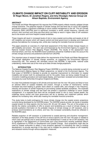
  • 3. th st FCRM>10, International Centre, Telford 28 June – 1 July 2010 Cliff instability involves slope failure and mass movement of a coastal slope or cliff and may result in the heave and deposition of debris on the beach and foreshore, noting that some landslides are large- scale and extend a considerable distance inland and offshore, and deep below beach level. Therefore, cliff instability and erosion in this context is a four stage process involving detachment of particles or blocks of material, the transport of this material through the cliff system, its deposition on the foreshore and its removal by wave and tidal action. Cliff recession is the landward retreat of the cliff profile (from cliff toe to cliff top) in response to cliff instability and erosion processes. It is not a simple or uniform process in space or time and depends on a variety of factors that control the rates of detachment and transport. 3. CLIFF BEHAVIOUR UNITS The concept of a cliff behaviour unit (CBU) provides an important framework for the investigation and management of cliffs (Lee 1997, Moore et al. 1998). Cliff behaviour units include the foreshore and the cliff top as these component landforms, and the processes that act upon them, can have a significant influence on cliff instability and recession behaviour. They are cascading systems or open sediment transport systems characterised by inputs, throughputs and outputs. Defra’s ‘Investigation and Management of Soft Rock Cliffs’ (Lee and Clark 2002) provides further background to the concept and classifies diagnostic CBUs according to their relative complexity, as follows: Figure 1 – CBU types in England and Wales: top left, Simple Cliff, Birling Gap East Sussex; top right, Composite Cliff, Purbeck Dorset; lower left, Simple Landslide, Scarborough North Yorkshire; lower right, Complex Cliff, Black Ven Dorset Simple cliff face systems: a single sequence of inputs from falls or slides leading almost directly to foreshore deposition. There is usually a steep cliff face, narrow degradation zone and rapid response to toe erosion. This type of cliff will fail as a result of toe erosion and undercutting, so relative sea level rise (RSLR) is the main forcing parameter. Examples include the Chalk cliffs of Sussex (Figure 1) and the hard rock cliffs of Cornwall. Simple landslide systems: a single sequence of inputs and outputs with variable amounts of storage. A marked degradation and storage zone is usually apparent affording limited buffering against toe erosion. This system will be affected by erosion of the landslide toe and excess groundwater in the slide zone; therefore both sea level and rainfall are key forcing parameters of equal importance. Examples include the cliffs formed in glacial tills in North Yorkshire (Figure 1) and the London Clay in Essex and Kent. 079.3
  • 4. th st FCRM>10, International Centre, Telford 28 June – 1 July 2010 Composite cliff systems: partly coupled sequences of contrasting simple sub-systems, typically comprising interbedded hard and soft rocks. Around the coast of England and Wales composite cliffs are formed where hard cap rocks are underlain by clayey strata giving a distinct steep upper cliff face and a tendency for high magnitude, low frequency failures. Composite cliffs are sensitive to changes in toe erosion and groundwater where soft rock occurs above hard rock. Examples include the till- capped cliffs of North Yorkshire and the hard rock capped cliffs of Purbeck and Portland (Figure 1). Figure 2 – Futurecoast CBU parameters and statistics (values in km) Complex cliff systems: strongly coupled sequences of scarp and bench sub-systems, each with their own inputs, storage and outputs of sediment. The output from one system forms a cascading input to the next resulting in close adjustment of process and form with complex feedbacks. The sub-system storage results in significant buffering against the immediate effects of toe erosion, although elevated groundwater levels can trigger major events that can transform the behaviour of the whole system (e.g. major mudsliding episodes), hence groundwater is the main forcing parameter in the short-term. 079.4
  • 5. th st FCRM>10, International Centre, Telford 28 June – 1 July 2010 The impact of toe erosion occurs over much longer timescales i.e. 100s or 1000s of years. Examples include the Ventnor Undercliff, Isle of Wight, and Black Ven, Dorset (Figure 1). Relict cliff systems: sequences of pre-existing landslides susceptible to reactivation and exhumation by coastal erosion operating over long timescales. They include abandoned cliffs and slopes formed by ancient landslides that have the potential to become reactivated by toe erosion and or excess groundwater levels. Examples include the Undercliffs at St Catherine’s Point, Isle of Wight, and Bindon, South Devon. The Futurecoast Cliffs Database (Halcrow 2002) provides a systematic assessment of the coastal cliffs of England and Wales in accordance with this CBU classification. Out of a total of 6,251km of coastline in England and Wales (NCERM database), 3,327km (53%) are cliffs subject to cliff instability and erosion. The database includes information on cliff materials, failure mechanisms, presence of cliff engineering and coastal defences, activity status, recession potential magnitude and frequency, sediment supply potential, sensitivity to climate change and uncertainty assessment (Figure 2). These data provide a valuable resource for cliff behaviour assessments and recession prediction studies. 4. CLIFF RECESSION PREDICTION Cliff behaviour assessment involves the measurement of historical and contemporary rates of cliff recession, consideration of the geological, geomorphological, geotechnical and hydrogeological controls, and the influence of coastal processes. At some sites, specific monitoring of cliff behaviour is carried out and there is now an increased awareness and commitment to carrying out strategic monitoring of the coastline and cliffs for scientific and management purposes (Bradbury 2001). In the past, most cliff recession studies were necessarily qualitative due to the lack of accurate spatial and temporal data, with heavy reliance given to expert judgement and the use of historical records where the errors in data and interpretation were neither quantified nor made explicit. Technology now exists to make better use of historical mapping and aerial photographs where the errors of data and interpretation of features can be quantified to a high degree of accuracy. In the context of a wider cliff behaviour assessment, use of a quantitative approach can significantly improve confidence with future projections of cliff recession (Moore et al. 2003). HISTORICAL AND CURRENT GEOLOGY AND CHANGES GEOMORPHOLOGY • Futurecoast • Futurecoast • SMP II • Academic papers • EA records • Geological Survey memoirs • Published papers and diaries • Consultants’ reports • Maps, DTMs & photos • Ground investigation data BEHAVIOUR MODEL PREDICTIVE MODEL: 100 YR RECESSION PROFILES Figure 3 – Cliff Behaviour and Prediction Model Framework To gain an understanding of coastal cliff behaviour, it is necessary to have some factual information on historical and current rates of change in the landform and of the geology and geomorphology. This information can then be used to develop a conceptual cliff behaviour model, encapsulating interacting geomorphic components, which can then be used to derive a predictive model (Figure 3). Future cliff behaviour is determined by the impact of changing system controls on past behaviour. Changing system controls include external factors, such as sea level rise and climate change, and 079.5
  • 6. th st FCRM>10, International Centre, Telford 28 June – 1 July 2010 internal factors such as variations in materials or hinterland geomorphology. The impact of changing system controls on the behaviour of coastal landforms can be determined by a range of approaches, including the following: • Extrapolation of historical data • Expert judgement, e.g. from cliff behaviour models • Probabilistic simulation modelling • Process-response simulation modelling • Empirical modelling These approaches involve an increasing degree of analysis, but do not necessarily provide an increasing level of accuracy. Furthermore, all approaches rely on the provision of historical recession rates, either as the basis for prediction or for model calibration. The ultimate precision of outputs is constrained by uncertainty over future climate and weather conditions, the physical properties and behaviour of the landform, the precise timing and magnitude of individual recession events and the future cliff recession rate. Walkden and Hall (2005) have developed a model, known as Soft Cliff and Platform Erosion (SCAPE) to represent the main processes that influence an eroding shoreline under RSLR. Lee (2005) provides a summary of the issues and a comparison of various deterministic and probabilistic approaches for cliff recession prediction, and presents a simple judgement-based model for evaluating cliff recession risk. These and other approaches are generally limited in their application by the absence of quality empirical datasets to quantify the relationships between cliff recession and the various controlling factors. An example is the relationship between historical cliff recession rates and sea level rise; Lee (2005) presents some data for the Suffolk coast but little is known about this relationship elsewhere along the coast of England and Wales. Similarly, only a few studies (e.g. Moore et al., 2007) have assembled datasets to quantify the effects of winter rainfall on coastal instability and landslides which are a major contributor to coastal recession at a number of key sites. Therefore, it is not possible to reliably model the effects of climate change on coastal cliffs using a quantitative modelling approach, particularly where this is based on extrapolation of past events alone. Such approaches do not take account of the potential uncertainty and variability of the cliff recession process. Consequently a judgment based assessment which brings together data concerning historical cliff behaviour with latest projections of UK climate change provides a pragmatic approach where the uncertainties can be explicitly expressed and accounted for, utilising numerical models as appropriate. A key objective of cliff behaviour assessment is not only to understand the materials, forms and processes of cliff systems but also their sensitivity to change and evolution through time. The timescales over which these factors are considered has a significant bearing on how the cliff instability and erosion process appears to have operated in historical times. The significance of past events and cliff recession rates need to be evaluated in this context. Lee and Clark (2002) identify three important timescales for cliff management purposes: 1. short-term, where recession can be a highly variable process 2. medium-term, where fluctuations are smoothed out and there is an apparent balance between form and process 3. long-term, where the nature and rates of cliff behaviour may change in response to internal and external influences, such as variations in lithology and sea level In the context of this study, it is important to note that certain CBUs will be characterised by frequent erosion (typically represented as an annual rate), whereas others will be characterised by less frequent (episodic) landslides, or indeed through a combination of both. These mechanisms and processes control the timing (frequency) and amount (magnitude) of cliff recession. The RACE and NCERM cliff recession prediction models provide a hierarchy of approaches in line with the above review (Table 2). These have increasing levels of complexity, providing incremental improvements in the quality of output, but also necessitating higher levels of data input, knowledge and time. Proportionate effort is therefore a consideration in deciding upon the technique to adopt. The description of each technique includes guidance on how it can be carried out, advice on suitability of use and limitations of the method. 079.6
  • 7. th st FCRM>10, International Centre, Telford 28 June – 1 July 2010 Technique General Description Main Points 1 Technical Experience based assessment for Quick and easy method. Crude Judgement use with minimal data examination. 2 Futurecoast Uses data from the Futurecoast Consistency of available data lends itself Assessment Cliffs Database to national application. 3 Site Specific Combines data from Futurecoast More accurate than Technique 2, although Assessment with real data (e.g. more up to some aspects remain imprecise. Some date aerial photographs) Local Authorities may already have such studies available. 4 Single Uses purely real data and Very robust method that will deliver Recession Rate methods recommended by the reliable results. Data requirements exceed Method SRC manual to calculate single Techniques 1 to 3. Methods require recession rates. extensive data and expert input. 5 Probabilistic Uses purely real data and Can provide most accurate output when Method methods recommended by the informed by good quality input data and SRC manual to calculate single expert input. recession rates. Table 2 – RACE/NCERM cliff recession prediction approaches 5. IMPACTS OF CLIMATE CHANGE (UKCP09) SCOPAC (Halcrow 2001) commissioned a landmark project to review the potential impacts of climate change along the south coast between Lyme Regis and Shoreham-by-Sea where it is anticipated that coastal flooding and erosion will present a significant challenge to future coastal management. The review highlighted that climate change is likely to result in changes to three key forcing agents including sea level rise, changes in wave direction and increased winter rainfall, with a tendency for more extreme events (Hosking and Moore 2002). The present study has reviewed these forcing parameters against the latest UKCP09 climate change projections (Table 3). To capture the full range of possibilities, climate change projections of RSLR and winter effective rainfall (WER) under high and low emissions scenarios (HES and LES) are considered. Neither of these parameters are directly output by UKCP09 and require interrogation and processing of projected datasets. Analysis of these projections revealed that projected changes in wave direction impact on cliffs in England and Wales was a relatively insignificant parameter compared to RSLR and WER. Furthermore, regional variations in projections were also found to be relatively insignificant and that the rate of change was broadly linear over the next 100 years across the full range of scenarios. The impact of RSLR and increased WER are likely to result in higher coastal erosion rates and more frequent coastal landslides. The rate of change of these impacts cannot be reliably quantified; however an estimate may be made by expert judgment. Whilst such judgements are based on limited empirical data, they represent the best available estimates and are informed by current data and knowledge of specific sites and the potential impacts of climate change (e.g. Lee 2005; Moore et al., 2007) based on this approach. Table 3 presents a matrix of estimated impacts of UKCP09 HES and LES projections on cliff erosion rates and cliff instability (landslide) frequency for cliffs of various sensitivity to climate change and sea level rise (from Futurecoast) over the next 100 years. Source Parameters UKCP09 LES UKCP09 HES UKCP09 Predicted rise in RSLR 26-37cm 40-51cm Predicted rise in WER 5-24% 9-40% Impact on ‘high’ Increase in cliff erosion rate 50-75% 50-100% sensitivity cliffs Increase in cliff instability and 100-200% 100-400% landslide frequency Impact on ‘medium’ Increase in cliff erosion rate 10-25% 10-50% sensitivity cliffs Increase in cliff instability and 20-50% 20-100% landslide frequency Impact on ‘low’ Increase in cliff erosion rate 0-5% 0-10% sensitivity cliffs Increase in cliff instability and 0-10% 0-20% landslide frequency Note: values in bold indicate the extremes of the ranges as used for validation of NCERM Table 3 – Estimated impact of UKCP09 scenarios on cliff instability and erosion 079.7
  • 8. th st FCRM>10, International Centre, Telford 28 June – 1 July 2010 6. NCERM VALIDATION AND CLIMATE CHANGE IMPACT ASSESSMENT This section presents the findings of the review and validation of historical cliff behaviour and cliff recession projection of 172 CBUs which form 22 priority sites (Figure 4). These sites form a small sub- set of a total of 116 sites identified by Futurecoast as ‘high’ sensitivity to climate change. They were selected due to the availability of site-specific data on cliff instability and erosion from Halcrow’s project archives which provide independent validation of the Futurecoast and NCERM datasets. Figure 4 – NCERM validation sites 079.8
  • 9. th st FCRM>10, International Centre, Telford 28 June – 1 July 2010 The main objectives of the site-specific validation and review of cliff recession projections accounting for climate change were as follows: 1. Review of the defined NCERM CBU extents, and the relative significance of annual toe erosion and the magnitude and frequency of cliff instability and landslide events that govern future cliff recession. 2. Development of rule sets for validation and cliff recession prediction for Complex and Non- Complex Cliffs accounting for the impacts of climate change (principally RSLR and WER). 3. Critical review of long-term historical cliff recession rates and landslide event magnitude and frequency, and determination of validated empirical values for use by NCERM. 4. Independent projection of future cliff recession accounting for UKCP09 HES and LES climate change impacts and comparison with non-validated NCERM projections. Non-Complex Cliffs For simple cliffs, simple landslides and composite cliffs considered in this assessment, a simplified assumption is made that future cliff recession will be driven by toe erosion. Therefore, these CBU types are treated together as ‘non-complex cliffs’. By definition, these cliff types are characterised by various rates of cliff toe erosion which is generally in balance and equal to the rate of cliff top recession (Lee & Clark 2002). The feedback mechanism from the point of toe erosion to cliff top recession is in many cases subject to delay or time-lag. However, the frequency of erosion and landslide events is sufficiently high or short-term (i.e. <1:100 years) to be accounted for by assessments of long term historical erosion dating back to the 19th Century. Thus, for non-complex cliffs it is appropriate to use the historical annual cliff recession rate as a basis for future prediction. The first step in calculating projected recession distances for non-complex cliffs is to validate the baseline historical recession rate. This baseline is taken to be the long-term historical value derived from accurate measurement of historical maps and aerial photographs of the site (Table 4). For example, the validated long-term historical recession rate for Site 19: Happisburgh is 3.25m/yr. This baseline rate is projected to increase over the next 100 years due to the impact of climate change on high sensitivity cliffs subject to erosion (Table 3). Thus, the recession rate under the UKCP09 HES is incremented by 1% per year, so that by year 100 the rate has increased by a total of 100% i.e. 6.5m/yr; note that this value is the upper bound increase projected under the full range of UKCP09 scenarios. The cumulative recession distance year on year is then calculated up to year 100. This allows projected recession distances for 20, 50 and 100 years under UKCP09 low and high emissions scenarios to be determined (Table 4). Site Site Location Validated Projected cliff recession rate under No. historical cliff UKCP09 HES (m/yr) recession rate 2029 2059 2109 (m/yr) 1 Barn Scar & Carl Crag, Cumbria 0.25 0.3 0.38 0.5 Whitriggs Scar, Cumbria 0.18 0.21 0.27 0.36 2 Barton to Naish Farm, 1.03 1.23 1.55 2.06 Hampshire Mundesley to Bacton Green, 3 0.9 - 1.51 1.08 - 1.81 1.35 - 2.27 1.80 - 3.02 Norfolk 4 Swanage Bay, Dorset 0.09 0.11 0.14 0.18 5 Church Cliff, Dorset 0.2 0.24 0.3 0.4 6 Higher Sea Lane, Dorset 1.5 1.8 2.25 3.0 11 St.Bees/Pow Beck, Cumbria 0.59 0.71 0.89 1.18 12 Nethertown, Cumbria 0.07 0.08 0.11 0.14 14 Swanage, Dorset 0.3 0.36 0.45 0.6 16 South coast, Isle of Wight 0.11 - 0.41 0.13 - 0.49 0.17 - 0.62 0.22 - 0.82 17 Southeast coast, Isle of Wight 0.26 0.31 0.39 0.52 18 Fairlight, East Sussex 0.64 0.77 0.96 1.28 19 Happisburgh, Norfolk 3.25 3.90 4.88 6.50 20 Cayton Bay, North Yorkshire 1.0 1.20 1.50 2.0 21 & 22 Filey South 0.2 - 1.0 0.24 - 1.2 0.30 - 1.5 0.40 - 2.0 Note: for multiple CBUs where variations in geology are significant the range of cliff recession rates is quoted Table 4 – Validated cliff recession rates and HES projections for non-complex cliffs 079.9
  • 10. th st FCRM>10, International Centre, Telford 28 June – 1 July 2010 The percentage increase in annual recession due to climate change is applied linearly to 2080 yet NCERM projections are provided to 2109. For the purposes of this assessment, the percentage increases in recession due to climate change are applied for the next 100 years, to 2109, in line with NCERM; however, it is noted that this involves projection of the UKCP09 climate change projections beyond their intended time limit and as a consequence may under-estimate the full impact of climate change on cliff recession beyond 2080, which is uncertain. Site Site Location Validated Validated Projected landslide frequency under No. landslide landslide UKCP09 HES (years) magnitude frequency 2029 2059 2109 (m) (years) 2 Barton, Hampshire 2-5 5 - 13 5 - 13 3.3 - 8.7 2.5 – 6.5 East Cliff, Spittles & 5&6 30 - 50 25 - 30 25 - 30 8.3 - 10 5-6 Black Ven, Dorset Warden Point, Isle of 7 30 35 - 50 35 - 50 12 - 17 7 - 10 Sheppey, Kent Covehurst Bay, 8 60 50 50 17 10 Fairlight, East Sussex Ventnor Undercliff, 9 50 500* 500 500 500 Isle of Wight* Cayton Cliff, North 10 10 40 40 13 8 Yorkshire St Bees/Pow Beck, 11 50 500 500 167 100 Cumbria 13 Lyme Bay, Dorset 30 - 92 30 - 500 30 - 500 10 - 167 6 - 100 Gurnard Ledge, Isle 15 15 50 - 500* 50 - 500 16.7 - 500 10 - 500 of Wight South coast, Isle of 16 20 - 50 50 - 500* 50 - 500 16.7 - 500 10 - 500 Wight Southeast coast, Isle 17 10 - 50 10 - 500* 10 - 500 3.3 - 500 2 - 500 of Wight 18 Fairlight, East Sussex 10 50 50 16.7 10 Filey South, North 22 10 10 10 3.3 2 Yorkshire *denotes CBUs where landsliding frequency is historically very low and where the impact of climate change is not expected to be significant over the next 100 years Table 5 – Validated magnitude and frequency and HES projections for complex cliffs Complex Cliffs For complex cliffs (Figure 4), the frequency and magnitude of episodic landslide events, caused by long-term coastal erosion and site-specific ground conditions, are dominant controls of cliff top recession. Many of the UK’s complex and relict coastal landslide systems are many thousands of years old and have remained dormant over the historical period. However, they are subject to ground movement, reactivation and occasional landslide events which pose a risk to development and infrastructure located upon them. An important feature of these systems is the presence of a rear scarp some distance inland of the sea-cliff or landslide toe; erosion of the landslide toe and adverse ground conditions potentially influences recession of the rear scarp, therefore, an important consideration of such assessments is to accurately map the full extent of complex cliffs. This is often a shortcoming of SMPs and other regional cliff studies. 079.10
  • 11. th st FCRM>10, International Centre, Telford 28 June – 1 July 2010 For complex systems where annual erosion rate is used alone for future projection, it is likely that this may lead to significant under-prediction of future cliff recession where change is driven by episodic large-scale landslide events. Conversely, applying both annual erosion and episodic landslide events recession may lead to over-prediction. Thus for complex cliffs, landslide magnitude and frequency only are used as a basis for prediction of future cliff recession. The first step in calculating projected future recession distances for complex cliffs is to validate the historical landslide frequency (Table 5). The validated landslide frequency is then converted to an annual probability. The annual probability is then modelled to increase with climate change (Table 3), with the total increase in landslide frequency achieved by year 100. The increase in landslide frequency is applied linearly to 2109; however, this involves projection of UKCP09 data beyond their intended timeframe and as a consequence may under-estimate the full impact of climate change on landslide frequency beyond 2080, which is uncertain. Cumulative probabilities are then calculated; when the cumulative probability is equal to 1 a landslide event and associated cliff recession will have occurred. It is not possible to precisely predict the next landslide occurrence so it is assumed the first landslide event in the series occurs in year 1. By multiplying the number of landslide occurrences within each time frame (20, 50, 100 years) with landslide magnitude, the amount of cliff recession is determined for LES and HES climate projections. This is a generic approach applied to all complex cliffs where recession of the headscarp is expected as a result of episodic coastal instability and erosion in the next 100 years. The exceptions to the rule are those CBUs where headscarp recession is not expected in the next 100 years and for these cases the projected recession distance is set to 0m. Despite the lack of headscarp recession of some complex cliffs they remain at risk of coastal instability and erosion at any time involving toe erosion, ongoing ground movement and periodic landslides within the mapped extent of the cliff system. 7. Results and Discussion The results of the cliff behaviour assessment and validation of 22 priority sites has revealed the following. There is close agreement between NCERM and independently validated cliff recession projections for high sensitivity non-complex cliffs where there is a relatively direct link between toe erosion and cliff top recession rates. The NCERM projections (defined by best and worst case) have sufficient range or contingency to account for UKCP09 climate change scenarios up to 50 years from now and in many cases up to 100 years from now. This is a significant outcome of the study as it confirms that NCERM, a high-profile, national scale undertaking, accounts for the most up-to-date climate change projections for about 90% of the cliffs database for England and Wales. Complex cliffs comprise less than 10% of the cliffs database and nearly half of these are rated as high-sensitivity to climate change (Figure 2). They are characterised by an indirect and delayed response between toe erosion and cliff top recession controlled by site-specific ground conditions and excess groundwater levels triggering episodic large landslide events; individual CBUs have unique historical cliff behaviour and sensitivity to future climate change and sea level rise. The results of independent validation and recession projection for high-sensitivity complex cliffs have revealed significant differences with NCERM projections. The differences are randomly distributed and highlight issues regarding mapping of complex cliff extents, and validation of appropriate landslide magnitude and frequency values. The majority of NCERM projections show significant under- prediction of potential cliff recession for complex cliffs and generally do not have sufficient range or contingency to account for UKCP09 LES and HES under any timeframe; further it is not considered realistic to modify NCERM to account for climate change without introducing orders of magnitude of uncertainty in future cliff recession projections. Therefore, complex cliffs should be considered a special case and assessed on their individual merits as toe erosion is not necessarily the main driver of cliff top recession in the short- and medium-term, a recommendation which is being taken forward by NCERM. ACKNOWLEDGEMENTS The authors are grateful to the Environment Agency for permission to publish this work. The contributions of colleagues at Halcrow Group Ltd are also acknowledged. REFERENCES Bradbury A (2001). Strategic monitoring of the coastal zone - towards a regional approach. Proc. 36th DEFRA Conf. of River and Coastal Engineers, 5.2.1-13. 079.11
  • 12. th st FCRM>10, International Centre, Telford 28 June – 1 July 2010 Halcrow Group Ltd. (2001). Preparing for the Impacts of Climate Change: a strategy for long term planning and management of the shoreline in the context of climate change. Summary report and CD of full report prepared on behalf of SCOPAC. Halcrow Group Ltd. (2002). Futurecoast. DEFRA. Halcrow Group Ltd. (2006). Risk Assessment of Coastal Erosion. Technical report (2 vols) to DEFRA. Hosking ASD and Moore R (2002). Preparing for the impacts of climate change on the central south coast of England. In RG McInnes and J Jakeways (eds) Instability, Planning and Management: seeking sustainable solutions to ground movement problems, Thomas Telford, 2002. P601-08. Lee E M and Clark A R 2002. Investigation and management of soft rock cliffs. Thomas Telford. Lee EM (1997). The investigation and management of soft rock cliffs. Proc. MAFF Conf. of River and Coastal Engineers, B.1.1-12. Lee EM (2005). Coastal cliff recession risk: a simple judgement-based model. Quarterly Journal of Engineering Geology and Hydrogeology 38, 89-104. Moore R, Carey J, McInnes RG & Houghton J (2007). Climate change, so what? Implications for ground movement and landslide event frequency in the Ventnor Undercliff, Isle of Wight. Proc. Int. Conf. on Landslides and Climate Change, Ventnor, Isle of Wight. P335-344. Moore R, Clark AR and Lee EM (1998). Coastal Cliff Behaviour and Management: Blackgang, Isle of Wight. In: Maund JG and Eddlestone M (eds.) Geohazards in Engineering Geology. Geological Society, London, Engineering Geology Special Publications, 15; 49-59. Moore R, Fish P, Glennerster M & Bradbury A (2003). Cliff behaviour assessment: a quantitative th approach using digital photogrammetry and GIS. Proc. 38 DEFRA Conf. of River and Coastal Engineers, 08.3.1-08.3.13, 2003. Walkden MJA and Hall JW (2005). A predictive Mesoscale model of the erosion and profile development of soft rock shores. Coastal Engineering 2005, 52(6), 535-563. 079.12