Contenu connexe
Plus de Smartgo Leicester
Plus de Smartgo Leicester (14)
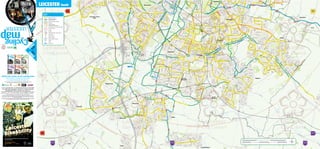
Leicester south
- 1. LEICESTER South
KEY
Recommended route
National Cycle Network
On-road / Off-road
Off-road surfaced / unsurfaced
Bridleway
Pedestrian street /
with resticted vehicle access
LEICESTER Footway where you should walk your bike
On-road cycle lane
map Bus lane
One way
Railway with station / Level crossing
Cycle parking
Toucan crossing
Pelican crossing
Aylestone
Meadows
Cycling School / College / University
Hospital
Library
Park and ride
FR N 1
EE
o
N
o
FR
1 E
FR N 3
FR N 2
FR N 1
Cycling Cycling
o
o
o
EE
EE
EE
E
Cycling
BRIXHAM DR
LEICESTER
map map map
LOUGHBOROUGH MELTON MOWBRAY
IVE
AREA AREA
a great place t
a great place to o li
ve
live
a
and
www.leics.gov.uk/cycling
www.leics.gov.uk/cycling
nd
visit
visit
FR N 4
FR N 6
Cycling Cycling
o
o
EE
EE
map map
MARKET HARBOROUGH
and Lutterworth Area
COALVILLE AREA
and The National Forest
a great place to a great place t
live o li
a ve
nd
and
visit
www.leics.gov.uk/cycling
www.leics.gov.uk/cycling
visit
Collect the series of six cycling maps
Latest versions available for download
at www.leicester.gov.uk/cycle-city
This map has been prepared in consultation with Leicester Cycle-city Workshop representing
bike projects, clubs and organisations supporting cycling across Leicester.
If you would like help in understanding the text on this leaflet
in an alternative language or require it in a larger font/audio
format please contact Leicester City Council on
0116 252 7000. The map section can be enlarged if required.
Users of these routes do so at their own risk. Refer to the good cycling tips inside this leaflet.
Designed by Leicestershire County Council Creative Services Section. Tel: 0116 305 6273.
Published by CycleCity Guides for Leicesters City Council February 2011. CycleCity Guides, The Welshmill, Park Hill Drive,
Frome, Somerset, BA11 2LE. www.cyclecityguides.co.uk. This map is based upon Ordnance Survey material with the permission
of Ordnance Survey on behalf of the controller of Her Majesty’s Stationery Office © Crown copyright and database rights 2011
Ordnance Survey 1000192264
The representation of a track or a path is no evidence of a public right of way. Users of all routes shown on this map do so entirely
at their own risk. We cannot guarantee that all routes and bridleways will always be passable by bike particularly in wet weather.
Leicester City Council and CycleCity Guides accept no responsibility for omissions or errors.
0 Miles 0.5 1 1.5
0116 2527000 0 Kilometers 0.5 1 1.5 2 2.5