SlideShare une entreprise Scribd logo
1  sur  2
Télécharger pour lire hors ligne
Sensors and Their Specifications


Thematic Mapper (TM)
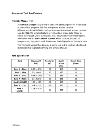
       A Thematic Mapper (TM) is one of the Earth observing sensors introduced
       in the Landsat program. The first was placed aboard Landsat
       4 (decommissioned in 2001), and another was operational aboard Landsat
       5 up to 2012. TM sensors feature seven bands of image data (three in
       visible wavelengths, four in infrared) most of which have 30 meter spatial
       resolution. TM is a whisk broom scanner which takes multi-spectral
       images across its ground track. It does not directly produce a thematic map.
       The Thematic Mapper has become a useful tool in the study of albedo and
       its relationship to global warming and climate change.


Band Specification

        Band         Wavelength      Resolution    Swath        Revisit time
                       (µm)             (m)        Width          (days)
                                                    (km)
   Band 1 (Blue)      0.45 to 0.52       30          185             16
    Band 2 (Gr)       0.52 to 0.6        30          185             16
   Band 3 (Red)       0.63 to 0.69       30          185             16
   Band 4 (NIR)       0.76 to 0.9        30          185             16
  Band 5 (SWIR)       1.55 to 1.75       30          185             16
   Band 6 (TIR)       10.4 to 12.5      120          185             16
      Band 7          2.08 to 2.35
                                         30          185             16
      (SWIR)


S K Diwakar
Sensors and Their Specifications


Enhanced Thematic Mapper (ETM+)

       ETM+ is similar to TM, but has a higher spatial resolution thermal channel
       and includes a new panchromatic channel. These satellites have a polar,
       circular, sun-synchronous 705-km orbit with a 16-day repeat cycle. The TM
       swath width is 185 km.

Band Specification


              Band             Wavelength Region (µm)        Resolution (m)

               1                   0.450-0.515 (blue)              30

               2                   0.525-0.605 (green)             30

               3                    0.630-0.690 (red)              30

               4                0.750-0.900 (near-IR)              30

               5                   1.55-1.75 (mid-IR)              30

               6                10.4-12.5 (thermal-IR)             60

               7                   2.08-2.35 (mid-IR)              30

              PAN                      0.52-0.90                   15


S K Diwakar

Contenu connexe

Tendances

Fundamentals of Remote Sensing
Fundamentals of Remote Sensing Fundamentals of Remote Sensing
Fundamentals of Remote Sensing
Pallab Jana
 
. Atmospheric window and reflectance curve
. Atmospheric window and  reflectance curve. Atmospheric window and  reflectance curve
. Atmospheric window and reflectance curve
marutiChilame
 

Tendances (20)

Digital image processing
Digital image processingDigital image processing
Digital image processing
 
Microwave remote sensing
Microwave remote sensingMicrowave remote sensing
Microwave remote sensing
 
Visual Interpretation
Visual InterpretationVisual Interpretation
Visual Interpretation
 
1 remote sensing
1 remote sensing1 remote sensing
1 remote sensing
 
Remote sensing
Remote sensingRemote sensing
Remote sensing
 
Remote Sensing Platforms and Sensors
Remote Sensing Platforms and SensorsRemote Sensing Platforms and Sensors
Remote Sensing Platforms and Sensors
 
Basics of Remote Sensing
Basics of Remote SensingBasics of Remote Sensing
Basics of Remote Sensing
 
Remote sensing
 Remote sensing Remote sensing
Remote sensing
 
Fundamentals of Remote Sensing
Fundamentals of Remote Sensing Fundamentals of Remote Sensing
Fundamentals of Remote Sensing
 
Chapter 1 (Introduction to remote sensing)
Chapter 1 (Introduction to remote sensing)Chapter 1 (Introduction to remote sensing)
Chapter 1 (Introduction to remote sensing)
 
Image interpretation keys & image resolution
Image interpretation keys & image resolutionImage interpretation keys & image resolution
Image interpretation keys & image resolution
 
Band ratioing presentation
Band ratioing presentationBand ratioing presentation
Band ratioing presentation
 
. Atmospheric window and reflectance curve
. Atmospheric window and  reflectance curve. Atmospheric window and  reflectance curve
. Atmospheric window and reflectance curve
 
Remote sensing-presentaion
Remote sensing-presentaionRemote sensing-presentaion
Remote sensing-presentaion
 
INTRODUCTION TO REMOTE SENSING
 INTRODUCTION TO REMOTE SENSING INTRODUCTION TO REMOTE SENSING
INTRODUCTION TO REMOTE SENSING
 
hyperspectral remote sensing and its geological applications
hyperspectral remote sensing and its geological applicationshyperspectral remote sensing and its geological applications
hyperspectral remote sensing and its geological applications
 
Basic remote sensing and gis
Basic remote sensing and gisBasic remote sensing and gis
Basic remote sensing and gis
 
Scale and resolution
Scale and resolutionScale and resolution
Scale and resolution
 
Remote sensing
Remote sensingRemote sensing
Remote sensing
 
Remote Sensing ppt
Remote Sensing pptRemote Sensing ppt
Remote Sensing ppt
 

Similaire à Thematic mapper

1Resolutions of Remote Sensing1. Spatial (what area an.docx
1Resolutions of Remote Sensing1. Spatial (what area an.docx1Resolutions of Remote Sensing1. Spatial (what area an.docx
1Resolutions of Remote Sensing1. Spatial (what area an.docx
aulasnilda
 
Lrm 111 intro remote sensing lesson iv
Lrm 111 intro remote sensing lesson ivLrm 111 intro remote sensing lesson iv
Lrm 111 intro remote sensing lesson iv
musadoto
 
nisizawa_IGARSS_HSRL_FR2.T07.ppt
nisizawa_IGARSS_HSRL_FR2.T07.pptnisizawa_IGARSS_HSRL_FR2.T07.ppt
nisizawa_IGARSS_HSRL_FR2.T07.ppt
grssieee
 
Sareic mauger
Sareic maugerSareic mauger
Sareic mauger
Brett Johnson
 
Polarimetric Study of emission nebulea Stock 8 in Auriga
Polarimetric Study of emission nebulea Stock 8 in AurigaPolarimetric Study of emission nebulea Stock 8 in Auriga
Polarimetric Study of emission nebulea Stock 8 in Auriga
rahulporuri
 
CROSS-COMPARISON BETWEEN CHINA HJ1A-CCD AND LANDSAT TM DATA(Guoqing Li).ppt
CROSS-COMPARISON BETWEEN CHINA HJ1A-CCD AND LANDSAT TM DATA(Guoqing Li).pptCROSS-COMPARISON BETWEEN CHINA HJ1A-CCD AND LANDSAT TM DATA(Guoqing Li).ppt
CROSS-COMPARISON BETWEEN CHINA HJ1A-CCD AND LANDSAT TM DATA(Guoqing Li).ppt
grssieee
 
CROSS-COMPARISON BETWEEN CHINA HJ1A-CCD AND LANDSAT TM DATA(Guoqing Li).ppt
CROSS-COMPARISON BETWEEN CHINA HJ1A-CCD AND LANDSAT TM DATA(Guoqing Li).pptCROSS-COMPARISON BETWEEN CHINA HJ1A-CCD AND LANDSAT TM DATA(Guoqing Li).ppt
CROSS-COMPARISON BETWEEN CHINA HJ1A-CCD AND LANDSAT TM DATA(Guoqing Li).ppt
grssieee
 

Similaire à Thematic mapper (20)

1Resolutions of Remote Sensing1. Spatial (what area an.docx
1Resolutions of Remote Sensing1. Spatial (what area an.docx1Resolutions of Remote Sensing1. Spatial (what area an.docx
1Resolutions of Remote Sensing1. Spatial (what area an.docx
 
Platforms of Remote sensing and GIS
Platforms of Remote sensing and GISPlatforms of Remote sensing and GIS
Platforms of Remote sensing and GIS
 
Remote sensing satellites with sensors
Remote sensing satellites with sensorsRemote sensing satellites with sensors
Remote sensing satellites with sensors
 
Lrm 111 intro remote sensing lesson iv
Lrm 111 intro remote sensing lesson ivLrm 111 intro remote sensing lesson iv
Lrm 111 intro remote sensing lesson iv
 
nisizawa_IGARSS_HSRL_FR2.T07.ppt
nisizawa_IGARSS_HSRL_FR2.T07.pptnisizawa_IGARSS_HSRL_FR2.T07.ppt
nisizawa_IGARSS_HSRL_FR2.T07.ppt
 
MODIS
MODISMODIS
MODIS
 
Sareic mauger
Sareic maugerSareic mauger
Sareic mauger
 
Iirs rstechnologypdf
Iirs rstechnologypdfIirs rstechnologypdf
Iirs rstechnologypdf
 
;
;;
;
 
Polarimetric Study of emission nebulea Stock 8 in Auriga
Polarimetric Study of emission nebulea Stock 8 in AurigaPolarimetric Study of emission nebulea Stock 8 in Auriga
Polarimetric Study of emission nebulea Stock 8 in Auriga
 
CROSS-COMPARISON BETWEEN CHINA HJ1A-CCD AND LANDSAT TM DATA(Guoqing Li).ppt
CROSS-COMPARISON BETWEEN CHINA HJ1A-CCD AND LANDSAT TM DATA(Guoqing Li).pptCROSS-COMPARISON BETWEEN CHINA HJ1A-CCD AND LANDSAT TM DATA(Guoqing Li).ppt
CROSS-COMPARISON BETWEEN CHINA HJ1A-CCD AND LANDSAT TM DATA(Guoqing Li).ppt
 
CROSS-COMPARISON BETWEEN CHINA HJ1A-CCD AND LANDSAT TM DATA(Guoqing Li).ppt
CROSS-COMPARISON BETWEEN CHINA HJ1A-CCD AND LANDSAT TM DATA(Guoqing Li).pptCROSS-COMPARISON BETWEEN CHINA HJ1A-CCD AND LANDSAT TM DATA(Guoqing Li).ppt
CROSS-COMPARISON BETWEEN CHINA HJ1A-CCD AND LANDSAT TM DATA(Guoqing Li).ppt
 
Remote Sensing - Operating Satellites
Remote Sensing -  Operating SatellitesRemote Sensing -  Operating Satellites
Remote Sensing - Operating Satellites
 
Spectral data fusion for quantitative assessment of soils from Brazil, Dr. Fa...
Spectral data fusion for quantitative assessment of soils from Brazil, Dr. Fa...Spectral data fusion for quantitative assessment of soils from Brazil, Dr. Fa...
Spectral data fusion for quantitative assessment of soils from Brazil, Dr. Fa...
 
Aa19213 12
Aa19213 12Aa19213 12
Aa19213 12
 
03 Landsat Legacy.pptx
03 Landsat Legacy.pptx03 Landsat Legacy.pptx
03 Landsat Legacy.pptx
 
Presentation on the background theory of InSAR
Presentation on the background theory of InSARPresentation on the background theory of InSAR
Presentation on the background theory of InSAR
 
Remote sensing and image interpretation
Remote sensing and image interpretationRemote sensing and image interpretation
Remote sensing and image interpretation
 
Innelastic Light Scattering in Carbon Nanostructures: from the micro to the n...
Innelastic Light Scattering in Carbon Nanostructures: from the micro to the n...Innelastic Light Scattering in Carbon Nanostructures: from the micro to the n...
Innelastic Light Scattering in Carbon Nanostructures: from the micro to the n...
 
Pohl & van genderen 2017 pp.8-13 table 1.2 popular optical remote sensing pla...
Pohl & van genderen 2017 pp.8-13 table 1.2 popular optical remote sensing pla...Pohl & van genderen 2017 pp.8-13 table 1.2 popular optical remote sensing pla...
Pohl & van genderen 2017 pp.8-13 table 1.2 popular optical remote sensing pla...
 

Plus de Sumant Diwakar

Solar irradiation & spectral signature
Solar irradiation & spectral signatureSolar irradiation & spectral signature
Solar irradiation & spectral signature
Sumant Diwakar
 
Optical remote sensing
Optical remote sensingOptical remote sensing
Optical remote sensing
Sumant Diwakar
 
Interaction of EMR with atmosphere and earth surface
Interaction of EMR with atmosphere and earth surfaceInteraction of EMR with atmosphere and earth surface
Interaction of EMR with atmosphere and earth surface
Sumant Diwakar
 
History of remote sensing
History of remote sensingHistory of remote sensing
History of remote sensing
Sumant Diwakar
 
Electromagnetic radiation
Electromagnetic radiationElectromagnetic radiation
Electromagnetic radiation
Sumant Diwakar
 
Differential gps (dgps) 09 04-12
Differential gps (dgps) 09 04-12Differential gps (dgps) 09 04-12
Differential gps (dgps) 09 04-12
Sumant Diwakar
 
Principle of photogrammetry
Principle of photogrammetryPrinciple of photogrammetry
Principle of photogrammetry
Sumant Diwakar
 
Automatic digital terrain modelling
Automatic digital terrain modellingAutomatic digital terrain modelling
Automatic digital terrain modelling
Sumant Diwakar
 
Aerial photography abraham thomas
Aerial photography abraham thomasAerial photography abraham thomas
Aerial photography abraham thomas
Sumant Diwakar
 
Aerial photographs and their interpretation
Aerial photographs and their interpretationAerial photographs and their interpretation
Aerial photographs and their interpretation
Sumant Diwakar
 

Plus de Sumant Diwakar (20)

Hydrologic Assessment in a Middle Narmada Basin, India using SWAT Model
Hydrologic Assessment in a Middle Narmada Basin, India using SWAT ModelHydrologic Assessment in a Middle Narmada Basin, India using SWAT Model
Hydrologic Assessment in a Middle Narmada Basin, India using SWAT Model
 
C Programming
C ProgrammingC Programming
C Programming
 
C Programming
C ProgrammingC Programming
C Programming
 
Soil moisture
Soil moistureSoil moisture
Soil moisture
 
REMOTE SENSING & GIS APPLICATIONS IN WATERSHED MANAGEMENT
REMOTE SENSING & GIS APPLICATIONS IN WATERSHED MANAGEMENT REMOTE SENSING & GIS APPLICATIONS IN WATERSHED MANAGEMENT
REMOTE SENSING & GIS APPLICATIONS IN WATERSHED MANAGEMENT
 
Relation between Ground-based Soil Moisture and Satellite Image-based NDVI
Relation between Ground-based Soil Moisture and Satellite Image-based NDVIRelation between Ground-based Soil Moisture and Satellite Image-based NDVI
Relation between Ground-based Soil Moisture and Satellite Image-based NDVI
 
Solar irradiation & spectral signature
Solar irradiation & spectral signatureSolar irradiation & spectral signature
Solar irradiation & spectral signature
 
Optical remote sensing
Optical remote sensingOptical remote sensing
Optical remote sensing
 
Interaction of EMR with atmosphere and earth surface
Interaction of EMR with atmosphere and earth surfaceInteraction of EMR with atmosphere and earth surface
Interaction of EMR with atmosphere and earth surface
 
History of remote sensing
History of remote sensingHistory of remote sensing
History of remote sensing
 
Electromagnetic radiation
Electromagnetic radiationElectromagnetic radiation
Electromagnetic radiation
 
Map projection
Map projectionMap projection
Map projection
 
Differential gps (dgps) 09 04-12
Differential gps (dgps) 09 04-12Differential gps (dgps) 09 04-12
Differential gps (dgps) 09 04-12
 
Principle of photogrammetry
Principle of photogrammetryPrinciple of photogrammetry
Principle of photogrammetry
 
Digital terrain model
Digital terrain modelDigital terrain model
Digital terrain model
 
Digital orthophoto
Digital orthophotoDigital orthophoto
Digital orthophoto
 
Automatic digital terrain modelling
Automatic digital terrain modellingAutomatic digital terrain modelling
Automatic digital terrain modelling
 
Aerial photography abraham thomas
Aerial photography abraham thomasAerial photography abraham thomas
Aerial photography abraham thomas
 
Aerial photographs and their interpretation
Aerial photographs and their interpretationAerial photographs and their interpretation
Aerial photographs and their interpretation
 
Wide field sensor
Wide field sensorWide field sensor
Wide field sensor
 

Dernier

The basics of sentences session 3pptx.pptx
The basics of sentences session 3pptx.pptxThe basics of sentences session 3pptx.pptx
The basics of sentences session 3pptx.pptx
heathfieldcps1
 
1029-Danh muc Sach Giao Khoa khoi 6.pdf
1029-Danh muc Sach Giao Khoa khoi  6.pdf1029-Danh muc Sach Giao Khoa khoi  6.pdf
1029-Danh muc Sach Giao Khoa khoi 6.pdf
QucHHunhnh
 
Activity 01 - Artificial Culture (1).pdf
Activity 01 - Artificial Culture (1).pdfActivity 01 - Artificial Culture (1).pdf
Activity 01 - Artificial Culture (1).pdf
ciinovamais
 
Beyond the EU: DORA and NIS 2 Directive's Global Impact
Beyond the EU: DORA and NIS 2 Directive's Global ImpactBeyond the EU: DORA and NIS 2 Directive's Global Impact
Beyond the EU: DORA and NIS 2 Directive's Global Impact
PECB
 

Dernier (20)

Sociology 101 Demonstration of Learning Exhibit
Sociology 101 Demonstration of Learning ExhibitSociology 101 Demonstration of Learning Exhibit
Sociology 101 Demonstration of Learning Exhibit
 
Advanced Views - Calendar View in Odoo 17
Advanced Views - Calendar View in Odoo 17Advanced Views - Calendar View in Odoo 17
Advanced Views - Calendar View in Odoo 17
 
Ecological Succession. ( ECOSYSTEM, B. Pharmacy, 1st Year, Sem-II, Environmen...
Ecological Succession. ( ECOSYSTEM, B. Pharmacy, 1st Year, Sem-II, Environmen...Ecological Succession. ( ECOSYSTEM, B. Pharmacy, 1st Year, Sem-II, Environmen...
Ecological Succession. ( ECOSYSTEM, B. Pharmacy, 1st Year, Sem-II, Environmen...
 
psychiatric nursing HISTORY COLLECTION .docx
psychiatric  nursing HISTORY  COLLECTION  .docxpsychiatric  nursing HISTORY  COLLECTION  .docx
psychiatric nursing HISTORY COLLECTION .docx
 
Grant Readiness 101 TechSoup and Remy Consulting
Grant Readiness 101 TechSoup and Remy ConsultingGrant Readiness 101 TechSoup and Remy Consulting
Grant Readiness 101 TechSoup and Remy Consulting
 
The basics of sentences session 3pptx.pptx
The basics of sentences session 3pptx.pptxThe basics of sentences session 3pptx.pptx
The basics of sentences session 3pptx.pptx
 
1029-Danh muc Sach Giao Khoa khoi 6.pdf
1029-Danh muc Sach Giao Khoa khoi  6.pdf1029-Danh muc Sach Giao Khoa khoi  6.pdf
1029-Danh muc Sach Giao Khoa khoi 6.pdf
 
Introduction to Nonprofit Accounting: The Basics
Introduction to Nonprofit Accounting: The BasicsIntroduction to Nonprofit Accounting: The Basics
Introduction to Nonprofit Accounting: The Basics
 
Activity 01 - Artificial Culture (1).pdf
Activity 01 - Artificial Culture (1).pdfActivity 01 - Artificial Culture (1).pdf
Activity 01 - Artificial Culture (1).pdf
 
2024-NATIONAL-LEARNING-CAMP-AND-OTHER.pptx
2024-NATIONAL-LEARNING-CAMP-AND-OTHER.pptx2024-NATIONAL-LEARNING-CAMP-AND-OTHER.pptx
2024-NATIONAL-LEARNING-CAMP-AND-OTHER.pptx
 
Measures of Dispersion and Variability: Range, QD, AD and SD
Measures of Dispersion and Variability: Range, QD, AD and SDMeasures of Dispersion and Variability: Range, QD, AD and SD
Measures of Dispersion and Variability: Range, QD, AD and SD
 
Web & Social Media Analytics Previous Year Question Paper.pdf
Web & Social Media Analytics Previous Year Question Paper.pdfWeb & Social Media Analytics Previous Year Question Paper.pdf
Web & Social Media Analytics Previous Year Question Paper.pdf
 
Role Of Transgenic Animal In Target Validation-1.pptx
Role Of Transgenic Animal In Target Validation-1.pptxRole Of Transgenic Animal In Target Validation-1.pptx
Role Of Transgenic Animal In Target Validation-1.pptx
 
Asian American Pacific Islander Month DDSD 2024.pptx
Asian American Pacific Islander Month DDSD 2024.pptxAsian American Pacific Islander Month DDSD 2024.pptx
Asian American Pacific Islander Month DDSD 2024.pptx
 
On National Teacher Day, meet the 2024-25 Kenan Fellows
On National Teacher Day, meet the 2024-25 Kenan FellowsOn National Teacher Day, meet the 2024-25 Kenan Fellows
On National Teacher Day, meet the 2024-25 Kenan Fellows
 
Beyond the EU: DORA and NIS 2 Directive's Global Impact
Beyond the EU: DORA and NIS 2 Directive's Global ImpactBeyond the EU: DORA and NIS 2 Directive's Global Impact
Beyond the EU: DORA and NIS 2 Directive's Global Impact
 
Presentation by Andreas Schleicher Tackling the School Absenteeism Crisis 30 ...
Presentation by Andreas Schleicher Tackling the School Absenteeism Crisis 30 ...Presentation by Andreas Schleicher Tackling the School Absenteeism Crisis 30 ...
Presentation by Andreas Schleicher Tackling the School Absenteeism Crisis 30 ...
 
Holdier Curriculum Vitae (April 2024).pdf
Holdier Curriculum Vitae (April 2024).pdfHoldier Curriculum Vitae (April 2024).pdf
Holdier Curriculum Vitae (April 2024).pdf
 
ComPTIA Overview | Comptia Security+ Book SY0-701
ComPTIA Overview | Comptia Security+ Book SY0-701ComPTIA Overview | Comptia Security+ Book SY0-701
ComPTIA Overview | Comptia Security+ Book SY0-701
 
Python Notes for mca i year students osmania university.docx
Python Notes for mca i year students osmania university.docxPython Notes for mca i year students osmania university.docx
Python Notes for mca i year students osmania university.docx
 

Thematic mapper

  • 1. Sensors and Their Specifications Thematic Mapper (TM) A Thematic Mapper (TM) is one of the Earth observing sensors introduced in the Landsat program. The first was placed aboard Landsat 4 (decommissioned in 2001), and another was operational aboard Landsat 5 up to 2012. TM sensors feature seven bands of image data (three in visible wavelengths, four in infrared) most of which have 30 meter spatial resolution. TM is a whisk broom scanner which takes multi-spectral images across its ground track. It does not directly produce a thematic map. The Thematic Mapper has become a useful tool in the study of albedo and its relationship to global warming and climate change. Band Specification Band Wavelength Resolution Swath Revisit time (µm) (m) Width (days) (km) Band 1 (Blue) 0.45 to 0.52 30 185 16 Band 2 (Gr) 0.52 to 0.6 30 185 16 Band 3 (Red) 0.63 to 0.69 30 185 16 Band 4 (NIR) 0.76 to 0.9 30 185 16 Band 5 (SWIR) 1.55 to 1.75 30 185 16 Band 6 (TIR) 10.4 to 12.5 120 185 16 Band 7 2.08 to 2.35 30 185 16 (SWIR) S K Diwakar
  • 2. Sensors and Their Specifications Enhanced Thematic Mapper (ETM+) ETM+ is similar to TM, but has a higher spatial resolution thermal channel and includes a new panchromatic channel. These satellites have a polar, circular, sun-synchronous 705-km orbit with a 16-day repeat cycle. The TM swath width is 185 km. Band Specification Band Wavelength Region (µm) Resolution (m) 1 0.450-0.515 (blue) 30 2 0.525-0.605 (green) 30 3 0.630-0.690 (red) 30 4 0.750-0.900 (near-IR) 30 5 1.55-1.75 (mid-IR) 30 6 10.4-12.5 (thermal-IR) 60 7 2.08-2.35 (mid-IR) 30 PAN 0.52-0.90 15 S K Diwakar