Sustainable tourism in Palestine
•
0 likes•679 views

Sustainable tourism in Palestine

Recommended
More Related Content
What's hot
What's hot (18)
Viewers also liked
Viewers also liked (9)
Similar to Sustainable tourism in Palestine
Similar to Sustainable tourism in Palestine (20)
More from UNIMED - Mediterranean Universities Union
More from UNIMED - Mediterranean Universities Union (20)
Recently uploaded
Recently uploaded (20)
Sustainable tourism in Palestine
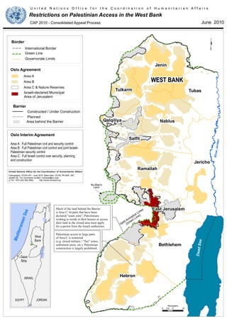
- 1. Hebron Jenin Ramallah Nablus Jericho Tubas Bethlehem Salfit East Jerusalem Tulkarm Qalqiliya 0 5 102.5 Kilometers DeadSea EGYPT JORDAN ISRAEL West Bank Gaza Strip MediterraneanSea $ ¥ No Man's Land WEST BANKWEST BANK RiverJordan Oslo Agreement Area A Area B Area C & Nature Reserves Governorate Limits Green Line International Border Border U n i t e d N a t i o n s O f f i c e f o r t h e C o o r d i n a t i o n o f H u m a n i t a r i a n A f f a i r s Restrictions on Palestinian Access in the West Bank June 2010CAP 2010 - Consolidated Appeal Process Barrier Area behind the Barrier Israeli-declared Municipal Area of Jerusalem Area A : Full Palestinian civil and security control Area B: Full Palestinian civil control and joint Israeli- Palestinian security control Area C: Full Israeli control over security, planning and construction Oslo Interim Agreement Much of the land behind the Barrier is Area C. In parts that have been declared "seam zone", Palestinians wishing to reside in their houses or access their land in the closed area must apply for a permit from the Israeli authorities. 1949 Armistice Lines (Green Line) Palestinian access to large parts of Area C is restricted (e.g. closed military / "fire" zones, settlement areas, etc.). Palestinian construction is largely prohibited. Planned Constructed / Under Construction United Nations Office for the Coordination of Humanitarian Affairs Cartography: OCHA-oPt - June 2019. Base data: OCHA, PA MoP, JRC update 08. For comments contact <ochaopt@un.org> or Tel. +972 (02) 582-9962 http://www.ochaopt.org
- 2. 1 P P P P P P P P P P P P P P P P P P P West Bank Israel Gaza Strip Egypt Jordan JORDANRIVER MediterraneanSea DeadSea Lebanon OccupiedGolanHeights (Syria) Syria UNDOF LAKE TIBERIAS Safe Passage (Non-functional) G U LF O F AQ ABA Tubas Jenin Nablus Hebron Salfit Tulkarm Jericho Ramallah Bethlehem Qalqiliya Jerusalem Acre Eilat Haifa Ashdod Tiberias Nazareth Be'er Sheva Tel Aviv-YaffoTel Aviv-Yaffo Gaza City Khan Yunis P P P P P P P P Rafah Crossing Allenby Bridge Crossing Sheikh Hussein Crossing Sheikh Hussein Crossing o Karak Balqa Amman Irbid Madaba Ajloun Al Qunaytirah ¥ 0 30 6015 Km United Nations Office for the Coordination of Humanitarian Affairs DECEMBER 2011 Occupied palestinian territory International boundary Boundary of former Palestine Mandate 1949Armistice (Green Line) AreaA and B Area C Israeli Unilaterally declared Jerusalem Municipal Boundary Ceasefire line 1974 administered by UNDOF Airport Capital Main City West Bank ~ 848,000 refugees Gaza ~ 1,167,000 refugees Lebanon ~ 455,000 refugees Syria ~ 496,000 refugees Jordan ~ 2 million refugees Paletinian registered refugees* Source:UNRWA,January 2011 Palestinian civilians living in the occupied Palestinian territory (oPt) continue to bear the brunt of ongoing conflict and Israeli occupation. A lack of respect for international humanitarian and human rights law has resulted in a protection crisis with serious and negative humanitarian consequences. In the Gaza Strip, Israel continues to impose a land, sea and air blockade that has significantly undermined livelihoods, seriously diminished the quality of, and access to, basic services, and which amounts to collective punishment of the population of the Gaza Strip. In the West Bank, East Jerusalem is isolated from the rest of the West Bank. Communities in Area C face a range of pressures, including demolitions, settler violence, and movement and access restrictions, that make meeting basic needs increasingly difficult and threaten Palestinian presence in the area. Bedouin and herder communities are particularly vulnerable. Unlawful Israeli settlement activity lies at the heart of many of the humanitarian difficulties facing Palestinians in the West Bank. Overall, the lack of accountability for violations of human rights and humanitarian law,along with a failure to effectively enforce the rule of law when it comes to attacks on Palestinians and their property by Israeli military forces or Israeli settlers, has created a climate of impunity that contributes to further violence. The oPt population is only 38% of the global Palestinian population,projected at 11.2 million people,approximately 44% of which are refugees registered with the UN. Outside the oPt, 1.4 million Palestinians live in Israel, 5 million live in Arab countries and 640,000 in other parts of the world. 4.2 million Palestinians live in the oPt, with 2.5 million in the West Bank and 1.6 million in the Gaza Strip. 38% of the population of the Gaza Strip and 18.3% of the West Bank live in poverty. 28% unemployment rate in the Gaza Strip and 20% in the West Bank 5.8 persons is the average Palestinian household size in the oPt. 33% of the population of the oPt is food insecure. 73 litres/capita/day (l/c/d) is the average water consumption in theWest Bank and 80-90 l/c/d in the Gaza Strip, below theWHO standard of 100 l/c/d. 500,000 Israeli settlers live in 150 settlements and 100 outposts in the West Bank, in contravention of international law. Nearly 44% of the oPt population are refugees and nearly 50% is below the age of 18.* Key Facts on the oPt DISCLAIMER:The designations employed and the presentation of material on this map do not imply the expression of any opinion whatsoever on the part of the Secretariat of the United Nations concerning the legal status of any country, territory, city or area or of its authorities, or concerning the delimitation of its frontiers or boundaries.Reproduction and/or use of this material is only permitted with express reference to “United Nations OCHA oPt” as the source. *Source: PCBS Scan it! with QR reader App