Beginners Guide to TikTok for Search - Rachel Pearson - We are Tilt __ Bright...
Central Waterfront Land Uses1
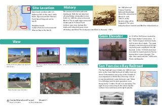
1. Site Location
Islais Creek on the north, U.S.
Highway 280 on the west, India
Basin, Bayview and the Hunters
Point Naval Shipyard on the
south.
Neighborhoods
include Potrero to the west and
Mission Bay to the North.
History
The area used to be marsh and
tidal basin. With the construction
of Long Bridge along what is now
3rd St. in 1865 the area to the west
filled in. The Long Bridge connected
downtown to Hunters Point.
As there was more demand for
docks and industrial space more
of the Bay was filled. The study area was filled in the early 1900’s.
In 1918 Pier 90/92 was created by
the State Harbor Commission. In
the 1920’s the grain terminal had a
mill to serve local needs. The grain
elevators were mostly used for stor-
ing barley and could hold 500,000
bushels. In the 1970’s the terminal
was used to export grains to Russia
during their severe drought. The
silos were used until the 1989 Loma
Prieta earthquake.
Grain Elevator
San Francisco Bay Railroad
The Bay Railroad trace it history to 1889. At one
time as the State Belt Railroad of California it ran
down Embarcadero and as far as the Presidio. It
was important in World War 2 moving 100s of
troop, hospital and cargo trains per year. Today
it is still important for port operation even
though only 5 miles of track is in use today. The
right of way connecting to the Union Pacific/-
Caltrain line could be used for light rail also.
An 1862 photo of
Potrero Point by
Eadward Muybridge
shows the area around
Illinois St. and
19th St. at the
Eastern edge of the
Dogpatch. The area
today has been leveled and filled for industrial uses.
VV
V
View of grain elevator from Illinois and Amador
intersection.
Looking North along Illinois from Amador St.
and Firehouse.
View of Pier 80 container cranes from wetlands
Illinois, Amador, Cargo intersection.
View
V
Central Waterfront Project Sheet# 1
Date: 12/15/2014 by Vanya Suttiruttana
2. T
19
48
ZoningCensus
Change in population
since 2000
Over 20% decline
-10% to -20%
0% to -10%
0% to 10%
10% to 20%
Over 20% increase
Westerly Wind
Trafic Noise
Sun Path
Environmental Factors
The area has prevaling
westerly winds.
Most of the site has
good southern exposure
which provides opportunity
for solar power.
There is background traffic
noise from 280 and 3rd street.
There is also noise from
aggregate operation.
1 mile radius
from 3305 3rd St.
166 vehicle thefts and break-ins
between 10/20/2013-10/20/2014
The area is not developed yet so the crime
rate is low compared to the areas around it.
These vehicle crime statistics show the need
for secured parking.
Crime Type Summary
Crime Types by Day Of Week
71
Motor Vehicle Theft (95)
Vehicle Break-In/Theft (71)
Auto Theft
Central Waterfront Project Sheet# 2
Date: 12/15/2014 by Vanya Suttiruttana
3. Circulation
T
T
T
T
T
T
T
T
48
48
48
T22
22
22
19
44
Van Ness and Sunnydale
Fisherman’s Wharf and Hunters Point
Richmond and Hunters Point
Parks & Openspace
The blue greenway project
is the improvement of the
southern portion of the Bay
Trail. This section runs along
the bay however our
section does not because of
the working port. Since it
will be converted to PDR
and residential there is an
opportunity to connect the
Pier 94 Wetland to the Bay
Restaurants
Night Life
Shopping
Actives Life Art & Entertainment
Beauty & Spa
Groceries
Cafe
AmenitiesPublic Services
Fire Stations
Schools
Postal Offices
Librarys
Fire station #24 located on 3rd St. and
postal service located on Burke Ave are
close to the site.
The closest elementary school Malcolm
X Elementary and Anna E. Waden
library are in Bayview district. Both
library and the school are about 1 mile
away.
Central Waterfront Project Sheet# 3
Date: 12/15/2014 by Vanya Suttiruttana
4. Goals Concept 1 Concept 2 Concept 3
Create housing for people with wide range of incomes to address the housing
needs.
9 10 8
Preserve the historic elements, characteristic and diversity of the
neighborhood.
9 9 9
Develop and enhance public linkages within neighborhood commercial districts
and to other nearby area.
10 10 10
Create network of green streets with bicycling infrastructure that connects
parks, neighborhoods, commercials and public transits.
9 9 8
Maximize off street parking with minimal visual impact and improved security. 9 10 9
Promote local, neighborhood serving businesses and micro enterprises by
provide amenities that would serve residential and worker’s needs (school,
restaurants, shopping and entertainments).
10 9 8
Encourage residents, workers, and visitors to use public transportation by
expanding infrastructure for easy Transit station access and creating a safe
pedestrian friendly environment.
10 10 10
Create an urban community with easy access to the waterfront, open spaces
and parks.
9 10 8
Promote maritime activities on the central waterfront 8 10 10
Design for sea level rise with minimal damage from flooding 10 10 10
Total 93 97 90
A Place to Live A Place to Work A Place to PlayConcept 1
Concept 2 Concept 3
Central Waterfront Project Sheet# 4
Date: 12/15/2014 by Vanya Suttiruttana
6. Bicycle System Primary Street Section
Secondary Streets Section
Bicycle access is provided for all road ways in the development area. Mostly
this is by dedicated bike lanes and a bike route. Bike infrastructure connects
to the existing bike lanes on Illinois and Cargo. Cargo provides access to 3rd
Street where a bike route continues. Bike lanes access all the office develop-
ments and connect to light rail and the ferry terminal for easy commuter
access to mass transit.
To the right are street sections for the primary and secondary streets. The pri-
mary streets encompass the boundary road which encircles the site and the
south access road. An example layout for the four lane roads is shown in sec-
tion A:1. The south access road has on street parking as a buffer and a bike
lane adjacent to the traffic lane as shown in section A:2. The secondary
streets are for local traffic therefore there is only one traffic lane in each di-
rection. An example layout is shown in section A:3. `
Section A:1-6
Section A:2-6
Section A:3-6
Bike Lane
Bike Route
Existing BikeLane
6’ 5’ 6’ 6’5’
5’5’5’5’ 5’ 5’ 5’ 5’5’ 5’
5’ 5’5’ 5’5’
11’ 11’
11’
11’ 11’12’
11’ 11’
11’ 8’5’12’
6’
IllinoisSt
Cargo St
3rdSt
Scale 1”= 300’
Scale 1/8”= 1’
8’
Central Waterfront Project Sheet# 6
Date: 12/15/2014 by Vanya Suttiruttana
7. Phase I
Phase II
Phase I of the development includes the northern section
of the site. Work in this phase includes transportation infra-
structure of the light rail and the ferry terminal to support
the commuter transit needs of both phase I and II. Both
hotels and an adjacent large office and retail mixed-use
building are completed. Housing in this phase includes
most of the high density units and the live-work building.
Additionally the museum, entertainment and main retail
complexes will create an active community environment.
The entertainment center will provide both office workers
and local residents nearby dining opportunities. Lastly, the
grocery store and school provide needed support for the
residential development. The open space bordering the
canal on the northern boundary and the open space along
the bay front will be done.
Phase II build out includes most of the R&D, Office and residen-
tial. The residential includes both the remaining high-density as
well as most of the low-density units. The community center and
green space will be completed in this phase as well. The open
space on the southern boundary will be completed as a buffer to
eventual development. This phase will also add some additional
community oriented retail. This phase benefits greatly from the
transportation, retail and entertainment development during
phase I. Having the transportation completed in phase I should
make finding tenants for the large amount of office space in this
phase easier.
Central Waterfront Project Sheet# 7
Date: 12/15/2014 by Vanya Suttiruttana