
Recommandé
Contenu connexe
Tendances
Tendances (20)
En vedette
Similaire à What i talk about when i talk about landscape
Similaire à What i talk about when i talk about landscape (20)
Plus de Amir Mueller
Dernier
Dernier (20)
What i talk about when i talk about landscape
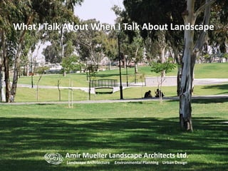
- 1. Amir Mueller Landscape Architects Ltd. Landscape Architecture Environmental Planning Urban Design What I Talk About When I Talk About Landscape
- 2. “The concept of “another”, man-made nature, thus seems a fusion of two elements: the design inherent in nature and the improvements of nature which are interpreted as the effects brought about by human art in fulfillment of the design. ” John Rennie Short: Imagined Country: Society, Culture and Environment 1991. “The wilderness is ... at one extreme, the place of God’s creation; … on the other, a place whose transformation by human actions allows the possibilities of redemption.” Clarence J. Glacken: “Changing Ideas of the Habitable World” Man’s Role in Changing the Face of the Earth. 1956 Garrett Hardin: “The Tragedy of the commons”. Science 1968 “A technical solution may be defined as one that requires a change only in the techniques of the natural sciences, demanding little or no change in human values or ideas of morality.”
- 7. William E. Odum: “Environmental Degradation and the Tyranny of Small Decisions” BioScience 1982 . “Much of the current confusion and distress surrounding environmental issues can be traced to decisions that were never consciously made, but simply resulted from a series of small decisions..” Simon Schama: Landscape and Memory 1995. “… a way of looking; of rediscovering what we have, but which somehow eludes our recognition and our appreciation. Instead of being yet another explanation of what we have lost, it is an explanation of what we may yet find” William Haddon Jr.: “On the Escape of Tigres, an Ecologic Note” American Journal of Public Health 1970 “(some people view) harmful interactions between man and his environment as problems requiring reforming imperfect man rather than suitably modifying his environment.”
- 8. Henry Louis Mancken “For every complex problem, there is a solution that is simple, neat and wrong”. Robert J. Bennett. “Administrative Systems and Economic Spaces”. Journal of Regional Studies 1997 “… increased emphasis on environmental responses and sustainability at a local level, create a major need to manage spillovers and environmental interactions across several different administrative units.” Gillian Rose. Feminism and Geography: The limits of geographical Knowledge. 1993 “ . . . Spatial structure was seen not merely as an arena in which social life unfolds but as a medium through which social life is produced and reproduced.”
- 17. There is urgency in mitigating between cultural and technological advancement and serving the need for an undefiled environment. Therefore, incorporating environmental, social, and economic responsibility into the design process is vital to viable landscape architecture design. Our designs reflect the belief that successful landscape architecture is founded on the understanding of the ways in which people interact with the environment. We work at the interface between culture and environment in order to create durable and expansive landscapes. We specialize in integrating ecological thinking and understanding of natural processes into the design process. Considerable effort is put to understand the ways in which people interact with the environment. That understanding is then used as the main input for the design work.
- 28. Landscape Restoration of the Northern Gas line 2009
- 58. Verizland Garden – Herzeliya 2008 First Prize – Design Competition 2002
- 59. Design Diagram
- 62. Design Objectives • Restoring the garden for public use • Preserving the garden’s character • Creating a contemporary Garden for Changing uses • Allow for multiple uses and age groups Preliminary Landscape Plan
- 63. Garden Structure Built Elements Existing Trees Spaces Paths Removed Trees New Planting
- 64. Old Design New Design
- 71. Industrial Park – Nazareth 2013
- 85. Urban Plaza - Rehovot 2013
- 99. Positivistic Analysis for Progressive Landscape Planning: A Methodology for Generating Socially-Based Future Alternatives Landscape planning Studio – 2006-2008 Faculty Of Architecture and Town Planning Technion – Israel Institute of Technology
- 100. Most landscapes exist at the interface between the social pressure for conservation and the demand for development due to economic growth. The landscape we experience is a product of planning and decision making that shape it over time. Therefore, separating human from natural influences is arbitrary. The Spatial Dilemma focuses on identifying key processes in the region that can form the base for planning. While the spatial distribution of land uses shapes the landscape and influences the way in which we experience it, decisions about which areas to conserve and which areas to develop are the most important process in landscape planning.
- 101. Prevalent Approaches All of these solutions result in short term plans that focus on minor issues that are in agreement Most contemporary landscape planning is aimed at balancing conflicting regional interests in order to foster development based on the specific needs of communities in the region. Planers, who are consumed by the demand to identify needs and wants in the region, are expected to develop a plan that is sensitive to social process. Data based planning separates the community from the solution. Community based planning provides social sensitivity and increases community awareness to its needs.
- 102. Planning for Objectivity It is important to generate objective and viable future alternatives in order to foster region specific development while conserving valuable – both natural and cultural – resources. Regional future alternatives require some basic spatial statistic and physical data which can be found at most planning agencies and can easily be converted to GIS. Other socio-economic knowledge about the region can be gleaned from round-table discussions with major stake holders. Plan objectives should be formulated as a response to regional indicators that reflect failure in the way in which a region functions. Progressive Landscape Planning responds to planning and market failure and leads to the development of socially-based alternatives
- 103. Process Models Evaluation Models Sensitivity Models DataObjectivesBoundary N=50N Future Alternatives Alternative Evaluation Alternative Formulation Choosing Alternative Converging Selection N=10 Methodology Structure Input Process Output
- 104. Focuses strictly on regional issues to formulate future alternatives that are region specific Existing Condition Analysis: Positivistic analysis of the study area Define the environmental and socio-economic principles by which the region functions Defining the Plan’s Objectives: Establishes a regional ethic Defines the ethic roles under which the regional strategy is formulated. Boundary Definition: Describes a specific area with a specific solution Defines the regional principles under which future alternatives are developed Progressive Planning
- 105. Progressive Planning Analyze the relationship and the degree in which regional issues overlap with municipal, district, and other administrative boundaries Boundaries serve to define unique and site specific solutions to universal issues By comparing the degree in which the plan’s objectives are achieved, it is possible to compare future alternatives with different boundaries. This leads to spatially different but core-issue similar future alternatives that are site specific Evaluation Analysis – Strengthening existing towns
- 106. At the landscape plan, boundaries have a cardinal impact on the scale and scope of different future alternatives. Statutory boundaries are formulated due to administrative decisions that do not adequately represent regional processes. Planning areas are commonly defined by administrative decisions that do not reflect statutory boundaries. The study area is defined by existing condition analysis (as defined in the spatial dilemma above) and represents regional processes well. Future alternatives, therefore, are defined by their specific boundaries and represent regional solutions. Bennett 1996 Variability in Regional Definition The following slides illustrate the process of Progressive Landscape Planning for generating of socially-based future alternatives
- 107. Tel Aviv Metropolitan Area: Existing conditions Landscape Planning Studio 2007 Land-use
- 108. Existing Conditions Analysis Emphasis on Open Space and Development Pressure • Urban Sprawl and lack of community identity • Increased pressure on remaining open space • Open space is not available to the public. Construction and Open Space Problem: Vulnerable to development Transportation & Employment Problem: Spatial inequality in employment opportunities Socio-Economic Level Problem: Strong centers vs. week periphery • Tel Aviv as main employment center • Increased commuting into Tel Aviv • Lack in public transportation service • High variability in Socio- economic level among entities in the region
- 109. Density – Western edge of region is densely built. Need to increase density and strengthen population along eastern edge Employment – Due to the high concentration of business in Tel Aviv there is Untapped potential for economic development at eastern edge Open Space - Develop open space for sports and recreation based on location and accessibility Accessibility – improve accessibility within plan boundary to improve access to different centers Existing Conditions Analysis Emphasis on Transportation and accessibility
- 110. • Understanding the region’s importance at the national level • Distinguish between core and periphery • Relationship to Tel Aviv metropolitan Area Alternative I – acceptance of most national master plans with locally specific solutions Alternative II – reaction to existing national and regional master plans. Increased development as a means of controlling the allocation of resources Alternative Futures
- 111. Alternative III – centralization with hyper- accessibility Alternative II – decentralization with local solutions Alternative I – local adaptation with affiliation to the metropolitan center Hierarchy of systems (Solutions for accessibility and transportation) • Regional super structures, regional transportation • Regional systems of infrastructure, transportation and open space • Local systems of public open spaces and public services Alternative Futures
- 112. Planning within a set of fixed objectives and programmatic constraints limits local development The spatial difference between alternatives reflects local needs and emphasis Spatial variability emphasizes divergence of solutions Core areas provide a spatial anchor that adequately represent spatial issues Despite common core areas, variability stems form the difference in boundary definition Future alternatives arise from a highly localized methodology as an integral part of the planning process Take-Aways Sensitivity Analysis – Attracting new populations to the region while empowering existing communities
- 113. Most landscape plans are implemented over time. Therefore, there is a large degree of uncertainty at the time they are conceived. By providing localized and socially relevant solutions, Progressive Planning minimizes uncertainty while maximizes flexibility. This methodology is scalable and can be applied to small scale, limited scope projects as well as to large landscape plans. Sensitivity Model Evaluation Model Summary
- 114. Amir Mueller Landscape Architects Ltd. Landscape Architecture Environmental Planning Urban Design What I Talk About When I Talk About Landscape
Notes de l'éditeur
- I want to start my talk with a short discussion about landscape architecture. In particular the way I see our role as shapers of the environment. I believe that the biggest challenge facing landscape architects today is providing design and planning solutions to both old and new problems. This in turn should lead to creating a rich and varied environment that is not a construct of design whim and ideology, but rather a reaction to the true needs of the community and the environment.
- This, I believe should stem from the way we view the world around us, how we formulate our ideas about the world, thoughts that inspire us, things that provoke us, and ideas that make us examine our own knowledge.
- The problems we face are ubiquitous. Traffic jams for example occur everywhere from Los Angeles,
- to Tel Aviv
- Nairobi, other issues include urban sprawl, water and air pollution and a myriad of other problems.
- We all live in cities thatmore often than not look like this (6.1), with severe episodes of air and water pollution (6.2) (Los Angeles River, Yarkon River Tel Aviv, and Ngong River Nairobi), but we all strive to live in cities that look like this (6.3) clean, comfortable and modern.
- These problems are neither new nor cultural specific and include issues of gender, governess, resource management and space. So, what does all this have to do with landscape architecture?
- I believe that it is our role as professionals to improve the places in which we live in by looking first at what is out there and find new solutions to old problems.
- Old problems include issues of public open space, transportation and flood control. Solutions that were appropriate 30 years ago begin to break down due to increased pressure by a growing population and rise in the standard of living.
- New solutions (at may be problems by themselves) include ways in which the available public space is used to include alternative modes of transportation making our cities more user-friendly. (For example bike sharing. More than18 thousand people commute to work on bikes on a daily basis in Tel Aviv and the number of users has increased by 15% per year since 2008. National and City wide plans help encourage the use of bikes for daily commuting and bike lanes are a part of every new project.) The implementation of new solutions includes alternative modes of transportation often mixing incompatible uses mixing bikes with cars. This in turn creates impossible situations that make urban life extremely chaotic.
- These solutions often mix incompatible uses such as pedestrians with bikes or mixing bikes with cars.
- This in turn creates impossible situations that make urban life extremely chaotic.
- It also leads to the blurring of the traditional boundary between uses that has recently become the arena where people voice their grievances against the government (in Israel in 2011, but also in the USA with the occupy Wall Street movement in 2012).
- These are the primary places where people voiced their grievances against the government during the social protest movement that swept Israel in 2011.
- Occupying public spaces and blocking major thoroughfares has immediate impact on daily activities which forces the government to act swiftly in most cases. In israel this lead to social and tax reform.
- There is, however, also a positive side to the blurring of the traditional boundaries between different land-uses. These spaces also become places for recreation and sport’s activities such as mass sports and cultural events. In Tel Aviv there are at least four major events: the Nike 10k Night Run, the Tel Aviv Marathon, the Round Tel Aviv Annual Bike Tour, and the annual Gay Pride Parade. These events attract tens of thousands of people and became hallmarks of the city attracting participants from around the world.
- Understanding all this helps us create our own unique world view that is constantly evolving to face new challenges; yet, it is apparent in any aspect of our work. It serves as the ideological foundation of our work and can be traced from one project to the next. So how do we do it in my office?
- Let me begin by saying that landscape architecture design is a collaborative multi-disciplinary process. It requires collaboration both in-house and across disciplines. So even though we are a small firm, we are involved with large and complex projects. Most of our work is in the public realm where budget, efficiency, social needs and wants as well as the need for caring for the environmental shape the way in which we approach our projects.
- We work throughout Israel and overseas at different scales, climates, social and environmental conditions.
- Bell garden Beer Sheva in an arid climate where flash floods are common. 4.3 Hecters
- In contrast this is a small neighborhood garden inHerzelia on the coastal plane. 3,500 sq. m.
- A 1200 dwelling unit subdivision where the site plan is based on providing solutions for surface runoff and recharge of ground water.
- A 2100 dwelling unit subdivision in Netanya, along the coastal plane at the edge of the city where the site plan is based a planting scheme that encourages the development of habitat within the urban environment.
- A 15000 sq. m. youth center in Netanya
- A high-school yard in Herzeliya
- A birding site on the eastern shores of the Sea of Galilee
- Our proposal for the reclamation of Israel’s largest landfill.Of all the work we have done over the past few years I will be showing four different projects that represent different aspects of our portfolio and the way we deal with the challenges they present. And one project in landscape planning conducted as a design studio at the Technion where I teach Landscape Architecture.
- Linear infrastructure projects have great impact on the landscape simply because they extend over great distances and construction operations severely impact the landscape.
- The northern Natural Gas Pipe Line is 60 kilometers long and passes through different landscapes, forests
- agricultural land
- and natural habitat.
- And while it is important for economic development, construction of linear infrastructure is extremely destructive to the landscape
- So, how do you deal with it?
- First we conducted a comprehensive landscape survey to create a baseline against which restoration will be measured.We literally walked the whole length of the project several time until we had a good understanding of the landscape.
- We than divided the project into restoration unites with specific instructions for each section point along the line.
- As well as composing written guidelines that describe the area and nature of the work to be done before, during and after construction.
- The guidelines were accompanied with a series of plans and maps detailing what work should be done at each location
- And detailed drawing describing specific conditions for the construction phase and restoration phase.
- And this is what it look like!
- The next project is a design competition for the restoration and rehabilitation of a 1.8 hectare neighborhood park in the City of Herzeliya for which we have won the first Prize.
- So how do you approach such a project where all you have is a brief provided by the city? We started by analyzing the existing garden, its layout, the relationship between spaces and the overall compatibility of the park to contemporary uses
- This lead to the conceptual landscape plan that lays out a way for rehabilitating the garden, adapting it to contemporary uses, while at the same time keeping its original sense of human scale.
- Analyzing different layer of the existing garden helped us identify which areas should be developed and in which way and formed the base line for understanding the garden’s development.
- Once the concept was laid out we described the design objectives and developed a preliminary landscape plan that formed the base for construction documents.
- This was done at the same layers as the analysis so we were sure that our design stays on tract and in sync with the design objectives
- The difference between the two plans is apparent yet the character of the garden remains the same mainly since a conscious decision was made to protect the majority of the existing trees on site.
- And this is what it look like.
- The challenge in designing the Nazareth Industrial Park was creating a contemporary landscape that is deeply rooted in the historic setting of the old city of Nazareth with its holy places and unique character while at the same time creating a contemporary setting for a High Tech industrial park.
- The 1.8 hectare site is located on top of a hill at the southern outskirts of the city of Nazareth. In 2011 the site was converted to an enormous helipad in honor of Pope Benedict the 16th who gave a sermon for nearly 100 thousand people on mount Precipice that flanks the site on the east.
- And this is what it looks like..
- We find that urban plazas tend to be the most challenging of all projects regardless of scale. This is because they tend to incorporate into them multiple uses that are more often than not incompatible.
- That is because they tend to be the places where conflicting uses collide and activities interact.
- So in this case the first order of business was to identify obstacles that hinder access from the street.
- And identify potentials for interaction between uses.
- Another challenge is to allow business to continue operating during construction and make sure it is done in a timely fashion.
- And some work is extremely complicated and requires special care and expertise.
- And there is a time in every project, I call it the concrete phase, where you get the feeling that you got it all wrong and that the project is a total failure.
- But once its complete, and people begin to use the space, some time in unexpected ways, you know that your instincts were right. This is a sign announcing an arts fair every Monday and Wednesday between 5 to 10pm.
- And his is what it looks like!
- Finally I want to talk about a series of Landscape Planning Studios I taught at the Technion’s department of Landscape Architecture with my colleague Amir Hefets between 2006 and 2008.
- While small and medium scale problems can be solved using both design based methods as well as planning based methods, large scale problems, covering an area of several square kilometers, can only be solved using a prescribed methodology that is designed to guide the process and produce mutually exclusive objective Future alternatives.
- There are several Contemporary approaches to Landscape Planning which are implemented in different regional plans each with its own shortcomings.
- Therefore,the most important challenge in Landscape Planning is planning for objectivity. That is creating Future Alternative that focus on socio-economic issues which are region specific.
- The main advantage of this methodology is that it requires some basic data that can be easily found in most public records and develops solutions that correspond to local needs and wants.
- This method ensures a tight connection between site specific existing conditions analysis, plan objectives, boundary definition and developing regional specific Future Alternatives.
- Thank you very much. I will be happy to answer some questions.