Geophysics, geotechnisc and topographics exploration
•Télécharger en tant que PPT, PDF•
2 j'aime•811 vues

The geological structure and the pshysical-mechanical characteristics of the underground play an important role in designing buildings. Using direct methods such as open digging, drilling, sampling for laboratory tests, etc. and indirect geophysical methods, these characteristics can be determined with high precision. This method helps in making resistance and econom

Recommandé
Recommandé
Contenu connexe
Tendances
Tendances (18)
Similaire à Geophysics, geotechnisc and topographics exploration
Similaire à Geophysics, geotechnisc and topographics exploration (20)
Dernier
Dernier (20)
Geophysics, geotechnisc and topographics exploration
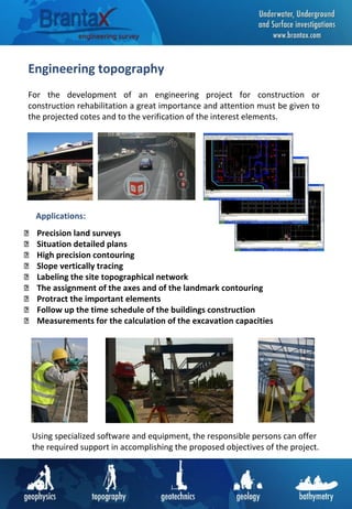
- 1. Engineering topography For the development of an engineering project for construction or construction rehabilitation a great importance and attention must be given to the projected cotes and to the verification of the interest elements. Precision land surveys Situation detailed plans High precision contouring Slope vertically tracing Labeling the site topographical network The assignment of the axes and of the landmark contouring Protract the important elements Follow up the time schedule of the buildings construction Measurements for the calculation of the excavation capacities Using specialized software and equipment, the responsible persons can offer the required support in accomplishing the proposed objectives of the project. Applications:
- 2. Bathymetrical investigations The bathymetry can be taken for the aquatic equivalent of altimetry. Being a branch of hydrometrics, the bathymetry is dealing with the measurements of the sea depth, lakes and river depth, allowing us to draw maps of their aquatic relief. Descending the depth measurements technique with the help of the sonar and the exact position given by the GPS technology, we can draft for you depth maps or base relief structure maps for lakes or rivers, and also bathymetric profiles on the interest zones. This type of measurements has a large applicability in various fields and can contribute to a good acknowledgement of the geo-morphological conditions: Tracking down the cloging of rivers and lakes Tracking down the excavation from the ballast-holes Exploration of the mineral aggregates from the river Drawing the maps for flooding risks Bathymetric sections and maps Hydrological studies Applications:
- 3. Geoelectrical investigations The geoelectrical investigation is one of the main methods of geophysics with the help of which we can determinate the geological, hydrological and technological characteristics of the underground. Geological characteristics determinations Map drawing of the contamination spots Infiltrations in dams and dikes Identifying of the non-homogeneities Galleries and underground cavities Groundwater exploration Identifying the fissures and drifts Buried pipes Geological sections By adapting a device, the method can be applied also on rivers or lakes, which allows us to find out their base structure, where the regular methods are not able or they are difficult to be applied. The multi-electrode method allows us to scan the field both in 2D and in 3D the last one being ideal for the investigation of extended surfaces. Applications: This method allows an investigation depth which varies from 10-30 m for the engineering projects and it can go until 300 m for the geological and hydrological researches.
- 4. Magnetical and electromagnetical investigations More than often, the locations of the future buildings are full of underground networks of pipes, sewages or electrical wires. In order to avoid future problems in the execution of the works and very useful in the design phase of the project we must take into consideration the possible existence of those networks. With the help of magnetical measurements we are able to identify all kind of metallic objects buried in the underground. •Electrical buried networks •Construction foundations •Concrete pipes •Unexploded bombs •Metallic pipes •Buried docks This kind of investigations can be made both on soil and lakes or rivers. The method is most applicable on the vacant lands, un-affected by the industrial environment, having a high profitableness. Applications:
- 5. Georadar investigations GRP (Ground Penetrating Radar) is an electromagnetic method non- destructive which has a large practicability in the industrial environments where the surface is covered with concrete. The investigation depth depends on the geological environment where the research is located, and for the engineering projects this depth is of 6-8 m. • The analysis and the identification of the tunnels • Geological and hydrological explorations • Identifying the buried pipes • Map drawing of the contamination spots • Identifying the electrical buried cables • Identifying the underground cavities • Archeological researches In particular situations, depending on the working conditions, we can obtain 3D images with the interest zone allowing us to see in detail the underground conditions. Applications:
- 6. Seismic refraction and MASW Seismic refraction is a useful method for investigating geological structure and rock properties. The technique involves the observation of a seismic signal that has been refracted between layers of contrasting seismic velocity. • Stratigraphic mapping • Estimation of depth to bedrock • Estimation of depth to water table • Predicting the rippability of specific rock ypes • Locating sinkholes • Landfill investigations • Geotechnical investigations Applications: Multichannel analysis surface waves (MASW) tests determine the speed profile of Vs shear waves, therefore: •Seismic actions for designing and verifying Civil Engineering works •The soil seismic type (A, B, C, D, E, S1, S2) •The soil rigidity module •Sinking and displacement of works that interact with the soil: buildings, bridges, embankment rises, supporting works, etc..
- 7. Hydrotechnical projects The geophysical surveys use non-destructive methods to allow extensive investigations of various hydro technical projects: - Land, rock or concrete dams - Protection dykes - Functional dykes Geoelectrical – Using the Vertical Electrical Survey (SEV), Electrical Tomography or Mise-a-la-masse, this method has proven most efficient for locating areas of water infiltrations and for scanning the density of the built-in material from the dykes or dams. Georadar (GPR) – It has a very high resolution and accuracy for areas made of concrete, locating holes and anomalies in the density of the material below. Seismical – This profiling method can accurately show data about the homogeneity of the built-in material from dams or dykes. Methods used:
- 8. Das Verfahren Die elektrischen Eigenschaften des Baugrundes werden über ein künstlich an der Erd- oder Wasseroberfläche erzeugtes elektri- sches Feld, das dem Untergrund über Stromelektroden zugeführt wird, erfaßt. Mittels Meßelektroden wird die sich einstellende Po- tentialdifferenz gemessen und hieraus der scheinbare spezifische elektrische Widerstand berechnet. Zur Ermittlung der Tiefenlage einzelner geologischer Schichten sind eine Reihe von Einzelmes- sungen erforderlich. Hierzu wird der Stromelektroden-Potential- elektroden-Abstand unter Beibehaltung des Auslagenmittelpunk- tes schrittweise so weit vergrößert, bis die gewünschte Informa- tionstiefe erreicht ist. Auf diese Weise wird der scheinbare spezifische elektrische Wi- derstand als Funktion der Elektroden-Abstände und somit als Funktion der Tiefe für den jeweils auf dem Profil festgelegten Meßpunkt ermittelt. Die computerunterstützte Auswertung ergibt schließlich die An- zahl der Schichten, ihre Mächtigkeiten bzw. Tiefenlagen sowie die einzelnen spezifischen elektrischen Schichtwiderstände. M u t t e r b o d e n , s t a r k s a n d i g F e i n s a n d m i t T o n a n s c h l ä m m u n g M i t t e l s a n d , k i e s i g , s t e i n i g K i e s - S a n d K i e s - S a n d , s t e i n i g A u f f ü l l u n g F e i n s a n d T o n u n d F e i n s a n d , t o n i g a ) S c h o t t e r b ) S c h o t t e r m i t S t e i n e n F l u v i o g l a z i a l e S e d i m e n t e G l a z i a l e S e d i m e n t e a) b) G e o e l e k t r i s c h e W i d e r s t a n d s t i e f e n s o n d i e r u n g P r o j e k t i e r t e B o h r a c h s e T o n , f e s t S c h l u f f t o n a ) S c h l u f f t o n ( f e s t ) m i t S t e i n e n b ) S c h l u f f t o n ( f e s t ) m i t e r h ö h t e m S t e i n a n t e i l b)a) W a s s e r S S W N N E 255 250 245 240 235 230 225 220 215 210 205 200 195 190 185 180 175 170 165 160 155 150 145 140 135 130 125 120 115 110 105 100 95 90 85 80 75 70 65 60 55 50 45 40 35 30 25 20 15 10 5 0 5 E n t f e r n u n g z u m A u s t r i t t s p u n k t ( m ) 255 250 245 240 235 230 225 220 215 210 205 200 195 190 185 180 175 170 165 160 155 150 145 140 135 130 125 120 115 110 105 100 95 90 85 80 75 70 65 60 55 50 45 40 35 30 25 20 15 10 5 0 5 - 1 5 - 1 0 - 5 0 5 1 0 1 5 Höhe(m) - 1 5 - 1 0 - 5 0 5 1 0 1 5 B 9 B 8 Die Idee Für eine optimale Planung und Durchführung einer Dükerbau- maßnahme ist es erforderlich, möglichst detaillierte Kenntnisse über den Untergrundaufbau im Verlauf der Trasse zu besitzen. Die üblichen Vorerkundungsmethoden unter Einsatz von Ramm- kernsondierungen, Kernbohrungen etc. lassen eine „lückenlose“ Untergrundbewertung im Bereich von Gewässerquerungen, ins- besondere unter Kostengesichtspunkten, nicht zu. Hier bieten sich die klassischen geoelektrischen Verfahren, die bei der La- gerstättenerkundung seit langem routinemäßig eingesetzt wer- den, für die Untersuchung der geplanten Trasse an. Das Ziel der geoelektrischen Verfahren (z.B. Widerstandstiefen- sondierungen) ist die Ermittlung der Verteilung des spezifischen elektrischen Widerstandes im Untergrund. Sie stellt die Grund- lage für die Bestimmung der Mächtigkeit bzw. Tiefenlage einzel- ner geologischer Schichten im Verlauf der geplanten Verlege- trasse dar. Mit den entsprechenden lokalen geologischen Kennt- nissen z.B. aus Bohrungen kann daraus ein geologischer Verti- kalschnitt modelliert werden. 0 2 4 6 8 1 0 1 2 m M N4 3 2 1 M N BA A B A B / 2 1 2 3 4 5 6 2 3 4 5 7 1 0 1 2 m m Tiefe(linearerMaßstab) AB/2(logarithmischerMaßstab) 2 0 5 0 1 0 0 O h m * m S p e z . e lk t r . W i d e r s t a n d ( lo g a r i t h m is c h e r M a ß s t a b ) 1 2 3 4 E r d o b e r f l ä c h e 1 0 0 O h m * m 2 0 O h m * m S t r o m l i n i e n v e r t e i l u n g i m Z w e i s c h i c h t f a l l G r a p h i s c h e D a r s t e l l u n g d e r S o n d i e r u n g s k u r v e G e m e s s e n e r s c h e i n b . s p e z . e l e k t r . W i d e r s t a n d S p e z i f i s c h e r e l e k t r . W i d e r s t a n d m Am V Rivers and lakes under-crossing We use specific geophysical and geotechnical methods to obtain results which substantially improve the knowledge about the itinerary of rivers and lakes under- crossings. Geoelectrical – using Vertical Electrical Survey (SEV) or Electrical Tomography, this method has proven most efficient over time due to its high precision rate. Magnetic Gradient – it can be used when we need to locate the metallic items on the itinerary of the under-crossing. Georadar (GPR) – this method has a high resolution and can be used in case of shallow waters 1-3 meters deep Land measurements – it delivers maps and topographic profiles needed in drawing- up the future works. Batimetry – this investigates the water depth, complementing the information from the surface land measurements. Methods used:
- 9. Infrastructure projects As a result of our extensive experience in Romania and abroad, we developed a complex package of services dedicated to the infrastructure projects development: all types of roads, water works, major pipes, river under-crossing. Topographic measurements: •Vectorization maps and plans •3D modeling for large areas •GPS measurements •Situation plans •Longitudinal and transverse sections •Stakeout and verticalization •Accuracy levelling Geotechnical studies: •Geotechnical drilling •Dynamic penetration tests •Plate test •Sampling •Laboratory tests •Documentation Geophysical investigations: •Vertical Electrical Sounding (VES) •Geoelectrical profiles •Geoelectrical maps •Magnetic measurements •Electromagnetic measurements
- 10. Mapping buried utilities and other items We use dedicated geophysical methods to scan extensive areas in order to locate underground items: •Water utilities– concrete, metal or PVC •Electricity lines– medium and high voltage •Buried pipes – water, gas, petroleum products, etc •Unexploded buried bombs ( UXO) The depth of investigation varies from 1 to 6 meters and it depends on the area under survey and on the size of the utilities in question. The methods are non-destructive and highly accurate. Methods used for locating under ground utilities: Georadar (GPR) – it is highly efficient for industrial areas covered in concrete Magnetic Gradient – this method is efficient for locating utilities buried under large agriculture fields Electromagnetic – this is complementing the information for the industrial areas, for metallic pipes and electricity lines. We can make such investigations on land or on rivers and lakes.
- 11. Photovoltaic parks We can help you put the basis of a photovoltaic park by acquiring all the needed information about the characteristics of the project area. We perform measurements and surveys which allow a safer and more efficient development of such projects in any given location. Topographical surveys: •3D modeling for large areas •GPS measurements •Situation plans •Stakeout and marking •Finally drawing Geotechnical studies: •Geotechnical drilling •Dynamic penetration tests •Plate test •Sampling •Laboratory tests •Documentation Geophysical investigations: •UXO investigations •Mapping underground utilities •Electrical Resistivity Imaging •Seismic Refraction and MASW
- 12. Wind power parks The different stages of a wind power park project require various studies and surveys: land measurements, geotechnical studies, geophysical surveys. We have extensive experience in performing all these services and we can offer you the best prices on the market. Topographic measurements: •3D modeling large areas •GPS measurements •Longitudinal and transverse sections •Situation plans •Stakeout roads and ditches •Stakeout and plumb poles Geotechnical studies: •Geotechnical drilling •Dynamic penetration tests •Plate test •Sampling •Laboratory tests •Documentation Geophysical investigations: •Seismic Refraction •Seismic Surface Wave •Electrical Resistivity Imaging •Vertical Electrical Sounding (VES)
- 13. Aerial photography Aerial photography provides useful insights into the development of projects from the design stage, going to execution, inspection and maintenance. Using drones (UAV) to capture aerial imagery brings extra flexibility in works approach with much lower costs compared to conventional aircraft. Aerial photography application: • Orthophotomap and photogrammetry • 3D terrain model • Oblique and panoramic images • Electrical Network Monitoring •Agricultural and forestry inspection •Multispectral photos • Infrared thermal photos • Industrial and residential buildings • Wind farms and photovoltaic •Construction and infrastructure monitoring •Monitoring excavation pits •Volume calculation of excavated material deposits •Archaeological photos •Communication pathways mapping
- 14. Geotechnical studies Represent the first stage of the construction or strengthening of a target. This kind of investigation gives information about soil structure and consistence, groundwater level and provide recommendations for the technical project. Geotechnical services: •Geotechnical drillings •Dynamic penetration tests •Foundation uncover •Plate tests •Sampling •Laboratory tests •Hidrogeological studies •Elaboration of the documentation The geological structure and the physical-mechanical characteristics of the ground play an important role in designing buildings. Using direct methods (open digging, drilling, sampling for laboratory tests etc.), and indirect methods (geophysical methods), determination of these characteristics is done with high precision. This method helps to perform resistance and economical calculation.