PJ Seksyen 3 Cognitive Mapping
•Download as DOCX, PDF•
1 like•167 views

Seksyen 3 in Petaling Jaya, Malaysia is analyzed using Kevin Lynch's cognitive mapping framework. The area contains distinct districts like residential, commercial, religious and educational. Major roads form strong edges around the triangular shaped area. Prominent landmarks like mosques and tall buildings aid navigation. Key paths connect districts and landmarks, with wider primary routes and narrower secondary streets. Intersections between paths serve as important nodes gathering people. Analyzing the area's paths, edges, districts, nodes and landmarks provides insights for improving urban design and navigation.

Recommended
More Related Content
What's hot
What's hot (20)
Viewers also liked
Viewers also liked (20)
Similar to PJ Seksyen 3 Cognitive Mapping
Similar to PJ Seksyen 3 Cognitive Mapping (20)
More from Anthony Chew
More from Anthony Chew (20)
Recently uploaded
Recently uploaded (10)
PJ Seksyen 3 Cognitive Mapping
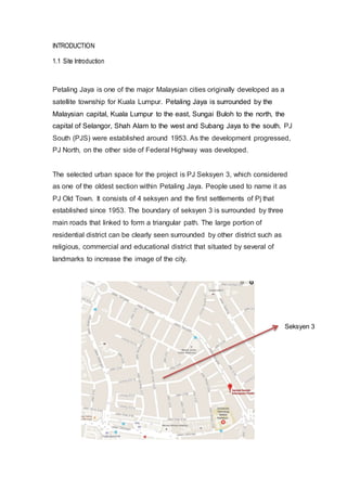
- 1. INTRODUCTION 1.1 Site Introduction Petaling Jaya is one of the major Malaysian cities originally developed as a satellite township for Kuala Lumpur. Petaling Jaya is surrounded by the Malaysian capital, Kuala Lumpur to the east, Sungai Buloh to the north, the capital of Selangor, Shah Alam to the west and Subang Jaya to the south. PJ South (PJS) were established around 1953. As the development progressed, PJ North, on the other side of Federal Highway was developed. The selected urban space for the project is PJ Seksyen 3, which considered as one of the oldest section within Petaling Jaya. People used to name it as PJ Old Town. It consists of 4 seksyen and the first settlements of Pj that established since 1953. The boundary of seksyen 3 is surrounded by three main roads that linked to form a triangular path. The large portion of residential district can be clearly seen surrounded by other district such as religious, commercial and educational district that situated by several of landmarks to increase the image of the city. Seksyen 3
- 2. 1.2 Introductionof Cognitive Mapping Edward C.Tolman first introduced the idea of Cognitive Map while doing an experiment involving rats and mazes in 1948. A cognitive map is a kind of mental representation to serve a person to recall the memories to the specific locations to aid navigation. Cognitive map can be represented in two separate ways. The first is the bearing map, which creates the rough 2D map of the environment through self-movement cues and gradient cues. The second map uses to integrate specific objects or landmark of the environment to the specific locations. Normally, cognitive map used to draw by a person from their memory of the city and the place they living to get a sense of which part of city is more substantial and imaginable. Example of the Kevin Lynch Cognitive Mapping
- 3. 2. COMPARATIVE ESSAY In urban design, Kevin Lynch used to sketch maps in order to understand on how people perceive their environment so the design can be responded to the deepest human needs. This concept not only helps to make cities more imaginable but create more psychologically satisfying urban environments. While doing the research, cognitive mapping was done to indicate the 5 elements such as districts, edges, paths, nodes and landmarks. From the cognitive mapping, there are certain district can be clearly identified. As Kelvin Lynch stated in his book, districts consists of different boundaries, which the observer can mentally go inside of which may have some common character. They can perceive internally, and occasionally can be used as external reference as a person goes by or toward them. In pjs3, the building typology can be classified as cultural, residential, commercial, cooperate and educational. The district was distinctive by contrast to the rest of the city and could be recognized immediately by the people in pj3. According to the site visit, residential district can be obviously seen that occupied large portion of the area in pjs3, which surrounded by other district. Most of the residents have the religion of Muslim, as a mosque was located facing the Jalan Templer that considered as religion district by bringing in the Muslim to be living around here. Besides, the corporate and commercial district are located facing south of the city along the main road of Jalan Othman that provide the daily needs to residents of pjs3 and other city nearby. While at the end corner of Jalan Othman, the education district can be noticed where the campuses located to provide the education to the young generation not only within the city but different scale of other cities in Petaling Jaya. Small portion of educational district can also be found within the area of the residential district to serve the Muslim students for the education within the city.
- 4. However, there are few landmarks can be easily identified along the site visit based on the functions or design of the building itself. Those landmarks are the Masjid Jamek Sultan Abdul Aziz, Menara Mutiara Majestic, UOB bank, Community Library Petaling Jaya and Digistar Holding sdn.bhd. In Kelvin Lynch concept, landmarks are the simple physical elements that familiar within a city and it became more easily identifiable or to be chosen as significant of the city, if they have a clear form and some prominence of spatial location. Those landmarks that mentioned are some of the obvious example of the theory that stated by Kevin Lynch in term of the materials, colours and forms of the building itself. It was done when they appeared to be different from the background by attracting the observer view at the first time and tend to remember it who are not familiar in this place during the site visit. For instance, Masjid Jamek Sultan Abdul Aziz became a landmark for the followers of Muslim who came here to worship. People used to remember the mosque as it brought in the Islam culture to the city and people came here for the worship purpose in every week. It also directly set in mind that it became one of the cultural landmarks that lead to the population of the Muslim in the city when the people passing by. Another example is a stadium, which under Malay house that close to the Mosque
- 5. the Digistar Holding sdn.bhd located towards the end path of Jalan Sentosa. Despite the fact that there are less people went to the stadium using the facilities provided, the colorful large open space used to attract the first view of observer while waiting the traffic at the junction as one of the nodes in city. Furthermore, landmark can also be used as a guidance or direction that make immediate effect on route discover to a certain location. For instance, people can be easily noticed the presence of Menara Mutiara Majestic as the landmark while they passing through Jalan Othman as it is the tallest building and red shading on the whole façade that different from other buildings. By pointing the dominant landmark, people tend to recognize the routine while heading the specific location by marking the building as their part of the memory. Stadium Menara Mutiara Majestic
- 6. In addition, the boundaries between two different districts usually create edges, which are the linear elements but not considered as paths. For an observer, the big and high circulation main road can be identified as the strong edges that surrounded the city and it separated away from other city. The edges are form by three different main roads, which are Jalan Othman, Jalan Selangor and Jalan Templer. Within the city, secondary edges can be determined to separate the two main districts, which is Jalan Rida. The commercial and corporate district can be found to line up along the Jalan Rida that set a boundary away from residential districts. As Kevin Lynch stated that nodes are the strategic foci into which observer can enter, typically junctions of path. The commercial and corporate shop lots that facing linearly along Jalan Othman directly form little small nodes for the people to stop by at each shop lot and they end up as a linear nodes. Furthermore, the bus stops around the ss3 also playing the vital city nodes although their significance may decay. For example, Jalan Othman bus stop as one of the nodes that gather the people at the commercial and corporate district for the working and shopping purposes. There are also another bus stops that situated right in front of the campus, mosque and community library to gather the people before they heading to those places. Kevin Lynch also stated that the junction, or place of a break in transportation has compelling importance for the city observer. Along the boundary of city, most of landmarks can be discovered located at the junctions that highlight the attention of the people who stopping at the junction. For instance, UOB bank located close to the junction at the starting point of Jalan Othman while the Uitm campus has been spot at another junction toward the end of the road. So it automatically can be assumed to derive special prominence from their location. Within the ss3, nodes also can be found where the people stop their vehicle in front primary schools while waiting for their children in the afternoon. Besides, the Muslims also park their vehicles at the junctions to the mosque also directly form a node within the city.
- 7. Based on the research, the different path has been identified refer to the density of the circulation along the pathway. For most people, paths were the dominant city elements, although their importance varied according to the degree of familiarity with the city. Jalan Kawasan Melayu as the main road for most of the residents to access to the heart of the city as it linked to most of the secondary roads before heading to their living locations. It can be clearly seen that separate two parts of the city at the middle which people may also used the road as a shortcut directly to Jalan Selangor without the road traffic. Besides. Jalan Sentosa and Jalan Masjid also known as the primary route that linked from Jalan Kawasan Melayu to the Jalan Othman where most of the landmark and services located to provide the needs of the residents. Thus, the primary route has become the most memorable path for local access the city. However, the secondary route that linked from the primary route is meant to be narrow and normally used by the residents before access to their specific living location. Besides, the people used to get their daily needs such as food and accessories also use the secondary route. So the one-way secondary routes within the commercial and corporate district directly provide the pedestrian path for them to walk along for their destinations. In addition, there are some routes only used by the residents UOB bank close to the Junction
- 8. from the secondary route to their specific living location. The routes are normally short and have death end to control the accessibility of the vehicles. Jalan Kawasan Melayu
- 9. 4. Conclusion Using those specific forms, which defined as “five elements”, can create a perfect city. The five elements classified as paths, edges, districts, nodes and landmarks. The boundary of the city clarified as the edges where most of the landmarks located. Besides, most of the length is accessible and visible to all at the edges of the city. However, the paths need to be strengthening, as it is not significance to the outsider. Character spatial qualities were able to strengthen the image of particular paths such as width of the street. The primary route within the city should be wider compared to the secondary route in order to lead the driver in or out of the city. When major paths lack identity or easily confused one for the other, the entire city image will be in difficulty. People tend to think of path destinations and origin points so it is important to have clear and well-known origins, which can be found lacking from the city. The landmarks that found within the city seemed to have tendency for those who familiar with the city and rely increase the systems of landmarks on their guide. In term of nodes, there are lot of junctions can been seen around the city which make the people heighten their attention at such places and perceive nearby elements with more than normal clarity. In the conclusion, this project used to teach how to apply the Kevin Lynch concept for the better urban planning and design strategies.