Climate change mitigation and agricultural development scenarios for the high plains of Eastern Colombia
•Télécharger en tant que PPTX, PDF•
1 j'aime•591 vues

Climate change mitigation and agricultural development scenarios for the high plains of Eastern Colombia Poster presented at the 3rd Global Science Conference on Climate-Smart Agriculture in Montpellier. Read more: http://ccafs.cgiar.org/3rd-global-science-conference-%E2%80%9Cclimate-smart-agriculture-2015%E2%80%9D#.VRurLUesXX4
Recommandé

Recommandé
Contenu connexe
Tendances
Tendances (20)
Similaire à Climate change mitigation and agricultural development scenarios for the high plains of Eastern Colombia
Similaire à Climate change mitigation and agricultural development scenarios for the high plains of Eastern Colombia (20)
Plus de CCAFS | CGIAR Research Program on Climate Change, Agriculture and Food Security
Plus de CCAFS | CGIAR Research Program on Climate Change, Agriculture and Food Security (20)
Climate change mitigation and agricultural development scenarios for the high plains of Eastern Colombia
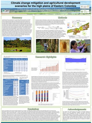
- 1. Agricultural land use intensification can potentially reduce net emissions in the high plains of Eastern Colombia (Figure 1). However, greater intensification depends on economic feasibility and the practicality of land-use change, topics that have not yet been thoroughly investigated. This study used greenhouse gas and opportunity cost estimation tools to evaluate profitability of land-use changes and agricultural practices in the context of their impacts on carbon emissions and accumulation. The study combined field measurements and secondary information on carbon stocks, a 2010 land-use map and projections of future land use changes and estimates of the profitability of land-use. The results showed that several ongoing land use transitions – from native savanna to improved pastures and tree based systems – lead to reduced net emissions and are profitable for agricultural producers. Under different scenarios of future land use change, higher levels of carbon could be sequestered in the coming decade. While there may be overall carbon accumulation, emissions would also rise from increasing agricultural land use intensification. Net emissions in this region could potentially be reduced at a level equivalent to 5% of Colombia’s overall emissions from deforestation and land-use change. More research is needed to improve estimates and better understand the economics and finance of emissions policies and programs. This research was made possible by the support of Colombia’s Ministry of Agriculture and Rural Development (MADR) and National Agricultural Research Institute (CORPOICA). This work was undertaken as part of the CGIAR Research Program on Climate Change, Agriculture and Food Security (CCAFS), which is a strategic partnership of CGIAR and Future Earth. Support was also provided by the CGIAR Research Program on Forest Trees and Agroforestry (FTA). The views expressed in this document cannot be taken to reflect the official opinions of the government of Colombia, the CGIAR or Future Earth. Policies and programs that promote already-existing land use changes in the high plains of Eastern Colombia could substantially reduce net emissions from deforestation and land-use change. A larger number of cattle ranchers could cultivate improved pastures and/or develop silvopastoral systems. Development of tree plantations – rubber, oil palm and timber – is a high carbon development pathway. The changes may be feasible because they are profitable to agricultural producers. One possible reason that we do not see more of these changes already is because farmers do not have the initial startup cost that would be needed to make investments in high carbon land-use. Other important factors may be the lack of infrastructure for agricultural development, land speculation and cultural factors. Intensifying agricultural land use is difficult where farms are isolated and remote, with inadequate transport networks. The high plains have historically been the target of land speculation, with owners more interested in the value of their land for future sale, as opposed to its current agricultural production capacity. Livestock keepers may lack the knowledge and interest in changing their land-use. Plantation forestry is relatively new to the area, hindering the potential for rapid growth. Despite these obstacles, the potential for reducing greenhouse gas emissions in the high plains region is very high. Greater consideration of other ecosystems services is needed to guide land use planning in the region. More research needs to be carried out to guide policies and programs for sustainable development in the region. G. Hyman1, A. Castro2, I.M. Rao1, M. Peters1, A. Loboguerrero1,3 O. Rivera1 and S. Castaño1 (1) International Center for Tropical Agriculture (CIAT), Cali, Colombia; (2) Food and Agriculture Organization (FAO), Rome, Italy; (3) CGIAR Research on Climate Change and Agricultural Food Security (CCAFS) Climate change mitigation and agricultural development scenarios for the high plains of Eastern Colombia 𝑂𝑝𝑝𝑜𝑟𝑡𝑢𝑛𝑖𝑡𝑦 𝑐𝑜𝑠𝑡 𝑈𝑆$ 𝑡𝐶𝑂2 𝑒 = 𝑁𝑃𝑉𝑖𝑛𝑖𝑡𝑖𝑎𝑙 − 𝑁𝑃𝑉𝑎𝑙𝑡𝑒𝑟𝑛𝑎𝑡𝑖𝑣𝑒 𝑈𝑆$ ℎ𝑎 𝑐𝑎𝑟𝑏𝑜𝑛𝑖𝑛𝑖𝑡𝑖𝑎𝑙 − 𝑐𝑎𝑟𝑏𝑜𝑛 𝑎𝑙𝑡𝑒𝑟𝑛𝑎𝑡𝑖𝑣𝑒 𝑡𝐶 ℎ𝑎 ∗ 3.67 𝑡𝐶𝑂2 𝑒 𝑡𝐶 The study combines information on carbon stocks, land-use systems and the profitability of land-use systems to estimate how changes in any of these variables would affect greenhouse gas (GHG) emissions and livelihoods. The method applies the concept of opportunity costs to account for the land use change impacts on GHG and livelihoods from alternative land uses and practices. The critical part of the analysis quantifies these changes according to the following equation: The opportunity cost is expressed as the profitability (or net present value – NPV) of changing a land-use per ton of CO2 equivalent of GHG emitted or sequestered in relation to that environmental impact change. The change in net present value (VPN) or profitability of an initial land-use activity compared to an alternative activity is calculated. Then, the associated changes in carbon stocks between these activities are calculated. By expressing these changes in terms of the profitability of the change per ton of GHG emitted or sequestered, we can better understand the balance and trade-offs between different land uses in terms of their livelihood and environmental impacts. Category Net present value (US$ per ha) Oil palm 914 Forestry plantation 500 Crop-pasture-tree mosaic 500 Pasture with trees 426 Weedy pastures 426 Cultivated Pastures 426 Rubber 418 Rice 415 Other annual crops 173 Native savanna 100 Forest 0 Secondary Vegetation 0 Table 1. Above and below ground carbon stocks and emissions fluxes in the Eastern plains of Colombia in Mg C ha-1. Land Use 2010-2011 Area (ha) Area (%) Native savanna 324,021 33.39 Forest 182,917 18.85 Mosaic of crops, pastures and trees 134,248 13.83 Pastures 117,674 12.13 Without vegetation (water, bare soil, clouds, transportation infrastructure, urban) 67,442 6.95 Secondary vegetation 44,049 4.54 Pastures with trees 39,775 4.1 Forest plantation 20,576 2.12 Oil palm 12,293 1.27 Other annual crops 11,912 1.23 Rubber 10,474 1.08 Rice 3,370 0.35 Weedy pastures 1,615 0.17 TOTAL 970,366 100 Table 2. Land Use in the high plains of Eastern Colombia. Table 3. Net present value (NPV) in the high plains of Eastern Colombia Figure 2. Averages and ranges of soil carbon stock in the high plains of Eastern Colombia. Figure 3. Expected land use changes under a “business as usual” scenario in the high plains of Eastern Colombia. Figure 4. Opportunity cost curve for the high plains of Eastern Colombia. -40,000,000 -35,000,000 -30,000,000 -25,000,000 -20,000,000 -15,000,000 -10,000,000 -5,000,000 0 2002-20010 2010-2018 2018-2026 2026-2034 2034-2042 Cumulativenetemission MgCO2eq Time period BAU 50% 100% Above ground carbon stocks reported here are a combination of primary data from field measurements and values from similar environments reported in the literature (Table 1; MADR- CORPOICA-CIAT. 2012; Lavelle et al., 2014). Land uses in the study area are dominated by native savannas, forests, improved pastures and mosaics of these 3 land covers (Table 2; Rodriguez et al., 2012). According to Rodriguez and others (2012), over one third or nearly 325,000 ha of the region is comprised of native savannas with varying densities of grasses, shrubs and small trees. The 2nd most abundant land use/land cover is forests, making up less than 20% of the region. Many of these forests are gallery forests along water courses. Improved pastures make up 12% of the study area and are growing. Tree plantations and annual crops cover relatively small proportions of the study area but are growing rapidly. The net present values of land-use in the high plains vary according to the intensity of the land-use activity (Table 3). While these values are preliminary, they do show that native savanna – the largest land-use area – is less profitable than several other land-use activities that have higher carbon stocks, such as oil palm, forestry plantations, cultivated pastures and others. Average belowground and above ground carbon stocks vary substantially by land-use across the region. Soil carbon stocks measured in the field during this study varied from less than 50 tons of carbon per hectare in forested areas to over 150 tons per hectare in sugarcane areas (Figure 2). Lower soil carbon stocks were found in rice areas and natural savanna areas. Intermediate values were found in tree plantations such as oil palm, rubber and timber plantations as well as improved pastures. Areas with sugarcane, fragmented forests and pastures with trees had some of the highest values for belowground carbon stocks. Land use intensification is expected to be the dominant land use change over the next decades (Figure 3). The estimates of future land use reported here are based on the scientific literature and government statistics (Etter et al., 2010; MADR, 2014). The most important change is the reduction of area in native savanna. Forested areas also are expected to continue decreasing. Cultivated pastures are expected to increase and will become the land-use with the largest area. Recent trends point to increases in timber, oil palm and rubber plantations. Rice and other annual crops will also increase in the coming years. All the changes described above reflect growing interest in the high plains region as a focus of agricultural development. Land Use (2011/2012) Above- ground Above- ground source Below- ground Below- ground source Total Annual Flux Forestry plantation 90 * 127 *** 217 Forest (fragmented, riparian, high density of land, high density flooded) 90 *** 108 *** 198 Pastures with trees 47 ** 134 *** 181 3.6 Oil palm 50 **** 110 *** 160 Secondary vegetation 90 * 55 ** 145 Mosaic of crops, pastures and natural vegetation 32 ** 111 ** 143 Rubber plantation 20 *** 113 *** 133 Improved pastures 4 **** 116 *** 120 3.6 Native savanna 3 **** 72 *** 75 1.92 Rice 3 *** 70 *** 73 1 Other annual crops 3 *** 70 † 73 1 Degraded pasture 4 †† 60 ††† 64 3.6 * From global estimate ** Average of component land uses *** From field studies by CIAT and CORPOICA **** secondary data measured in the Colombian Llanos (Etter, Castilla) † assumed the same as rice †† assumed the same as improved pastures ††† assumed as 50% of improved pastures Source: Rodriguez et al., 2012; CORPOICA The opportunity cost curve in figure 4 suggests several possibilities for low emissions development in the high plains of eastern Colombia. Three key land-use transitions are principal drivers of emissions in the region – forest to rice, forest to pastures and forest to mosaic landscapes (the bars to the right of 0 on the x-axis). The opportunity costs of converting forest to other land uses are relatively low, suggesting some scope for programs that could avoid emissions by compensating landowners for forgoing rice growing and cattle ranching activities. Land use transitions leading to carbon accumulation have greater potential than those that avoid emissions. The land-use with the greatest area in the high plains region – native savanna – also has the lowest carbon stocks. Therefore conversions of native savanna lead to carbon accumulation (the bars to the left of 0 on the x-axis). These transitions are also profitable, bringing benefits to land owners of between $1 and $3 per ton of CO2 equivalent sequestered (the bars above 0 on the y-axis). Since landowners are already making profits by converting native savanna, this may be a land-use that could be encouraged by government policies that might provide credit or other programs encouraging adoption of high carbon stock land uses. Figure 5. Net emissions scenarios for the high plains of Eastern Colombia, 2002 to 2042. BAU is our business as usual projection of land-use change over the next decade. The 50% and 100% scenarios assume that growth of tree plantations and improved pastures would increase by half as much or double over the next decades. The impact of future land use change on net emissions suggests that accumulation will continue but will be less important as opportunities for land-use conversions that reduce emissions decline (Figure 5). Carbon accumulation advances in the 1st years of the simulation but declines later as emissions from agriculture increase and fewer opportunities for converting native savanna to higher carbon stock land uses. Figure 1. Land use in the high plains of Eastern Colombia, 2010/2011.