SlideShare une entreprise Scribd logo
1  sur  16
Télécharger pour lire hors ligne
1
U.S. Pacific Remote Islands Marine National Monument
Proposed Monument Expansion
Confidential Background Dossier
Prepared by:
The Pew Charitable Trusts
June 2014
2
Table of Contents
Proposed Expansion of U.S. Remote Islands Marine National Monument..................................................3
2009 Declaration of U.S. Pacific Remote Islands Marine National Monument...........................................3
Monument Size.............................................................................................................................................4
Unique Ecology, Biodiversity and History...................................................................................................7
Seamounts.....................................................................................................................................................7
Ecological Connectivity between Atolls.......................................................................................................9
Kingman and Palmyra.................................................................................................................................11
Wake ...........................................................................................................................................................11
Johnston ......................................................................................................................................................12
Howland, Baker, and Jarvis ........................................................................................................................12
Tuna fisheries and bycatch..........................................................................................................................13
Economic and scientific rationale...............................................................................................................16
3
Proposed Expansion of U.S. Remote Islands Marine National Monument
The Pacific Remote Islands Marine National Monument currently covers 212,714 square kilometers
(82,129 square miles) encompassing seven islands and atolls in the central Pacific Ocean, including
Wake, Johnston, Howland and Baker, Kingman and Palmyra, and Jarvis.1 2
Of these, Howland, Baker,
and Jarvis Islands; Palmyra Atoll; and Kingman Reef, including their terrestrial areas, reef, and waters out
to 12 nm, are part of the National Wildlife Refuge System. Johnston Atoll and Wake Island and their
waters out to 12 nm are also part of the National Wildlife Refuge System. The Department of Defense
manages “emergent lands.”
A recent article published in Nature concluded that MPA effectiveness was strongly associated with
several key variables including size and isolation, among others.3
These seven atolls and islands are
farther from human population centers than any other U.S. area, and extending the National Marine
Monument designation to 200 nautical miles could safeguard one of the last remaining pristine areas in
U.S. waters from future exploitation.
2009 Declaration of U.S. Pacific Remote Islands Marine National Monument
Through the use of the Antiquities Act, President George W. Bush was able to set these areas aside under
federal jurisdiction for “the protection of objects of historic and scientific interest.” According to the
proclamation, “the monument includes the waters and submerged and emergent lands of the Pacific
Remote Islands to the lines of latitude and longitude depicted on the accompanying maps, which lie
approximately 50 nautical miles from the mean low water lines of Wake, Baker, Howland, and Jarvis
Islands, Johnston Atoll, Kingman Reef, and Palmyra Atoll.”4
The U.S. Fish and Wildlife Service (USFWS) currently manages from the mean low water line out to 12
nm, while the National Oceanic and Atmospheric Administration (NOAA) Fisheries manages fishing-
related activities from 12-50 nautical miles. It is possible to expand the monuments outward from the
current area of about 50 nautical miles around each atoll and island to 200 nautical miles, the full expanse
of the U.S jurisdiction surrounding each atoll.5
Commercial fishing is prohibited throughout the existing designated areas. Subject to USFWS authority,
non-commercial fishing may be allowed in consultation with NOAA Fisheries and the Western Pacific
Fishery Management Council (WPFMC). Recreational fishing is restricted to specific locations in
accordance with the proclamation. 6
From 50 to 200 nm (outside of the national marine monument
boundary), WPFMC manages fishery resources through the “Fishery Ecosystem Plan for the Pacific
Remote Islands Areas” and the “Pacific Pelagic Fishery Ecosystem Plan.” Currently, there is little fishing
except for tuna fishing.
1
http://www.fpir.noaa.gov/MNM/mnm_prias.html
2
http://marineprotectedareas.noaa.gov/dataanalysis/mpainventory/mpaviewer/
3
Edgar, G. et al. Global conservation outcomes depend on marine protected areas with five key features.
Nature 506, 216–220 (2014
4
http://www.fws.gov/pacificremoteislandsmarinemonument/PP%20PRIMNM.pdf
5
http://www.fws.gov/pacificremoteislandsmarinemonument/PRIMNM%20brief.pdf
6
http://www.fws.gov/pacificremoteislandsmarinemonument/PP%20PRIMNM.pdf
4
Monument Size
The 5 atoll groups that make up the Pacific Remote Islands Marine National Monument currently cover
an area approximately 212,714 km2
spread over a wide swath of the Pacific Ocean. Expanding the Pacific
Remote Islands Marine National Monument to the full 200 nautical miles exclusive economic zone
boundary would increase the size of the area encompassed within no-take marine reserves by more than
1,700,000 km2
. These five areas together would create a series of protected areas totaling more than two
million square kilometers.
Chart 1: Atoll group size
Site Name
Area of Existing
Monuments in square
kilometers
Area of Monument
expansions in square
kilometer(total, includes
existing monument area)
Wake Island 39069 433398
Jarvis Island 35486 318109
Howland Island
and Baker Island 51896 437102
Palmyra Atoll 54050 350498
Johnston Atoll 39871 464013
TOTALS 220372 2003120
AREA ADDED (TOTAL -
EXISTING) = 1782748
The first chart below compares the current Pacific Remote Islands Marine National Monument with other
no-take areas around the world (comparisons are included for the both the aggregated total as well as the
individual atolls.) Currently the individual sites rank as 8th
, 9th
, 11th
, 12th
, and 13th
in size. The second
chart shows where these areas would rank if expanded to the full 200 nautical mile border. The individual
atolls would rank 3rd
, 4th
, 5th
, 7th
, and 8th
in largest no-take areas globally.
5
Chart 2: Current rankings of large, no-take reserves.
Marine Reserve Size (sq km) Percent No-Take No-Take Size (sq km)
Chagos 640,000 100 640,000
Coral Sea 501,723 100 501,723
Papahanaumokuakea 363,000 100 363,000
Motu Motrio Hiva 150,000 100 150,000
Great Barrier Reef 344,000 34 124,000
South Orkney Islands 94,000 100 94,000
Macquarie Island 162,000 36 58,300
Kingman and Palmyra 54,021 100 54,021
Howland and Baker 53,270 100 53,270
Marianas Trench 246,000 17 42,000
Wake 36,762 100 36,762
Johnston 36,059 100 36,059
Jarvis 35,784 100 35,784
Rose Atoll 34,000 100 34,000
Phoenix Island (Kiribati) 410,000 3.7 15,000
Chart 3: Rankings of no-take reserves if Pacific Remote Islands Marine Monument is expanded
Marine Reserve Size (sq km) Percent No-Take No-Take Size (sq km)
Chagos 640,000 100 640,000
Coral Sea 501,723 100 501,723
Johnston 442,635 100 442,635
Howland and Baker 434,921 100 434,921
Wake 407,241 100 407,241
Papahanaumokuakea 363,000 100 363,000
Kingman and Palmyra 352,300 100 352,300
Jarvis 316,665 100 316,665
Motu Motrio Hiva 150,000 100 150,000
Great Barrier Reef 344,000 34 124,000
South Orkney Islands 94,000 100 94,000
Macquarie Island 162,000 36 58,300
Marianas Trench 246,000 17 42,000
Rose Atoll 34,000 100 34,000
Phoenix Island (Kiribati) 410,000 3.7 15,000
6
Chart 4: Overview of EEZ size and marine reserves by country.
Country Marine Protections
Australia • Australia has the 3rd
largest EEZ and has protected 8% as no-take marine
reserves.
• Coral Sea Marine Reserve: 501,723 sq km; 100% no-take
• Great Barrier Reef Marine Park: 344,000 sq km; 34% no-take
• Macquarie Island Marine Reserve: 162,000 sq km; 36% no-take
Chile • Chile has the 11th
largest EEZ and has protected 4% as no-take marine
reserves.
• Motu Motrio Hiva Marine Park: 150,000 sq km; 100% no take
Palau • In February of this year, Palau’s President, Tommy Remengesau announced
his intent to close his EEZ to industrial scale fishing and create a marine
sanctuary.
• Palau is an important partner to the United States.
• The Pivot to the Pacific is about global security and protecting Palau’s rich
marine diversity helps increase resilience to climate change.
• Once finalized Palau will protect up to 80% of its EEZ as a no-take marine
sanctuary.
• No other country in the world has protected this much ocean--President
Remengesau should be commended for his conservation leadership
Kiribati • When Kiribati announces that commercial fishing will cease in the Phoenix
Islands it will have protected nearly 12% of its EEZ.
• Phoenix Islands Protected Area is currently on 3.7% no-take or 15,000 sq
km
• Once fully protected the Phoenix Islands area will be one of the largest no-
take reserves in the world at 410,000 sq km.
United Kingdom • In 2010, the U.K. created the largest no-take marine reserve in the world in
the Indian Ocean.
• With the 5th
largest EEZ in the world the U.K. has protected nearly 11% of
its EEZ.
• Chagos Marine Reserve: 640,000 sq km; 100% no-take
• South Orkney Islands Marine Protected Area: 94,000 sq km; 100% no-take
United States • The U.S. has the largest EEZ in the world and we currently protect less than
6% in no-take marine reserves. By expanding the Pacific Remote Islands
National Monument to the full potential of the atolls we are adding nearly
1.8 million square kilometers of fully protected reserves to the world’s
oceans. This is an area greater than the size of Alaska and nearly doubles
the amount of ocean ecosystems currently protected as no-take reserves.
• Papahanaumokuakea Marine Monument: 363,000sq km; 100% no-take
• Marianas Trench Marine Monument: 246,000 sq km; 17% no-take
• Rose Atoll Marine Monument: 34,000sq km; 100% no-take
• Remote Pacific Islands Marine Monument: 220,732 sq km; 100% no-take
• Expanded Remote Pacific Islands Marine Monument: 2,003,120 sq km;
100% no-take
7
Unique Ecology, Biodiversity and History
“Deep coral forests occur below photic zones of all three islands at depths below 200 meters, especially
at Jarvis where surveys have revealed living colonies of precious and ancient gold coral up to 5,000
years old.”7
The waters surrounding Baker, Howland, and Jarvis Islands have fish biomass double that of the
Papahanaumokuakea Marine National Monument, and 16 times that of the main Hawaiian Islands, due to
the Equatorial Undercurrent that moves from west to east along the equator, creating localized nutrient-
rich upwellings in the shallows next to the islands. These are three of only six islands in the entire Pacific
Ocean where this phenomenon is possible.8
The reefs at Kingman and Palmyra have set a new ecological baseline for coral reefs, and they changed
what we expect reefs to look like. “Kingman Reef has the greatest known fish biomass and proportion of
apex predators of any coral reef ecosystem that has been scientifically studied in the world.”9
Kingman is
also one of the world's most pristine coral reefs, and should serve as a baseline for future studies of coral
reef microbes.10
Kingman and Palmyra have shown that there is a direct relationship between fishing and
coral disease.11
Johnston Atoll has shown low levels of coral disease, which provides an important
baseline, especially in relation to climate change.
With marine protected areas, differences in fish-assemblage structure have been observed between fished
and unfished atolls in the northern Line Islands of the central Pacific. “Fish assemblages at Palmyra and
especially Kingman atolls were characterized by high total standing biomass, large average body sizes, a
preponderance of apex predators and other piscivorous fishes in an inverted biomass pyramid, few and
small planktivorous fishes, and herbivores dominated by non-territorial species.”12
By comparing uninhabited areas to human-impacted areas within the Pacific, one study was able to re-
create missing population baselines for Pacific reef sharks and found that reef shark populations increased
when human population decreased.13
Historically, Wake, Johnston, and Howland witnessed fighting during WWII. In the late 1800s, the
Howland, a whaling ship, wrecked at Johnston Atoll. Amelia Earhart was flying to Howland when her
plane was lost.
Seamounts
In the total proposed expanded area for protection in the EEZs around these five islands, there are
approximately 251 seamounts,14
which are underwater mountains, rising 1,000 meters or higher from the
seabed without breaking the ocean's surface. The vast majority of these seamounts are virtually
unexplored, supporting biodiversity-rich communities that are some of the most poorly understood in the
7
http://www.fws.gov/pacificremoteislandsmarinemonument/PP%20PRIMNM.pdf
8
http://www.fws.gov/pacificremoteislandsmarinemonument/PP%20PRIMNM.pdf
9
Federal register, Vol. 76, No. 65/Tuesday April 5, 2011
10
Microbial Ecology of Four Coral Atolls in the Northern Line Islands,
http://scrippsscholars.ucsd.edu/ssandin/content/microbial-ecology-four-coral-atolls-northern-line-islands-1
11
http://www.asmcue.org/documents/Rohwer-ASMCUE-Corals5-19-10.pdf
12
http://scrippsscholars.ucsd.edu/ssandin/content/differences-fish-assemblage-structure-between-fished-and-
unfished-atolls-northern-line-islan
13
http://onlinelibrary.wiley.com/doi/10.1111/j.1523-1739.2012.01835.x/abstract
14
http://seaaroundus.org/ecosystemsmaps/default.aspx
8
world.15
Every research expedition in these waters discovers large numbers of new species,16
such as
previously unrecorded species of deep-water algae, coral, and fish.17
Chart 5: Seamount located in PRIA.
Site Name
Seamount counts in existing
monuments
Seamount counts in Monument
expansion areas (total, includes
existing area)
Wake Island 8 40
Jarvis Island 4 24
Howland Island and
Baker Island 5 21
Palmyra Atoll 26 68
Johnston Atoll 10 98
TOTALS 53 251
Scientists estimate that there are as many as 10 million species inhabiting the deep sea-- biodiversity
comparable to the world's richest tropical rainforests. Deep-sea species tend to be slow growing, late
maturing and endemic, making them particularly vulnerable to extinction.18
Much of the biodiversity in
the deep sea is concentrated around seamounts. They are home to cold-water coral reefs and forests,
sponge beds, and hydrothermal vents, as well as large marine mammals, such as dolphins and whales, and
an extraordinary diversity of fish, creating one of the world’s greatest marine-biological treasures.19
The relatively few number of studies conducted in these waters have observed a total of 506 shore-fish
species, and 27 epipelagic species have been recorded from these five islands.20
These waters also support
many marine mammals, including sei whales, sperm whales, striped dolphins, false killer whales, melon-
headed whales, and spotted dolphins, frequent populations of minke and humpback whales.21
According
to the Fish and Wildlife Service, “these areas represent the last refugia for fish and wildlife species
rapidly vanishing from the remainder of the planet, including sea turtles, dolphins, whales, pearl oysters,
giant clams, coconut crabs, large groupers, sharks, humphead wrasses, and humphead parrotfishes. Fish
biomass at these islands is remarkable.”22
These remote underwater “islands” provide an important source of food due to their nutrient upwellings
and strong localized currents, which attract massive quantities of plankton. At the base of the food web,
15
Mundy et al, 2010, http://www.pifsc.noaa.gov/library/pubs/Mundy_etal_ARB_585_2010.pdf
16
Parrish and Baco, 2006, http://www.coris.noaa.gov/activities/deepcoral_rpt/Chapter4_HawaiiPacific.pdf
17
http://www.papahanaumokuakea.gov/research/biogeographic_cruise2013.html
18
Deep Sea Conservation Coalition, http://savethehighseas.org/deepsea/
19
Ibid.
20
Mundy, et al, 2010, http://www.pifsc.noaa.gov/library/pubs/Mundy_etal_ARB_585_2010.pdf
21
http://www.pifsc.noaa.gov/qrb/2010_06/article_12.php
22
http://www.fws.gov/pacificremoteislandsmarinemonument/PRIMNM%20brief.pdf
9
these plankton hotspots are prime deep-sea feeding and spawning grounds, providing a pit stop for
various pelagic species as they migrate through the vast open ocean.23
The deep sea is also home to remarkably rich coral systems. While more is known about shallow coral
ecosystems, it is now thought that there are more coral species living at great ocean depths than in tropical
shallows. These ancient corals, some as old as 8,000 years, create ornate, forest-like structures that would
take hundreds of years to recover if disturbed by fishing activities such as bottom-trawling.24
These
species rich waters host expansive shallow coral reefs and deep coral forests; the oldest corals observed in
these deep waters are up to 5,000 years old.25
Ecological Connectivity between Atolls
This collection of interconnected refuges serves as “key stepping stones for the colonization and dispersal
of species between the eastern and western, and the northern and southern Pacific Ocean. Some of these
refuges are also unique in that they benefit from localized upwelling from the Equatorial Undercurrent,
23
Ibid.
24
http://www.pewenvironment.org/campaigns/protecting-the-deep-sea/id/8589940401
25
http://www.fws.gov/pacificremoteislandsmarinemonument/PRIMNM%20brief.pdf
10
and others serve as destinations for additional species transported from the western Pacific by the
Equatorial Countercurrent.”26
Palmyra Atoll lies within the inter-tropical convergence zone and path of the eastward moving Equatorial
Countercurrent, which bring larvae of additional reef species from the more diverse West Pacific.27
The
deep-sea Equatorial Undercurrent moves from west to east around these atolls and underwater seamounts,
creating localized nutrient-rich upwellings in shallows next to the islands. In the entire Pacific Ocean, this
only occurs in six islands (three of which are here).28
The Pacific is composed of two large gyres, the
northern and southern central gyres; the complex interactions of these undercurrents contribute to overall
connectivity of the deep-sea ecosystems, providing long-distance dispersal of pelagic larvae. The Pacific
Equatorial Undercurrent moves at depths of 70–200 m, is approximately 450 km wide, and flows with
velocities of up to 5 km/hour for a distance of up to 13,000 km. Jarvis, Howland, and Baker are in the
equatorial system; Kingman and Palmyra are in the equatorial/eastern Pacific current; Hawaii, Wake and
Johnston are in the center of the North Pacific gyre.29
26
Ibid
27
http://mcbi.marine-conservation.org/what/what_pdfs/Palmyra_Factsheet.pdf
28
1566 Federal Register / Vol. 74, No. 7 / Monday, January 12, 2009 Presidential Documents,
http://www.fpir.noaa.gov/Library/MNM/Proclamation%208336%20-%20PRIA.pdf
29
Parrish and Baco, 2006, http://www.coris.noaa.gov/activities/deepcoral_rpt/Chapter4_HawaiiPacific.pdf
11
Kingman and Palmyra
The waters surrounding Kingman and Palmyra comprise one of the world’s last intact coral reef
ecosystems, and its species-rich waters have a higher proportion of apex predators than any other coral
reef ecosystem in the world.30
The Kingman and Palmyra reefs support three times the number of coral
species found in Hawaii and the Caribbean, and five times the number of species found in the Florida
Keys. 31
“Palmyra's reefs look substantially different from all others in the equatorial Pacific, containing food
webs dominated by an abundance of top predators, such as sharks, which have rapidly declined
elsewhere. Indeed, sharks are commonplace at Palmyra. Their presence is a sign of overall reef ecosystem
health and a key reason why the atoll is one of the few places in the world where they can be studied in
natural numbers across their habitat range.”32
Palmyra's waters are teeming with species, including “manta rays, mullets, fusiliers, snappers, green and
hawksbill turtles, humphead parrotfish, pilot whales, humphead wrasses, sharks, other rays, jacks, goat-
fish, tuna, butterflyfish, damselfish, surgeonfish, rare giant clams, black-lipped pearl shells, and pen
shells.”33
Pacific bottle-nosed dolphins, spinner dolphins, and melon-headed whales frequent the waters
of the Refuge, in addition to stony corals.34
Palmyra also supports an array of invertebrates, including 176
stony coral species, 17 benthic cnidarian species, 12 species of macro-invertebrates.35
Palmyra also has 29 bird species including the bristle thighed curlew.36
As one of the world’s healthiest coral ecosystems, Palmyra provides a natural laboratory for studying the
impact of climate change on coral reefs.
Wake
Because access is restricted around Wake, there has been little pressure from the fishing industry and
marine biomass and biodiversity is likely to be extremely high.37
At least 323 species of fish and
approximately 100 species of coral have been reported at Wake Atoll. These waters provide refuge for
many species, which are depleted globally, including several species of sharks and abundant populations
of the Napoleon wrasse.38
Large schools of humphead parrotfish comprise well over half of the total fish
biomass.39
Foraging populations of green turtle (listed as threatened by the Endangered Species Act), as
30
http://www.nature.org/ourinitiatives/regions/northamerica/unitedstates/hawaii/palmyraatoll/explore/expeditio
n-to-palmyra.xml
31
ibid
32
ibid
33
ibid
34
http://www.fws.gov/refuge/Palmyra_Atoll/wildlife_and_habitat/index.html
35
http://mcbi.marine-conservation.org/what/what_pdfs/Palmyra_Factsheet.pdf
36
http://www.fws.gov/refuges/profiles/index.cfm?id=12533
37
http://mcbi.marine-conservation.org/what/what_pdfs/Wake_Factsheet.pdf
38
http://www.fws.gov/refuge/Wake_Atoll/wildlife_and_habitat/index.html
39
NOAA 2009, http://www.pifsc.noaa.gov/qrb/2009_08/article_01.php
12
well as resident populations of spinner dolphins are common.40
Five species of coral found at Wake Atoll
are listed as Vulnerable on the IUCN Red List of Threatened Species (Acropora aculeus, A. acuminata, A.
palmerae, Montipora lobulata, and Pocillopora elegans).41
Wake Atoll hosts a healthy reef ecosystem of
mostly hard (scleractinian) corals. In shallower reef areas, macroalgae are abundant.42
Abundant reef fish
at Wake play the crucial role of grazers, regulating algal growth and enhancing overall coral reef health.43
The rare giant clam thrives here on shallow coral reefs.44
Johnston
More than 300 species of fish have been recorded near the reefs of Johnston Atoll. Other species often
found include the green turtle, reef sharks the Hawaiian monk seal, and humpback whales.45
Fifty-four
species of corals have been reported at Johnston including 49 stony coral species. It supports 54 coral
species, including a thriving table coral community and a dozen species found only in the Hawaiian and
northern Line Islands.46
The most conspicuous species is the giant table coral (Acropora cytherea), which
grows in large horizontal plates.47
The surface of the coral is covered by a thin layer of tissue containing a
photosynthetic algae zooxanthella which provides energy for the coral.48
Johnston Atoll is the sole coral dispersal “stepping stone” into Hawaii.49
Coral spawn in Johnston Atoll is
dispersed to the Hawaiian Islands.50
Expanding the monuments could help maintain these coral spawning
pathways.
Howland, Baker, and Jarvis
“The waters surrounding Baker, Howland, and Jarvis Islands have fish biomass double that of the
Papahanaumokuakea Marine National Monument and 16 times that of the main Hawaiian Islands.”51
“Coral cover and biodiversity is much higher compared to Hawaii and Florida. Beyond the shallow
fringing reefs and terraces, the slopes of the extinct volcanoes drop off sharply to the deep floor of the
equatorial Pacific Ocean. The Equatorial Undercurrent creates a localized nutrient-rich upwelling in the
shallows near the islands, resulting in high fish biomasses and a high proportion of top predators. Up to
340 fish species inhabit these isolated reefs, and giant clams, sharks, and sea turtles are abundant.”52
40
http://www.fws.gov/refuge/Wake_Atoll/wildlife_and_habitat/index.html
41
Kenyon et al, NOAA 2013, http://www.pifsc.noaa.gov/library/pubs/Kenyon_etal_ARB_2013_600.pdf
42
NOAA 2009, http://www.pifsc.noaa.gov/qrb/2009_08/article_01.php
43
Kenyon et al, NOAA 2013, http://www.pifsc.noaa.gov/library/pubs/Kenyon_etal_ARB_2013_600.pdf
44
http://www.fws.gov/pacificremoteislandsmarinemonument/PRIMNM%20brief.pdf
45
http://www.fws.gov/refuge/Johnston_Atoll/wildlife_and_habitat/index.html
46
http://www.fws.gov/pacificremoteislandsmarinemonument/PRIMNM%20brief.pdf
47
http://www.fws.gov/refuge/Johnston_Atoll/wildlife_and_habitat/index.html
48
World Register of Marine Species, http://www.marinespecies.org/aphia.php?p=taxdetails&id=207095
49
http://onlinelibrary.wiley.com/doi/10.1111/geb.12101/abstract
50
http://www.denix.osd.mil/nr/crid/Coral_Reef_Iniative_Database/Johnston_Atoll_files/Kobayashi,%202006.pdf
51
1566 Federal Register / Vol. 74, No. 7 / Monday, January 12, 2009 Presidential Documents,
http://www.fpir.noaa.gov/Library/MNM/Proclamation%208336%20-%20PRIA.pdf
52
http://www.fws.gov/pacificremoteislandsmarinemonument/PRIMNM%20brief.pdf
13
Tuna fisheries and bycatch
There is little fishing within the United States Pacific Remote Island Areas (PRIAs), made up of Wake,
Baker, Howland, and Jarvis Islands, Johnston Atoll, Kingman Reef, and Palmyra Atoll, with the
exception of seasonal, but minimal, fishing by US commercial longline and purse seine tuna vessels. The
tuna caught within these areas represents between 1 and 3 percent of the US tuna catch in the western and
central Pacific.
The US operates one of the world’s largest purse seine fleets in the Pacific Ocean, catching more than
230,000 metric tons of tuna from the western and central Pacific every year valued at more than $500
million53
. The US has 40 large scale purse seine vessels, which primarily fish in the exclusive economic
zones (EEZs) of Pacific Island countries, including Kiribati, Papua New Guinea, and the Marshall Islands.
Occasionally, US purse seiners set their nets in one of the EEZs of the US PRIAs, but no other fleets are
permitted to fish in these areas. Tuna purse seine catch in PRIA EEZs averaged 1,047 metric tons
annually from 2008-201154
, worth an average of $1.4 million per year.55
This represents less than 1
percent of the total US purse seine tuna catch in the western and central Pacific Ocean.
US longline vessels also fish in the EEZs of Palmyra and Johnston Atoll, with effort averaging 3 percent
of western Pacific longline activity from 2008-2011.56
All longline vessels with Hawaii or American
Samoa limited entry longline permits are allowed to fish in the PRIA.57
In 2012, Hawaii’s longline fleet landed $95 million
worth of fish, 58
$4.9 million of which was caught in the
PRIA.59
Seventy-seven longline vessels fished in the
PRIA (out of 129), making 130 trips (9% of all longline
trips), 766 sets (4% of all longline sets), and 1.9 million
hooks (4% of total hooks by the fleet).60
Of note,
should these areas be closed to fishing, because the U.S.
53
Value of Western and Central Pacific Tuna Fisheries. Forum Fisheries Agency 2013.
http://www.ffa.int/node/425#attachments
54
Ibid
55
Ibid
56
Pelagic Fisheries of the Western Pacific Region 2011 Annual Report. Western Pacific Regional Fishery
Management http://wpcouncil.org/wp-
content/uploads/Large%20PDFs/2011%20Pelagics%20Annual%20Report_Final.pdf
57
Western Pacific General Longline Fishing. NOAA Fisheries Service.
http://www.fpir.noaa.gov/SFD/pdfs/Reg%20Summary%20WP%20General%20Longline%20(rev.%207-23-10).pdf
58
Table 9: Hawaii commercial pelagic landings, revenue, and average price by species for the Hawaii-based deep-
set and shallow-set longline fisheries, 2011-2012.Page 83. http://www.wpcouncil.org/wp-
content/uploads/2013/03/BD46_Territory_Limits_FEP_Amd_7___FINAL_transmitted_draft_2013-23-12.pdf
59
Calculated using Table 10: Hawaii commercial pelagic landings, revernue, and average price per pound by
fishery, 2011-2012. Page 83. http://www.wpcouncil.org/wp-
content/uploads/2013/03/BD46_Territory_Limits_FEP_Amd_7___FINAL_transmitted_draft_2013-23-12.pdf, and
the Hawaii-based Longline Logbook Summary Report 2012. http://www.pifsc.noaa.gov/library/pubs/DR-13-
004.pdf
60
The Hawaii-Based Longline Logbook Summary Report 2012. Pacific Islands Fisheries Science Center.
http://www.pifsc.noaa.gov/library/pubs/DR-13-004.pdf
99%
1%
United States Pacific Tuna Purse Seine Catch
233,331 Metric Ton Average Catch
US purse seine
tuna catch outside
PRIA
US purse seine
catch in PRIA
14
can fish on the high seas and in the Hawaii EEZ, their overall catch levels would not be impacted.
Both purse seine and longline fisheries in the PRIAs have significant bycatch concerns. By number,
shark bycatch made up 11 percent of total catches from the longline fishery in the PRIA in 2012,
including catches of threatened silky and oceanic whitetip sharks.61
Billfish caught as bycatch in the
longline fishery, including the overfished striped marlin, made up 4.7 percent of the longline catch in the
PRIA.62
Purse seiners catch threatened shark species as well as high volumes of juvenile bigeye tuna
which are experiencing overfishing throughout the region. The EEZs of the PRIAs contain higher
concentrations of juvenile bigeye than any other area in the western and central Pacific Ocean.63
During El Nino events, there is increased fishing in the Pacific Remote Islands Areas because tuna
populations in the western Pacific migrate east. The last strong El Nino event occurred in 1997-1998,
during which time the U.S. purse seine vessel catch in PRIAs significantly increased.64
Between 2008-
2011, however, the annual value of the U.S. purse seine fleet catch in the Pacific Remote Islands area
ranged from $655,000 to 3.0 million65
. Of note is that should these areas be closed to fishing, because of
the U.S. Tuna Treaty, these vessels can continue to fish in the entire area outside of the Remote Pacific
Island waters without diminishing the total amount of fish that they could catch.
61
http://www.pifsc.noaa.gov/library/pubs/DR-13-004.pdf
62
ibid
63
http://www.spc.int/DigitalLibrary/Doc/FAME/Meetings/WCPFC/SC6/ST-IP-02.pdf
64
http://www.wpcouncil.org/documents/value.pdf
65
Value of Western and Central Pacific Tuna Fisheries. Forum Fisheries Agency 2013.
http://www.ffa.int/node/425#attachments
15
Bottom fisheries may also operate in the PRIA. According to the WPFMC FEP, “while there are currently
no known bottom fish (e.g., snapper, groupers, jacks) fisheries operating in the PRIA, several vessels
have been known to occasionally fish for bottom fish in federal waters around PRIA.”66
Bottom fisheries
66
http://wpcouncil.org/fep/WPRFMC%20PRIA%20FEP%20(2009-09-21).pdf, p. 82
16
using trawls or bottom gillnets have been internationally recognized as highly destructive, particularly to
vulnerable deep-sea ecosystems around seamounts.
Economic and scientific rationale
Large marine protected areas (LMPAs) are more cost-effective than smaller areas. When maintenance
costs of 83 marine protected areas (MPAs) were examined, it was found that annual maintenance costs
were “significantly more prohibitive when MPAs were smaller, located in coastal areas and located in
developed countries.”67
Another study examining Australia’s Coral Sea found that managing the LMPA
as a 100 percent no-take area was between 1.3 and 2 times more cost-effective than managing it as a
multiple-use area with only 30 percent designated as a no-take area.68
Marine reserves may also increase
resilience of nearby fisheries and serve to provide insurance for uncertainty in the environment, markets,
or fisheries management strategies.69
A recent article published in Nature concluded that MPA effectiveness was strongly associated with five
key variables: 1) fishing intensity, 2) enforcement, 3) age, 4) size, and 5) isolation70
The expansion of these monuments would have a good chance of being effective: the areas would be no-
take; the US has the capacity to monitor and enforce the areas; if expanded all atoll sites will be greater
than 300,000 square kilometers; and the atolls are isolated.
Other studies on MPAs have found:
• Large MPAs have the potential to protect highly mobile species, such as sharks and tuna71
• Larger MPAs can enhance fish biomass by reducing MPA edge, which in turn improves
reseeding72
• Large MPAs can serve as reference sites for documenting changes from global threats, such as
climate change and ocean acidification73
67
Balmford, A., P. Gravestock, N. Hockley, C. J. McClean, and C. M. Roberts. 2004. The worldwide costs of marine
protected areas. Proceedings of the National Academy of Sciences of the United States of America 101:9694–9697.
68
Ban, N. C., V. Adams, R. L. Pressey, and J. Hicks. 2011. Promise and problems for estimating management costs of
marine protected areas. Conservation Letters 4:241–252.
69
Grafton RQ, Kompas T (2005) Uncertainty and the active adaptive management of marine reserves. Mar Policy
29: 471–479.
70
Edgar, G. et al. Global conservation outcomes depend on marine protected areas with five key features.
Nature 506, 216–220 (2014).
71
Koldewey, H. J., D. Curnick, S. Harding, L. R. Harrison, and M. Gollock. 2010. Potential benefits to fisheries and
biodiversity of the Chagos Archipelago/British Indian Ocean Territory as a no-take marine reserve. Marine Pollution
Bulletin 60:1906–15.
72
Walters, C. 2000. Impacts of Dispersal, Ecological Interactions, and Fishing Effort Dynamics on Efficacy of Marine
Protected Areas: How large should protected areas be? Bulletin of Marine Science 66:745–757.
73
Selkoe, K. A., B. S. Halpern, C. M. Ebert, E. C. Franklin, E. R. Selig, K. S. Casey, J. Bruno, and R. J. Toonen. 2009. A
map of human impacts to a “pristine” coral reef ecosystem, the Papahānaumokuākea Marine National Monument.
Coral Reefs 28:635–650.

Contenu connexe

Tendances

NOAA marine protected areas
NOAA marine protected areas  NOAA marine protected areas
NOAA marine protected areas Loretta Roberson
 
President Barack obama - Kealia Pond National Wildlife Refuge - Boundary Expa...
President Barack obama - Kealia Pond National Wildlife Refuge - Boundary Expa...President Barack obama - Kealia Pond National Wildlife Refuge - Boundary Expa...
President Barack obama - Kealia Pond National Wildlife Refuge - Boundary Expa...Clifton M. Hasegawa & Associates, LLC
 
Human impacts on natural resources of lampi marine national park
Human impacts on natural resources of lampi marine national parkHuman impacts on natural resources of lampi marine national park
Human impacts on natural resources of lampi marine national parkAELC
 
Introduction On Apo Reef
Introduction On Apo ReefIntroduction On Apo Reef
Introduction On Apo ReefRobert Duquil
 
Apo Reef Success Story
Apo Reef Success  StoryApo Reef Success  Story
Apo Reef Success StoryRobert Duquil
 

Tendances (20)

A day in the navy december 7 2010
A day in the navy december 7 2010A day in the navy december 7 2010
A day in the navy december 7 2010
 
A day in the navy may 8 2011
A day in the navy may 8 2011A day in the navy may 8 2011
A day in the navy may 8 2011
 
Jan 12 2012 a day in the navy
Jan 12 2012 a day in the navyJan 12 2012 a day in the navy
Jan 12 2012 a day in the navy
 
A day in the navy sept 9 2011
A day in the navy sept 9 2011A day in the navy sept 9 2011
A day in the navy sept 9 2011
 
A Day In The Navy 15may09
A Day In The Navy    15may09A Day In The Navy    15may09
A Day In The Navy 15may09
 
The status of fish angela
The status of fish   angelaThe status of fish   angela
The status of fish angela
 
Feb 12 2011 a day in the navy february
Feb 12 2011 a day in the navy februaryFeb 12 2011 a day in the navy february
Feb 12 2011 a day in the navy february
 
A day in the Navy - June 10, 2010
A day in the Navy  - June 10, 2010A day in the Navy  - June 10, 2010
A day in the Navy - June 10, 2010
 
A Day In The Navy 10jan09
A Day In The Navy    10jan09A Day In The Navy    10jan09
A Day In The Navy 10jan09
 
NOAA marine protected areas
NOAA marine protected areas  NOAA marine protected areas
NOAA marine protected areas
 
A day in the navy aug 18 2011
A day in the navy aug 18 2011A day in the navy aug 18 2011
A day in the navy aug 18 2011
 
A day in the navy - november 12 2010
A day in the navy  - november 12 2010A day in the navy  - november 12 2010
A day in the navy - november 12 2010
 
CCAMLR published
CCAMLR publishedCCAMLR published
CCAMLR published
 
Marine fisheries
Marine fisheriesMarine fisheries
Marine fisheries
 
President Barack obama - Kealia Pond National Wildlife Refuge - Boundary Expa...
President Barack obama - Kealia Pond National Wildlife Refuge - Boundary Expa...President Barack obama - Kealia Pond National Wildlife Refuge - Boundary Expa...
President Barack obama - Kealia Pond National Wildlife Refuge - Boundary Expa...
 
SIO_295S_Baja_Group
SIO_295S_Baja_GroupSIO_295S_Baja_Group
SIO_295S_Baja_Group
 
Human impacts on natural resources of lampi marine national park
Human impacts on natural resources of lampi marine national parkHuman impacts on natural resources of lampi marine national park
Human impacts on natural resources of lampi marine national park
 
Introduction On Apo Reef
Introduction On Apo ReefIntroduction On Apo Reef
Introduction On Apo Reef
 
Apo Reef Success Story
Apo Reef Success  StoryApo Reef Success  Story
Apo Reef Success Story
 
A Day In The Navy January 25 2010
A Day In The Navy January 25 2010A Day In The Navy January 25 2010
A Day In The Navy January 25 2010
 

Similaire à Pew Charitable Trusts Background Dossier for Pacific Marine Monument

Papahanaumokuakea Marine National Monument - The Phoenix Islands Protected Ar...
Papahanaumokuakea Marine National Monument - The Phoenix Islands Protected Ar...Papahanaumokuakea Marine National Monument - The Phoenix Islands Protected Ar...
Papahanaumokuakea Marine National Monument - The Phoenix Islands Protected Ar...Clifton M. Hasegawa & Associates, LLC
 
Exploring the role of aquaculture in our marine space
Exploring the role of aquaculture in our marine spaceExploring the role of aquaculture in our marine space
Exploring the role of aquaculture in our marine spaceMcGuinness Institute
 
ENVS 120 Updated FINAL DRAFT
ENVS 120 Updated FINAL DRAFTENVS 120 Updated FINAL DRAFT
ENVS 120 Updated FINAL DRAFTMichael Maguire
 
Hawaii - On The Environment - Papahanamokukea Marine National Monument - A UN...
Hawaii - On The Environment - Papahanamokukea Marine National Monument - A UN...Hawaii - On The Environment - Papahanamokukea Marine National Monument - A UN...
Hawaii - On The Environment - Papahanamokukea Marine National Monument - A UN...Clifton M. Hasegawa & Associates, LLC
 
Coastal conflicts great barrier reef
Coastal conflicts   great barrier reefCoastal conflicts   great barrier reef
Coastal conflicts great barrier reefMrOH
 
2016 Vianna et al. Indicators of fishing mortality in Palau_Authors copy
2016 Vianna et al. Indicators of fishing mortality in Palau_Authors copy2016 Vianna et al. Indicators of fishing mortality in Palau_Authors copy
2016 Vianna et al. Indicators of fishing mortality in Palau_Authors copyGabriel Maciel de Souza Vianna
 
PersuasiveSpeechOutline
PersuasiveSpeechOutlinePersuasiveSpeechOutline
PersuasiveSpeechOutlineNytia Jenkins
 
2008 restoration conference article
2008 restoration conference article2008 restoration conference article
2008 restoration conference articlesvandegrift
 
Great barrier reef
Great barrier reefGreat barrier reef
Great barrier reefbegomesonada
 
Destructive and prohibited fishing practices
Destructive and prohibited fishing practicesDestructive and prohibited fishing practices
Destructive and prohibited fishing practicesB. BHASKAR
 
Review of national fisheries in myanmar
Review of national fisheries in myanmarReview of national fisheries in myanmar
Review of national fisheries in myanmarLashio University
 
NOAA's final rule on critical habitat for monk seals
NOAA's final rule on critical habitat for monk sealsNOAA's final rule on critical habitat for monk seals
NOAA's final rule on critical habitat for monk sealsHonolulu Civil Beat
 
The value of estuarine and coastal ecosystems
The value of estuarine and coastal ecosystemsThe value of estuarine and coastal ecosystems
The value of estuarine and coastal ecosystemsAna Arache
 
Great barrier reef
Great barrier reefGreat barrier reef
Great barrier reef19chak1110
 

Similaire à Pew Charitable Trusts Background Dossier for Pacific Marine Monument (20)

Papahanaumokuakea Marine National Monument - The Phoenix Islands Protected Ar...
Papahanaumokuakea Marine National Monument - The Phoenix Islands Protected Ar...Papahanaumokuakea Marine National Monument - The Phoenix Islands Protected Ar...
Papahanaumokuakea Marine National Monument - The Phoenix Islands Protected Ar...
 
Exploring the role of aquaculture in our marine space
Exploring the role of aquaculture in our marine spaceExploring the role of aquaculture in our marine space
Exploring the role of aquaculture in our marine space
 
ENVS 120 Updated FINAL DRAFT
ENVS 120 Updated FINAL DRAFTENVS 120 Updated FINAL DRAFT
ENVS 120 Updated FINAL DRAFT
 
Coral reefs.ppt
Coral reefs.pptCoral reefs.ppt
Coral reefs.ppt
 
Hawaii - On The Environment - Papahanamokukea Marine National Monument - A UN...
Hawaii - On The Environment - Papahanamokukea Marine National Monument - A UN...Hawaii - On The Environment - Papahanamokukea Marine National Monument - A UN...
Hawaii - On The Environment - Papahanamokukea Marine National Monument - A UN...
 
Coastal conflicts great barrier reef
Coastal conflicts   great barrier reefCoastal conflicts   great barrier reef
Coastal conflicts great barrier reef
 
2016 Vianna et al. Indicators of fishing mortality in Palau_Authors copy
2016 Vianna et al. Indicators of fishing mortality in Palau_Authors copy2016 Vianna et al. Indicators of fishing mortality in Palau_Authors copy
2016 Vianna et al. Indicators of fishing mortality in Palau_Authors copy
 
Mp,mpa and biosp reserv viji ppt (2)
Mp,mpa and biosp reserv viji ppt (2)Mp,mpa and biosp reserv viji ppt (2)
Mp,mpa and biosp reserv viji ppt (2)
 
Coral reefs
Coral reefsCoral reefs
Coral reefs
 
HAWAII DNLR - EMERGENCY RULE - IMMINENT PERIL - SEA CUCUMBERS
HAWAII DNLR - EMERGENCY RULE - IMMINENT PERIL - SEA CUCUMBERSHAWAII DNLR - EMERGENCY RULE - IMMINENT PERIL - SEA CUCUMBERS
HAWAII DNLR - EMERGENCY RULE - IMMINENT PERIL - SEA CUCUMBERS
 
PersuasiveSpeechOutline
PersuasiveSpeechOutlinePersuasiveSpeechOutline
PersuasiveSpeechOutline
 
2008 restoration conference article
2008 restoration conference article2008 restoration conference article
2008 restoration conference article
 
Great barrier reef
Great barrier reefGreat barrier reef
Great barrier reef
 
The Bay Way Plan 2009
The Bay Way Plan 2009The Bay Way Plan 2009
The Bay Way Plan 2009
 
Destructive and prohibited fishing practices
Destructive and prohibited fishing practicesDestructive and prohibited fishing practices
Destructive and prohibited fishing practices
 
Review of national fisheries in myanmar
Review of national fisheries in myanmarReview of national fisheries in myanmar
Review of national fisheries in myanmar
 
Preserving Aquatic Ecosystems
Preserving Aquatic EcosystemsPreserving Aquatic Ecosystems
Preserving Aquatic Ecosystems
 
NOAA's final rule on critical habitat for monk seals
NOAA's final rule on critical habitat for monk sealsNOAA's final rule on critical habitat for monk seals
NOAA's final rule on critical habitat for monk seals
 
The value of estuarine and coastal ecosystems
The value of estuarine and coastal ecosystemsThe value of estuarine and coastal ecosystems
The value of estuarine and coastal ecosystems
 
Great barrier reef
Great barrier reefGreat barrier reef
Great barrier reef
 

Plus de Honolulu Civil Beat

Gov. David Ige response to U.S. Rep. Anna Eshoo
Gov. David Ige response to U.S. Rep. Anna EshooGov. David Ige response to U.S. Rep. Anna Eshoo
Gov. David Ige response to U.S. Rep. Anna EshooHonolulu Civil Beat
 
Audit of the Department of the Honolulu Prosecuting Attorney’s Policies, Proc...
Audit of the Department of the Honolulu Prosecuting Attorney’s Policies, Proc...Audit of the Department of the Honolulu Prosecuting Attorney’s Policies, Proc...
Audit of the Department of the Honolulu Prosecuting Attorney’s Policies, Proc...Honolulu Civil Beat
 
Audit of the Honolulu Police Department’s Policies, Procedures, and Controls
Audit of the Honolulu Police Department’s Policies, Procedures, and ControlsAudit of the Honolulu Police Department’s Policies, Procedures, and Controls
Audit of the Honolulu Police Department’s Policies, Procedures, and ControlsHonolulu Civil Beat
 
2019 Use of Force Annual Report HPD
2019 Use of Force Annual Report HPD 2019 Use of Force Annual Report HPD
2019 Use of Force Annual Report HPD Honolulu Civil Beat
 
Office of Health Equity Goals Draft 10
Office of Health Equity Goals Draft 10Office of Health Equity Goals Draft 10
Office of Health Equity Goals Draft 10Honolulu Civil Beat
 
ACLU Letter to HPD regarding racial profiling
ACLU Letter to HPD regarding racial profilingACLU Letter to HPD regarding racial profiling
ACLU Letter to HPD regarding racial profilingHonolulu Civil Beat
 
ACLU Letter to HPD regarding racial profiling
ACLU Letter to HPD regarding racial profilingACLU Letter to HPD regarding racial profiling
ACLU Letter to HPD regarding racial profilingHonolulu Civil Beat
 
Guam Governor's Letter to Pence
Guam Governor's Letter to Pence Guam Governor's Letter to Pence
Guam Governor's Letter to Pence Honolulu Civil Beat
 
List Of Pro Bono Legal Service Providers
List Of Pro Bono Legal Service ProvidersList Of Pro Bono Legal Service Providers
List Of Pro Bono Legal Service ProvidersHonolulu Civil Beat
 
Arbitration Hearing Transcript December 2018
Arbitration Hearing Transcript December 2018Arbitration Hearing Transcript December 2018
Arbitration Hearing Transcript December 2018Honolulu Civil Beat
 

Plus de Honolulu Civil Beat (20)

Gov. David Ige response to U.S. Rep. Anna Eshoo
Gov. David Ige response to U.S. Rep. Anna EshooGov. David Ige response to U.S. Rep. Anna Eshoo
Gov. David Ige response to U.S. Rep. Anna Eshoo
 
Audit of the Department of the Honolulu Prosecuting Attorney’s Policies, Proc...
Audit of the Department of the Honolulu Prosecuting Attorney’s Policies, Proc...Audit of the Department of the Honolulu Prosecuting Attorney’s Policies, Proc...
Audit of the Department of the Honolulu Prosecuting Attorney’s Policies, Proc...
 
Audit of the Honolulu Police Department’s Policies, Procedures, and Controls
Audit of the Honolulu Police Department’s Policies, Procedures, and ControlsAudit of the Honolulu Police Department’s Policies, Procedures, and Controls
Audit of the Honolulu Police Department’s Policies, Procedures, and Controls
 
2019 Use of Force Annual Report HPD
2019 Use of Force Annual Report HPD 2019 Use of Force Annual Report HPD
2019 Use of Force Annual Report HPD
 
Office of Health Equity Goals Draft 10
Office of Health Equity Goals Draft 10Office of Health Equity Goals Draft 10
Office of Health Equity Goals Draft 10
 
NHPI COVID-19 Statement
NHPI COVID-19 StatementNHPI COVID-19 Statement
NHPI COVID-19 Statement
 
DLIR Response Language Access
DLIR Response Language AccessDLIR Response Language Access
DLIR Response Language Access
 
Language Access Letter To DLIR
Language Access Letter To DLIRLanguage Access Letter To DLIR
Language Access Letter To DLIR
 
ACLU Letter to HPD regarding racial profiling
ACLU Letter to HPD regarding racial profilingACLU Letter to HPD regarding racial profiling
ACLU Letter to HPD regarding racial profiling
 
ACLU Letter to HPD regarding racial profiling
ACLU Letter to HPD regarding racial profilingACLU Letter to HPD regarding racial profiling
ACLU Letter to HPD regarding racial profiling
 
Jane Doe v. Rehab Hospital
Jane Doe v. Rehab HospitalJane Doe v. Rehab Hospital
Jane Doe v. Rehab Hospital
 
Coronavirus HPHA
Coronavirus HPHA Coronavirus HPHA
Coronavirus HPHA
 
OHA Data Request
OHA Data RequestOHA Data Request
OHA Data Request
 
Letter from Palau to Guam
Letter from Palau to GuamLetter from Palau to Guam
Letter from Palau to Guam
 
Guam Governor's Letter to Pence
Guam Governor's Letter to Pence Guam Governor's Letter to Pence
Guam Governor's Letter to Pence
 
OHA Analysis by Akina
OHA Analysis by AkinaOHA Analysis by Akina
OHA Analysis by Akina
 
Case COFA Letter
Case COFA LetterCase COFA Letter
Case COFA Letter
 
List Of Pro Bono Legal Service Providers
List Of Pro Bono Legal Service ProvidersList Of Pro Bono Legal Service Providers
List Of Pro Bono Legal Service Providers
 
Arbitration Hearing Transcript December 2018
Arbitration Hearing Transcript December 2018Arbitration Hearing Transcript December 2018
Arbitration Hearing Transcript December 2018
 
Caldwell Press Release
Caldwell Press ReleaseCaldwell Press Release
Caldwell Press Release
 

Dernier

Top 10 Wealthiest People In The World.pdf
Top 10 Wealthiest People In The World.pdfTop 10 Wealthiest People In The World.pdf
Top 10 Wealthiest People In The World.pdfauroraaudrey4826
 
Brief biography of Julius Robert Oppenheimer
Brief biography of Julius Robert OppenheimerBrief biography of Julius Robert Oppenheimer
Brief biography of Julius Robert OppenheimerOmarCabrera39
 
Rohan Jaitley: Central Gov't Standing Counsel for Justice
Rohan Jaitley: Central Gov't Standing Counsel for JusticeRohan Jaitley: Central Gov't Standing Counsel for Justice
Rohan Jaitley: Central Gov't Standing Counsel for JusticeAbdulGhani778830
 
Quiz for Heritage Indian including all the rounds
Quiz for Heritage Indian including all the roundsQuiz for Heritage Indian including all the rounds
Quiz for Heritage Indian including all the roundsnaxymaxyy
 
Opportunities, challenges, and power of media and information
Opportunities, challenges, and power of media and informationOpportunities, challenges, and power of media and information
Opportunities, challenges, and power of media and informationReyMonsales
 
complaint-ECI-PM-media-1-Chandru.pdfra;;prfk
complaint-ECI-PM-media-1-Chandru.pdfra;;prfkcomplaint-ECI-PM-media-1-Chandru.pdfra;;prfk
complaint-ECI-PM-media-1-Chandru.pdfra;;prfkbhavenpr
 
VIP Girls Available Call or WhatsApp 9711199012
VIP Girls Available Call or WhatsApp 9711199012VIP Girls Available Call or WhatsApp 9711199012
VIP Girls Available Call or WhatsApp 9711199012ankitnayak356677
 
IndiaWest: Your Trusted Source for Today's Global News
IndiaWest: Your Trusted Source for Today's Global NewsIndiaWest: Your Trusted Source for Today's Global News
IndiaWest: Your Trusted Source for Today's Global NewsIndiaWest2
 
57 Bidens Annihilation Nation Policy.pdf
57 Bidens Annihilation Nation Policy.pdf57 Bidens Annihilation Nation Policy.pdf
57 Bidens Annihilation Nation Policy.pdfGerald Furnkranz
 
Manipur-Book-Final-2-compressed.pdfsal'rpk
Manipur-Book-Final-2-compressed.pdfsal'rpkManipur-Book-Final-2-compressed.pdfsal'rpk
Manipur-Book-Final-2-compressed.pdfsal'rpkbhavenpr
 
Global Terrorism and its types and prevention ppt.
Global Terrorism and its types and prevention ppt.Global Terrorism and its types and prevention ppt.
Global Terrorism and its types and prevention ppt.NaveedKhaskheli1
 
Referendum Party 2024 Election Manifesto
Referendum Party 2024 Election ManifestoReferendum Party 2024 Election Manifesto
Referendum Party 2024 Election ManifestoSABC News
 
AP Election Survey 2024: TDP-Janasena-BJP Alliance Set To Sweep Victory
AP Election Survey 2024: TDP-Janasena-BJP Alliance Set To Sweep VictoryAP Election Survey 2024: TDP-Janasena-BJP Alliance Set To Sweep Victory
AP Election Survey 2024: TDP-Janasena-BJP Alliance Set To Sweep Victoryanjanibaddipudi1
 

Dernier (13)

Top 10 Wealthiest People In The World.pdf
Top 10 Wealthiest People In The World.pdfTop 10 Wealthiest People In The World.pdf
Top 10 Wealthiest People In The World.pdf
 
Brief biography of Julius Robert Oppenheimer
Brief biography of Julius Robert OppenheimerBrief biography of Julius Robert Oppenheimer
Brief biography of Julius Robert Oppenheimer
 
Rohan Jaitley: Central Gov't Standing Counsel for Justice
Rohan Jaitley: Central Gov't Standing Counsel for JusticeRohan Jaitley: Central Gov't Standing Counsel for Justice
Rohan Jaitley: Central Gov't Standing Counsel for Justice
 
Quiz for Heritage Indian including all the rounds
Quiz for Heritage Indian including all the roundsQuiz for Heritage Indian including all the rounds
Quiz for Heritage Indian including all the rounds
 
Opportunities, challenges, and power of media and information
Opportunities, challenges, and power of media and informationOpportunities, challenges, and power of media and information
Opportunities, challenges, and power of media and information
 
complaint-ECI-PM-media-1-Chandru.pdfra;;prfk
complaint-ECI-PM-media-1-Chandru.pdfra;;prfkcomplaint-ECI-PM-media-1-Chandru.pdfra;;prfk
complaint-ECI-PM-media-1-Chandru.pdfra;;prfk
 
VIP Girls Available Call or WhatsApp 9711199012
VIP Girls Available Call or WhatsApp 9711199012VIP Girls Available Call or WhatsApp 9711199012
VIP Girls Available Call or WhatsApp 9711199012
 
IndiaWest: Your Trusted Source for Today's Global News
IndiaWest: Your Trusted Source for Today's Global NewsIndiaWest: Your Trusted Source for Today's Global News
IndiaWest: Your Trusted Source for Today's Global News
 
57 Bidens Annihilation Nation Policy.pdf
57 Bidens Annihilation Nation Policy.pdf57 Bidens Annihilation Nation Policy.pdf
57 Bidens Annihilation Nation Policy.pdf
 
Manipur-Book-Final-2-compressed.pdfsal'rpk
Manipur-Book-Final-2-compressed.pdfsal'rpkManipur-Book-Final-2-compressed.pdfsal'rpk
Manipur-Book-Final-2-compressed.pdfsal'rpk
 
Global Terrorism and its types and prevention ppt.
Global Terrorism and its types and prevention ppt.Global Terrorism and its types and prevention ppt.
Global Terrorism and its types and prevention ppt.
 
Referendum Party 2024 Election Manifesto
Referendum Party 2024 Election ManifestoReferendum Party 2024 Election Manifesto
Referendum Party 2024 Election Manifesto
 
AP Election Survey 2024: TDP-Janasena-BJP Alliance Set To Sweep Victory
AP Election Survey 2024: TDP-Janasena-BJP Alliance Set To Sweep VictoryAP Election Survey 2024: TDP-Janasena-BJP Alliance Set To Sweep Victory
AP Election Survey 2024: TDP-Janasena-BJP Alliance Set To Sweep Victory
 

Pew Charitable Trusts Background Dossier for Pacific Marine Monument

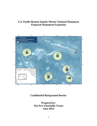
  • 1. 1 U.S. Pacific Remote Islands Marine National Monument Proposed Monument Expansion Confidential Background Dossier Prepared by: The Pew Charitable Trusts June 2014
  • 2. 2 Table of Contents Proposed Expansion of U.S. Remote Islands Marine National Monument..................................................3 2009 Declaration of U.S. Pacific Remote Islands Marine National Monument...........................................3 Monument Size.............................................................................................................................................4 Unique Ecology, Biodiversity and History...................................................................................................7 Seamounts.....................................................................................................................................................7 Ecological Connectivity between Atolls.......................................................................................................9 Kingman and Palmyra.................................................................................................................................11 Wake ...........................................................................................................................................................11 Johnston ......................................................................................................................................................12 Howland, Baker, and Jarvis ........................................................................................................................12 Tuna fisheries and bycatch..........................................................................................................................13 Economic and scientific rationale...............................................................................................................16
  • 3. 3 Proposed Expansion of U.S. Remote Islands Marine National Monument The Pacific Remote Islands Marine National Monument currently covers 212,714 square kilometers (82,129 square miles) encompassing seven islands and atolls in the central Pacific Ocean, including Wake, Johnston, Howland and Baker, Kingman and Palmyra, and Jarvis.1 2 Of these, Howland, Baker, and Jarvis Islands; Palmyra Atoll; and Kingman Reef, including their terrestrial areas, reef, and waters out to 12 nm, are part of the National Wildlife Refuge System. Johnston Atoll and Wake Island and their waters out to 12 nm are also part of the National Wildlife Refuge System. The Department of Defense manages “emergent lands.” A recent article published in Nature concluded that MPA effectiveness was strongly associated with several key variables including size and isolation, among others.3 These seven atolls and islands are farther from human population centers than any other U.S. area, and extending the National Marine Monument designation to 200 nautical miles could safeguard one of the last remaining pristine areas in U.S. waters from future exploitation. 2009 Declaration of U.S. Pacific Remote Islands Marine National Monument Through the use of the Antiquities Act, President George W. Bush was able to set these areas aside under federal jurisdiction for “the protection of objects of historic and scientific interest.” According to the proclamation, “the monument includes the waters and submerged and emergent lands of the Pacific Remote Islands to the lines of latitude and longitude depicted on the accompanying maps, which lie approximately 50 nautical miles from the mean low water lines of Wake, Baker, Howland, and Jarvis Islands, Johnston Atoll, Kingman Reef, and Palmyra Atoll.”4 The U.S. Fish and Wildlife Service (USFWS) currently manages from the mean low water line out to 12 nm, while the National Oceanic and Atmospheric Administration (NOAA) Fisheries manages fishing- related activities from 12-50 nautical miles. It is possible to expand the monuments outward from the current area of about 50 nautical miles around each atoll and island to 200 nautical miles, the full expanse of the U.S jurisdiction surrounding each atoll.5 Commercial fishing is prohibited throughout the existing designated areas. Subject to USFWS authority, non-commercial fishing may be allowed in consultation with NOAA Fisheries and the Western Pacific Fishery Management Council (WPFMC). Recreational fishing is restricted to specific locations in accordance with the proclamation. 6 From 50 to 200 nm (outside of the national marine monument boundary), WPFMC manages fishery resources through the “Fishery Ecosystem Plan for the Pacific Remote Islands Areas” and the “Pacific Pelagic Fishery Ecosystem Plan.” Currently, there is little fishing except for tuna fishing. 1 http://www.fpir.noaa.gov/MNM/mnm_prias.html 2 http://marineprotectedareas.noaa.gov/dataanalysis/mpainventory/mpaviewer/ 3 Edgar, G. et al. Global conservation outcomes depend on marine protected areas with five key features. Nature 506, 216–220 (2014 4 http://www.fws.gov/pacificremoteislandsmarinemonument/PP%20PRIMNM.pdf 5 http://www.fws.gov/pacificremoteislandsmarinemonument/PRIMNM%20brief.pdf 6 http://www.fws.gov/pacificremoteislandsmarinemonument/PP%20PRIMNM.pdf
  • 4. 4 Monument Size The 5 atoll groups that make up the Pacific Remote Islands Marine National Monument currently cover an area approximately 212,714 km2 spread over a wide swath of the Pacific Ocean. Expanding the Pacific Remote Islands Marine National Monument to the full 200 nautical miles exclusive economic zone boundary would increase the size of the area encompassed within no-take marine reserves by more than 1,700,000 km2 . These five areas together would create a series of protected areas totaling more than two million square kilometers. Chart 1: Atoll group size Site Name Area of Existing Monuments in square kilometers Area of Monument expansions in square kilometer(total, includes existing monument area) Wake Island 39069 433398 Jarvis Island 35486 318109 Howland Island and Baker Island 51896 437102 Palmyra Atoll 54050 350498 Johnston Atoll 39871 464013 TOTALS 220372 2003120 AREA ADDED (TOTAL - EXISTING) = 1782748 The first chart below compares the current Pacific Remote Islands Marine National Monument with other no-take areas around the world (comparisons are included for the both the aggregated total as well as the individual atolls.) Currently the individual sites rank as 8th , 9th , 11th , 12th , and 13th in size. The second chart shows where these areas would rank if expanded to the full 200 nautical mile border. The individual atolls would rank 3rd , 4th , 5th , 7th , and 8th in largest no-take areas globally.
  • 5. 5 Chart 2: Current rankings of large, no-take reserves. Marine Reserve Size (sq km) Percent No-Take No-Take Size (sq km) Chagos 640,000 100 640,000 Coral Sea 501,723 100 501,723 Papahanaumokuakea 363,000 100 363,000 Motu Motrio Hiva 150,000 100 150,000 Great Barrier Reef 344,000 34 124,000 South Orkney Islands 94,000 100 94,000 Macquarie Island 162,000 36 58,300 Kingman and Palmyra 54,021 100 54,021 Howland and Baker 53,270 100 53,270 Marianas Trench 246,000 17 42,000 Wake 36,762 100 36,762 Johnston 36,059 100 36,059 Jarvis 35,784 100 35,784 Rose Atoll 34,000 100 34,000 Phoenix Island (Kiribati) 410,000 3.7 15,000 Chart 3: Rankings of no-take reserves if Pacific Remote Islands Marine Monument is expanded Marine Reserve Size (sq km) Percent No-Take No-Take Size (sq km) Chagos 640,000 100 640,000 Coral Sea 501,723 100 501,723 Johnston 442,635 100 442,635 Howland and Baker 434,921 100 434,921 Wake 407,241 100 407,241 Papahanaumokuakea 363,000 100 363,000 Kingman and Palmyra 352,300 100 352,300 Jarvis 316,665 100 316,665 Motu Motrio Hiva 150,000 100 150,000 Great Barrier Reef 344,000 34 124,000 South Orkney Islands 94,000 100 94,000 Macquarie Island 162,000 36 58,300 Marianas Trench 246,000 17 42,000 Rose Atoll 34,000 100 34,000 Phoenix Island (Kiribati) 410,000 3.7 15,000
  • 6. 6 Chart 4: Overview of EEZ size and marine reserves by country. Country Marine Protections Australia • Australia has the 3rd largest EEZ and has protected 8% as no-take marine reserves. • Coral Sea Marine Reserve: 501,723 sq km; 100% no-take • Great Barrier Reef Marine Park: 344,000 sq km; 34% no-take • Macquarie Island Marine Reserve: 162,000 sq km; 36% no-take Chile • Chile has the 11th largest EEZ and has protected 4% as no-take marine reserves. • Motu Motrio Hiva Marine Park: 150,000 sq km; 100% no take Palau • In February of this year, Palau’s President, Tommy Remengesau announced his intent to close his EEZ to industrial scale fishing and create a marine sanctuary. • Palau is an important partner to the United States. • The Pivot to the Pacific is about global security and protecting Palau’s rich marine diversity helps increase resilience to climate change. • Once finalized Palau will protect up to 80% of its EEZ as a no-take marine sanctuary. • No other country in the world has protected this much ocean--President Remengesau should be commended for his conservation leadership Kiribati • When Kiribati announces that commercial fishing will cease in the Phoenix Islands it will have protected nearly 12% of its EEZ. • Phoenix Islands Protected Area is currently on 3.7% no-take or 15,000 sq km • Once fully protected the Phoenix Islands area will be one of the largest no- take reserves in the world at 410,000 sq km. United Kingdom • In 2010, the U.K. created the largest no-take marine reserve in the world in the Indian Ocean. • With the 5th largest EEZ in the world the U.K. has protected nearly 11% of its EEZ. • Chagos Marine Reserve: 640,000 sq km; 100% no-take • South Orkney Islands Marine Protected Area: 94,000 sq km; 100% no-take United States • The U.S. has the largest EEZ in the world and we currently protect less than 6% in no-take marine reserves. By expanding the Pacific Remote Islands National Monument to the full potential of the atolls we are adding nearly 1.8 million square kilometers of fully protected reserves to the world’s oceans. This is an area greater than the size of Alaska and nearly doubles the amount of ocean ecosystems currently protected as no-take reserves. • Papahanaumokuakea Marine Monument: 363,000sq km; 100% no-take • Marianas Trench Marine Monument: 246,000 sq km; 17% no-take • Rose Atoll Marine Monument: 34,000sq km; 100% no-take • Remote Pacific Islands Marine Monument: 220,732 sq km; 100% no-take • Expanded Remote Pacific Islands Marine Monument: 2,003,120 sq km; 100% no-take
  • 7. 7 Unique Ecology, Biodiversity and History “Deep coral forests occur below photic zones of all three islands at depths below 200 meters, especially at Jarvis where surveys have revealed living colonies of precious and ancient gold coral up to 5,000 years old.”7 The waters surrounding Baker, Howland, and Jarvis Islands have fish biomass double that of the Papahanaumokuakea Marine National Monument, and 16 times that of the main Hawaiian Islands, due to the Equatorial Undercurrent that moves from west to east along the equator, creating localized nutrient- rich upwellings in the shallows next to the islands. These are three of only six islands in the entire Pacific Ocean where this phenomenon is possible.8 The reefs at Kingman and Palmyra have set a new ecological baseline for coral reefs, and they changed what we expect reefs to look like. “Kingman Reef has the greatest known fish biomass and proportion of apex predators of any coral reef ecosystem that has been scientifically studied in the world.”9 Kingman is also one of the world's most pristine coral reefs, and should serve as a baseline for future studies of coral reef microbes.10 Kingman and Palmyra have shown that there is a direct relationship between fishing and coral disease.11 Johnston Atoll has shown low levels of coral disease, which provides an important baseline, especially in relation to climate change. With marine protected areas, differences in fish-assemblage structure have been observed between fished and unfished atolls in the northern Line Islands of the central Pacific. “Fish assemblages at Palmyra and especially Kingman atolls were characterized by high total standing biomass, large average body sizes, a preponderance of apex predators and other piscivorous fishes in an inverted biomass pyramid, few and small planktivorous fishes, and herbivores dominated by non-territorial species.”12 By comparing uninhabited areas to human-impacted areas within the Pacific, one study was able to re- create missing population baselines for Pacific reef sharks and found that reef shark populations increased when human population decreased.13 Historically, Wake, Johnston, and Howland witnessed fighting during WWII. In the late 1800s, the Howland, a whaling ship, wrecked at Johnston Atoll. Amelia Earhart was flying to Howland when her plane was lost. Seamounts In the total proposed expanded area for protection in the EEZs around these five islands, there are approximately 251 seamounts,14 which are underwater mountains, rising 1,000 meters or higher from the seabed without breaking the ocean's surface. The vast majority of these seamounts are virtually unexplored, supporting biodiversity-rich communities that are some of the most poorly understood in the 7 http://www.fws.gov/pacificremoteislandsmarinemonument/PP%20PRIMNM.pdf 8 http://www.fws.gov/pacificremoteislandsmarinemonument/PP%20PRIMNM.pdf 9 Federal register, Vol. 76, No. 65/Tuesday April 5, 2011 10 Microbial Ecology of Four Coral Atolls in the Northern Line Islands, http://scrippsscholars.ucsd.edu/ssandin/content/microbial-ecology-four-coral-atolls-northern-line-islands-1 11 http://www.asmcue.org/documents/Rohwer-ASMCUE-Corals5-19-10.pdf 12 http://scrippsscholars.ucsd.edu/ssandin/content/differences-fish-assemblage-structure-between-fished-and- unfished-atolls-northern-line-islan 13 http://onlinelibrary.wiley.com/doi/10.1111/j.1523-1739.2012.01835.x/abstract 14 http://seaaroundus.org/ecosystemsmaps/default.aspx
  • 8. 8 world.15 Every research expedition in these waters discovers large numbers of new species,16 such as previously unrecorded species of deep-water algae, coral, and fish.17 Chart 5: Seamount located in PRIA. Site Name Seamount counts in existing monuments Seamount counts in Monument expansion areas (total, includes existing area) Wake Island 8 40 Jarvis Island 4 24 Howland Island and Baker Island 5 21 Palmyra Atoll 26 68 Johnston Atoll 10 98 TOTALS 53 251 Scientists estimate that there are as many as 10 million species inhabiting the deep sea-- biodiversity comparable to the world's richest tropical rainforests. Deep-sea species tend to be slow growing, late maturing and endemic, making them particularly vulnerable to extinction.18 Much of the biodiversity in the deep sea is concentrated around seamounts. They are home to cold-water coral reefs and forests, sponge beds, and hydrothermal vents, as well as large marine mammals, such as dolphins and whales, and an extraordinary diversity of fish, creating one of the world’s greatest marine-biological treasures.19 The relatively few number of studies conducted in these waters have observed a total of 506 shore-fish species, and 27 epipelagic species have been recorded from these five islands.20 These waters also support many marine mammals, including sei whales, sperm whales, striped dolphins, false killer whales, melon- headed whales, and spotted dolphins, frequent populations of minke and humpback whales.21 According to the Fish and Wildlife Service, “these areas represent the last refugia for fish and wildlife species rapidly vanishing from the remainder of the planet, including sea turtles, dolphins, whales, pearl oysters, giant clams, coconut crabs, large groupers, sharks, humphead wrasses, and humphead parrotfishes. Fish biomass at these islands is remarkable.”22 These remote underwater “islands” provide an important source of food due to their nutrient upwellings and strong localized currents, which attract massive quantities of plankton. At the base of the food web, 15 Mundy et al, 2010, http://www.pifsc.noaa.gov/library/pubs/Mundy_etal_ARB_585_2010.pdf 16 Parrish and Baco, 2006, http://www.coris.noaa.gov/activities/deepcoral_rpt/Chapter4_HawaiiPacific.pdf 17 http://www.papahanaumokuakea.gov/research/biogeographic_cruise2013.html 18 Deep Sea Conservation Coalition, http://savethehighseas.org/deepsea/ 19 Ibid. 20 Mundy, et al, 2010, http://www.pifsc.noaa.gov/library/pubs/Mundy_etal_ARB_585_2010.pdf 21 http://www.pifsc.noaa.gov/qrb/2010_06/article_12.php 22 http://www.fws.gov/pacificremoteislandsmarinemonument/PRIMNM%20brief.pdf
  • 9. 9 these plankton hotspots are prime deep-sea feeding and spawning grounds, providing a pit stop for various pelagic species as they migrate through the vast open ocean.23 The deep sea is also home to remarkably rich coral systems. While more is known about shallow coral ecosystems, it is now thought that there are more coral species living at great ocean depths than in tropical shallows. These ancient corals, some as old as 8,000 years, create ornate, forest-like structures that would take hundreds of years to recover if disturbed by fishing activities such as bottom-trawling.24 These species rich waters host expansive shallow coral reefs and deep coral forests; the oldest corals observed in these deep waters are up to 5,000 years old.25 Ecological Connectivity between Atolls This collection of interconnected refuges serves as “key stepping stones for the colonization and dispersal of species between the eastern and western, and the northern and southern Pacific Ocean. Some of these refuges are also unique in that they benefit from localized upwelling from the Equatorial Undercurrent, 23 Ibid. 24 http://www.pewenvironment.org/campaigns/protecting-the-deep-sea/id/8589940401 25 http://www.fws.gov/pacificremoteislandsmarinemonument/PRIMNM%20brief.pdf
  • 10. 10 and others serve as destinations for additional species transported from the western Pacific by the Equatorial Countercurrent.”26 Palmyra Atoll lies within the inter-tropical convergence zone and path of the eastward moving Equatorial Countercurrent, which bring larvae of additional reef species from the more diverse West Pacific.27 The deep-sea Equatorial Undercurrent moves from west to east around these atolls and underwater seamounts, creating localized nutrient-rich upwellings in shallows next to the islands. In the entire Pacific Ocean, this only occurs in six islands (three of which are here).28 The Pacific is composed of two large gyres, the northern and southern central gyres; the complex interactions of these undercurrents contribute to overall connectivity of the deep-sea ecosystems, providing long-distance dispersal of pelagic larvae. The Pacific Equatorial Undercurrent moves at depths of 70–200 m, is approximately 450 km wide, and flows with velocities of up to 5 km/hour for a distance of up to 13,000 km. Jarvis, Howland, and Baker are in the equatorial system; Kingman and Palmyra are in the equatorial/eastern Pacific current; Hawaii, Wake and Johnston are in the center of the North Pacific gyre.29 26 Ibid 27 http://mcbi.marine-conservation.org/what/what_pdfs/Palmyra_Factsheet.pdf 28 1566 Federal Register / Vol. 74, No. 7 / Monday, January 12, 2009 Presidential Documents, http://www.fpir.noaa.gov/Library/MNM/Proclamation%208336%20-%20PRIA.pdf 29 Parrish and Baco, 2006, http://www.coris.noaa.gov/activities/deepcoral_rpt/Chapter4_HawaiiPacific.pdf
  • 11. 11 Kingman and Palmyra The waters surrounding Kingman and Palmyra comprise one of the world’s last intact coral reef ecosystems, and its species-rich waters have a higher proportion of apex predators than any other coral reef ecosystem in the world.30 The Kingman and Palmyra reefs support three times the number of coral species found in Hawaii and the Caribbean, and five times the number of species found in the Florida Keys. 31 “Palmyra's reefs look substantially different from all others in the equatorial Pacific, containing food webs dominated by an abundance of top predators, such as sharks, which have rapidly declined elsewhere. Indeed, sharks are commonplace at Palmyra. Their presence is a sign of overall reef ecosystem health and a key reason why the atoll is one of the few places in the world where they can be studied in natural numbers across their habitat range.”32 Palmyra's waters are teeming with species, including “manta rays, mullets, fusiliers, snappers, green and hawksbill turtles, humphead parrotfish, pilot whales, humphead wrasses, sharks, other rays, jacks, goat- fish, tuna, butterflyfish, damselfish, surgeonfish, rare giant clams, black-lipped pearl shells, and pen shells.”33 Pacific bottle-nosed dolphins, spinner dolphins, and melon-headed whales frequent the waters of the Refuge, in addition to stony corals.34 Palmyra also supports an array of invertebrates, including 176 stony coral species, 17 benthic cnidarian species, 12 species of macro-invertebrates.35 Palmyra also has 29 bird species including the bristle thighed curlew.36 As one of the world’s healthiest coral ecosystems, Palmyra provides a natural laboratory for studying the impact of climate change on coral reefs. Wake Because access is restricted around Wake, there has been little pressure from the fishing industry and marine biomass and biodiversity is likely to be extremely high.37 At least 323 species of fish and approximately 100 species of coral have been reported at Wake Atoll. These waters provide refuge for many species, which are depleted globally, including several species of sharks and abundant populations of the Napoleon wrasse.38 Large schools of humphead parrotfish comprise well over half of the total fish biomass.39 Foraging populations of green turtle (listed as threatened by the Endangered Species Act), as 30 http://www.nature.org/ourinitiatives/regions/northamerica/unitedstates/hawaii/palmyraatoll/explore/expeditio n-to-palmyra.xml 31 ibid 32 ibid 33 ibid 34 http://www.fws.gov/refuge/Palmyra_Atoll/wildlife_and_habitat/index.html 35 http://mcbi.marine-conservation.org/what/what_pdfs/Palmyra_Factsheet.pdf 36 http://www.fws.gov/refuges/profiles/index.cfm?id=12533 37 http://mcbi.marine-conservation.org/what/what_pdfs/Wake_Factsheet.pdf 38 http://www.fws.gov/refuge/Wake_Atoll/wildlife_and_habitat/index.html 39 NOAA 2009, http://www.pifsc.noaa.gov/qrb/2009_08/article_01.php
  • 12. 12 well as resident populations of spinner dolphins are common.40 Five species of coral found at Wake Atoll are listed as Vulnerable on the IUCN Red List of Threatened Species (Acropora aculeus, A. acuminata, A. palmerae, Montipora lobulata, and Pocillopora elegans).41 Wake Atoll hosts a healthy reef ecosystem of mostly hard (scleractinian) corals. In shallower reef areas, macroalgae are abundant.42 Abundant reef fish at Wake play the crucial role of grazers, regulating algal growth and enhancing overall coral reef health.43 The rare giant clam thrives here on shallow coral reefs.44 Johnston More than 300 species of fish have been recorded near the reefs of Johnston Atoll. Other species often found include the green turtle, reef sharks the Hawaiian monk seal, and humpback whales.45 Fifty-four species of corals have been reported at Johnston including 49 stony coral species. It supports 54 coral species, including a thriving table coral community and a dozen species found only in the Hawaiian and northern Line Islands.46 The most conspicuous species is the giant table coral (Acropora cytherea), which grows in large horizontal plates.47 The surface of the coral is covered by a thin layer of tissue containing a photosynthetic algae zooxanthella which provides energy for the coral.48 Johnston Atoll is the sole coral dispersal “stepping stone” into Hawaii.49 Coral spawn in Johnston Atoll is dispersed to the Hawaiian Islands.50 Expanding the monuments could help maintain these coral spawning pathways. Howland, Baker, and Jarvis “The waters surrounding Baker, Howland, and Jarvis Islands have fish biomass double that of the Papahanaumokuakea Marine National Monument and 16 times that of the main Hawaiian Islands.”51 “Coral cover and biodiversity is much higher compared to Hawaii and Florida. Beyond the shallow fringing reefs and terraces, the slopes of the extinct volcanoes drop off sharply to the deep floor of the equatorial Pacific Ocean. The Equatorial Undercurrent creates a localized nutrient-rich upwelling in the shallows near the islands, resulting in high fish biomasses and a high proportion of top predators. Up to 340 fish species inhabit these isolated reefs, and giant clams, sharks, and sea turtles are abundant.”52 40 http://www.fws.gov/refuge/Wake_Atoll/wildlife_and_habitat/index.html 41 Kenyon et al, NOAA 2013, http://www.pifsc.noaa.gov/library/pubs/Kenyon_etal_ARB_2013_600.pdf 42 NOAA 2009, http://www.pifsc.noaa.gov/qrb/2009_08/article_01.php 43 Kenyon et al, NOAA 2013, http://www.pifsc.noaa.gov/library/pubs/Kenyon_etal_ARB_2013_600.pdf 44 http://www.fws.gov/pacificremoteislandsmarinemonument/PRIMNM%20brief.pdf 45 http://www.fws.gov/refuge/Johnston_Atoll/wildlife_and_habitat/index.html 46 http://www.fws.gov/pacificremoteislandsmarinemonument/PRIMNM%20brief.pdf 47 http://www.fws.gov/refuge/Johnston_Atoll/wildlife_and_habitat/index.html 48 World Register of Marine Species, http://www.marinespecies.org/aphia.php?p=taxdetails&id=207095 49 http://onlinelibrary.wiley.com/doi/10.1111/geb.12101/abstract 50 http://www.denix.osd.mil/nr/crid/Coral_Reef_Iniative_Database/Johnston_Atoll_files/Kobayashi,%202006.pdf 51 1566 Federal Register / Vol. 74, No. 7 / Monday, January 12, 2009 Presidential Documents, http://www.fpir.noaa.gov/Library/MNM/Proclamation%208336%20-%20PRIA.pdf 52 http://www.fws.gov/pacificremoteislandsmarinemonument/PRIMNM%20brief.pdf
  • 13. 13 Tuna fisheries and bycatch There is little fishing within the United States Pacific Remote Island Areas (PRIAs), made up of Wake, Baker, Howland, and Jarvis Islands, Johnston Atoll, Kingman Reef, and Palmyra Atoll, with the exception of seasonal, but minimal, fishing by US commercial longline and purse seine tuna vessels. The tuna caught within these areas represents between 1 and 3 percent of the US tuna catch in the western and central Pacific. The US operates one of the world’s largest purse seine fleets in the Pacific Ocean, catching more than 230,000 metric tons of tuna from the western and central Pacific every year valued at more than $500 million53 . The US has 40 large scale purse seine vessels, which primarily fish in the exclusive economic zones (EEZs) of Pacific Island countries, including Kiribati, Papua New Guinea, and the Marshall Islands. Occasionally, US purse seiners set their nets in one of the EEZs of the US PRIAs, but no other fleets are permitted to fish in these areas. Tuna purse seine catch in PRIA EEZs averaged 1,047 metric tons annually from 2008-201154 , worth an average of $1.4 million per year.55 This represents less than 1 percent of the total US purse seine tuna catch in the western and central Pacific Ocean. US longline vessels also fish in the EEZs of Palmyra and Johnston Atoll, with effort averaging 3 percent of western Pacific longline activity from 2008-2011.56 All longline vessels with Hawaii or American Samoa limited entry longline permits are allowed to fish in the PRIA.57 In 2012, Hawaii’s longline fleet landed $95 million worth of fish, 58 $4.9 million of which was caught in the PRIA.59 Seventy-seven longline vessels fished in the PRIA (out of 129), making 130 trips (9% of all longline trips), 766 sets (4% of all longline sets), and 1.9 million hooks (4% of total hooks by the fleet).60 Of note, should these areas be closed to fishing, because the U.S. 53 Value of Western and Central Pacific Tuna Fisheries. Forum Fisheries Agency 2013. http://www.ffa.int/node/425#attachments 54 Ibid 55 Ibid 56 Pelagic Fisheries of the Western Pacific Region 2011 Annual Report. Western Pacific Regional Fishery Management http://wpcouncil.org/wp- content/uploads/Large%20PDFs/2011%20Pelagics%20Annual%20Report_Final.pdf 57 Western Pacific General Longline Fishing. NOAA Fisheries Service. http://www.fpir.noaa.gov/SFD/pdfs/Reg%20Summary%20WP%20General%20Longline%20(rev.%207-23-10).pdf 58 Table 9: Hawaii commercial pelagic landings, revenue, and average price by species for the Hawaii-based deep- set and shallow-set longline fisheries, 2011-2012.Page 83. http://www.wpcouncil.org/wp- content/uploads/2013/03/BD46_Territory_Limits_FEP_Amd_7___FINAL_transmitted_draft_2013-23-12.pdf 59 Calculated using Table 10: Hawaii commercial pelagic landings, revernue, and average price per pound by fishery, 2011-2012. Page 83. http://www.wpcouncil.org/wp- content/uploads/2013/03/BD46_Territory_Limits_FEP_Amd_7___FINAL_transmitted_draft_2013-23-12.pdf, and the Hawaii-based Longline Logbook Summary Report 2012. http://www.pifsc.noaa.gov/library/pubs/DR-13- 004.pdf 60 The Hawaii-Based Longline Logbook Summary Report 2012. Pacific Islands Fisheries Science Center. http://www.pifsc.noaa.gov/library/pubs/DR-13-004.pdf 99% 1% United States Pacific Tuna Purse Seine Catch 233,331 Metric Ton Average Catch US purse seine tuna catch outside PRIA US purse seine catch in PRIA
  • 14. 14 can fish on the high seas and in the Hawaii EEZ, their overall catch levels would not be impacted. Both purse seine and longline fisheries in the PRIAs have significant bycatch concerns. By number, shark bycatch made up 11 percent of total catches from the longline fishery in the PRIA in 2012, including catches of threatened silky and oceanic whitetip sharks.61 Billfish caught as bycatch in the longline fishery, including the overfished striped marlin, made up 4.7 percent of the longline catch in the PRIA.62 Purse seiners catch threatened shark species as well as high volumes of juvenile bigeye tuna which are experiencing overfishing throughout the region. The EEZs of the PRIAs contain higher concentrations of juvenile bigeye than any other area in the western and central Pacific Ocean.63 During El Nino events, there is increased fishing in the Pacific Remote Islands Areas because tuna populations in the western Pacific migrate east. The last strong El Nino event occurred in 1997-1998, during which time the U.S. purse seine vessel catch in PRIAs significantly increased.64 Between 2008- 2011, however, the annual value of the U.S. purse seine fleet catch in the Pacific Remote Islands area ranged from $655,000 to 3.0 million65 . Of note is that should these areas be closed to fishing, because of the U.S. Tuna Treaty, these vessels can continue to fish in the entire area outside of the Remote Pacific Island waters without diminishing the total amount of fish that they could catch. 61 http://www.pifsc.noaa.gov/library/pubs/DR-13-004.pdf 62 ibid 63 http://www.spc.int/DigitalLibrary/Doc/FAME/Meetings/WCPFC/SC6/ST-IP-02.pdf 64 http://www.wpcouncil.org/documents/value.pdf 65 Value of Western and Central Pacific Tuna Fisheries. Forum Fisheries Agency 2013. http://www.ffa.int/node/425#attachments
  • 15. 15 Bottom fisheries may also operate in the PRIA. According to the WPFMC FEP, “while there are currently no known bottom fish (e.g., snapper, groupers, jacks) fisheries operating in the PRIA, several vessels have been known to occasionally fish for bottom fish in federal waters around PRIA.”66 Bottom fisheries 66 http://wpcouncil.org/fep/WPRFMC%20PRIA%20FEP%20(2009-09-21).pdf, p. 82
  • 16. 16 using trawls or bottom gillnets have been internationally recognized as highly destructive, particularly to vulnerable deep-sea ecosystems around seamounts. Economic and scientific rationale Large marine protected areas (LMPAs) are more cost-effective than smaller areas. When maintenance costs of 83 marine protected areas (MPAs) were examined, it was found that annual maintenance costs were “significantly more prohibitive when MPAs were smaller, located in coastal areas and located in developed countries.”67 Another study examining Australia’s Coral Sea found that managing the LMPA as a 100 percent no-take area was between 1.3 and 2 times more cost-effective than managing it as a multiple-use area with only 30 percent designated as a no-take area.68 Marine reserves may also increase resilience of nearby fisheries and serve to provide insurance for uncertainty in the environment, markets, or fisheries management strategies.69 A recent article published in Nature concluded that MPA effectiveness was strongly associated with five key variables: 1) fishing intensity, 2) enforcement, 3) age, 4) size, and 5) isolation70 The expansion of these monuments would have a good chance of being effective: the areas would be no- take; the US has the capacity to monitor and enforce the areas; if expanded all atoll sites will be greater than 300,000 square kilometers; and the atolls are isolated. Other studies on MPAs have found: • Large MPAs have the potential to protect highly mobile species, such as sharks and tuna71 • Larger MPAs can enhance fish biomass by reducing MPA edge, which in turn improves reseeding72 • Large MPAs can serve as reference sites for documenting changes from global threats, such as climate change and ocean acidification73 67 Balmford, A., P. Gravestock, N. Hockley, C. J. McClean, and C. M. Roberts. 2004. The worldwide costs of marine protected areas. Proceedings of the National Academy of Sciences of the United States of America 101:9694–9697. 68 Ban, N. C., V. Adams, R. L. Pressey, and J. Hicks. 2011. Promise and problems for estimating management costs of marine protected areas. Conservation Letters 4:241–252. 69 Grafton RQ, Kompas T (2005) Uncertainty and the active adaptive management of marine reserves. Mar Policy 29: 471–479. 70 Edgar, G. et al. Global conservation outcomes depend on marine protected areas with five key features. Nature 506, 216–220 (2014). 71 Koldewey, H. J., D. Curnick, S. Harding, L. R. Harrison, and M. Gollock. 2010. Potential benefits to fisheries and biodiversity of the Chagos Archipelago/British Indian Ocean Territory as a no-take marine reserve. Marine Pollution Bulletin 60:1906–15. 72 Walters, C. 2000. Impacts of Dispersal, Ecological Interactions, and Fishing Effort Dynamics on Efficacy of Marine Protected Areas: How large should protected areas be? Bulletin of Marine Science 66:745–757. 73 Selkoe, K. A., B. S. Halpern, C. M. Ebert, E. C. Franklin, E. R. Selig, K. S. Casey, J. Bruno, and R. J. Toonen. 2009. A map of human impacts to a “pristine” coral reef ecosystem, the Papahānaumokuākea Marine National Monument. Coral Reefs 28:635–650.