SlideShare une entreprise Scribd logo
1  sur  19
Télécharger pour lire hors ligne
DEPARTMENT OF PLANNING, BUILDING & ZONING
                                          111 West Fox Street • Room 316
                                               Yorkville, IL • 60560
                                   (630) 553-4141             Fax (630) 553-4179
                                         04-40 – Prairie Material Sales, Inc. et al
                                              Map Amendment A-1 to M-3
                                                           Hearing # TBD

SITE INFORMATION

           PETITIONERS    New Lenox State Bank, Trustee for Trust # 1291 – Prairie Material Sales, Inc
                          – Keith C. Hosbach and Wendy E. Hosbach
              ADDRESS     None assigned

              LOCATION    Sherrill Road west of Route 47

             TOWNSHIP     Lisbon

              PARCEL #    08-33-400-002; 08-33-400-004; 08-33-400-005

                   SIZE   120.10 acres

     EXITING LAND USE     Agricultural

                ZONING    A-1

                  LRMP    Agricultural

   REQUESTED ACTION       Map Amendment changing the zoning map for the subject parcel from A-1
                          (Agricultural) to M-3 (Earth Materials Extraction, Processing and Site
                          Reclamation)
             APPLICABLE   Section 10.03 of the Zoning Ordinance (M-3 Earth Materials Extraction,
           REGULATIONS    Processing and Site Reclamation)
                          Section 13.06 of the Zoning Ordinance (Amendments)

SURROUNDING LAND USE


  Location      Adjacent Land Use             Adjacent               LRMP            Zoning within
                                               Zoning                                    ½ Mile
   North            Agricultural                 A-1               Agricultural     A-1; B-3; M-1; M-
                                                                                             2

   South            Agricultural            Grundy County        Grundy County        Grundy County

    East            Agricultural                 A-1               Agricultural             A-1

   West             Agricultural                 A-1               Agricultural             A-1
Petition #   04-40 Sherrill Road west of Route 47(Prairie et al)                                           Page 2 of 19


REQUESTED ACTION
                 GENERAL       The petitioner, Prairie Material Sales, Inc., is requesting a Map Amendment changing
                               the zoning designation of approximately 120 acres in Lisbon Township from A-1
                               (Agricultural) to M-3 (Earth Materials Extraction, Processing and Site Reclamation).
                               The purpose of this request is to construct and operate a limestone quarry on the
                               site.

                               The M-3 designation was specifically written for this kind of use, as there are no other
                               zoning designations available for the proposed use. The M-3 is written as a specific,
                               rather than a general, zoning designation in that subsumed in the ordinance language
                               is a set of mandatory conditions that all applicants must follow. A copy of the M-3
                               language is included in the agenda packet. One of those conditions addresses the
                               issuance of a mine operations permit. See the staff analysis for the request for
                               further details.

                        NRI    Review of the NRI report, dated April 23, 2004, reveals the following:

                                    •    100% of the soils on the subject parcel are prime soils and the most
                                         agronomically productive.
                                    •    100% of the soils on the subject parcel are rated “severe” and have
                                         limitations for shallow excavations and local roads/streets.
                                    •    A wetland does exist on the subject parcel.

                      LESA          Land Evaluation: 93
                                    Site Assessment: 147
                                    TOTAL: 240
                                    LEVEL OF PROTECTION: High

                 FACTORS       The following factors are to be used by the Zoning Board of Appeals when
                               analyzing a map amendment request per Section 13.06.F of the Zoning
                               Ordinance:

                               EXISTING USES OF PROPERTY WITHIN THE GENERAL AREA
                               Existing land uses within 1 ½ miles of the subject parcel are depicted in Volume 1,
                               Exhibit 1 – Land Use Aerial. The subject parcel is currently being used for agricultural
                               purposes and all of the immediately abutting properties are in agricultural use.
                               Overall, 92.5% of the general area is presently in agricultural use.

                               The second most predominant land use in the general area is mineral extraction.
                               This includes the Valley Run Stone and Central Limestone quarries located within a
                               half mile and a mile northwest of the subject parcel.

                               Commercial land use in the general area is limited to the Hogan-Walker/John Deere
                               farm implement dealer located approximately ¼ mile southeast of the subject parcel.

                               Residential land use accounts for less than ½ of 1 % (0.5%) of the land usage in the
                               general area.

                               ZONING CLASSIFICATION OF PROPERTY WITHIN THE GENERAL AREA

                               Existing zoning classifications within 1 ½ miles of the subject parcel are depicted in
                               Volume 1, Exhibit 2 – Zoning Aerial. The subject parcel is currently zoned A-1
                               Agricultural and is used for agricultural purposes. All of the immediately adjacent
properties in Kendall County are zoned A-1 Agricultural and the adjacent properties
to the south are zoned A Agricultural by Grundy County.

Within the general area there is a variety of existing non-agricultural zoning districts
that incorporate mineral extraction either as a legal nonconforming use or as a result
of a court order. The Central Limestone quarry property is zoned M-2 Heavy
Industrial. Mineral extraction is no longer permitted in the M-2 zoning district, so the
Central Limestone quarry is operating as a legal nonconforming use. The Valley Run
quarry is operational due to issuance of a Kendall County Circuit Court order.

Overall, these existing operations account for 310 contiguous acres of land devoted
to mineral extraction in the general area.

The only other zoning classification in the general area is a small B-3 designation at
the northeast corner of Route 47 and White Willow Road.

SUITABILITY OF PROPERTY FOR USES PERMITTED UNDER THE EXISTING
ZONING
The subject parcel is zoned A-1 Agricultural, and is presently in row crop production.
The property is currently used for crop farming, a permitted A-1 use. The suitability of
the property for agricultural purposes is evidenced by the high LESA score of 240.
The subject parcel is not in the path of advancing nonagricultural development and is
surrounded by existing agricultural operations.

Suitability for Proposed Use: Certainly a major aspect of suitability is the capacity
and physical condition of the local road network to service the proposed use. The
applicant has provided a road improvement plan [Volume 1, Tab 11] to the County.
This report does not purport to say that this plan is adequate – only that the applicant
is aware that it will be an issue. The technical aspect of that plan will be addressed at
the mining operations permit stage.

Another aspect of suitability is the presence of wetlands on the parcel. Appropriate
steps need to be taken in order to protect the wetland. The applicant has provided a
plan to address wetland protection. This report does not purport to say that this plan
is adequate – only that the applicant is aware that will be an issue. The technical
aspect of that plan will be addressed at the mining operations permit stage.

Certainly, there needs to be evidence that there is aggregate to be extracted under
the subject property. The petitioner has performed borings that indicate the existence
of subsurface dolomite limestone.

TREND OF DEVELOPMENT IN THE AREA
The most prominent use changes that have occurred in the general area since the
subject parcel was zoned A-1 has been the readaptation of over 310 acres of land for
mineral extraction purposes. Otherwise, the trend of development has been generally
stable with agricultural uses dating back to the 19th Century.

CONSISTENCY WITH THE SPIRIT OF THE LAND RESOURCE MANAGEMENT
PLAN
It can be argued that the proposed use of the subject parcel is consistent with the
LRMP. The County’s objectives in the area of mineral extraction activities are as
follows:


                                                 G: /REPORTS/2004/04-40/PBZ 04-40 (04.28.05)
                                               Prepared by Dale R. Powers, AICP, Senior Planner
                                                                                  Page 3 of 19
•   “Identify and conserve areas of mineral resources to assure continued
        availability of building and engineering materials.”
    •   “Require the development of plans for the implementation of mine[s]...”
    •   “Protect prime mineral extraction areas from encroachment by incompatible
        uses.”
    •   “Protect other land uses from negative impacts of mineral extraction…
        through appropriate siting and adequate screening and buffering.”

These objectives anticipate the establishment of additional quarries in the County to
address the aggregate needs of the County. Location of these quarries, out of
necessity, is driven by the location of the deposits to be mined. According to the
submittal documents, an estimated 60,000,000 tons of dolomite limestone are
present under the subject parcel.

It can also be argued that the proposed use of the subject parcel is
inconsistent with the LRMP. Section 3.A.1 of the LRMP [p. 3-1] states the
following planning goals and objectives in the area of water:
    • “Maintain and enhance the chemical, physical and biological integrity
        of the county’s surface and ground waters.”
    • “Protect natural drainage areas, floodplains and wetlands to avoid
        costly man-made storm water projects and to protect associated
        habitats for both flora and fauna. Regulate development to insure that
        the quantity or rate of runoff does not increase from what currently
        occurs under natural conditions.”

Section 3.A.2 describes the County’s objectives under land use:

    •   “Prevent the disruption of the natural environment by allowing only
        those land developments and other human activities that exhibit
        sensitivity to the character and limitations of the natural environment.”

 Evidence in the record at this time indicates that an aquifer servicing the surrounding
 agricultural and residential uses will be invaded. The petitioner has submitted a plan
 to divert this water off the site via Valley Run Creek. However, the record does not
 indicate what the petitioner plans to do to mitigate the following environmental
 challenges:

    •  Dewatering: To the extent that this aquifer will be invaded, will this cause all
       of the water wells in the area to become dry? What is the geographical area
       of the impact?
   • Exposing surface waters to evaporation.
   • Potential of infiltration of pollutants into the water to be discharged.
Section 4.B describes the County’s objectives under regulatory techniques:

    •   “Evaluate the need and effectiveness of regulations based on the
        potential for improving Kendall County’s living, working and natural
        environments, not simply the protection of property value.”

As well, the Lisbon Township LRMP Summary states that mining activity “may
be permissible depending on the need for the product in the area and the
                                                 G: /REPORTS/2004/04-40/PBZ 04-40 (04.28.05)
                                               Prepared by Dale R. Powers, AICP, Senior Planner
                                                                                  Page 4 of 19
impact on the environment.”

   TOWNSHIP:      At its September 14, 2004 regular meeting, the Lisbon Township Board unanimously
                  ratified the recommendation of the Lisbon Township Plan Commission to deny
       (Lisbon)   approval of the map amendment request. Copies of the Minutes from that
                  meeting are included as an attachment to this report.
     (09.14.04)

ZPAC (07.06.04)   Highlights from the July 6, 2004 ZPAC meeting on this petition:

                      •   Fran Klaas stated that Sherrill Road would need perpetual care with traffic
                          coming in and out of the quarry.
                      •   Mike Waldron stated a concern about the potential impacts on Valley Run
                          Creek, specifically where detained water would enter the creek and the rate
                          of release.
                      •   Jason Pettit reiterated Waldron’s concerns and also included potential
                          impacts to the neighboring Aux Sable Creek on water quality and impacting
                          on fish in the creek.
                      •   Sheriff Richard Randall raised safety concerns for the 47-Sherrill Road
                          intersection, suggesting the installation of turn lanes and traffic lights there.

                  Attorney Robert Britz introduced his team of experts present at this meeting, ready
                  to answer questions if needed. He explained the operations of this proposed quarry
                  stating this was an ideal site for this type of operation. He spoke of the impact on the
                  neighboring area and addressed the issues of blasting, roadways, water, dust and
                  drainage. He spoke of property values and the effect of the economy this site would
                  promote. He feels they can put together a project that would be good for Kendall
                  County that would not be harmful to the neighboring properties.

                  Believing the quarry would affect this area, neighbor Arline Brue asked the board to
                  think about the future potential growth that would be impacted. She also spoke of the
                  traffic and safety concerns from Sherrill Road onto Route 47.

                  Neighbor Gary Anderson spoke of water concerns and the impact on the
                  surrounding wells.

                  Neighbor Henry Babson spoke of water concerns and with his involvement in Real
                  Estate, the negative impact on their property values.

                  In addition to the traffic, noise and dust, neighbor Robert Friestad spoke of his
                  concerns of water, flooding, high PH in the soil, and damage to the crops.

                  Neighbor Milford Bjelland spoke of his concerns of the dangerous truck traffic on
                  Route 47.

         KCRPC    Attorney Bob Britz, representing the petitioner, stated reasons that support the map
                  amendment request: rich mineral reserves, flat topography, distance from urban
     (09.29.04)   areas, lack of centralized water and sewer in the subject area, and accessibility to
                  main arterial roads and railroads. Britz further stated that with the development
                  pressures in the area that the need for aggregate will only increase.

                  Petitioner’s land planner and zoning consultant, Mike Donahue, stated an argument
                  for the “highest and best use” of the parcel as a mining operation and tied his
                                                                    G: /REPORTS/2004/04-40/PBZ 04-40 (04.28.05)
                                                                  Prepared by Dale R. Powers, AICP, Senior Planner
                                                                                                     Page 5 of 19
rationale to the LRMP language of “identifying, conserving and protecting” mineral
extraction areas.

Petitioner’s Geologic Site Appraiser, Arthur Pincomb, estimated that the estimated
reserves on the subject parcel are 40,000,000 tons of “high quality” aggregate
material with 15 feet of overburden [the amount of topsoil over the source], and
claims that there are no other deposits that meet “these” characteristics in the
Chicago area. Pincomb also expanded on Donahue’s “highest and best use” theory
by stating that, using the U. S. Department of Justice “Royalty Income Method” of
highest and best use, the land is worth $6,000 - $9,000 per acre as agricultural land
and $26,000 per acre if mining were authorized for the site.

Senior Planner Dale Powers emphasized to the group that it was the role of staff to
present both sides to the request and, since the petitioner stated the reasons for
granting the map amendment, he spoke of the rationale behind denying the map
amendment request. Powers stated that traffic and stormwater issues were two
important reasons to consider, and shared with the attendees that stormwater issues
had yet to be addressed by Strand Associates, the County’s consulting civil engineer.

RPC Secretary Larry Nelson reminded the assemblage of the care and extent in
which the County has addressed the Land Resource Management Plan, and stated
that the RPC has an important job in protecting the land uses in the County and to
consider the impact any one proposed use would have on surrounding areas.

Petitioner’s Traffic Engineer, Mike Werthmann, reported that Route 47 has the
capacity to accept the additional number of daily trips [120], and indicated that the
petitioner intends to improve Sherrill Road to a 40-ton standard from the mine
entrance east to Route 47 and to install acceleration/deceleration lanes on Route 47
in the vicinity of the proposed quarry.

PUBLIC COMMENTS: Ruth Bell (via letter) – traffic, water and berming issues. The
petitioner was forwarded a copy of the letter. Karen Kyrouac – concerns about the
impact of surrounding land values, and stated that agricultural property is worth
$30,000 per acre and half that if the quarry was allowed. Art Prochaska (Yorkville
Mayor) – submitted correspondence from City Attorney Roy Harsch asking for a
response to the City’s concerns over ground and surface water, underground
fractures, impact on adjacent water wells, impacts of the Aux Sable Creek, traffic,
and a comparison between IDOT’s traffic numbers and the petitioner’s traffic
numbers. Melissa Barnhart (attorney representing some adjacent property owners)
– wanted to clarify the zoning status of the other quarry operations, and reminded the
group that the two existing quarry operations never received County approval. The
“Shaw” quarry – Central Limestone – was in existence since before the County had
zoning regulations, and the “Avery” quarry – Valley Run – is operating under a court
order. Barnhart also questioned Pincomb’s statements as running contrary to
testimony from him 10 years ago in regards to the Piert farm. Rose Spears (Yorkville
Alderwoman) – traffic and public safety concerns. Scott Hoelscher (Northern
Pipeline) – impact of blasting on an existing 36-inch, 1000 pound natural gas line that
runs along the north edge of the subject property. Chairman Mohr asked that the
petitioner and Hoelscher meet to get this issue resolved. Bob Friestad – water and
traffic concerns. He shared a photo from a June 10 storm that created ponding, and
felt that the proposed berming would create “even more” of a water problem. Joe
Slivka (Lisbon Village Trustee) stated that negotiations are ongoing with Valley Run
to add 120 acres of quarry area, which will add to the water problem with Valley Run
                                                G: /REPORTS/2004/04-40/PBZ 04-40 (04.28.05)
                                              Prepared by Dale R. Powers, AICP, Senior Planner
                                                                                 Page 6 of 19
Creek. Keith Coppelman – inquired into Sunday operations (opposed).

             Summarizing the public comments, questions posed by RPC members to the
             petitioner’s centered around impact of land values, impact on the watershed in
             general, dolomite market value analysis, the Northern Pipeline issue, impacts on
             ground and surface water, location of the underground fractures, impact on adjacent
             water wells, and reclamation issues.

             The public meeting was recessed until 6:30 pm October 19, 2004.

   KCRPC     This is the continuation of the recessed public meeting from September 29,
             2004.
(10.19.04)
             In response to issues raised at the 09.29.04 public meeting, the RPC received
             information from the petitioner on the following issues:

             Fracture and Groundwater Study: At the 09.29.04 meeting, testimony revealed the
             potential of a major underground fracture on the site. The Petitioner stated that if the
             operation of the quarry would cause nearby water wells to dry up, the Petitioner will
             repair the problem by lowering the pump, deepening the well, or drilling a
             replacement well at no cost to the impacted well owner.

             Watershed Impact Study: At the 09.20.04 meeting, a concern was raised that surface
             water flows would be redistributed from one watershed to another, causing flooding
             problems to the nearby landowners. The petitioner stated that, in a meeting with
             Strand Associates, the proposed stormwater discharge plan was reviewed and that
             said plan met with the preliminary approval of Strand.

             Landscape Plan: At the 09.29.04 meeting, no detailed landscape plan was forwarded
             for review and comment. The petitioner acknowledges that the submitted landscape
             plan will need to be modified and the plan will be resubmitted upon application for a
             Mine Operations Permit.

             Pipeline: An engineer with Northern Pipeline will be in contact with the petitioner in
             order to coordinate this issue.

             Traffic Impact: The petitioner presented an analysis of this issue from Konig,
             Lindgren, et al. dated 10.13.04.

             Geographic Distribution of Dolomite Limestone: The petitioner presented an analysis
             of this issue from Associated Geologists, Inc. dated 10.14.04.

             Quarry Operations Impact on Subsequent Commercial Development: The petitioner
             presented aerial photography of the Vulcan McCool quarry that existed at the time of
             development of an adjacent shopping center, and stated that the shopping center
             currently has 100% occupancy.

             Hours of Operation: The petitioner stated that it would abide by the County’s
             ordinance that sets the hours of operation at 0600-1900 from 04.01 to 11.01 and
             0600-1800 from 11.02 to 03.31. Hours may be extended during a “public emergency”
             upon issuance of same by the County Highway Engineer.

             Staff presented correspondence from IDOT dated 03.16.04 that notified Aux Sable
                                                              G: /REPORTS/2004/04-40/PBZ 04-40 (04.28.05)
                                                            Prepared by Dale R. Powers, AICP, Senior Planner
                                                                                               Page 7 of 19
Stone Co. that its 2004 inspection passed, indicating their aggregate gradation limits
are acceptable and is classified as a “certified aggregate source” under IDOT’s
Aggregate Gradation Control System. This may refute the petitioner’s 09.29.04
claim that the Aux Sable quarry was not “IDOT quality” as required by IDOT for
being able to provide road making materials.

RPC Questions to the Petitioner: Larry Nelson asked how the proposed quarry
location received the quality and amount of limestone indicated in the Petitioner’s
study. Art Pincomb noted that this parcel has “Class A” material. Nelson responded
that the submitted maps may address the general location of dolomite limestone in
the Chicago area but they do not address the thickness of the high-quality dolomite
vs. the amount of “chert” [non-aggregate] or amount of [lower grade] “limestone”.

A discussion ensued between PBZ staff and the petitioner on the interpretation of
“highest and best use”. Petitioner’s Real Estate Appraiser Mike McCann presented a
land sales study for agricultural property alone Route 37 from I-80 in Morris, IL to the
Wisconsin border. RPC Chair Randy Mohr stated that the “highest and best use’ is
not always financially driven.

Annette Hattner questioned the direct economic impact of the quarry on tax receipts
such as property and sales tax. The petitioner responded that “99%” of the sales
would be to contractors and thus exempt from sales tax. [There was nothing in the
record as to the property tax question.]

PBZ Staff continues to have a concern about the proposed location atop a watershed
divide. Illinois drainage law prohibits cross-watershed water transfers.

Public Comments: Ralph LeGrand – traffic flow issues and stated that Historic
Route 66 near the McCook quarry was closed due to the damage caused by heavy
truck traffic. Petitioners Attorney Bob Britz responded that the laws have changed
and that the petitioner has an obligation to see that the roads are maintained. Karen
Kyrouac – restated her property value concerns. Henry Babson – quarry life cycle
issues. Melissa Barnhart – attorney representing several adjacent property owners
– pipeline safety issues. RPC Chair Randy Mohr asked the petitioner to get this
issue settled in writing prior to the 12.08.04 RPC meeting. Barnhart also asked if
there are any IDNR issues regarding the Boughton quarry. The petitioner responded
that there is a pending case but does not know the status of it. Bob Friestad – traffic
study of Joliet Road. Karla Stacy – traffic safety. Kris Swenson - farmland
preservation. Dick Wagner – “strategic planning specialist” – supported Ms.
Swenson’s comments and stated that the rich productive soils of this region need to
be kept in production.

Larry Nelson asked whether the site could be returned to productive farmland when
the soil has been stripped and the reserves depleted. Petitioner Robert Furlong
responded that this can be done and is being done in two other locations.

Annette Hattner asked whether the petitioner is making a financial commitment to
the road improvement to Sherrill Road and Route 47. The petitioner stated it is and
the estimated cost of the improvement is in the $250,000 - $500,000 range.


The public meeting was recessed until 6:30 pm December 8, 2004.

                                                 G: /REPORTS/2004/04-40/PBZ 04-40 (04.28.05)
                                               Prepared by Dale R. Powers, AICP, Senior Planner
                                                                                  Page 8 of 19
This is the continuation of the recessed public meeting from October 19, 2004.

   KCRPC     RPC Chairman Randy Mohr received correspondence dated 11.01.045 from Mike
             Sitterly, president of The Western Sand and Gravel Company of Spring Valley, IL –
(12.08.04)
             the company which operates the Aux Sable Stone Quarry. The letter disputes the
             testimony of Petitioner’s Geologic Site Appraiser Art Pincomb on the submitted
             market study and analysis of the quality of material produced at the Aux Sable
             quarry. This letter was entered into the record.

             In response, Pincomb stated that the Aux Sable quarry was included in the report as
             part of the market study that produced “a good quality of stone”. In response to Larry
             Nelson’s question about market competition, Pincomb stated that “with competition,
             costs could be controlled.”

             Claire Wilson asked the petitioner if they had reviewed the report from the County’s
             consulting geologic expert, Dr. William Lang, which raised questions regarding the
             geology of the area. Petitioner’s Civil Engineer, Gordon Stephens of Patrick
             Engineering, stated that he had read Dr. Lang’s report and that an “extensive”
             hydrogeologic study was performed and the study confirmed that the permeability of
             the site was consistent. Stephens also indicated that potential fracture areas were
             identified. The petitioner does not anticipate any impact to surrounding water wells
             but, if such an impact were to arise that the petitioner would cover the costs of
             restoring the water to the impacted wells.

             Correspondence was received from the City of Morris. The City states that
             commercial developers are attracted to the City by its centralized location 20 miles
             north of Dwight – 20 miles west of Joliet – 20 miles south of Yorkville – and 20 miles
             east of Ottawa. The City’s comprehensive land use plan called for Route 47 to be
             developed as a commercial corridor. The City’s planning area extends north to
             Minooka Road, 1 mile south of the subject site.

             Strand Associates outlined its engineering concerns and listed 14 items that are still
             outstanding as of this time. Strand’s primary concern is the proposed diversion of
             stormwater runoff across watershed divides. Jim Pore of Prairie Materials met with
             the adjoining neighbors and stated that the drainage design – which Pore said was
             similar to the drainage design at its Pontiac, IL facility – met with the approval of the
             neighbors.

             There being no further comments, Nelson/Ashton moved to approve Petition 04-
             40. The motion failed by a 1-9 vote, with all RPC members voted in the negative
             except for member Wilson. [NOTE: A copy of the minutes of the three RPC
             meetings is attached to this report.) The main reasons for the failure of the motion
             are as follows:

                 •   The petitioner did not establish the needs for the product as required in the
                     Land Resource Management Plan.
                 •   Faulting on the site presents a risk to groundwater supply.
                 •   The watershed issue is not being fully addressed.
                 •   Prime farmland should be protected.
                 •   The highest and best use of the land is agriculture.


                                                              G: /REPORTS/2004/04-40/PBZ 04-40 (04.28.05)
                                                            Prepared by Dale R. Powers, AICP, Senior Planner
                                                                                               Page 9 of 19
ZBA     After entering into the record Volumes 1-3 of the Application Submittals, the
             Addendum to the Submittals, the Preliminary Review of the Submittal documents by
(02.15.05)   Dr. William Lang, Ph. D., the County’s consulting geologic engineer, the decision in
             Peart et. al v. County of Kendall (93-MR-23, a/k/a the “Feltes” decision), the staff
             report prepared by PBZ staff, all minutes of the proceedings of the Lisbon Township
             Plan Commission and Lisbon Township Board, Kendall County Regional Planning
             Commission, and a publication called “Illinois Drainage Law” from the University of
             Illinois, State’s Attorney Tim McCann swore in all those who wished to testify at this
             public hearing.

             Refer to the unapproved minutes of this meeting, which are included as an
             attachment to this report. This portion of the public hearing consisted of the following:

                 1. The petitioners presented their case.
                 2. The petitioners responded to questions from ZBA members.

             Martin/McKay unanimous to recess the public hearing until March 1, 2005 at 6:30
             pm in the County Board Room.

     ZBA     Refer to the unapproved minutes of this meeting, which are included as an
             attachment to this report. This portion of the public hearing consisted of the following:
(03.01.05)
                 1. The petitioners responded to questions from ZBA members.
                 2. Cross-examination of the petitioners by attorney’s representing legal
                    objectors to the map amendment.

             Martin/Cryder unanimous to recess the public hearing until March 21, 2005 at 6:30
             pm in the County Board Room.

     ZBA     Refer to the unapproved minutes of this meeting, which are included as an
             attachment to this report. This portion of the public hearing consisted of the following:
(03.21.05)
                 1. Testimony from the public.
                 2. Testimony from Mike Waldron, P. E. of Strand Associates, the County’s
                    consulting civil engineer.
                 3. Testimony from William Lang, Ph. D., P. G., the County’s consulting geologic
                    engineer.
                 4. Cross-examination of Lang by the Petitioners’ Attorney.
                 5. Rebuttal witnesses called by the Petitioners’ Attorney.
                 6. Closing arguments by the Petitioner.
                 7. Closing arguments by the Legal Objectors.

             McKay/Friedrich unanimous to recess the public hearing until April 4, 2005 at 7:00
             pm for a final recommendatory vote by the ZBA.

             Due to a conflict of interest, Chairman Bill Ford stated he would abstain from
     ZBA     voting.
(04.04.05)
             The following FINDINGS OF FACT questions for MAP AMENDMENTS were asked
             and voted upon by the ZBA:

             1. Are the proposed uses compatible with existing uses nearby? NO 4-2 (Reinert,
                 Martin)
                                                              G: /REPORTS/2004/04-40/PBZ 04-40 (04.28.05)
                                                            Prepared by Dale R. Powers, AICP, Senior Planner
                                                                                              Page 10 of 19
2. Is the proposed district compatible with existing districts nearby? TIE 3-3
                    (Reinert, Martin, Cryder YES; Friedrich, Stees, McKay NO)
                 3. Is the site physically suited for the proposed uses? NO 5-1 (Martin)
                 4. Is the proposed district compatible with the trend of development nearby? NO 4-2
                    (Reinert, Martin)
                 5. Is the proposed amendment in the public interest? NO 4-2 (Reinert, Martin)
                 After the FINDINGS OF FACT were determined, Martin/Stees 2-4 (Friedrich,
                 Cryder, McKay, Stees) to recommend approval of the petitioners’ request for
                 map amendment. The motion failed.

                 Refer to the unapproved minutes of this meeting, which are included in this report as
                 an attachment, for the reasons cited by each member for their vote.

    CONCLUSION   A map amendment is a legislative act of the County Board. As such, the Board
                 can weigh in on public opinion in the decision and is not 100% bound by a quasi-
                 judicial findings process. This is especially important when the amendment changes
                 the zoning designation to an industry-specific “M-3”, since by granting the map
                 amendment the Board is signaling its willingness to consider issuing the mine
                 operations permit.

RECOMMENDATION   As outlined in the minutes and summarized within the staff report, both the Regional
                 Plan Commission and Zoning Board of Appeals found that they could not support the
                 requested rezoning to M-3 for the reasons indicated in their analysis of the request
                 and the motions which are part of the case record.

                 At this point in the process, staff is not making a recommendation on the map
                 amendment. The reason for the unusual level of staff ambivalence on this issue is
                 that, based on the record to date, arguments can be made both to support and to
                 deny the zoning map amendment.

                 Given that Kendall County is the 2nd-fastest growing county [in rate of growth] in the
                 United States, and that the “collar counties” around Chicago are also experiencing a
                 level of growth, the need for aggregate to service this growth can not be denied.
                 Quarries tend to congregate in a particular location not due to economies of scale,
                 but due to the location of the underground material to be extracted. As well, the
                 petitioner operate several quarries in the region and has the financial wherewithal to
                 operate the proposed quarry in a quality manner consistent with the expectations of
                 the community. Finally, the petitioner has demonstrated a sensitivity to the issues
                 surrounding the negative externalities common with quarry operations and has
                 indicated a willingness to utilize its operations experience to mitigate – if not obviate –
                 these externalities.

                 On the other hand, It is clear from the evidence and testimony presented to date that
                 the solutions to these negative externalities will only be revealed after the granting of
                 a zoning map amendment. Of concern to the PBZ staff is the question of whether
                 the underlying strata and deposits contain factures that could potentially have a
                 significant impact of the groundwater resources in this area. In addition, while the
                 County’s engineering consultants agree that the initial plan for discharging run-off
                 and ground water from this site is the most practical, it would appear to be in conflict
                 with a strict interpretation of Illinois Drainage Law.

                                                                   G: /REPORTS/2004/04-40/PBZ 04-40 (04.28.05)
                                                                 Prepared by Dale R. Powers, AICP, Senior Planner
                                                                                                   Page 11 of 19
The County mining ordinance and the State of Illinois and Kendall County permitting
process require mechanisms to be in place to offset the impacts of traffic, dust,
noise, vibration and to insure appropriate reclamation of the site. However, as
previously indicated, the specifics on how those impacts will be offset are not known
at this time. If a major issue comes up afterward that can not be overcome that
prevents the petitioner from obtaining the necessary mining operations permit,
the county and the petitioner would be left with 120 acres of M-3 zoning that is
un-useable.

At this time it is unclear whether a county, in the exercise of its zoning authority, can
put an effective date on a zoning map amendment. The answer to that question may
cause the level of staff ambivalence on this issue to dissipate.

Given that the issues associated with potential fractures, groundwater and surface
water run-off will likely not be able to be addressed until the permit stage, staff is
providing the Board with an analysis of the factors listed in the Section 13.06.F of the
zoning ordinance which are based on the LaSalle/Sinclair factors that are traditionally
used in developing a finding of fact in making recommendations on zoning requests.
The actual factors contained in our ordinance for making a finding of fact on a zoning
map amendment are listed below and are cross-referenced with the corresponding
LaSalle/Sinclair factors. For the record it should be noted that LaSalle/Sinclair
includes two additional factors not directly addressed in the County’s finding of fact.
The analysis is being offered provides both an argument for granting the amendment
as well as one for denial.

If the County Board, after reviewing the record at the time of the decision,
finds that the petitioner has adequately demonstrated that there is a clear need
for the use and that the related environmental and health, safety and welfare
issues have been adequately addressed, it should vote to approve the request
for map amendment from A-1 to M-3.

Factors that can be used by the County Board in support of the map
amendment:
SEC 13.06.F.1: Existing uses of property within the general area of the property
in question.
LA SALLE/SINCLAIR: Existing uses and zoning of the property.
An examination of the Kendall County Zoning Map will show that the existing uses
and the zoning of nearby property is predominantly agricultural with the exception of
the two existing mining operations northwest of the proposed site and a small B-3
parcel at the northeast corner of Illinois Route 47 and Whitewillow Road. Of the two
existing mines, one was granted by Court order while the other property is zoned M-
2. The presence of the two existing mining operations and an M-2 district in close
proximity to the proposed site establishes this area as a suitable location for the
extraction of limestone and similar minerals and an M-3 designation.


SEC 13.06.F.2: The zoning classification of property within the general area of
the property in question.
While it is true that over 90% of the property within 1.5 miles of the outer perimeter of
the subject parcel is zoned A-1 Agricultural, rarely are quarries sited on land already
zoned for quarries as an allowed or permitted use. In virtually each instance, acreage

                                                 G: /REPORTS/2004/04-40/PBZ 04-40 (04.28.05)
                                               Prepared by Dale R. Powers, AICP, Senior Planner
                                                                                 Page 12 of 19
proposed for a quarry has a pre-existing zoning classification that needs amending to
allow for the quarry usage. Testimony in the record indicates that there is a higher
compatibility of quarry operations with agricultural operations that with residential and/
or commercial uses. In most situations, the existing zoning classification for the land
proposed for a quarry is agricultural.

LA SALLE/SINCLAIR: Extent to which property values are diminished by
particular zoning restrictions.

   In general, agriculturally zoned properties rank relatively low on the continuum of
land uses. In contrast, commercially zoned properties rank toward the top end of the
scale and are certainly considered to have a higher value. Properties in close
proximity to commercial uses or nearby areas in which the trend of development is
more commercial in nature often have higher values than properties far removed
from the influence of commercial or non-residential development.             While the
county’s M-3 district is very specific and contains a very limited range of uses, it can
not be denied that an industrial zoning designation would typically rank higher in
terms of value when compared against an agriculturally zoned property. Therefore it
could be argued that the proposed use could have a positive impact on land values in
the immediate area.

LA SALLE/SINCLAIR: Relative gain to the public as compared to the hardship
of the individual property owner.
There can be no question that Kendall County is experiencing an increasing rate of
development. As can be evidenced and documented with the growth of such
counties as DuPage, Will, Kane and the other collar counties within the Chicagoland
area, growth and development brings with it an increase in demand for natural
resources to fulfill the needs of a wide variety of construction projects. Foundations
for buildings and the need to upgrade, widen and construct new roadways to serve
the increasing population and employment base will definitely create a demand for
aggregate as noted in the studies supplied by the applicant in support of their petition.
Having an adequate supply of aggregate within reasonable proximity of the area
generating the demand could be viewed as being in the public’s interest by
minimizing the distance the material has to be transported which does have an
impact on cost.

SEC 13.06.F.3: The suitability of the property in question for the uses permitted
under the existing zoning classification.
LA SALLE/SINCLAIR: Suitability of the property for the zoned purposes.
While it is true that the LE score and existing use of the property (row crop
production) demonstrates that the property is certainly suitable for agricultural uses
under its existing A-1 (Agricultural) zoning classification, it could also be argued that
the proposed zoning is equally suitable. As demonstrated in the geologic reports
submitted as part of the supporting documentation as part of the rezoning request, a
significant deposit of dolomitic limestone is present in the subsurface strata at a
depth of anywhere from eight to thirty-seven feet of the surface. On average 15 feet
was the depth most commonly encountered based on the nine brings reported in the
appraisal report (Tab 7 Volume I). The presence of this resource within the
immediate area is also evidenced by the presence of the two existing mining
operations within a mile of the project location. That fact coupled with the limited
population density found in the surrounding area and relatively close proximity to
Route 47 seem to favor the placement of this type of use at this location. Given that
blasting operations will be associated with this use, having the site located away from
                                                  G: /REPORTS/2004/04-40/PBZ 04-40 (04.28.05)
                                                Prepared by Dale R. Powers, AICP, Senior Planner
                                                                                  Page 13 of 19
more densely populated areas could be seen as beneficial and would likely have less
impact on the public. In addition the vehicles transporting the materials will need to
be in close proximity to transportation facilities that can support not only the volume
of truck traffic anticipated but also the weight of the vehicles involved in transporting
the aggregate. Given that Route 47 is located within a half mile of the proposed
project, is an existing state highway, and is identified on the County’s Transportation
component of the LRMP as an arterial roadway designed to handle this type of traffic,
it would appear that the proposed site could be argued to be suitable for the zoning
that is proposed.

SEC 13.06.F.4: The trend of development, if any, in the general area of the
property in question, including changes, if any, which may have taken place
since the day the property in question was in its present zoning classification.
The Zoning Board of Appeals shall not recommend the adoption of a proposed
amendment unless it finds that the adoption of such an amendment is in the
public interest and is not solely for the interest of the applicant.
LA SALLE/SINCLAIR: The evidence or lack of evidence of community need for
the use proposed.
LA SALLE/SINCLAIR: Does the restriction have a basis in public health, safety,
and welfare?
An argument could be made that locating the use in this particular location within
close proximity to two existing mining operations is placing the use in an area already
exposed to the impacts of noise, vibration dust and wastewater being generated
within a more compact and centralized zone as opposed to disbursing them
throughout the County where those impacts could potential be spread over a broader
area. In addition, locating the mine in close proximity to the two existing operations
where the population is less dense and is planned for retention of low density
agricultural uses could be seen as plus again by confining the impacts from blasting
to areas and uses that contain less population and fewer structures. The argument
could also be made that increasing the availability of aggregate would be a
convenience to residents.

The petitioner has supplied information concerning the growth projections for the
County and has cited this as evidence that there is a demand for this particular use
and product As indicated in the preceding discussion, there is no question given the
level of current and projected level of growth and construction activity that there is a
need for building and engineering materials such as limestone and limestone related
products. It should be noted that the issue of whether or not the creation or
establishment of this use will impact the economic success of this or any other
similar use or operation should not be taken into consideration in reaching this
decision. The basis should be clearly restricted to the issue of need within the
community.

While it is true that the vast majority of the area within 1.5 miles of the subject parcel
is zoned A-1, and it is true that the major non-agricultural activities – commercial
quarries – were in one case in operation prior to the adoption of the zoning ordinance
and in the other case imposed via court order, the trend of development still favors
the request for map amendment. Quarries prefer to be sited as far away from the
potential for non-agricultural development as practicable. This is due to the fact that
the negative externalities associated with the daily operations of a quarry would be
experienced by fewer adjacent property owners, as well as potential future non-
agricultural uses being less likely to conflict with the mining operation. The subject
site is 6 miles north of Morris, 10 miles south of Yorkville, and 10 miles west of
                                                  G: /REPORTS/2004/04-40/PBZ 04-40 (04.28.05)
                                                Prepared by Dale R. Powers, AICP, Senior Planner
                                                                                  Page 14 of 19
Minooka. To the west, while Lisbon is less than 3 miles away, the Village is actively
pursuing annexation of commercial quarries in order to earn a “tipping fee” for much-
needed infrastructure improvements. In other words, residential development of the
kind and scale presently experienced in the aforementioned municipalities, as well as
the northern ½ of unincorporated Kendall County, are years – if not decades – away.

SEC 13.06.F.5: Consistency with the spirit of the Land Resource Management
Plan and other adopted County or municipal plans and policies.
LA SALLE/SINCLAIR: The care in which the community has undertaken to plan
its land use development.
The County has stressed the importance through out its LRMP of managing its
natural resources and minimizing conflicts between non-compatible land uses.
Compact development is encouraged that encourages higher density residential and
larger more intensive commercial and industrial development to take place within or
adjacent to existing municipal areas Within Section Three “Planning Goals and
Objectives”, under the heading “Natural Resources – Land” the LRMP indicates
the County should “identify and conserve areas of mineral resources to assure
continued availability of building and engineering materials.” Later on in this same
section under the Heading “Economy of the Area” it states that the plan should
“protect prime mineral extraction areas from encroachment by incompatible uses”
and later in this same section “protect other land uses from negative impacts of
mineral extraction and heavy industry through appropriate siting and adequate
screening and buffering.” While mineral resources are typically considered natural
resources, the plan does not specifically include or reference mineral deposits in this
overall heading. Flood plain, water recharge areas wetlands, prairies savannahs and
significant concentrations of woodlands are however included.

In addition, the plan includes summaries regarding each of the nine townships. To
date more detailed sub-area plans have been developed for eight of the nine
townships. Under the current text of the Lisbon township summary addressing
existing land use, it states “Productive farm land constitutes most of the undeveloped
area except a sizeable concentration of limestone located in the Township.” Under
the “Future Land Use” component of the summary, it states “Limited commercial
and light industrial development can be accommodated along the major highways of
Route 47 & Route 52. Agricultural related business development is encouraged.
Mining activity may be permissible depending upon the need for product in the area
and the impact on the environment.” Lisbon is the only Township in which the issue
of mining or as a land use is mentioned as a potential use. It could therefore be
argued that while the plan does not show a specific location for this type of use, it
does recognize that the potential exists to allow for and accommodate mining
operations. By identifying it as an agricultural area on the plan but indicating within
the text that some mining limited commercial and manufacturing uses may be
appropriate in certain areas of the township provided certain safeguards are in place,
the County is accomplishing the goal of preserving this resource from the unwanted
encroachment of development which might jeopardize the ability to access the
resource in the future. In addition showing the area as agricultural places the land in
a category that prevents the encroachment of other uses that could create conflicts
and which could be considered incompatible with mining (i.e. residential or more
heavily concentrated suburban development) Therefore the County has carefully
planned for the accommodation of such uses within this area and an argument could
be, given the text of the plan, that the request could be supported.
-------------------------------------------------------------
-
                                                 G: /REPORTS/2004/04-40/PBZ 04-40 (04.28.05)
                                               Prepared by Dale R. Powers, AICP, Senior Planner
                                                                                 Page 15 of 19
On the other hand, if the County Board finds that the petitioner has not
demonstrated a clear and compelling need for the request and has not
adequately addressed the environmental and health, safety and welfare issues,
it should vote to deny the request for map amendment from A-1 to M-3.

Factors that can be used by the County Board in support of denial of
the map amendment:

13.06.F.1: Existing uses of property within the general area of the property in
question.
LA SALLE/SINCLAIR: Existing uses and zoning of the property.
An examination of the Kendall County Zoning Map and the Kendall County Land
Resource Management Plan (LRMP) will show that the existing uses and the zoning
of nearby property is almost exclusively agricultural. The only exceptions are existing
mining operations and a small B-3 parcel at the northeast corner of Illinois Route 47
and Whitewillow Road. The record to date indicates that there is a difference of
opinion on the level of compatibility of agricultural and mining activity in close
proximity to each other. This, at a minimum, suggests that the potential exists for
conflicts between the two uses.

SEC 13.06.F.2: The zoning classification of property within the general area of
the property in question.
Within 1.5 miles of the outer perimeter of the subject parcel, over 90% of the land is
zoned A-1 Agricultural. The two existing quarries do not exist due to an affirmative
act of the County to grant zoning consistent with a mining operation. Central
Limestone existed prior to the initial adoption of a county zoning ordinance, and
Valley Run is in operation by benefit of a court order.

LA SALLE/SINCLAIR: Extent to which property values are diminished by
particular zoning restrictions.
Certainly, any land that is zoned for earth extraction will always be more valuable
than land zoned for agricultural use. Bear in mind that agricultural use is the lowest
rung in the continuum of land uses, with M zoning the highest rung. No matter who
the current property owner ultimately sells the property to, they will realize a capital
gain. Moreover, the very thing that makes the property valuable is the underlying
geology. Certainly the value of the underlying geology is what is driving the purchase
price and it can not be disputed that if the seller sold the parcel for agricultural uses
the price would diminish. Just because the seller has found a buyer that will pay an
inflated price for agricultural land does not mean that the buyer should be permitted
to develop the land in a manner that is entirely inconsistent with contiguous land
uses, zoning ordinances and local land use plans.

LA SALLE/SINCLAIR: Relative gain to the public as compared to the hardship
of the individual property owner.
With respect to the matter of the hardship imposed on the individual property in
relation to the relative gain to the public, this issue is difficult to quantify. While there
is no question Weitendorf would likely obtain a greater monetary benefit from the sale
of the property if it were rezoned from A-1 to M-3, we fail to see a specific hardship in
this case. Furthermore, presumed amount of economic loss or gain to an individual
property owner is not a valid basis for considering the merits of a request.

As for Prairie Materials, the firm would suffer no hardship whatsoever if the map

                                                    G: /REPORTS/2004/04-40/PBZ 04-40 (04.28.05)
                                                  Prepared by Dale R. Powers, AICP, Senior Planner
                                                                                    Page 16 of 19
amendment is denied. They do not own the property and would not be stuck with the
property, unable to develop it as they wish. The seller would simply find another
buyer, perhaps at a lower price as outlined above, but would suffer no significant
hardship. There would be no relative gain to the public. There is no evidence of need
for a limestone quarry of this nature to service the community needs of Kendall
County. An existing quarry, operating under a court order, needs to demonstrate a
community need – a market – for additional aggregate in order to expand its
operations. As of the date of this report, that demonstration has yet to be made in
front of the presiding judicial authority.

SEC 13.06.F.3: The suitability of the property in question for the uses permitted
under the existing zoning classification.
LA SALLE/SINCLAIR: Suitability of the property for the zoned purposes.
As mentioned earlier in this report, the subject parcel has a LESA score of 240,
indicating a high level of protection. The County has a tradition of protecting prime
agricultural land from non-agricultural uses. This tradition is even more important to
maintain given the high rate of conversion of prime agricultural land to residential
uses. Maintaining the existing zoning also maintains the sanctity of the groundwater
for human consumption. Finally, agricultural land is a valuable resource in and of
itself and is worthy of protection.

SEC 13.06.F.4: The trend of development, if any, in the general area of the
property in question, including changes, if any, which may have taken place
since the day the property in question was in its present zoning classification.
The Zoning Board of Appeals shall not recommend the adoption of a proposed
amendment unless it finds that the adoption of such an amendment is in the
public interest and is not solely for the interest of the applicant.
LA SALLE/SINCLAIR: The evidence or lack of evidence of community need for
the use proposed.
LA SALLE/SINCLAIR: Does the restriction have a basis in public health, safety,
and welfare?
Absolutely the proposed use can be viewed as potentially having an adverse impact
on public health, safety and welfare. The record indicates some controversy over the
geologic suitability of the subject parcel for the proposed use. To date, the petitioner
has not performed underground fracture studies that would give solace to those who
fear the “dewatering” of the underground aquifer by the proposed use, thereby
potentially creating the need for an expensive community water service for those
property owners relying on the water supplied by the invaded aquifer. As well, the
potential for exposure of the aquifer to air will increase evaporation and possible
pollution of the natural resource. Finally, while the level of additional vehicular traffic
is minimal, the speed differential between large, slow-moving commercial vehicles
and normal passenger vehicle traffic can create a safety hazard at Sherrill Road and
Route 52.

The petitioner states [Tab 8, p. 4] “the population in Kendall, Grundy, LaSalle, Will,
DeKalb, and Kane Counties will increase by 1,000,000 by the year 2030……
employment will increase by more than 500,000…traffic will increase 76% by
2030……”. The petitioner states that as a determination of need for the aggregate.
However, there is no evidence in the submittal that the needs of the Kendall County
community demand additional aggregate; or that the existing use of the property in
agricultural production is somehow not needed in Kendall County. The petitioner’s
definition of “community” appears somewhat subjective and was defined to place the
subject parcel in the center of that area for business reasons and not for the altruistic
                                                  G: /REPORTS/2004/04-40/PBZ 04-40 (04.28.05)
                                                Prepared by Dale R. Powers, AICP, Senior Planner
                                                                                  Page 17 of 19
motive of supplying Kendall County with an adequate supply of dolomite. If the
                          subject area was defined as Kendall, LaSalle, Grundy, Livingston, and Bureau
                          Counties, it is suspected that the need for aggregate in that “community” would be
                          much less.

                          Simply put, there IS no “trend of development” in this area. Other than the
                          Village of Lisbon – which can’t provide a level of services required for municipal
                          development – there are no municipalities within 6 miles of the subject site in a
                          position to service it with sewer and water service. This is an agricultural area and
                          has been zoned that way – with the occasional commercial zoning – since the
                          advent of zoning. The petitioners’ claim that the existing zoning for Valley Run and
                          Central Limestone establish a precedent that should be honored with their request for
                          map amendment. The fact that Central Limestone was in operation prior to adoption
                          of the first zoning ordinance, and that Valley Run Quarry operates under benefit of a
                          court order, indicates that the County never made an affirmative act of granting
                          zoning for those uses and, in fact, followed the desires of the residents of the
                          affected township in maintaining the zoning as agricultural.

                         SEC 13.06.F.5: Consistency with the spirit of the Land Resource Management
                         Plan and other adopted County or municipal plans and policies.
                         LA SALLE/SINCLAIR: The care in which the community has undertaken to plan
                         its land use development.
                         Kendall County initially adopted a LRMP in 1994. Since that time it has been
                         amended several times to reflect the evolving nature of the growth patterns in the
                         County, and in response to the intensification of land uses within the municipalities in
                         and near the County. In the current LRMP, two of the stated policy goals [p. 2-2] are
                         “While it is physically and economically feasible to farm and live a farm life, most
                         residents prefer to see agricultural lands remain intact and protected from
                         urbanization and penetration by non-agricultural activities” and “Protection of the
                         County’s rural character is critical to maintaining the quality of life within Kendall
                         County.” While it is true that there are other policy goals that would indicate a desire
                         for additional employment opportunities, it can not be inferred that the County has no
                         discretion in determining which employment opportunities are appropriate and in
                         keeping with the image the County wants to project for itself. This is especially true
                         when it relates to land use at entrances to the County, where the initial image of the
                         County is burned into the memory of those entering its jurisdiction. There can be no
                         question that the County has undertaken a thoughtful effort in keeping its LRMP up to
                         date. Not only has the County planned its land use development with great care, it is
                         abundantly evident that the map amendment proposed by Prairie Materials does not
                         fit. There is nothing on the LRMP map that would indicate or allow anyone to predict
                         that the subject parcel was intended to be used in a manner sought by Prairie. While
                         it is true that existing aggregate quarries operate to the northwest of the subject
                         parcel, and that there exists a vein of limestone underneath the subject parcel, it does
                         not follow that the mere presence of aggregate automatically entitles a petitioner a
                         property right to a zoning classification consistent with the extraction of said
                         aggregate. Given the level of thought and foresight the County has given to its
                         planning process, it can be reasonably deduced that a clear demonstration of need
                         by County residents would need to found. In this case, the record does not indicate
                         the need exists in Kendall County for additional aggregate.
ATTACHMENTS
1. Volumes I, II, III of the Application Submittals (Previously Supplied to PBZ/COW)
2. Addendum of the Application Submittals (Previously Supplied to PBZ/COW)

                                                                          G: /REPORTS/2004/04-40/PBZ 04-40 (04.28.05)
                                                                        Prepared by Dale R. Powers, AICP, Senior Planner
                                                                                                          Page 18 of 19
3. Minutes from Lisbon Twp dated 08.10.04 and 09.18.04
4. Minutes from the Regional Planning Commission public meeting of 09.29.04, 10.19.04, and 12.08.04
5. Minutes from the Zoning Board of Appeals public hearing of 02.15.05, 03.01.05, 03.21.05, & 04.04.05
6. Preliminary Review by William J. Lang, Ph. D., P. G., Consulting Geologic Engineer of the County
7. Illinois Drainage Law publication


                                                                        G: /REPORTS/2004/04-40/PBZ 04-40 (04.28.05)
                                                                      Prepared by Dale R. Powers, AICP, Senior Planner
                                                                                                        Page 19 of 19

Contenu connexe

Tendances

Missouri summary ndaa
Missouri summary ndaaMissouri summary ndaa
Missouri summary ndaa
Jim Werner
 
2012.06.17 citizens objection letter mangar ddp 2031 to dgtcp haryana secy mo...
2012.06.17 citizens objection letter mangar ddp 2031 to dgtcp haryana secy mo...2012.06.17 citizens objection letter mangar ddp 2031 to dgtcp haryana secy mo...
2012.06.17 citizens objection letter mangar ddp 2031 to dgtcp haryana secy mo...
National Citizens Movement
 
Jersey City Real Estate Bayfront Redevelopment Plan
Jersey City Real Estate Bayfront Redevelopment PlanJersey City Real Estate Bayfront Redevelopment Plan
Jersey City Real Estate Bayfront Redevelopment Plan
Hudson Realty Group
 

Tendances (18)

City Council March 5, 2013 Planning
City Council March 5, 2013 PlanningCity Council March 5, 2013 Planning
City Council March 5, 2013 Planning
 
Luis Munoz Marin redevelopment Plan 08.29.2012
Luis Munoz Marin redevelopment Plan 08.29.2012Luis Munoz Marin redevelopment Plan 08.29.2012
Luis Munoz Marin redevelopment Plan 08.29.2012
 
Baseline template 2009 18 foothills land trust 4 of 5
Baseline template 2009 18 foothills land trust 4 of 5Baseline template 2009 18 foothills land trust 4 of 5
Baseline template 2009 18 foothills land trust 4 of 5
 
Bagacay_Abandoned_Mine_ Samar
Bagacay_Abandoned_Mine_ SamarBagacay_Abandoned_Mine_ Samar
Bagacay_Abandoned_Mine_ Samar
 
14649 Woodbine Ave Whitchurch-Stouffville
14649 Woodbine Ave Whitchurch-Stouffville14649 Woodbine Ave Whitchurch-Stouffville
14649 Woodbine Ave Whitchurch-Stouffville
 
Comm hornilla general policies lecture
Comm hornilla general policies lecture Comm hornilla general policies lecture
Comm hornilla general policies lecture
 
Water Productivity Anallysis in the Indo-Ganges Basin
Water Productivity Anallysis in the Indo-Ganges BasinWater Productivity Anallysis in the Indo-Ganges Basin
Water Productivity Anallysis in the Indo-Ganges Basin
 
Tabi input _upland_strategy_web
Tabi input _upland_strategy_webTabi input _upland_strategy_web
Tabi input _upland_strategy_web
 
Missouri summary ndaa
Missouri summary ndaaMissouri summary ndaa
Missouri summary ndaa
 
2012.06.17 citizens objection letter mangar ddp 2031 to dgtcp haryana secy mo...
2012.06.17 citizens objection letter mangar ddp 2031 to dgtcp haryana secy mo...2012.06.17 citizens objection letter mangar ddp 2031 to dgtcp haryana secy mo...
2012.06.17 citizens objection letter mangar ddp 2031 to dgtcp haryana secy mo...
 
Crz goals purpose & act
Crz goals  purpose & actCrz goals  purpose & act
Crz goals purpose & act
 
West virginia
West virginiaWest virginia
West virginia
 
Coastal regulation zone
Coastal regulation zoneCoastal regulation zone
Coastal regulation zone
 
Nitrogen management
Nitrogen managementNitrogen management
Nitrogen management
 
Jersey City Real Estate Bayfront Redevelopment Plan
Jersey City Real Estate Bayfront Redevelopment PlanJersey City Real Estate Bayfront Redevelopment Plan
Jersey City Real Estate Bayfront Redevelopment Plan
 
Moffett RAB Site 25, September 9, 2010
Moffett RAB Site 25, September 9, 2010Moffett RAB Site 25, September 9, 2010
Moffett RAB Site 25, September 9, 2010
 
Soil Atlas of Asia: South Korea
Soil Atlas of Asia: South KoreaSoil Atlas of Asia: South Korea
Soil Atlas of Asia: South Korea
 
Pennsylvania
PennsylvaniaPennsylvania
Pennsylvania
 

En vedette (8)

Ultima Gota "FRACTURA EXPUESTA "
Ultima Gota "FRACTURA EXPUESTA "Ultima Gota "FRACTURA EXPUESTA "
Ultima Gota "FRACTURA EXPUESTA "
 
Cvst 2
Cvst 2Cvst 2
Cvst 2
 
Decio Oddone
Decio  OddoneDecio  Oddone
Decio Oddone
 
Participants of the electronic invoicing in europe conference
Participants of the electronic invoicing in europe conferenceParticipants of the electronic invoicing in europe conference
Participants of the electronic invoicing in europe conference
 
Realm Resources, Managing Director, Richard Rossiter
Realm Resources, Managing Director, Richard RossiterRealm Resources, Managing Director, Richard Rossiter
Realm Resources, Managing Director, Richard Rossiter
 
Vegan Dogs
Vegan DogsVegan Dogs
Vegan Dogs
 
Cv tgl 9 aril 2015
Cv tgl 9 aril 2015Cv tgl 9 aril 2015
Cv tgl 9 aril 2015
 
Noticia 6n
Noticia 6nNoticia 6n
Noticia 6n
 

Similaire à Pbz 04 40 (04.28.05)

PA-09-02 - County Initiated - Land Use Map Corrections & Updates
PA-09-02 -  County Initiated - Land Use Map Corrections & UpdatesPA-09-02 -  County Initiated - Land Use Map Corrections & Updates
PA-09-02 - County Initiated - Land Use Map Corrections & Updates
Charles Andrews, AICP
 
SFPUC PEA_LandUseRec&AgPgs1-9
SFPUC PEA_LandUseRec&AgPgs1-9SFPUC PEA_LandUseRec&AgPgs1-9
SFPUC PEA_LandUseRec&AgPgs1-9
Andrew Ackerman
 
Tailing Suitability Map_Analysis
Tailing Suitability Map_AnalysisTailing Suitability Map_Analysis
Tailing Suitability Map_Analysis
Blake Rothlisberger
 
PM.12-EXAMPLE-PME-Quarry Plan-101.b
PM.12-EXAMPLE-PME-Quarry Plan-101.bPM.12-EXAMPLE-PME-Quarry Plan-101.b
PM.12-EXAMPLE-PME-Quarry Plan-101.b
Philip Martinson
 
Temporal and spartial changes in land use patterns and biodiversity in rela...
 	Temporal and spartial changes in land use patterns and biodiversity in rela... 	Temporal and spartial changes in land use patterns and biodiversity in rela...
Temporal and spartial changes in land use patterns and biodiversity in rela...
World Agroforestry (ICRAF)
 

Similaire à Pbz 04 40 (04.28.05) (20)

Philippines
PhilippinesPhilippines
Philippines
 
PA-09-02 - County Initiated - Land Use Map Corrections & Updates
PA-09-02 -  County Initiated - Land Use Map Corrections & UpdatesPA-09-02 -  County Initiated - Land Use Map Corrections & Updates
PA-09-02 - County Initiated - Land Use Map Corrections & Updates
 
CPA-2-03 West Canal
CPA-2-03 West CanalCPA-2-03 West Canal
CPA-2-03 West Canal
 
Utah
UtahUtah
Utah
 
SFPUC PEA_LandUseRec&AgPgs1-9
SFPUC PEA_LandUseRec&AgPgs1-9SFPUC PEA_LandUseRec&AgPgs1-9
SFPUC PEA_LandUseRec&AgPgs1-9
 
Tailing Suitability Map_Analysis
Tailing Suitability Map_AnalysisTailing Suitability Map_Analysis
Tailing Suitability Map_Analysis
 
Observed Impacts of Marcellus Shale Drilling on Agricultural Lands
Observed Impacts of Marcellus Shale Drilling on Agricultural LandsObserved Impacts of Marcellus Shale Drilling on Agricultural Lands
Observed Impacts of Marcellus Shale Drilling on Agricultural Lands
 
Available information about soil, current land cover / land use in Jordan by ...
Available information about soil, current land cover / land use in Jordan by ...Available information about soil, current land cover / land use in Jordan by ...
Available information about soil, current land cover / land use in Jordan by ...
 
Estado, Prioridades y Necesidad para el Manejo sostenible de suelos en Haiti,...
Estado, Prioridades y Necesidad para el Manejo sostenible de suelos en Haiti,...Estado, Prioridades y Necesidad para el Manejo sostenible de suelos en Haiti,...
Estado, Prioridades y Necesidad para el Manejo sostenible de suelos en Haiti,...
 
LAND USE LAND COVER FEATURES IN AND AROUND SURYAPET TOWN FOR URBAN PLANNING
LAND USE LANDCOVER FEATURES IN AND AROUND SURYAPET TOWN FOR URBAN PLANNINGLAND USE LANDCOVER FEATURES IN AND AROUND SURYAPET TOWN FOR URBAN PLANNING
LAND USE LAND COVER FEATURES IN AND AROUND SURYAPET TOWN FOR URBAN PLANNING
 
PM.12-EXAMPLE-PME-Quarry Plan-101.b
PM.12-EXAMPLE-PME-Quarry Plan-101.bPM.12-EXAMPLE-PME-Quarry Plan-101.b
PM.12-EXAMPLE-PME-Quarry Plan-101.b
 
Farmland Loss in Dane County
Farmland Loss in Dane CountyFarmland Loss in Dane County
Farmland Loss in Dane County
 
Temporal and spartial changes in land use patterns and biodiversity in rela...
 	Temporal and spartial changes in land use patterns and biodiversity in rela... 	Temporal and spartial changes in land use patterns and biodiversity in rela...
Temporal and spartial changes in land use patterns and biodiversity in rela...
 
From polygon based soil unit mapping to probabilistic maps of soil properties...
From polygon based soil unit mapping to probabilistic maps of soil properties...From polygon based soil unit mapping to probabilistic maps of soil properties...
From polygon based soil unit mapping to probabilistic maps of soil properties...
 
Westland report 1000570 2012-05-23
Westland report 1000570 2012-05-23Westland report 1000570 2012-05-23
Westland report 1000570 2012-05-23
 
Land degradation
Land degradation Land degradation
Land degradation
 
Status and management of Land resources in Malawi, John Mussa
Status and management of Land resources in Malawi, John MussaStatus and management of Land resources in Malawi, John Mussa
Status and management of Land resources in Malawi, John Mussa
 
G.R. NO. 197754 FOR: SPECIAL CIVIL ACTION FOR ISSUANCE OF A WRIT OF KALIKASAN
G.R. NO. 197754 FOR: SPECIAL CIVIL ACTION FOR ISSUANCE OF A WRIT OF KALIKASAN G.R. NO. 197754 FOR: SPECIAL CIVIL ACTION FOR ISSUANCE OF A WRIT OF KALIKASAN
G.R. NO. 197754 FOR: SPECIAL CIVIL ACTION FOR ISSUANCE OF A WRIT OF KALIKASAN
 
Land resource inventory of India for development of sustainable agricultural ...
Land resource inventory of India for development of sustainable agricultural ...Land resource inventory of India for development of sustainable agricultural ...
Land resource inventory of India for development of sustainable agricultural ...
 
Illinois
IllinoisIllinois
Illinois
 

Pbz 04 40 (04.28.05)

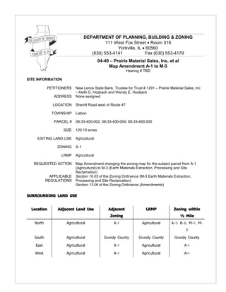
  • 1. DEPARTMENT OF PLANNING, BUILDING & ZONING 111 West Fox Street • Room 316 Yorkville, IL • 60560 (630) 553-4141 Fax (630) 553-4179 04-40 – Prairie Material Sales, Inc. et al Map Amendment A-1 to M-3 Hearing # TBD SITE INFORMATION PETITIONERS New Lenox State Bank, Trustee for Trust # 1291 – Prairie Material Sales, Inc – Keith C. Hosbach and Wendy E. Hosbach ADDRESS None assigned LOCATION Sherrill Road west of Route 47 TOWNSHIP Lisbon PARCEL # 08-33-400-002; 08-33-400-004; 08-33-400-005 SIZE 120.10 acres EXITING LAND USE Agricultural ZONING A-1 LRMP Agricultural REQUESTED ACTION Map Amendment changing the zoning map for the subject parcel from A-1 (Agricultural) to M-3 (Earth Materials Extraction, Processing and Site Reclamation) APPLICABLE Section 10.03 of the Zoning Ordinance (M-3 Earth Materials Extraction, REGULATIONS Processing and Site Reclamation) Section 13.06 of the Zoning Ordinance (Amendments) SURROUNDING LAND USE Location Adjacent Land Use Adjacent LRMP Zoning within Zoning ½ Mile North Agricultural A-1 Agricultural A-1; B-3; M-1; M- 2 South Agricultural Grundy County Grundy County Grundy County East Agricultural A-1 Agricultural A-1 West Agricultural A-1 Agricultural A-1
  • 2. Petition # 04-40 Sherrill Road west of Route 47(Prairie et al) Page 2 of 19 REQUESTED ACTION GENERAL The petitioner, Prairie Material Sales, Inc., is requesting a Map Amendment changing the zoning designation of approximately 120 acres in Lisbon Township from A-1 (Agricultural) to M-3 (Earth Materials Extraction, Processing and Site Reclamation). The purpose of this request is to construct and operate a limestone quarry on the site. The M-3 designation was specifically written for this kind of use, as there are no other zoning designations available for the proposed use. The M-3 is written as a specific, rather than a general, zoning designation in that subsumed in the ordinance language is a set of mandatory conditions that all applicants must follow. A copy of the M-3 language is included in the agenda packet. One of those conditions addresses the issuance of a mine operations permit. See the staff analysis for the request for further details. NRI Review of the NRI report, dated April 23, 2004, reveals the following: • 100% of the soils on the subject parcel are prime soils and the most agronomically productive. • 100% of the soils on the subject parcel are rated “severe” and have limitations for shallow excavations and local roads/streets. • A wetland does exist on the subject parcel. LESA Land Evaluation: 93 Site Assessment: 147 TOTAL: 240 LEVEL OF PROTECTION: High FACTORS The following factors are to be used by the Zoning Board of Appeals when analyzing a map amendment request per Section 13.06.F of the Zoning Ordinance: EXISTING USES OF PROPERTY WITHIN THE GENERAL AREA Existing land uses within 1 ½ miles of the subject parcel are depicted in Volume 1, Exhibit 1 – Land Use Aerial. The subject parcel is currently being used for agricultural purposes and all of the immediately abutting properties are in agricultural use. Overall, 92.5% of the general area is presently in agricultural use. The second most predominant land use in the general area is mineral extraction. This includes the Valley Run Stone and Central Limestone quarries located within a half mile and a mile northwest of the subject parcel. Commercial land use in the general area is limited to the Hogan-Walker/John Deere farm implement dealer located approximately ¼ mile southeast of the subject parcel. Residential land use accounts for less than ½ of 1 % (0.5%) of the land usage in the general area. ZONING CLASSIFICATION OF PROPERTY WITHIN THE GENERAL AREA Existing zoning classifications within 1 ½ miles of the subject parcel are depicted in Volume 1, Exhibit 2 – Zoning Aerial. The subject parcel is currently zoned A-1 Agricultural and is used for agricultural purposes. All of the immediately adjacent
  • 3. properties in Kendall County are zoned A-1 Agricultural and the adjacent properties to the south are zoned A Agricultural by Grundy County. Within the general area there is a variety of existing non-agricultural zoning districts that incorporate mineral extraction either as a legal nonconforming use or as a result of a court order. The Central Limestone quarry property is zoned M-2 Heavy Industrial. Mineral extraction is no longer permitted in the M-2 zoning district, so the Central Limestone quarry is operating as a legal nonconforming use. The Valley Run quarry is operational due to issuance of a Kendall County Circuit Court order. Overall, these existing operations account for 310 contiguous acres of land devoted to mineral extraction in the general area. The only other zoning classification in the general area is a small B-3 designation at the northeast corner of Route 47 and White Willow Road. SUITABILITY OF PROPERTY FOR USES PERMITTED UNDER THE EXISTING ZONING The subject parcel is zoned A-1 Agricultural, and is presently in row crop production. The property is currently used for crop farming, a permitted A-1 use. The suitability of the property for agricultural purposes is evidenced by the high LESA score of 240. The subject parcel is not in the path of advancing nonagricultural development and is surrounded by existing agricultural operations. Suitability for Proposed Use: Certainly a major aspect of suitability is the capacity and physical condition of the local road network to service the proposed use. The applicant has provided a road improvement plan [Volume 1, Tab 11] to the County. This report does not purport to say that this plan is adequate – only that the applicant is aware that it will be an issue. The technical aspect of that plan will be addressed at the mining operations permit stage. Another aspect of suitability is the presence of wetlands on the parcel. Appropriate steps need to be taken in order to protect the wetland. The applicant has provided a plan to address wetland protection. This report does not purport to say that this plan is adequate – only that the applicant is aware that will be an issue. The technical aspect of that plan will be addressed at the mining operations permit stage. Certainly, there needs to be evidence that there is aggregate to be extracted under the subject property. The petitioner has performed borings that indicate the existence of subsurface dolomite limestone. TREND OF DEVELOPMENT IN THE AREA The most prominent use changes that have occurred in the general area since the subject parcel was zoned A-1 has been the readaptation of over 310 acres of land for mineral extraction purposes. Otherwise, the trend of development has been generally stable with agricultural uses dating back to the 19th Century. CONSISTENCY WITH THE SPIRIT OF THE LAND RESOURCE MANAGEMENT PLAN It can be argued that the proposed use of the subject parcel is consistent with the LRMP. The County’s objectives in the area of mineral extraction activities are as follows: G: /REPORTS/2004/04-40/PBZ 04-40 (04.28.05) Prepared by Dale R. Powers, AICP, Senior Planner Page 3 of 19
  • 4. “Identify and conserve areas of mineral resources to assure continued availability of building and engineering materials.” • “Require the development of plans for the implementation of mine[s]...” • “Protect prime mineral extraction areas from encroachment by incompatible uses.” • “Protect other land uses from negative impacts of mineral extraction… through appropriate siting and adequate screening and buffering.” These objectives anticipate the establishment of additional quarries in the County to address the aggregate needs of the County. Location of these quarries, out of necessity, is driven by the location of the deposits to be mined. According to the submittal documents, an estimated 60,000,000 tons of dolomite limestone are present under the subject parcel. It can also be argued that the proposed use of the subject parcel is inconsistent with the LRMP. Section 3.A.1 of the LRMP [p. 3-1] states the following planning goals and objectives in the area of water: • “Maintain and enhance the chemical, physical and biological integrity of the county’s surface and ground waters.” • “Protect natural drainage areas, floodplains and wetlands to avoid costly man-made storm water projects and to protect associated habitats for both flora and fauna. Regulate development to insure that the quantity or rate of runoff does not increase from what currently occurs under natural conditions.” Section 3.A.2 describes the County’s objectives under land use: • “Prevent the disruption of the natural environment by allowing only those land developments and other human activities that exhibit sensitivity to the character and limitations of the natural environment.” Evidence in the record at this time indicates that an aquifer servicing the surrounding agricultural and residential uses will be invaded. The petitioner has submitted a plan to divert this water off the site via Valley Run Creek. However, the record does not indicate what the petitioner plans to do to mitigate the following environmental challenges: • Dewatering: To the extent that this aquifer will be invaded, will this cause all of the water wells in the area to become dry? What is the geographical area of the impact? • Exposing surface waters to evaporation. • Potential of infiltration of pollutants into the water to be discharged. Section 4.B describes the County’s objectives under regulatory techniques: • “Evaluate the need and effectiveness of regulations based on the potential for improving Kendall County’s living, working and natural environments, not simply the protection of property value.” As well, the Lisbon Township LRMP Summary states that mining activity “may be permissible depending on the need for the product in the area and the G: /REPORTS/2004/04-40/PBZ 04-40 (04.28.05) Prepared by Dale R. Powers, AICP, Senior Planner Page 4 of 19
  • 5. impact on the environment.” TOWNSHIP: At its September 14, 2004 regular meeting, the Lisbon Township Board unanimously ratified the recommendation of the Lisbon Township Plan Commission to deny (Lisbon) approval of the map amendment request. Copies of the Minutes from that meeting are included as an attachment to this report. (09.14.04) ZPAC (07.06.04) Highlights from the July 6, 2004 ZPAC meeting on this petition: • Fran Klaas stated that Sherrill Road would need perpetual care with traffic coming in and out of the quarry. • Mike Waldron stated a concern about the potential impacts on Valley Run Creek, specifically where detained water would enter the creek and the rate of release. • Jason Pettit reiterated Waldron’s concerns and also included potential impacts to the neighboring Aux Sable Creek on water quality and impacting on fish in the creek. • Sheriff Richard Randall raised safety concerns for the 47-Sherrill Road intersection, suggesting the installation of turn lanes and traffic lights there. Attorney Robert Britz introduced his team of experts present at this meeting, ready to answer questions if needed. He explained the operations of this proposed quarry stating this was an ideal site for this type of operation. He spoke of the impact on the neighboring area and addressed the issues of blasting, roadways, water, dust and drainage. He spoke of property values and the effect of the economy this site would promote. He feels they can put together a project that would be good for Kendall County that would not be harmful to the neighboring properties. Believing the quarry would affect this area, neighbor Arline Brue asked the board to think about the future potential growth that would be impacted. She also spoke of the traffic and safety concerns from Sherrill Road onto Route 47. Neighbor Gary Anderson spoke of water concerns and the impact on the surrounding wells. Neighbor Henry Babson spoke of water concerns and with his involvement in Real Estate, the negative impact on their property values. In addition to the traffic, noise and dust, neighbor Robert Friestad spoke of his concerns of water, flooding, high PH in the soil, and damage to the crops. Neighbor Milford Bjelland spoke of his concerns of the dangerous truck traffic on Route 47. KCRPC Attorney Bob Britz, representing the petitioner, stated reasons that support the map amendment request: rich mineral reserves, flat topography, distance from urban (09.29.04) areas, lack of centralized water and sewer in the subject area, and accessibility to main arterial roads and railroads. Britz further stated that with the development pressures in the area that the need for aggregate will only increase. Petitioner’s land planner and zoning consultant, Mike Donahue, stated an argument for the “highest and best use” of the parcel as a mining operation and tied his G: /REPORTS/2004/04-40/PBZ 04-40 (04.28.05) Prepared by Dale R. Powers, AICP, Senior Planner Page 5 of 19
  • 6. rationale to the LRMP language of “identifying, conserving and protecting” mineral extraction areas. Petitioner’s Geologic Site Appraiser, Arthur Pincomb, estimated that the estimated reserves on the subject parcel are 40,000,000 tons of “high quality” aggregate material with 15 feet of overburden [the amount of topsoil over the source], and claims that there are no other deposits that meet “these” characteristics in the Chicago area. Pincomb also expanded on Donahue’s “highest and best use” theory by stating that, using the U. S. Department of Justice “Royalty Income Method” of highest and best use, the land is worth $6,000 - $9,000 per acre as agricultural land and $26,000 per acre if mining were authorized for the site. Senior Planner Dale Powers emphasized to the group that it was the role of staff to present both sides to the request and, since the petitioner stated the reasons for granting the map amendment, he spoke of the rationale behind denying the map amendment request. Powers stated that traffic and stormwater issues were two important reasons to consider, and shared with the attendees that stormwater issues had yet to be addressed by Strand Associates, the County’s consulting civil engineer. RPC Secretary Larry Nelson reminded the assemblage of the care and extent in which the County has addressed the Land Resource Management Plan, and stated that the RPC has an important job in protecting the land uses in the County and to consider the impact any one proposed use would have on surrounding areas. Petitioner’s Traffic Engineer, Mike Werthmann, reported that Route 47 has the capacity to accept the additional number of daily trips [120], and indicated that the petitioner intends to improve Sherrill Road to a 40-ton standard from the mine entrance east to Route 47 and to install acceleration/deceleration lanes on Route 47 in the vicinity of the proposed quarry. PUBLIC COMMENTS: Ruth Bell (via letter) – traffic, water and berming issues. The petitioner was forwarded a copy of the letter. Karen Kyrouac – concerns about the impact of surrounding land values, and stated that agricultural property is worth $30,000 per acre and half that if the quarry was allowed. Art Prochaska (Yorkville Mayor) – submitted correspondence from City Attorney Roy Harsch asking for a response to the City’s concerns over ground and surface water, underground fractures, impact on adjacent water wells, impacts of the Aux Sable Creek, traffic, and a comparison between IDOT’s traffic numbers and the petitioner’s traffic numbers. Melissa Barnhart (attorney representing some adjacent property owners) – wanted to clarify the zoning status of the other quarry operations, and reminded the group that the two existing quarry operations never received County approval. The “Shaw” quarry – Central Limestone – was in existence since before the County had zoning regulations, and the “Avery” quarry – Valley Run – is operating under a court order. Barnhart also questioned Pincomb’s statements as running contrary to testimony from him 10 years ago in regards to the Piert farm. Rose Spears (Yorkville Alderwoman) – traffic and public safety concerns. Scott Hoelscher (Northern Pipeline) – impact of blasting on an existing 36-inch, 1000 pound natural gas line that runs along the north edge of the subject property. Chairman Mohr asked that the petitioner and Hoelscher meet to get this issue resolved. Bob Friestad – water and traffic concerns. He shared a photo from a June 10 storm that created ponding, and felt that the proposed berming would create “even more” of a water problem. Joe Slivka (Lisbon Village Trustee) stated that negotiations are ongoing with Valley Run to add 120 acres of quarry area, which will add to the water problem with Valley Run G: /REPORTS/2004/04-40/PBZ 04-40 (04.28.05) Prepared by Dale R. Powers, AICP, Senior Planner Page 6 of 19
  • 7. Creek. Keith Coppelman – inquired into Sunday operations (opposed). Summarizing the public comments, questions posed by RPC members to the petitioner’s centered around impact of land values, impact on the watershed in general, dolomite market value analysis, the Northern Pipeline issue, impacts on ground and surface water, location of the underground fractures, impact on adjacent water wells, and reclamation issues. The public meeting was recessed until 6:30 pm October 19, 2004. KCRPC This is the continuation of the recessed public meeting from September 29, 2004. (10.19.04) In response to issues raised at the 09.29.04 public meeting, the RPC received information from the petitioner on the following issues: Fracture and Groundwater Study: At the 09.29.04 meeting, testimony revealed the potential of a major underground fracture on the site. The Petitioner stated that if the operation of the quarry would cause nearby water wells to dry up, the Petitioner will repair the problem by lowering the pump, deepening the well, or drilling a replacement well at no cost to the impacted well owner. Watershed Impact Study: At the 09.20.04 meeting, a concern was raised that surface water flows would be redistributed from one watershed to another, causing flooding problems to the nearby landowners. The petitioner stated that, in a meeting with Strand Associates, the proposed stormwater discharge plan was reviewed and that said plan met with the preliminary approval of Strand. Landscape Plan: At the 09.29.04 meeting, no detailed landscape plan was forwarded for review and comment. The petitioner acknowledges that the submitted landscape plan will need to be modified and the plan will be resubmitted upon application for a Mine Operations Permit. Pipeline: An engineer with Northern Pipeline will be in contact with the petitioner in order to coordinate this issue. Traffic Impact: The petitioner presented an analysis of this issue from Konig, Lindgren, et al. dated 10.13.04. Geographic Distribution of Dolomite Limestone: The petitioner presented an analysis of this issue from Associated Geologists, Inc. dated 10.14.04. Quarry Operations Impact on Subsequent Commercial Development: The petitioner presented aerial photography of the Vulcan McCool quarry that existed at the time of development of an adjacent shopping center, and stated that the shopping center currently has 100% occupancy. Hours of Operation: The petitioner stated that it would abide by the County’s ordinance that sets the hours of operation at 0600-1900 from 04.01 to 11.01 and 0600-1800 from 11.02 to 03.31. Hours may be extended during a “public emergency” upon issuance of same by the County Highway Engineer. Staff presented correspondence from IDOT dated 03.16.04 that notified Aux Sable G: /REPORTS/2004/04-40/PBZ 04-40 (04.28.05) Prepared by Dale R. Powers, AICP, Senior Planner Page 7 of 19
  • 8. Stone Co. that its 2004 inspection passed, indicating their aggregate gradation limits are acceptable and is classified as a “certified aggregate source” under IDOT’s Aggregate Gradation Control System. This may refute the petitioner’s 09.29.04 claim that the Aux Sable quarry was not “IDOT quality” as required by IDOT for being able to provide road making materials. RPC Questions to the Petitioner: Larry Nelson asked how the proposed quarry location received the quality and amount of limestone indicated in the Petitioner’s study. Art Pincomb noted that this parcel has “Class A” material. Nelson responded that the submitted maps may address the general location of dolomite limestone in the Chicago area but they do not address the thickness of the high-quality dolomite vs. the amount of “chert” [non-aggregate] or amount of [lower grade] “limestone”. A discussion ensued between PBZ staff and the petitioner on the interpretation of “highest and best use”. Petitioner’s Real Estate Appraiser Mike McCann presented a land sales study for agricultural property alone Route 37 from I-80 in Morris, IL to the Wisconsin border. RPC Chair Randy Mohr stated that the “highest and best use’ is not always financially driven. Annette Hattner questioned the direct economic impact of the quarry on tax receipts such as property and sales tax. The petitioner responded that “99%” of the sales would be to contractors and thus exempt from sales tax. [There was nothing in the record as to the property tax question.] PBZ Staff continues to have a concern about the proposed location atop a watershed divide. Illinois drainage law prohibits cross-watershed water transfers. Public Comments: Ralph LeGrand – traffic flow issues and stated that Historic Route 66 near the McCook quarry was closed due to the damage caused by heavy truck traffic. Petitioners Attorney Bob Britz responded that the laws have changed and that the petitioner has an obligation to see that the roads are maintained. Karen Kyrouac – restated her property value concerns. Henry Babson – quarry life cycle issues. Melissa Barnhart – attorney representing several adjacent property owners – pipeline safety issues. RPC Chair Randy Mohr asked the petitioner to get this issue settled in writing prior to the 12.08.04 RPC meeting. Barnhart also asked if there are any IDNR issues regarding the Boughton quarry. The petitioner responded that there is a pending case but does not know the status of it. Bob Friestad – traffic study of Joliet Road. Karla Stacy – traffic safety. Kris Swenson - farmland preservation. Dick Wagner – “strategic planning specialist” – supported Ms. Swenson’s comments and stated that the rich productive soils of this region need to be kept in production. Larry Nelson asked whether the site could be returned to productive farmland when the soil has been stripped and the reserves depleted. Petitioner Robert Furlong responded that this can be done and is being done in two other locations. Annette Hattner asked whether the petitioner is making a financial commitment to the road improvement to Sherrill Road and Route 47. The petitioner stated it is and the estimated cost of the improvement is in the $250,000 - $500,000 range. The public meeting was recessed until 6:30 pm December 8, 2004. G: /REPORTS/2004/04-40/PBZ 04-40 (04.28.05) Prepared by Dale R. Powers, AICP, Senior Planner Page 8 of 19
  • 9. This is the continuation of the recessed public meeting from October 19, 2004. KCRPC RPC Chairman Randy Mohr received correspondence dated 11.01.045 from Mike Sitterly, president of The Western Sand and Gravel Company of Spring Valley, IL – (12.08.04) the company which operates the Aux Sable Stone Quarry. The letter disputes the testimony of Petitioner’s Geologic Site Appraiser Art Pincomb on the submitted market study and analysis of the quality of material produced at the Aux Sable quarry. This letter was entered into the record. In response, Pincomb stated that the Aux Sable quarry was included in the report as part of the market study that produced “a good quality of stone”. In response to Larry Nelson’s question about market competition, Pincomb stated that “with competition, costs could be controlled.” Claire Wilson asked the petitioner if they had reviewed the report from the County’s consulting geologic expert, Dr. William Lang, which raised questions regarding the geology of the area. Petitioner’s Civil Engineer, Gordon Stephens of Patrick Engineering, stated that he had read Dr. Lang’s report and that an “extensive” hydrogeologic study was performed and the study confirmed that the permeability of the site was consistent. Stephens also indicated that potential fracture areas were identified. The petitioner does not anticipate any impact to surrounding water wells but, if such an impact were to arise that the petitioner would cover the costs of restoring the water to the impacted wells. Correspondence was received from the City of Morris. The City states that commercial developers are attracted to the City by its centralized location 20 miles north of Dwight – 20 miles west of Joliet – 20 miles south of Yorkville – and 20 miles east of Ottawa. The City’s comprehensive land use plan called for Route 47 to be developed as a commercial corridor. The City’s planning area extends north to Minooka Road, 1 mile south of the subject site. Strand Associates outlined its engineering concerns and listed 14 items that are still outstanding as of this time. Strand’s primary concern is the proposed diversion of stormwater runoff across watershed divides. Jim Pore of Prairie Materials met with the adjoining neighbors and stated that the drainage design – which Pore said was similar to the drainage design at its Pontiac, IL facility – met with the approval of the neighbors. There being no further comments, Nelson/Ashton moved to approve Petition 04- 40. The motion failed by a 1-9 vote, with all RPC members voted in the negative except for member Wilson. [NOTE: A copy of the minutes of the three RPC meetings is attached to this report.) The main reasons for the failure of the motion are as follows: • The petitioner did not establish the needs for the product as required in the Land Resource Management Plan. • Faulting on the site presents a risk to groundwater supply. • The watershed issue is not being fully addressed. • Prime farmland should be protected. • The highest and best use of the land is agriculture. G: /REPORTS/2004/04-40/PBZ 04-40 (04.28.05) Prepared by Dale R. Powers, AICP, Senior Planner Page 9 of 19
  • 10. ZBA After entering into the record Volumes 1-3 of the Application Submittals, the Addendum to the Submittals, the Preliminary Review of the Submittal documents by (02.15.05) Dr. William Lang, Ph. D., the County’s consulting geologic engineer, the decision in Peart et. al v. County of Kendall (93-MR-23, a/k/a the “Feltes” decision), the staff report prepared by PBZ staff, all minutes of the proceedings of the Lisbon Township Plan Commission and Lisbon Township Board, Kendall County Regional Planning Commission, and a publication called “Illinois Drainage Law” from the University of Illinois, State’s Attorney Tim McCann swore in all those who wished to testify at this public hearing. Refer to the unapproved minutes of this meeting, which are included as an attachment to this report. This portion of the public hearing consisted of the following: 1. The petitioners presented their case. 2. The petitioners responded to questions from ZBA members. Martin/McKay unanimous to recess the public hearing until March 1, 2005 at 6:30 pm in the County Board Room. ZBA Refer to the unapproved minutes of this meeting, which are included as an attachment to this report. This portion of the public hearing consisted of the following: (03.01.05) 1. The petitioners responded to questions from ZBA members. 2. Cross-examination of the petitioners by attorney’s representing legal objectors to the map amendment. Martin/Cryder unanimous to recess the public hearing until March 21, 2005 at 6:30 pm in the County Board Room. ZBA Refer to the unapproved minutes of this meeting, which are included as an attachment to this report. This portion of the public hearing consisted of the following: (03.21.05) 1. Testimony from the public. 2. Testimony from Mike Waldron, P. E. of Strand Associates, the County’s consulting civil engineer. 3. Testimony from William Lang, Ph. D., P. G., the County’s consulting geologic engineer. 4. Cross-examination of Lang by the Petitioners’ Attorney. 5. Rebuttal witnesses called by the Petitioners’ Attorney. 6. Closing arguments by the Petitioner. 7. Closing arguments by the Legal Objectors. McKay/Friedrich unanimous to recess the public hearing until April 4, 2005 at 7:00 pm for a final recommendatory vote by the ZBA. Due to a conflict of interest, Chairman Bill Ford stated he would abstain from ZBA voting. (04.04.05) The following FINDINGS OF FACT questions for MAP AMENDMENTS were asked and voted upon by the ZBA: 1. Are the proposed uses compatible with existing uses nearby? NO 4-2 (Reinert, Martin) G: /REPORTS/2004/04-40/PBZ 04-40 (04.28.05) Prepared by Dale R. Powers, AICP, Senior Planner Page 10 of 19
  • 11. 2. Is the proposed district compatible with existing districts nearby? TIE 3-3 (Reinert, Martin, Cryder YES; Friedrich, Stees, McKay NO) 3. Is the site physically suited for the proposed uses? NO 5-1 (Martin) 4. Is the proposed district compatible with the trend of development nearby? NO 4-2 (Reinert, Martin) 5. Is the proposed amendment in the public interest? NO 4-2 (Reinert, Martin) After the FINDINGS OF FACT were determined, Martin/Stees 2-4 (Friedrich, Cryder, McKay, Stees) to recommend approval of the petitioners’ request for map amendment. The motion failed. Refer to the unapproved minutes of this meeting, which are included in this report as an attachment, for the reasons cited by each member for their vote. CONCLUSION A map amendment is a legislative act of the County Board. As such, the Board can weigh in on public opinion in the decision and is not 100% bound by a quasi- judicial findings process. This is especially important when the amendment changes the zoning designation to an industry-specific “M-3”, since by granting the map amendment the Board is signaling its willingness to consider issuing the mine operations permit. RECOMMENDATION As outlined in the minutes and summarized within the staff report, both the Regional Plan Commission and Zoning Board of Appeals found that they could not support the requested rezoning to M-3 for the reasons indicated in their analysis of the request and the motions which are part of the case record. At this point in the process, staff is not making a recommendation on the map amendment. The reason for the unusual level of staff ambivalence on this issue is that, based on the record to date, arguments can be made both to support and to deny the zoning map amendment. Given that Kendall County is the 2nd-fastest growing county [in rate of growth] in the United States, and that the “collar counties” around Chicago are also experiencing a level of growth, the need for aggregate to service this growth can not be denied. Quarries tend to congregate in a particular location not due to economies of scale, but due to the location of the underground material to be extracted. As well, the petitioner operate several quarries in the region and has the financial wherewithal to operate the proposed quarry in a quality manner consistent with the expectations of the community. Finally, the petitioner has demonstrated a sensitivity to the issues surrounding the negative externalities common with quarry operations and has indicated a willingness to utilize its operations experience to mitigate – if not obviate – these externalities. On the other hand, It is clear from the evidence and testimony presented to date that the solutions to these negative externalities will only be revealed after the granting of a zoning map amendment. Of concern to the PBZ staff is the question of whether the underlying strata and deposits contain factures that could potentially have a significant impact of the groundwater resources in this area. In addition, while the County’s engineering consultants agree that the initial plan for discharging run-off and ground water from this site is the most practical, it would appear to be in conflict with a strict interpretation of Illinois Drainage Law. G: /REPORTS/2004/04-40/PBZ 04-40 (04.28.05) Prepared by Dale R. Powers, AICP, Senior Planner Page 11 of 19
  • 12. The County mining ordinance and the State of Illinois and Kendall County permitting process require mechanisms to be in place to offset the impacts of traffic, dust, noise, vibration and to insure appropriate reclamation of the site. However, as previously indicated, the specifics on how those impacts will be offset are not known at this time. If a major issue comes up afterward that can not be overcome that prevents the petitioner from obtaining the necessary mining operations permit, the county and the petitioner would be left with 120 acres of M-3 zoning that is un-useable. At this time it is unclear whether a county, in the exercise of its zoning authority, can put an effective date on a zoning map amendment. The answer to that question may cause the level of staff ambivalence on this issue to dissipate. Given that the issues associated with potential fractures, groundwater and surface water run-off will likely not be able to be addressed until the permit stage, staff is providing the Board with an analysis of the factors listed in the Section 13.06.F of the zoning ordinance which are based on the LaSalle/Sinclair factors that are traditionally used in developing a finding of fact in making recommendations on zoning requests. The actual factors contained in our ordinance for making a finding of fact on a zoning map amendment are listed below and are cross-referenced with the corresponding LaSalle/Sinclair factors. For the record it should be noted that LaSalle/Sinclair includes two additional factors not directly addressed in the County’s finding of fact. The analysis is being offered provides both an argument for granting the amendment as well as one for denial. If the County Board, after reviewing the record at the time of the decision, finds that the petitioner has adequately demonstrated that there is a clear need for the use and that the related environmental and health, safety and welfare issues have been adequately addressed, it should vote to approve the request for map amendment from A-1 to M-3. Factors that can be used by the County Board in support of the map amendment: SEC 13.06.F.1: Existing uses of property within the general area of the property in question. LA SALLE/SINCLAIR: Existing uses and zoning of the property. An examination of the Kendall County Zoning Map will show that the existing uses and the zoning of nearby property is predominantly agricultural with the exception of the two existing mining operations northwest of the proposed site and a small B-3 parcel at the northeast corner of Illinois Route 47 and Whitewillow Road. Of the two existing mines, one was granted by Court order while the other property is zoned M- 2. The presence of the two existing mining operations and an M-2 district in close proximity to the proposed site establishes this area as a suitable location for the extraction of limestone and similar minerals and an M-3 designation. SEC 13.06.F.2: The zoning classification of property within the general area of the property in question. While it is true that over 90% of the property within 1.5 miles of the outer perimeter of the subject parcel is zoned A-1 Agricultural, rarely are quarries sited on land already zoned for quarries as an allowed or permitted use. In virtually each instance, acreage G: /REPORTS/2004/04-40/PBZ 04-40 (04.28.05) Prepared by Dale R. Powers, AICP, Senior Planner Page 12 of 19
  • 13. proposed for a quarry has a pre-existing zoning classification that needs amending to allow for the quarry usage. Testimony in the record indicates that there is a higher compatibility of quarry operations with agricultural operations that with residential and/ or commercial uses. In most situations, the existing zoning classification for the land proposed for a quarry is agricultural. LA SALLE/SINCLAIR: Extent to which property values are diminished by particular zoning restrictions. In general, agriculturally zoned properties rank relatively low on the continuum of land uses. In contrast, commercially zoned properties rank toward the top end of the scale and are certainly considered to have a higher value. Properties in close proximity to commercial uses or nearby areas in which the trend of development is more commercial in nature often have higher values than properties far removed from the influence of commercial or non-residential development. While the county’s M-3 district is very specific and contains a very limited range of uses, it can not be denied that an industrial zoning designation would typically rank higher in terms of value when compared against an agriculturally zoned property. Therefore it could be argued that the proposed use could have a positive impact on land values in the immediate area. LA SALLE/SINCLAIR: Relative gain to the public as compared to the hardship of the individual property owner. There can be no question that Kendall County is experiencing an increasing rate of development. As can be evidenced and documented with the growth of such counties as DuPage, Will, Kane and the other collar counties within the Chicagoland area, growth and development brings with it an increase in demand for natural resources to fulfill the needs of a wide variety of construction projects. Foundations for buildings and the need to upgrade, widen and construct new roadways to serve the increasing population and employment base will definitely create a demand for aggregate as noted in the studies supplied by the applicant in support of their petition. Having an adequate supply of aggregate within reasonable proximity of the area generating the demand could be viewed as being in the public’s interest by minimizing the distance the material has to be transported which does have an impact on cost. SEC 13.06.F.3: The suitability of the property in question for the uses permitted under the existing zoning classification. LA SALLE/SINCLAIR: Suitability of the property for the zoned purposes. While it is true that the LE score and existing use of the property (row crop production) demonstrates that the property is certainly suitable for agricultural uses under its existing A-1 (Agricultural) zoning classification, it could also be argued that the proposed zoning is equally suitable. As demonstrated in the geologic reports submitted as part of the supporting documentation as part of the rezoning request, a significant deposit of dolomitic limestone is present in the subsurface strata at a depth of anywhere from eight to thirty-seven feet of the surface. On average 15 feet was the depth most commonly encountered based on the nine brings reported in the appraisal report (Tab 7 Volume I). The presence of this resource within the immediate area is also evidenced by the presence of the two existing mining operations within a mile of the project location. That fact coupled with the limited population density found in the surrounding area and relatively close proximity to Route 47 seem to favor the placement of this type of use at this location. Given that blasting operations will be associated with this use, having the site located away from G: /REPORTS/2004/04-40/PBZ 04-40 (04.28.05) Prepared by Dale R. Powers, AICP, Senior Planner Page 13 of 19
  • 14. more densely populated areas could be seen as beneficial and would likely have less impact on the public. In addition the vehicles transporting the materials will need to be in close proximity to transportation facilities that can support not only the volume of truck traffic anticipated but also the weight of the vehicles involved in transporting the aggregate. Given that Route 47 is located within a half mile of the proposed project, is an existing state highway, and is identified on the County’s Transportation component of the LRMP as an arterial roadway designed to handle this type of traffic, it would appear that the proposed site could be argued to be suitable for the zoning that is proposed. SEC 13.06.F.4: The trend of development, if any, in the general area of the property in question, including changes, if any, which may have taken place since the day the property in question was in its present zoning classification. The Zoning Board of Appeals shall not recommend the adoption of a proposed amendment unless it finds that the adoption of such an amendment is in the public interest and is not solely for the interest of the applicant. LA SALLE/SINCLAIR: The evidence or lack of evidence of community need for the use proposed. LA SALLE/SINCLAIR: Does the restriction have a basis in public health, safety, and welfare? An argument could be made that locating the use in this particular location within close proximity to two existing mining operations is placing the use in an area already exposed to the impacts of noise, vibration dust and wastewater being generated within a more compact and centralized zone as opposed to disbursing them throughout the County where those impacts could potential be spread over a broader area. In addition, locating the mine in close proximity to the two existing operations where the population is less dense and is planned for retention of low density agricultural uses could be seen as plus again by confining the impacts from blasting to areas and uses that contain less population and fewer structures. The argument could also be made that increasing the availability of aggregate would be a convenience to residents. The petitioner has supplied information concerning the growth projections for the County and has cited this as evidence that there is a demand for this particular use and product As indicated in the preceding discussion, there is no question given the level of current and projected level of growth and construction activity that there is a need for building and engineering materials such as limestone and limestone related products. It should be noted that the issue of whether or not the creation or establishment of this use will impact the economic success of this or any other similar use or operation should not be taken into consideration in reaching this decision. The basis should be clearly restricted to the issue of need within the community. While it is true that the vast majority of the area within 1.5 miles of the subject parcel is zoned A-1, and it is true that the major non-agricultural activities – commercial quarries – were in one case in operation prior to the adoption of the zoning ordinance and in the other case imposed via court order, the trend of development still favors the request for map amendment. Quarries prefer to be sited as far away from the potential for non-agricultural development as practicable. This is due to the fact that the negative externalities associated with the daily operations of a quarry would be experienced by fewer adjacent property owners, as well as potential future non- agricultural uses being less likely to conflict with the mining operation. The subject site is 6 miles north of Morris, 10 miles south of Yorkville, and 10 miles west of G: /REPORTS/2004/04-40/PBZ 04-40 (04.28.05) Prepared by Dale R. Powers, AICP, Senior Planner Page 14 of 19
  • 15. Minooka. To the west, while Lisbon is less than 3 miles away, the Village is actively pursuing annexation of commercial quarries in order to earn a “tipping fee” for much- needed infrastructure improvements. In other words, residential development of the kind and scale presently experienced in the aforementioned municipalities, as well as the northern ½ of unincorporated Kendall County, are years – if not decades – away. SEC 13.06.F.5: Consistency with the spirit of the Land Resource Management Plan and other adopted County or municipal plans and policies. LA SALLE/SINCLAIR: The care in which the community has undertaken to plan its land use development. The County has stressed the importance through out its LRMP of managing its natural resources and minimizing conflicts between non-compatible land uses. Compact development is encouraged that encourages higher density residential and larger more intensive commercial and industrial development to take place within or adjacent to existing municipal areas Within Section Three “Planning Goals and Objectives”, under the heading “Natural Resources – Land” the LRMP indicates the County should “identify and conserve areas of mineral resources to assure continued availability of building and engineering materials.” Later on in this same section under the Heading “Economy of the Area” it states that the plan should “protect prime mineral extraction areas from encroachment by incompatible uses” and later in this same section “protect other land uses from negative impacts of mineral extraction and heavy industry through appropriate siting and adequate screening and buffering.” While mineral resources are typically considered natural resources, the plan does not specifically include or reference mineral deposits in this overall heading. Flood plain, water recharge areas wetlands, prairies savannahs and significant concentrations of woodlands are however included. In addition, the plan includes summaries regarding each of the nine townships. To date more detailed sub-area plans have been developed for eight of the nine townships. Under the current text of the Lisbon township summary addressing existing land use, it states “Productive farm land constitutes most of the undeveloped area except a sizeable concentration of limestone located in the Township.” Under the “Future Land Use” component of the summary, it states “Limited commercial and light industrial development can be accommodated along the major highways of Route 47 & Route 52. Agricultural related business development is encouraged. Mining activity may be permissible depending upon the need for product in the area and the impact on the environment.” Lisbon is the only Township in which the issue of mining or as a land use is mentioned as a potential use. It could therefore be argued that while the plan does not show a specific location for this type of use, it does recognize that the potential exists to allow for and accommodate mining operations. By identifying it as an agricultural area on the plan but indicating within the text that some mining limited commercial and manufacturing uses may be appropriate in certain areas of the township provided certain safeguards are in place, the County is accomplishing the goal of preserving this resource from the unwanted encroachment of development which might jeopardize the ability to access the resource in the future. In addition showing the area as agricultural places the land in a category that prevents the encroachment of other uses that could create conflicts and which could be considered incompatible with mining (i.e. residential or more heavily concentrated suburban development) Therefore the County has carefully planned for the accommodation of such uses within this area and an argument could be, given the text of the plan, that the request could be supported. ------------------------------------------------------------- - G: /REPORTS/2004/04-40/PBZ 04-40 (04.28.05) Prepared by Dale R. Powers, AICP, Senior Planner Page 15 of 19
  • 16. On the other hand, if the County Board finds that the petitioner has not demonstrated a clear and compelling need for the request and has not adequately addressed the environmental and health, safety and welfare issues, it should vote to deny the request for map amendment from A-1 to M-3. Factors that can be used by the County Board in support of denial of the map amendment: 13.06.F.1: Existing uses of property within the general area of the property in question. LA SALLE/SINCLAIR: Existing uses and zoning of the property. An examination of the Kendall County Zoning Map and the Kendall County Land Resource Management Plan (LRMP) will show that the existing uses and the zoning of nearby property is almost exclusively agricultural. The only exceptions are existing mining operations and a small B-3 parcel at the northeast corner of Illinois Route 47 and Whitewillow Road. The record to date indicates that there is a difference of opinion on the level of compatibility of agricultural and mining activity in close proximity to each other. This, at a minimum, suggests that the potential exists for conflicts between the two uses. SEC 13.06.F.2: The zoning classification of property within the general area of the property in question. Within 1.5 miles of the outer perimeter of the subject parcel, over 90% of the land is zoned A-1 Agricultural. The two existing quarries do not exist due to an affirmative act of the County to grant zoning consistent with a mining operation. Central Limestone existed prior to the initial adoption of a county zoning ordinance, and Valley Run is in operation by benefit of a court order. LA SALLE/SINCLAIR: Extent to which property values are diminished by particular zoning restrictions. Certainly, any land that is zoned for earth extraction will always be more valuable than land zoned for agricultural use. Bear in mind that agricultural use is the lowest rung in the continuum of land uses, with M zoning the highest rung. No matter who the current property owner ultimately sells the property to, they will realize a capital gain. Moreover, the very thing that makes the property valuable is the underlying geology. Certainly the value of the underlying geology is what is driving the purchase price and it can not be disputed that if the seller sold the parcel for agricultural uses the price would diminish. Just because the seller has found a buyer that will pay an inflated price for agricultural land does not mean that the buyer should be permitted to develop the land in a manner that is entirely inconsistent with contiguous land uses, zoning ordinances and local land use plans. LA SALLE/SINCLAIR: Relative gain to the public as compared to the hardship of the individual property owner. With respect to the matter of the hardship imposed on the individual property in relation to the relative gain to the public, this issue is difficult to quantify. While there is no question Weitendorf would likely obtain a greater monetary benefit from the sale of the property if it were rezoned from A-1 to M-3, we fail to see a specific hardship in this case. Furthermore, presumed amount of economic loss or gain to an individual property owner is not a valid basis for considering the merits of a request. As for Prairie Materials, the firm would suffer no hardship whatsoever if the map G: /REPORTS/2004/04-40/PBZ 04-40 (04.28.05) Prepared by Dale R. Powers, AICP, Senior Planner Page 16 of 19
  • 17. amendment is denied. They do not own the property and would not be stuck with the property, unable to develop it as they wish. The seller would simply find another buyer, perhaps at a lower price as outlined above, but would suffer no significant hardship. There would be no relative gain to the public. There is no evidence of need for a limestone quarry of this nature to service the community needs of Kendall County. An existing quarry, operating under a court order, needs to demonstrate a community need – a market – for additional aggregate in order to expand its operations. As of the date of this report, that demonstration has yet to be made in front of the presiding judicial authority. SEC 13.06.F.3: The suitability of the property in question for the uses permitted under the existing zoning classification. LA SALLE/SINCLAIR: Suitability of the property for the zoned purposes. As mentioned earlier in this report, the subject parcel has a LESA score of 240, indicating a high level of protection. The County has a tradition of protecting prime agricultural land from non-agricultural uses. This tradition is even more important to maintain given the high rate of conversion of prime agricultural land to residential uses. Maintaining the existing zoning also maintains the sanctity of the groundwater for human consumption. Finally, agricultural land is a valuable resource in and of itself and is worthy of protection. SEC 13.06.F.4: The trend of development, if any, in the general area of the property in question, including changes, if any, which may have taken place since the day the property in question was in its present zoning classification. The Zoning Board of Appeals shall not recommend the adoption of a proposed amendment unless it finds that the adoption of such an amendment is in the public interest and is not solely for the interest of the applicant. LA SALLE/SINCLAIR: The evidence or lack of evidence of community need for the use proposed. LA SALLE/SINCLAIR: Does the restriction have a basis in public health, safety, and welfare? Absolutely the proposed use can be viewed as potentially having an adverse impact on public health, safety and welfare. The record indicates some controversy over the geologic suitability of the subject parcel for the proposed use. To date, the petitioner has not performed underground fracture studies that would give solace to those who fear the “dewatering” of the underground aquifer by the proposed use, thereby potentially creating the need for an expensive community water service for those property owners relying on the water supplied by the invaded aquifer. As well, the potential for exposure of the aquifer to air will increase evaporation and possible pollution of the natural resource. Finally, while the level of additional vehicular traffic is minimal, the speed differential between large, slow-moving commercial vehicles and normal passenger vehicle traffic can create a safety hazard at Sherrill Road and Route 52. The petitioner states [Tab 8, p. 4] “the population in Kendall, Grundy, LaSalle, Will, DeKalb, and Kane Counties will increase by 1,000,000 by the year 2030…… employment will increase by more than 500,000…traffic will increase 76% by 2030……”. The petitioner states that as a determination of need for the aggregate. However, there is no evidence in the submittal that the needs of the Kendall County community demand additional aggregate; or that the existing use of the property in agricultural production is somehow not needed in Kendall County. The petitioner’s definition of “community” appears somewhat subjective and was defined to place the subject parcel in the center of that area for business reasons and not for the altruistic G: /REPORTS/2004/04-40/PBZ 04-40 (04.28.05) Prepared by Dale R. Powers, AICP, Senior Planner Page 17 of 19
  • 18. motive of supplying Kendall County with an adequate supply of dolomite. If the subject area was defined as Kendall, LaSalle, Grundy, Livingston, and Bureau Counties, it is suspected that the need for aggregate in that “community” would be much less. Simply put, there IS no “trend of development” in this area. Other than the Village of Lisbon – which can’t provide a level of services required for municipal development – there are no municipalities within 6 miles of the subject site in a position to service it with sewer and water service. This is an agricultural area and has been zoned that way – with the occasional commercial zoning – since the advent of zoning. The petitioners’ claim that the existing zoning for Valley Run and Central Limestone establish a precedent that should be honored with their request for map amendment. The fact that Central Limestone was in operation prior to adoption of the first zoning ordinance, and that Valley Run Quarry operates under benefit of a court order, indicates that the County never made an affirmative act of granting zoning for those uses and, in fact, followed the desires of the residents of the affected township in maintaining the zoning as agricultural. SEC 13.06.F.5: Consistency with the spirit of the Land Resource Management Plan and other adopted County or municipal plans and policies. LA SALLE/SINCLAIR: The care in which the community has undertaken to plan its land use development. Kendall County initially adopted a LRMP in 1994. Since that time it has been amended several times to reflect the evolving nature of the growth patterns in the County, and in response to the intensification of land uses within the municipalities in and near the County. In the current LRMP, two of the stated policy goals [p. 2-2] are “While it is physically and economically feasible to farm and live a farm life, most residents prefer to see agricultural lands remain intact and protected from urbanization and penetration by non-agricultural activities” and “Protection of the County’s rural character is critical to maintaining the quality of life within Kendall County.” While it is true that there are other policy goals that would indicate a desire for additional employment opportunities, it can not be inferred that the County has no discretion in determining which employment opportunities are appropriate and in keeping with the image the County wants to project for itself. This is especially true when it relates to land use at entrances to the County, where the initial image of the County is burned into the memory of those entering its jurisdiction. There can be no question that the County has undertaken a thoughtful effort in keeping its LRMP up to date. Not only has the County planned its land use development with great care, it is abundantly evident that the map amendment proposed by Prairie Materials does not fit. There is nothing on the LRMP map that would indicate or allow anyone to predict that the subject parcel was intended to be used in a manner sought by Prairie. While it is true that existing aggregate quarries operate to the northwest of the subject parcel, and that there exists a vein of limestone underneath the subject parcel, it does not follow that the mere presence of aggregate automatically entitles a petitioner a property right to a zoning classification consistent with the extraction of said aggregate. Given the level of thought and foresight the County has given to its planning process, it can be reasonably deduced that a clear demonstration of need by County residents would need to found. In this case, the record does not indicate the need exists in Kendall County for additional aggregate. ATTACHMENTS 1. Volumes I, II, III of the Application Submittals (Previously Supplied to PBZ/COW) 2. Addendum of the Application Submittals (Previously Supplied to PBZ/COW) G: /REPORTS/2004/04-40/PBZ 04-40 (04.28.05) Prepared by Dale R. Powers, AICP, Senior Planner Page 18 of 19
  • 19. 3. Minutes from Lisbon Twp dated 08.10.04 and 09.18.04 4. Minutes from the Regional Planning Commission public meeting of 09.29.04, 10.19.04, and 12.08.04 5. Minutes from the Zoning Board of Appeals public hearing of 02.15.05, 03.01.05, 03.21.05, & 04.04.05 6. Preliminary Review by William J. Lang, Ph. D., P. G., Consulting Geologic Engineer of the County 7. Illinois Drainage Law publication G: /REPORTS/2004/04-40/PBZ 04-40 (04.28.05) Prepared by Dale R. Powers, AICP, Senior Planner Page 19 of 19