WMT Wildfire Management Tool GIS Day Poster 2015
•Télécharger en tant que PPTX, PDF•
1 j'aime•712 vues

Wildfire Management Tool (WMTweb) Poster for GIS Day 2015. World GIS Day at Ventura College A GIS conference for Santa Barbara, Ventura and the surrounding regions. Friday, November 20, 2015.
Recommandé

Recommandé
Contenu connexe
Tendances
Tendances (19)
Similaire à WMT Wildfire Management Tool GIS Day Poster 2015
Similaire à WMT Wildfire Management Tool GIS Day Poster 2015 (20)
Dernier
Dernier (20)
WMT Wildfire Management Tool GIS Day Poster 2015
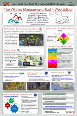
- 1. The Wildfire Management Tool – Web Edition Using NASA Web World Wind to Predict Wildfire Behavior Combining the Art of the Campbell Prediction System (CPS) with the Science of the Rothermel (BEHAVE) algorithms to ensure the safety of wildland firefighters and the effective use of firefighting resources. Fire behavior intensity is depicted for all four quadrants. Arrow depicts direction of head fire. Intensity Flame Description Low 0-1’ Very little resistance to control and direct attack with firefighters is possible. Moderate 1’-3’ Moderate resistance to control but can be countered with direct attack by firefighters. Active 3’-7’ Substantial resistance to control. Direct attack with firefighters must be supplemented with equipment and/or air support. Very Active 7’15’ Extreme resistance to control. Indirect attack may be effective. Safety of firefighters in the area is a concern. Extreme > 15’ Extreme resistance to control. Any form of attack will probably not be effective. Safety of firefighters in the area is of critical concern. New Symbol – The Wildfire Diamond Weather Scouts National Weather Service point weather forecasts are rendered using standard weather station symbols. • Simply drag-n-drop Weather Scouts to where you want to know the wx. • Weather Scouts show: • Sky cover • Wind speed and direction • Air temperature (F) • Relative humidity (%) • Weather Scouts are spatiotemporal markers. Fire Lookouts – Dynamic Spatiotemporal Markers Fire behavior is the manner in which a fire reacts to the influences of: fuel, weather, topography. • Simply drag-n-drop Fire Lookouts where you want to know the potential fire behavior. • Fire Lookouts show fuel model, flame lengths for head, flanks & heal, and direction of max spread. • Fire Lookouts react to changes in weather and temporal solar conditions. Fire Behavior Thresholds of Control Built on NASA’s Web Word Wind SDK http://webworldwind.org/ • JavaScript API • Well crafted; extensible, easy to use • Custom shapes • Analytic surfaces, rigid shapes, terrain conforming surface shapes, volumes, place marks, geographic text, …. • 3D globe and continuous 2D map mode with extensible projections • KML and Collada support • Flexible and extensible viewing and navigation system • Shapefile support • WCS and WMS support 3D Globe Visualization Imagery Terrain LANDFIRE Fuel Models NASA World Wind’s Earth Elevation Model • WMS: http://worldwind26.arc.nasa.gov/elev/ • USGUSGS NED 10m (USGS-NED) • ASTER GDEM Version 2 30m (aster_v2) • General Bathymetric Chart of the Oceans (GEBCO) NWS Point Forecasts National Digital Forecast Database (NDFD) REST Web Service • http://graphical.weather.gov/xml/rest.php • Results in Dynamic Weather Markup Language (DWML), i.e., XML • Website: http://www.landfire.gov/ • Standard 40 Fuel Models • Original 13 Fuel Models • Vegetation Heights • Open Source Software, BSD 3-Clause License Type • wmt.emxsys.com Web App URL • bitbucket.org/emxsys/wildfire-management-tool-web Open Source Project Website • Bruce Schubert • Email: bruce@emxsys.com Project Sponsor GIS Day 11.20.2015 Ventura, CA