Roundup 2010 Poster
•
0 j'aime•162 vues

This is a recent poster describing the distribution and thickness of cover (basalt lavas and glacial drift) in central BC

Recommandé
Contenu connexe
Similaire à Roundup 2010 Poster
Similaire à Roundup 2010 Poster (20)
Dernier
Dernier (20)
Roundup 2010 Poster
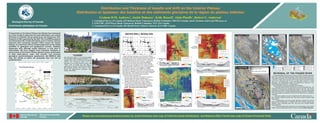
- 1. Distribution and Thickness of basalts and drift on the Interior Plateau Distribution et épaisseur des basaltes et des sédiments glaciaires de la région du plateau intérieur 1 2 2 3 1 Graham D.M. Andrews , Jackie Dohaney , Kelly Russell , Alain Plouffe , Robert G. Anderson Geological Survey of Canada 1. Geological Survey of Canada, 625 Robson Street, Vancouver, British Columbia. V6B 5J3 Canada; email: Graham.Andrews@NRCan.gc.ca 2. EOS-UBC, 6339 Stores Road, Vancouver, British Columbia. V6T 1Z4 Canada Commission géologique du Canada 3. Geological Survey of Canada, 601 Booth Street, Ottawa, Ontario. K1A O8E Canada Prospectivity on the Interior Plateau has hitherto been hampered A B by a lack of data to determine the areal distribution and vertical WATER WELL MODELING 093A/05 093J/03 093J/02 Y 093J/01 A - intraglacial c. 1.06 Ma B - deglaciation post-1.06 Ma C - intraglacial >30 ka RO buried thickness of Chilcotin Group basalt lavas and Quaternary drift. McLeese Lake paleochannel ? CK Water Well Records (n = 10,486) Bedrock Intersection Points (n = 3,189) Y Peace Drainage M TN y S e Vall CA RI Research at UBC supported by the GSC TGI-3 and MPB programs BO O buried (Arctic) ser M 0 km 10 TN S paleochannel Skeena Skeena Fra 093K 093J 093I 093K 093J 093I INTE Fraser-Peace RIOR 1:500,000 and Geoscience BC reveals that basalt cover is thinner and less V V C O A ST PLAT EAU S 093G/15 Ferndale 093G/16 Drainage Drainage Basin Drainage extensive than previously thought (<40%) across the Interior PG PG Miocene M TN S Basin (Arctic) Basin 093F 093H 093F 093H 093B/08 alley 093G 093G ako V Plateau. It is only thick (>20 m) in paleovalleys that can be readily RO CK Y M 093B/01 X’ 093A/04 N ech Prince George Q TN identified in geological and geophysical surveys. Similarly, S Q CA RI BO O 4 - Prince X’ M TN George area Quaternary drift, although areally extensive, is only thick in S 093C 093B 093A 093C 093B 093A INTE RIOR WL WL Williams Lake X paleovalleys. We have mapped cover thickness variations in C O A ST PLAT EAU S Beaverley bedrock intersection point Fraser Valley M TN 093G/14 S ‘C ‘C several areas on the Interior Plateau (below) using a combination 100 100 150 Mile House 093G/09 “push down” point oa oa ey 092N 092O 092N 092O ll sta sta Va buried drift thickness (m) n = 1576 ko of field observations, water well records, and archived 0 50 km 092P 0 50 km 092P Ba l’ Dr Ba l’ Dr ila paleochannel ? < 10 10 - 20 20 - 50 C Y’ Ch geological, geochronological, geophysical, and MINFILE data “COVER” 50 - 100 > 100 sin ain sin ain Fras 0 km 10 Water well logs recorded by the Province of British a a e e 092P/13 bedrock (m asl) ge ge er V g g 1:500,000 X (A) Typical till veneer (<1 m) covering granite sin ina sin ina sets; the results of which are presented here and will be Columbia provide valuable subsurface data, in particular a lley bedrock intersection point Springhouse 093G/11 093G/10 400 850 1300 bedrock (092P). (B) Forested till blanket (>1 m) 2 - Williams Lake Ba Dra Ba Dra “push down” point for identifying the cover - bedrock surface. Wells are published soon. covering “thin” (<20 m) Chilcotin Group basalt unevenly distributed across the Interior, concentrated area 092O/16 drift thickness (m) n = 1954 X X’ bia