Beginners Guide to TikTok for Search - Rachel Pearson - We are Tilt __ Bright...
Saint sernin-du-bois à albo...
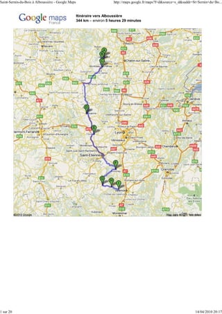
1. Saint-Sernin-du-Bois à Alboussière - Google Maps http://maps.google.fr/maps?f=d&source=s_d&saddr=St+Sernin+du+Bo...
Itinéraire vers Alboussière
344 km – environ 5 heures 29 minutes
1 sur 20 14/04/2010 20:17
2. Saint-Sernin-du-Bois à Alboussière - Google Maps http://maps.google.fr/maps?f=d&source=s_d&saddr=St+Sernin+du+Bo...
Saint-Sernin-du-Bois
1. Prendre la direction sud sur Rue de la Tour 170 m
Total : 170 m
2. Prendre vers D138 complètement à droite 16 m
Total : 190 m
3. Tourner à gauche sur D138 1,9 km
Environ 3 minutes Total : 2,1 km
4. Tourner à droite sur D61/Route du Mesvrin 6,0 km
Continuer de suivre D61 Total : 8,2 km
Environ 7 minutes
2 sur 20 14/04/2010 20:17
3. Saint-Sernin-du-Bois à Alboussière - Google Maps http://maps.google.fr/maps?f=d&source=s_d&saddr=St+Sernin+du+Bo...
5. Tourner à gauche sur N80/Route du Bois de 4,6 km
Ruault Total : 12,8 km
Continuer de suivre N80
Environ 6 minutes
6. Tourner légèrement à droite sur D980 600 m
Environ 1 minute Total : 13,4 km
7. Au rond-point, prendre la 1ère sortie sur D980/Rue 1,1 km
d'Autun Total : 14,5 km
Continuer de suivre D980
Traverser le rond-point
Environ 2 minutes
Total : 14,5 km – environ 18 minutes
Total : 0,0 km
Montcenis
8. Prendre la direction sud-ouest sur D980/Rue des 14 m
Juifs vers D980/Route de Toulon Total : 14 m
3 sur 20 14/04/2010 20:17
4. Saint-Sernin-du-Bois à Alboussière - Google Maps http://maps.google.fr/maps?f=d&source=s_d&saddr=St+Sernin+du+Bo...
9. Tourner à gauche sur D980/Route de Toulon 12,4 km
Continuer de suivre D980 Total : 12,4 km
Environ 12 minutes
Total : 12,4 km – environ 11 minutes
Total : 0,0 km
Blanzy
10. Prendre la direction nord sur D980/Rue Joseph 400 m
Lambert vers D357/Rue Félix Clerc Total : 400 m
Continuer de suivre D980
11. À gauche, prendre la bretelle vers Moulins/ Moulins 270 m
Roanne/Montceau-Centre Roanne Total : 700 m
Montceau-Centre
4 sur 20 14/04/2010 20:17
5. Saint-Sernin-du-Bois à Alboussière - Google Maps http://maps.google.fr/maps?f=d&source=s_d&saddr=St+Sernin+du+Bo...
12. Tourner légèrement à gauche sur N70 33,5 km
Environ 29 minutes Total : 34,2 km
13. Continuer sur N79 9,9 km
Environ 6 minutes Total : 44,1 km
14. Prendre la sortie 23 vers Roanne/Gueugnon/ 23 750 m
Digoin-Centre Total : 44,8 km
Roanne
Environ 1 minute
Gueugnon
Digoin-Centre
15. Au rond-point, prendre la 3e sortie sur D982 en Roanne 7,4 km
direction de Roanne Total : 52,2 km
Environ 7 minutes
5 sur 20 14/04/2010 20:17
6. Saint-Sernin-du-Bois à Alboussière - Google Maps http://maps.google.fr/maps?f=d&source=s_d&saddr=St+Sernin+du+Bo...
16. Tourner à droite sur D982/Route de Marigny 1,8 km
Continuer de suivre D982 Total : 54,0 km
Environ 2 minutes
17. Tourner à droite pour rester sur D982 25,2 km
Radar automatique à 18,5 km Total : 79,2 km
Environ 23 minutes
18. Continuer sur D482 15,3 km
Radar automatique à 6,4 km Total : 94,5 km
Traverser 2 ronds-points
Environ 16 minutes
19. Au rond-point, prendre la 2e sortie sur D482/Rue de 3,5 km
Charlieu Total : 98,0 km
Continuer de suivre Rue de Charlieu
Environ 6 minutes
20. Tourner à gauche sur Avenue Carnot 120 m
Traverser le rond-point Total : 98,1 km
6 sur 20 14/04/2010 20:17
7. Saint-Sernin-du-Bois à Alboussière - Google Maps http://maps.google.fr/maps?f=d&source=s_d&saddr=St+Sernin+du+Bo...
21. Tourner légèrement à gauche sur Rue des 400 m
Aqueducs Total : 98,5 km
Environ 2 minutes
22. Tourner à gauche sur Rue de Cadore 120 m
Total : 98,6 km
Total : 98,6 km – environ 1 heure 35 minutes
Total : 0,0 km
Roanne
23. Prendre la direction nord-est sur Rue Charles de 99 m
Gaulle vers Passage Salengro Total : 99 m
24. Au rond-point, prendre la 1ère sortie sur Place 110 m
Georges Clemenceau Total : 210 m
7 sur 20 14/04/2010 20:17
8. Saint-Sernin-du-Bois à Alboussière - Google Maps http://maps.google.fr/maps?f=d&source=s_d&saddr=St+Sernin+du+Bo...
25. Continuer sur Rue de Fontenille 350 m
Environ 1 minute Total : 550 m
26. Continuer sur Rue de l'Hôpital 300 m
Total : 850 m
27. Tourner à gauche sur Boulevard Bernard Palissy/ 260 m
D482 Total : 1,1 km
Environ 1 minute
28. Tourner à droite sur D482/Rue de Charlieu 700 m
Environ 1 minute Total : 1,8 km
29. À gauche, prendre la bretelle vers Saint- Saint-Etienne 31 m
Etienne/Clermont-Ferrand/Lyon Clermont-Ferrand Total : 1,8 km
Lyon
8 sur 20 14/04/2010 20:17
9. Saint-Sernin-du-Bois à Alboussière - Google Maps http://maps.google.fr/maps?f=d&source=s_d&saddr=St+Sernin+du+Bo...
30. Rester sur la file de droite pour continuer vers N7 et 10,3 km
rejoindre N7 Total : 12,1 km
Environ 7 minutes
31. Continuer sur N82 16,1 km
Environ 11 minutes Total : 28,2 km
32. Tourner légèrement à gauche pour rester sur Balbigny 110 m
N82 (panneaux vers Balbigny/Feurs) Feurs Total : 28,3 km
33. Continuer sur D1082 11,2 km
Traverser 2 ronds-points Total : 39,5 km
Environ 13 minutes
34. Tourner à gauche sur Rue du 8 Mai 9m
Total : 39,5 km
9 sur 20 14/04/2010 20:17
10. Saint-Sernin-du-Bois à Alboussière - Google Maps http://maps.google.fr/maps?f=d&source=s_d&saddr=St+Sernin+du+Bo...
35. Prendre la 1re à droite et rester sur Rue du 8 Mai 350 m
Environ 1 minute Total : 39,9 km
36. Prendre la 2e à droite, puis Rue Gambetta 52 m
Total : 40,0 km
Total : 40,0 km – environ 37 minutes
Total : 0,0 km
Feurs
37. Prendre la direction sud sur Rue Jacquemard vers 140 m
Place Antoine Drivet Total : 140 m
38. Au rond-point, prendre la 1ère sortie sur Thiers 2,7 km
D1089/Rue de la Loire en direction de Thiers/ Clermont-Ferrand Total : 2,9 km
Clermont-Ferrand
Continuer de suivre D1089
Environ 4 minutes
10 sur 20 14/04/2010 20:17
11. Saint-Sernin-du-Bois à Alboussière - Google Maps http://maps.google.fr/maps?f=d&source=s_d&saddr=St+Sernin+du+Bo...
39. À gauche, prendre A72 vers Thiers/Clermont- A72 290 m
Ferrand/Saint-Etienne/Lyon Thiers Total : 3,2 km
Route avec sections à péage Clermont-Ferrand
Environ 1 minute Saint-Etienne
Lyon
40. Rester sur la file de droite pour continuer vers A72 78 m
Route à péage Total : 3,3 km
41. Rester sur la file de gauche et suivre A72/ A72 44,4 km
Saint-Etienne/Lyon pour rejoindre A72 Saint-Etienne Total : 47,6 km
Route avec sections à péage Lyon
Radar automatique à 38,5 km
Environ 25 minutes
42. Prendre la sortie N88 4,3 km
Environ 4 minutes Total : 52,0 km
11 sur 20 14/04/2010 20:17
12. Saint-Sernin-du-Bois à Alboussière - Google Maps http://maps.google.fr/maps?f=d&source=s_d&saddr=St+Sernin+du+Bo...
43. Prendre la sortie 24 vers Annonay 24 90 m
Total : 52,0 km
Annonay
44. Prendre Rue de Granby 93 m
Total : 52,1 km
45. Tourner à gauche sur D1082/Rue Robespierre 30,9 km
Continuer de suivre D1082 Total : 83,0 km
Radar automatique à 20,0 km
Traverser 2 ronds-points
Environ 30 minutes
46. Continuer sur D820 3,0 km
Environ 3 minutes Total : 86,0 km
12 sur 20 14/04/2010 20:17
13. Saint-Sernin-du-Bois à Alboussière - Google Maps http://maps.google.fr/maps?f=d&source=s_d&saddr=St+Sernin+du+Bo...
47. Tourner légèrement à droite sur D206 D206 3,9 km
(panneaux vers D206/Annonay) Annonay Total : 89,9 km
Traverser 2 ronds-points
Environ 5 minutes
48. Tourner à droite sur Avenue Jean Moulin/D206 130 m
Total : 90,1 km
49. Au rond-point, prendre la 1ère sortie sur D206/Rue 350 m
Jean-Joseph Besset Total : 90,4 km
50. Au rond-point, prendre la 3e sortie sur Avenue 200 m
Ferdinand Janvier/D206 Total : 90,6 km
51. Continuer sur Rue Etienne Frachon 350 m
Total : 91,0 km
13 sur 20 14/04/2010 20:17
14. Saint-Sernin-du-Bois à Alboussière - Google Maps http://maps.google.fr/maps?f=d&source=s_d&saddr=St+Sernin+du+Bo...
52. Tourner à gauche pour rester sur Rue Etienne 750 m
Frachon Total : 91,7 km
Environ 1 minute
53. Tourner légèrement à droite sur Rue Eugène 150 m
Melchior de Vogüé Total : 91,9 km
54. Prendre la 2e à gauche et rester sur Rue des 130 m
Fossés du Champ Total : 92,0 km
Environ 1 minute
55. Tourner à gauche sur Rue Franki Kramer 54 m
Total : 92,0 km
Total : 92,0 km – environ 1 heure 17 minutes
Total : 0,0 km
Annonay
14 sur 20 14/04/2010 20:17
15. Saint-Sernin-du-Bois à Alboussière - Google Maps http://maps.google.fr/maps?f=d&source=s_d&saddr=St+Sernin+du+Bo...
56. Prendre la direction ouest sur Rue Franki Kramer 53 m
vers Rue Jean-Baptiste Bechetoille Total : 53 m
57. Continuer sur Rue de l'Hôtel de Ville 110 m
Total : 160 m
58. Continuer sur Rue Boissy d'Anglas/D121 24,9 km
Continuer de suivre D121 Total : 25,1 km
Traverser le rond-point
Environ 25 minutes
59. Continuer sur D105 1,3 km
Environ 1 minute Total : 26,4 km
60. Continuer sur D9 19,2 km
Environ 18 minutes Total : 45,6 km
15 sur 20 14/04/2010 20:17
16. Saint-Sernin-du-Bois à Alboussière - Google Maps http://maps.google.fr/maps?f=d&source=s_d&saddr=St+Sernin+du+Bo...
61. Tourner à droite sur D120/Place de la République 160 m
Continuer de suivre D120 Total : 45,8 km
Environ 1 minute
Total : 45,8 km – environ 45 minutes
Total : 0,0 km
Saint-Agrève
62. Prendre la direction sud-ouest sur D120/Grande 160 m
Rue vers Chemin de la Cabanette Total : 160 m
63. Tourner à gauche pour rester sur D120/Grande 220 m
Rue Total : 400 m
64. Tourner à gauche pour rester sur D120/Grande 150 m
Rue Total : 550 m
16 sur 20 14/04/2010 20:17
17. Saint-Sernin-du-Bois à Alboussière - Google Maps http://maps.google.fr/maps?f=d&source=s_d&saddr=St+Sernin+du+Bo...
65. Tourner à droite sur D120/Rue du Dr Tourasse 350 m
Environ 1 minute Total : 900 m
66. Au rond-point, prendre la 3e sortie sur D533 12,0 km
Environ 11 minutes Total : 12,8 km
67. Tourner à gauche pour rester sur D533 8,2 km
Environ 9 minutes Total : 21,0 km
68. Tourner à gauche sur Place Charles Seignobos 110 m
Total : 21,1 km
69. Tourner à droite sur Place de la République 72 m
Total : 21,2 km
17 sur 20 14/04/2010 20:17
18. Saint-Sernin-du-Bois à Alboussière - Google Maps http://maps.google.fr/maps?f=d&source=s_d&saddr=St+Sernin+du+Bo...
70. Prendre la 1re à gauche et rester sur Place des 34 m
Frères de Montgolfier Total : 21,2 km
Total : 21,2 km – environ 23 minutes
Total : 0,0 km
Lamastre
71. Prendre la direction sud-ouest sur Place des 32 m
Frères de Montgolfier vers Rue Olivier de Serres Total : 32 m
72. Tourner à gauche sur Rue Olivier de Serres 75 m
Total : 110 m
73. Tourner à gauche sur Place Charles Seignobos 110 m
Total : 210 m
18 sur 20 14/04/2010 20:17
19. Saint-Sernin-du-Bois à Alboussière - Google Maps http://maps.google.fr/maps?f=d&source=s_d&saddr=St+Sernin+du+Bo...
74. Tourner à gauche sur D533/Place Charles 2,6 km
Seignobos Total : 2,8 km
Continuer de suivre D533
Environ 3 minutes
75. Tourner à gauche pour rester sur D533 5,1 km
Environ 5 minutes Total : 8,0 km
76. Tourner à gauche pour rester sur D533 4,2 km
Environ 4 minutes Total : 12,2 km
77. Tourner à gauche pour rester sur D533 7,2 km
Environ 7 minutes Total : 19,4 km
78. Tourner à gauche pour rester sur D533 130 m
Total : 19,5 km
Total : 19,5 km – environ 19 minutes
19 sur 20 14/04/2010 20:17