SlideShare a Scribd company logo
1 of 68
Mapping of historical places
        in Japan


        Photo / Tsuruga-jo Castle
Self-introduction


       I'm Ikiya.
       I live in Fukushima, Japan.
       I map Fukushima and East Japan.
       I've mapped Japan and other countris.
       Sorry, my english is not so fluent.


'Where did you contribute to OpenStreetMap? ' http://yosmhm.neis-one.org/?ikiya
I often map towns.
I've also mapped some Volcanos.
                    Azuma_kofuji Volcano
Mapping of Volcanos with my family.
            This is Azuma kofuji Volcano!
                    Altitude 1,707m
'Azuma_kofuji Volcano'


These are my family's GPS logs.
Azuma_kofuji Volcano!
    Altitude 1,707m
After the mapping!!
'Azuma_kofuji Volcano'


      © OpenStreetMap contributors, CC BY-SA
We mapped this Roller Coaster.
My son lode on this.


                  What ?! Dose someone have to
                       this Roller Coaster ?!
           I hope you're not thinking of making me ride it!
These are Roller Coaster Logs.

'Red' > Slowly
'Blue' >>>> Fast >>>>
Mapping of historical places in Japan
I talk about the mapping of historical places in Japan.
It's nice to visit old temples and shrines.
The mapping of historical places in Japan has taught me
much more about the places than had I just visited them
as a tourist.
First,   ZOJOJI                         Buddhist Temple


   ZOJOJI is a famous Buddhist temple
                 in Tokyo.
Mapping of ZOJOJI Log

Walking a lot and recording a lot of points are necessary
for detailed mapping.
Before     Mapping of ZOJOJI


         © OpenStreetMap contributors, CC BY-SA
After   Mapping of ZOJOJI


         © OpenStreetMap contributors, CC BY-SA
YASUKUNI Shrine                 Shinto Shrine


YASUKUNI Shrine is a famous Shinto Shrine .
YASUKUNI Shrine                       Shinto Shrine


YASUKUNI Shrine is in Tokyo near the Imperial Palace
YASUKUNI Shrine                           Shinto Shrine


   Many peoples visit YASUKUNI shrine every year
         to commemorate who died in wars.
Mapping of YASUKUNI Shrine Log


           These are YASUKUNI Shrine Logs.
Before   Mapping of YASUKUNI Shrine


                © OpenStreetMap contributors, CC BY-SA
After   Mapping of YASUKUNI Shrine


                 © OpenStreetMap contributors, CC BY-SA
TSURUGAOKA Shrine                        Shinto Shrine


  TSURUGAOKA Shrine is a famous shinto Shrine too.
TSURUGAOKA Shrine                     Shinto Shrine


    Tsurugaoka shrine is in Kamakura city.
      It's a beautiful place,near the sea.
TSURUGAOKA Shrine   Shinto Shrine
TSURUGAOKA Shrine                              Shinto Shrine


TSURUGAOKA Shrine has about 800 years of history.
TSURUGAOKA Shrine                           Shinto Shrine


      The samurai practiced their religion at this shrine.
Mapping of TSURUGAOKA Shrine Log


         These are TSURUGAOKA Shrine Logs.
Before   Mapping of TSURUGAOKA Shrine


                 © OpenStreetMap contributors, CC BY-SA
After   Mapping of TSURUGAOKA Shrine


                   © OpenStreetMap contributors, CC BY-SA
I love waypoints.
I often use waypoints in mapping
because it is useful for determing-positions.
Waypoints are usually used as mapping markers.
These are Waypoints of Uesugi Shrine.
                                              I love waypoints.


           Uesugi Shrine in Yonezawa city
           (The former site of Yonezawa Castle)
Uesugi Shrine in Yonezawa city
(The former site of Yonezawa Castle)
Uesugi Shrine in Yonezawa city
(The former site of Yonezawa Castle)


   Kenshin Uesugi             Youzan Uesugi
We mapped Uesugi Shrine in Yonezawa City.
Uesugi Shrine in Yonezawa city
After the mapping!!   (The former site of Yonezawa Castle)


                         © OpenStreetMap contributors, CC BY-SA
However, I use them to help record points
that are inaccessible by recording positions
extending beyond those points.


                Building
I use them to help record points that are inaccessible by recording positions
extending beyond those points.


                                     Island
I love waypoints.


waypoints


waypoints
                 Water

    waypoints
I read this book.
I was so grad to find this pege :)
 'Mapping the corner of a building directly (left) or as an intersection(right).


       'Openstreetmap: Using and Enhancing the Free Map of the World'
       /Uit Cambridge Ltd. (2010/09)
Tsuruga-jo Castle                  in Aizu Wakamatsu City


 Next , Tsuruga-jo castle.
 Tsuruga-jo castle is in Aizu Wakamatsu City.
 Aizu Wakamatsu City is in Eastern Japan,
 in the Fukushima Prefecture.
Tsuruga-jo Castle                      in Aizu Wakamatsu City


    Tsuruga-jo castle has about 600 years of history.
Tsuruga-jo Castle                  in Aizu Wakamatsu City


Tsuruga-jo is in the center of Aizu Wakamatsu City.
The castle is surrounded by deep moats and stone walls.
Tsuruga-jo Castle             in Aizu Wakamatsu City


         It's a Stone Wall.
Tsuruga-jo Castle   in Aizu Wakamatsu City
Tsuruga-jo Castle          in Aizu Wakamatsu City


       This building was rebuilt 50 years ago.
Tsuruga-jo Castle          in Aizu Wakamatsu City


          This is a view from the top of the castle.
Mapping of Tsuruga-jo Castle Logs
                 These are Tsuruga-jo Logs.
Mapping of Tsuruga-jo Castle Logs


Now Tsuruga-jo Castle is a Public park.
The outer perimeter of Tsuruga-jo Castle is about 2.5km.
I wanted to map it in detail mapping.
I walked about 23km
around the outer regions of the castle on this day.
Mapping of Tsuruga-jo Castle
Logs
I walked and walked.
I recorded a lot of points.
Before   Mapping of Tsuruga-jo Castle


                © OpenStreetMap contributors, CC BY-SA
After   Mapping of Tsuruga-jo Castle


                  © OpenStreetMap contributors, CC BY-SA
After   Mapping of Tsuruga-jo Castle


                  © OpenStreetMap contributors, CC BY-SA
I had a very scary event .
I was concentrating very deeply about
mapping the castle and walking around to
various places around the castle.
I was walking and mapping on the retaining_wall
that surronds the castle. Let's go map!!
Let's go map!   Walk and Walk!
OH NO!
I was in a dangerous zone.
I noticed that I was standing on a wall behind some
targets that were being used for Japanese Archery.
Some pepole were practicing Archery.


 Training field
 for Archery.


                                 © OpenStreetMap contributors, CC BY-SA
Let's go map!
Historical places in Japan are beautiful and wonderful.
     Please enjoy exploring geo and time space in Japan!!
Thank you !


   State of the Map 2012
   Tokyo,Japan,September 2012

More Related Content

Viewers also liked (6)

English as an International Language in Japan
English as an International Language in JapanEnglish as an International Language in Japan
English as an International Language in Japan
 
Life in Japan
Life in JapanLife in Japan
Life in Japan
 
Religion in japan
Religion in japanReligion in japan
Religion in japan
 
History of japan
History of japanHistory of japan
History of japan
 
Travel Tips Learned from Japan! - #japan #traveltips
Travel Tips Learned from Japan! - #japan #traveltipsTravel Tips Learned from Japan! - #japan #traveltips
Travel Tips Learned from Japan! - #japan #traveltips
 
LinkedIn SlideShare: Knowledge, Well-Presented
LinkedIn SlideShare: Knowledge, Well-PresentedLinkedIn SlideShare: Knowledge, Well-Presented
LinkedIn SlideShare: Knowledge, Well-Presented
 

Similar to Mapping of historical places in Japan

Asakusa (taito) MAP
Asakusa (taito) MAPAsakusa (taito) MAP
Asakusa (taito) MAP
Camy333
 
Japan Travel Profile
Japan Travel ProfileJapan Travel Profile
Japan Travel Profile
Zoe Bligh
 

Similar to Mapping of historical places in Japan (9)

Mapping of Historical Sties in Japan
Mapping of Historical Sties in JapanMapping of Historical Sties in Japan
Mapping of Historical Sties in Japan
 
Asakusa (taito) MAP
Asakusa (taito) MAPAsakusa (taito) MAP
Asakusa (taito) MAP
 
7 Top-Rated Tourist Attractions in Japan ic Travel.pdf
7 Top-Rated Tourist Attractions in Japan ic Travel.pdf7 Top-Rated Tourist Attractions in Japan ic Travel.pdf
7 Top-Rated Tourist Attractions in Japan ic Travel.pdf
 
Japan Travel Profile
Japan Travel ProfileJapan Travel Profile
Japan Travel Profile
 
Kumamoto photo spot
Kumamoto photo spotKumamoto photo spot
Kumamoto photo spot
 
Introduction to maniwa Eng
Introduction to maniwa EngIntroduction to maniwa Eng
Introduction to maniwa Eng
 
Travels from Tokyo to Kyoto and beyond
Travels from Tokyo to Kyoto and beyondTravels from Tokyo to Kyoto and beyond
Travels from Tokyo to Kyoto and beyond
 
Nowhere But Niigata
Nowhere But NiigataNowhere But Niigata
Nowhere But Niigata
 
Osaka and kyoto travelling itinerary guide
Osaka and kyoto travelling itinerary guideOsaka and kyoto travelling itinerary guide
Osaka and kyoto travelling itinerary guide
 

More from ikiya_OSM (7)

Holding State of the Map in local cities / SotM2017Aizu
Holding State of the Map in local cities / SotM2017AizuHolding State of the Map in local cities / SotM2017Aizu
Holding State of the Map in local cities / SotM2017Aizu
 
The State of Fukushima 2015
The State of Fukushima 2015The State of Fukushima 2015
The State of Fukushima 2015
 
Mapillaryなgeoスポット
MapillaryなgeoスポットMapillaryなgeoスポット
Mapillaryなgeoスポット
 
The State of Fukushima, Japan
The State of Fukushima, Japan The State of Fukushima, Japan
The State of Fukushima, Japan
 
What does the future hold for traditional style mappers? OSMマッパーの未来は?
What does the future hold for traditional style mappers? OSMマッパーの未来は?What does the future hold for traditional style mappers? OSMマッパーの未来は?
What does the future hold for traditional style mappers? OSMマッパーの未来は?
 
What does the future hold for traditional style mappers?
What does the future hold for traditional style mappers?What does the future hold for traditional style mappers?
What does the future hold for traditional style mappers?
 
Fukushima mapping Before and after the disaster
Fukushima mapping  Before and after the disasterFukushima mapping  Before and after the disaster
Fukushima mapping Before and after the disaster
 

Recently uploaded

Why Teams call analytics are critical to your entire business
Why Teams call analytics are critical to your entire businessWhy Teams call analytics are critical to your entire business
Why Teams call analytics are critical to your entire business
panagenda
 

Recently uploaded (20)

presentation ICT roal in 21st century education
presentation ICT roal in 21st century educationpresentation ICT roal in 21st century education
presentation ICT roal in 21st century education
 
Why Teams call analytics are critical to your entire business
Why Teams call analytics are critical to your entire businessWhy Teams call analytics are critical to your entire business
Why Teams call analytics are critical to your entire business
 
Boost Fertility New Invention Ups Success Rates.pdf
Boost Fertility New Invention Ups Success Rates.pdfBoost Fertility New Invention Ups Success Rates.pdf
Boost Fertility New Invention Ups Success Rates.pdf
 
Biography Of Angeliki Cooney | Senior Vice President Life Sciences | Albany, ...
Biography Of Angeliki Cooney | Senior Vice President Life Sciences | Albany, ...Biography Of Angeliki Cooney | Senior Vice President Life Sciences | Albany, ...
Biography Of Angeliki Cooney | Senior Vice President Life Sciences | Albany, ...
 
Mcleodganj Call Girls 🥰 8617370543 Service Offer VIP Hot Model
Mcleodganj Call Girls 🥰 8617370543 Service Offer VIP Hot ModelMcleodganj Call Girls 🥰 8617370543 Service Offer VIP Hot Model
Mcleodganj Call Girls 🥰 8617370543 Service Offer VIP Hot Model
 
[BuildWithAI] Introduction to Gemini.pdf
[BuildWithAI] Introduction to Gemini.pdf[BuildWithAI] Introduction to Gemini.pdf
[BuildWithAI] Introduction to Gemini.pdf
 
"I see eyes in my soup": How Delivery Hero implemented the safety system for ...
"I see eyes in my soup": How Delivery Hero implemented the safety system for ..."I see eyes in my soup": How Delivery Hero implemented the safety system for ...
"I see eyes in my soup": How Delivery Hero implemented the safety system for ...
 
Polkadot JAM Slides - Token2049 - By Dr. Gavin Wood
Polkadot JAM Slides - Token2049 - By Dr. Gavin WoodPolkadot JAM Slides - Token2049 - By Dr. Gavin Wood
Polkadot JAM Slides - Token2049 - By Dr. Gavin Wood
 
Strategize a Smooth Tenant-to-tenant Migration and Copilot Takeoff
Strategize a Smooth Tenant-to-tenant Migration and Copilot TakeoffStrategize a Smooth Tenant-to-tenant Migration and Copilot Takeoff
Strategize a Smooth Tenant-to-tenant Migration and Copilot Takeoff
 
Apidays New York 2024 - Passkeys: Developing APIs to enable passwordless auth...
Apidays New York 2024 - Passkeys: Developing APIs to enable passwordless auth...Apidays New York 2024 - Passkeys: Developing APIs to enable passwordless auth...
Apidays New York 2024 - Passkeys: Developing APIs to enable passwordless auth...
 
WSO2's API Vision: Unifying Control, Empowering Developers
WSO2's API Vision: Unifying Control, Empowering DevelopersWSO2's API Vision: Unifying Control, Empowering Developers
WSO2's API Vision: Unifying Control, Empowering Developers
 
Platformless Horizons for Digital Adaptability
Platformless Horizons for Digital AdaptabilityPlatformless Horizons for Digital Adaptability
Platformless Horizons for Digital Adaptability
 
Exploring Multimodal Embeddings with Milvus
Exploring Multimodal Embeddings with MilvusExploring Multimodal Embeddings with Milvus
Exploring Multimodal Embeddings with Milvus
 
EMPOWERMENT TECHNOLOGY GRADE 11 QUARTER 2 REVIEWER
EMPOWERMENT TECHNOLOGY GRADE 11 QUARTER 2 REVIEWEREMPOWERMENT TECHNOLOGY GRADE 11 QUARTER 2 REVIEWER
EMPOWERMENT TECHNOLOGY GRADE 11 QUARTER 2 REVIEWER
 
Apidays New York 2024 - Scaling API-first by Ian Reasor and Radu Cotescu, Adobe
Apidays New York 2024 - Scaling API-first by Ian Reasor and Radu Cotescu, AdobeApidays New York 2024 - Scaling API-first by Ian Reasor and Radu Cotescu, Adobe
Apidays New York 2024 - Scaling API-first by Ian Reasor and Radu Cotescu, Adobe
 
TrustArc Webinar - Unlock the Power of AI-Driven Data Discovery
TrustArc Webinar - Unlock the Power of AI-Driven Data DiscoveryTrustArc Webinar - Unlock the Power of AI-Driven Data Discovery
TrustArc Webinar - Unlock the Power of AI-Driven Data Discovery
 
MS Copilot expands with MS Graph connectors
MS Copilot expands with MS Graph connectorsMS Copilot expands with MS Graph connectors
MS Copilot expands with MS Graph connectors
 
CNIC Information System with Pakdata Cf In Pakistan
CNIC Information System with Pakdata Cf In PakistanCNIC Information System with Pakdata Cf In Pakistan
CNIC Information System with Pakdata Cf In Pakistan
 
DEV meet-up UiPath Document Understanding May 7 2024 Amsterdam
DEV meet-up UiPath Document Understanding May 7 2024 AmsterdamDEV meet-up UiPath Document Understanding May 7 2024 Amsterdam
DEV meet-up UiPath Document Understanding May 7 2024 Amsterdam
 
Apidays New York 2024 - The value of a flexible API Management solution for O...
Apidays New York 2024 - The value of a flexible API Management solution for O...Apidays New York 2024 - The value of a flexible API Management solution for O...
Apidays New York 2024 - The value of a flexible API Management solution for O...
 

Mapping of historical places in Japan

  • 1. Mapping of historical places in Japan Photo / Tsuruga-jo Castle
  • 2. Self-introduction I'm Ikiya. I live in Fukushima, Japan. I map Fukushima and East Japan. I've mapped Japan and other countris. Sorry, my english is not so fluent. 'Where did you contribute to OpenStreetMap? ' http://yosmhm.neis-one.org/?ikiya
  • 3. I often map towns.
  • 4. I've also mapped some Volcanos. Azuma_kofuji Volcano
  • 5. Mapping of Volcanos with my family. This is Azuma kofuji Volcano! Altitude 1,707m
  • 6. 'Azuma_kofuji Volcano' These are my family's GPS logs.
  • 7. Azuma_kofuji Volcano! Altitude 1,707m
  • 8. After the mapping!! 'Azuma_kofuji Volcano' © OpenStreetMap contributors, CC BY-SA
  • 9. We mapped this Roller Coaster.
  • 10. My son lode on this. What ?! Dose someone have to this Roller Coaster ?! I hope you're not thinking of making me ride it!
  • 11. These are Roller Coaster Logs. 'Red' > Slowly 'Blue' >>>> Fast >>>>
  • 12. Mapping of historical places in Japan
  • 13. I talk about the mapping of historical places in Japan. It's nice to visit old temples and shrines.
  • 14. The mapping of historical places in Japan has taught me much more about the places than had I just visited them as a tourist.
  • 15. First, ZOJOJI Buddhist Temple ZOJOJI is a famous Buddhist temple in Tokyo.
  • 16. Mapping of ZOJOJI Log Walking a lot and recording a lot of points are necessary for detailed mapping.
  • 17. Before Mapping of ZOJOJI © OpenStreetMap contributors, CC BY-SA
  • 18. After Mapping of ZOJOJI © OpenStreetMap contributors, CC BY-SA
  • 19. YASUKUNI Shrine Shinto Shrine YASUKUNI Shrine is a famous Shinto Shrine .
  • 20. YASUKUNI Shrine Shinto Shrine YASUKUNI Shrine is in Tokyo near the Imperial Palace
  • 21. YASUKUNI Shrine Shinto Shrine Many peoples visit YASUKUNI shrine every year to commemorate who died in wars.
  • 22. Mapping of YASUKUNI Shrine Log These are YASUKUNI Shrine Logs.
  • 23. Before Mapping of YASUKUNI Shrine © OpenStreetMap contributors, CC BY-SA
  • 24. After Mapping of YASUKUNI Shrine © OpenStreetMap contributors, CC BY-SA
  • 25. TSURUGAOKA Shrine Shinto Shrine TSURUGAOKA Shrine is a famous shinto Shrine too.
  • 26. TSURUGAOKA Shrine Shinto Shrine Tsurugaoka shrine is in Kamakura city. It's a beautiful place,near the sea.
  • 27. TSURUGAOKA Shrine Shinto Shrine
  • 28. TSURUGAOKA Shrine Shinto Shrine TSURUGAOKA Shrine has about 800 years of history.
  • 29. TSURUGAOKA Shrine Shinto Shrine The samurai practiced their religion at this shrine.
  • 30. Mapping of TSURUGAOKA Shrine Log These are TSURUGAOKA Shrine Logs.
  • 31. Before Mapping of TSURUGAOKA Shrine © OpenStreetMap contributors, CC BY-SA
  • 32. After Mapping of TSURUGAOKA Shrine © OpenStreetMap contributors, CC BY-SA
  • 34. I often use waypoints in mapping because it is useful for determing-positions.
  • 35. Waypoints are usually used as mapping markers.
  • 36. These are Waypoints of Uesugi Shrine. I love waypoints. Uesugi Shrine in Yonezawa city (The former site of Yonezawa Castle)
  • 37. Uesugi Shrine in Yonezawa city (The former site of Yonezawa Castle)
  • 38. Uesugi Shrine in Yonezawa city (The former site of Yonezawa Castle) Kenshin Uesugi Youzan Uesugi
  • 39. We mapped Uesugi Shrine in Yonezawa City.
  • 40. Uesugi Shrine in Yonezawa city After the mapping!! (The former site of Yonezawa Castle) © OpenStreetMap contributors, CC BY-SA
  • 41. However, I use them to help record points that are inaccessible by recording positions extending beyond those points. Building
  • 42. I use them to help record points that are inaccessible by recording positions extending beyond those points. Island
  • 44. I read this book. I was so grad to find this pege :) 'Mapping the corner of a building directly (left) or as an intersection(right). 'Openstreetmap: Using and Enhancing the Free Map of the World' /Uit Cambridge Ltd. (2010/09)
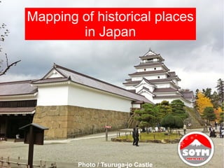
  • 45. Tsuruga-jo Castle in Aizu Wakamatsu City Next , Tsuruga-jo castle. Tsuruga-jo castle is in Aizu Wakamatsu City. Aizu Wakamatsu City is in Eastern Japan, in the Fukushima Prefecture.
  • 46. Tsuruga-jo Castle in Aizu Wakamatsu City Tsuruga-jo castle has about 600 years of history.
  • 47. Tsuruga-jo Castle in Aizu Wakamatsu City Tsuruga-jo is in the center of Aizu Wakamatsu City. The castle is surrounded by deep moats and stone walls.
  • 48. Tsuruga-jo Castle in Aizu Wakamatsu City It's a Stone Wall.
  • 49. Tsuruga-jo Castle in Aizu Wakamatsu City
  • 50. Tsuruga-jo Castle in Aizu Wakamatsu City This building was rebuilt 50 years ago.
  • 51. Tsuruga-jo Castle in Aizu Wakamatsu City This is a view from the top of the castle.
  • 52. Mapping of Tsuruga-jo Castle Logs These are Tsuruga-jo Logs.
  • 53. Mapping of Tsuruga-jo Castle Logs Now Tsuruga-jo Castle is a Public park. The outer perimeter of Tsuruga-jo Castle is about 2.5km. I wanted to map it in detail mapping. I walked about 23km around the outer regions of the castle on this day.
  • 54. Mapping of Tsuruga-jo Castle Logs
  • 55. I walked and walked.
  • 56. I recorded a lot of points.
  • 57. Before Mapping of Tsuruga-jo Castle © OpenStreetMap contributors, CC BY-SA
  • 58. After Mapping of Tsuruga-jo Castle © OpenStreetMap contributors, CC BY-SA
  • 59. After Mapping of Tsuruga-jo Castle © OpenStreetMap contributors, CC BY-SA
  • 60. I had a very scary event . I was concentrating very deeply about mapping the castle and walking around to various places around the castle.
  • 61. I was walking and mapping on the retaining_wall that surronds the castle. Let's go map!!
  • 62. Let's go map! Walk and Walk!
  • 63. Let's go map! Walk and Walk!
  • 64. OH NO! I was in a dangerous zone.
  • 65. I noticed that I was standing on a wall behind some targets that were being used for Japanese Archery. Some pepole were practicing Archery. Training field for Archery. © OpenStreetMap contributors, CC BY-SA
  • 67. Historical places in Japan are beautiful and wonderful. Please enjoy exploring geo and time space in Japan!!
  • 68. Thank you ! State of the Map 2012 Tokyo,Japan,September 2012