SlideShare une entreprise Scribd logo
1  sur  9
Télécharger pour lire hors ligne
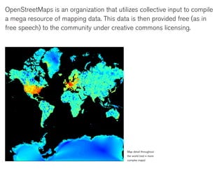
OpenStreetMaps is an organization that utilizes collective input to compile
a mega resource of mapping data. This data is then provided free (as in
free speech) to the community under creative commons licensing.


                                            Map detail throughout
                                            the world (red = more
                                            complex maps)
The overriding goal of the project is to map the entire world with data
provided by people who take to the streets, trails and back roads equipped
with a gps device, or simply a pencil and paper. This low cost, bottom-up
approach will lead to increasingly nuanced global geo data set.


                                                     Map showing parts
                                                     of London that have
                                                     been updated in the
                                                     last year (from OSM
                                                     Mapper)
OSM was founded in 2004 with a fairly large blank canvas: the globe.

As of September 2009 they now have enlisted over 140,000 users.
Though there is still much further to go, a quick look around the world map
on OSM’s home page reveals how much data has been collected within
the past 6 years.


                                                            screenshot from osm
                                                            home page.
WHY

The most common question heard in response to their mission is “why not
just use google maps.” As we have learned over the past few weeks, the
distinction is that with google we are given “free beer.” You can only use
their interface and their system. You cannot fix mistakes, and you cannot
contribute new data.

Also, goggle is licensing their data from the dominant geo data companies
like tele atlas and navteq. These companies levy heavy fees for narrowly
defined licenses in order to maximize market share, which creates a
buffer against potential grass roots initiatives.
The flexibility of OSM’s open source approach makes it an ideal option for
applications that are based on geographical data. If you have an iPhone
and you like mapping apps, chances are you will have an app that utilizes
data from OSM. A few examples are OpenCycleMap and OpenMaps and
Roadee.


                                           a few images from
                                           Roadee
And in the same way wikipedia produces better quality encyclopedic
reference through peer review and editing, open source geo data makes
more reliable and user specific maps. When someone takes the initiative
to go out with their gps device they are typically going to be extra
careful to add the local nuances to their mapping efforts. Cycle maps,
for example, could include info on bike shop locations, bike parking, (un)
official bike routes, and even degree incline of streets.


                                          The cycle map-now
                                          has hill-shading
HOW
For content users there are two ways to utilize this amazing resource. For one, you can simply use the available interfaces
running with OSM data. Visit their homepage and simply start browsing. Clicking around you will see that the interface relates to
most other map browsers.

There are tutorials available on their wiki page that explain how to go deeper and actually begin contributing to the map data. It
seems easiest to use a gps device, which are fairly inexpensive these days. But if you desire, you can go old school recording
data with pencil and paper.

The most empowering aspect of this collective resource is that up-to-the-minute data sets can be accessed by anyone for
almost any use. Maybe someone has a new idea for developing interface, or a complex geo info graphic, or needs mapping data
to enhance an emergency humanitarian effort. All of this is made possible with OSM’s flexibly licensed geo data along side their
use of development friendly open sourced code.


                                           Nothing left to map?
                                           Try underground
                                           pipelines, deduced
                                           from manholes, wall
                                           markers and open pit
                                           construction work.
INSPIRING EXAMPLES

The recent earthquakes in Haiti and Chile elicited an immediate response
from the OSM community of developer. Using low cost measures they
were able to offer a few different platforms for people on the ground
there to access vital data update by the day.


                                                    Example zoomed in
                                                    area of http://haiti.
                                                    openstreetmap.nl/
                                                    The Haiti custom
                                                    rendering set up
                                                    by User:Ldp which
                                                    shows damaged
                                                    buildings and refugee
                                                    camps mapped within
                                                    OpenStreetMap using
                                                    specialv
Of interest to me is OpenStreetView which is trying to map with open
sourced street level photography. Seem like they have a ways to go, but I
find the possibility of mapping my immediate area quite interesting.


                                                               OpenstreetView
                                                               homepage

Contenu connexe

Tendances

shift2010 - 17apr2010 - OpenStreetMap: a free map for our world
shift2010 - 17apr2010 - OpenStreetMap: a free map for our worldshift2010 - 17apr2010 - OpenStreetMap: a free map for our world
shift2010 - 17apr2010 - OpenStreetMap: a free map for our worldSimone Cortesi
 
Open street map final ppt
Open street map final pptOpen street map final ppt
Open street map final pptPrashant Menon
 
Leeds Data Thing OpenStreetMap and Other Geo Visualization Stuff
Leeds Data Thing OpenStreetMap and Other Geo Visualization StuffLeeds Data Thing OpenStreetMap and Other Geo Visualization Stuff
Leeds Data Thing OpenStreetMap and Other Geo Visualization Stuffchippy
 
Osm application
Osm applicationOsm application
Osm applicationQust04
 
OpenStreetMap : Open Licensed GeoData
OpenStreetMap : Open Licensed GeoDataOpenStreetMap : Open Licensed GeoData
OpenStreetMap : Open Licensed GeoDataHarry Wood
 
An introduction to OpenStreetMap for bushwalkers
An introduction to OpenStreetMap for bushwalkersAn introduction to OpenStreetMap for bushwalkers
An introduction to OpenStreetMap for bushwalkersdbdean
 
Introduction to OpenStreetMap
Introduction to OpenStreetMapIntroduction to OpenStreetMap
Introduction to OpenStreetMapdbdean
 
An Introduction to OpenStreetMap (UQ GIS Students)
An Introduction to OpenStreetMap (UQ GIS Students)An Introduction to OpenStreetMap (UQ GIS Students)
An Introduction to OpenStreetMap (UQ GIS Students)dbdean
 
JRC OpenStreetMap, editing and tasking mechanisms, 20130326
JRC OpenStreetMap, editing and tasking mechanisms, 20130326JRC OpenStreetMap, editing and tasking mechanisms, 20130326
JRC OpenStreetMap, editing and tasking mechanisms, 20130326Severin Menard
 
H.O.T at UNGIWG 10
H.O.T at UNGIWG 10H.O.T at UNGIWG 10
H.O.T at UNGIWG 10mikel_maron
 
OpenStreetMap-Introduction
OpenStreetMap-IntroductionOpenStreetMap-Introduction
OpenStreetMap-IntroductionPhilippe Rieffel
 
Eurosha kenya pres_osm_en_20121031
Eurosha kenya pres_osm_en_20121031Eurosha kenya pres_osm_en_20121031
Eurosha kenya pres_osm_en_20121031Severin Menard
 
How Crowdsourcing Changed Disaster Relief Forever (Web 2.0 Summit Ignite vers...
How Crowdsourcing Changed Disaster Relief Forever (Web 2.0 Summit Ignite vers...How Crowdsourcing Changed Disaster Relief Forever (Web 2.0 Summit Ignite vers...
How Crowdsourcing Changed Disaster Relief Forever (Web 2.0 Summit Ignite vers...Schuyler Erle
 
Ieee 2014 tech_training_open_streetmap_20121011
Ieee 2014 tech_training_open_streetmap_20121011Ieee 2014 tech_training_open_streetmap_20121011
Ieee 2014 tech_training_open_streetmap_20121011ALCE Samuel Paul
 
HOT OSM Community mapping in Lower Shire, Malawi
HOT OSM Community mapping in Lower Shire, MalawiHOT OSM Community mapping in Lower Shire, Malawi
HOT OSM Community mapping in Lower Shire, MalawiSeverin Menard
 
Haiti HOT OSM éducation 15/02/2012 (FR)
Haiti HOT OSM éducation 15/02/2012 (FR)Haiti HOT OSM éducation 15/02/2012 (FR)
Haiti HOT OSM éducation 15/02/2012 (FR)Severin Menard
 
Introduction to OpenStreetMap, its extracts, and relation to Project NOAH
Introduction to OpenStreetMap, its extracts, and relation to Project NOAHIntroduction to OpenStreetMap, its extracts, and relation to Project NOAH
Introduction to OpenStreetMap, its extracts, and relation to Project NOAHErvin Malicdem
 
Openstreetmap and its value during emergencies
Openstreetmap and its value during emergenciesOpenstreetmap and its value during emergencies
Openstreetmap and its value during emergenciesErvin Malicdem
 
Modified Resource Google Presentation
Modified Resource Google PresentationModified Resource Google Presentation
Modified Resource Google PresentationWilliam Worford
 
Open streetmap response-to-ebola-crisis-geong-2014-09-23
Open streetmap response-to-ebola-crisis-geong-2014-09-23Open streetmap response-to-ebola-crisis-geong-2014-09-23
Open streetmap response-to-ebola-crisis-geong-2014-09-23Pierre Béland
 

Tendances (20)

shift2010 - 17apr2010 - OpenStreetMap: a free map for our world
shift2010 - 17apr2010 - OpenStreetMap: a free map for our worldshift2010 - 17apr2010 - OpenStreetMap: a free map for our world
shift2010 - 17apr2010 - OpenStreetMap: a free map for our world
 
Open street map final ppt
Open street map final pptOpen street map final ppt
Open street map final ppt
 
Leeds Data Thing OpenStreetMap and Other Geo Visualization Stuff
Leeds Data Thing OpenStreetMap and Other Geo Visualization StuffLeeds Data Thing OpenStreetMap and Other Geo Visualization Stuff
Leeds Data Thing OpenStreetMap and Other Geo Visualization Stuff
 
Osm application
Osm applicationOsm application
Osm application
 
OpenStreetMap : Open Licensed GeoData
OpenStreetMap : Open Licensed GeoDataOpenStreetMap : Open Licensed GeoData
OpenStreetMap : Open Licensed GeoData
 
An introduction to OpenStreetMap for bushwalkers
An introduction to OpenStreetMap for bushwalkersAn introduction to OpenStreetMap for bushwalkers
An introduction to OpenStreetMap for bushwalkers
 
Introduction to OpenStreetMap
Introduction to OpenStreetMapIntroduction to OpenStreetMap
Introduction to OpenStreetMap
 
An Introduction to OpenStreetMap (UQ GIS Students)
An Introduction to OpenStreetMap (UQ GIS Students)An Introduction to OpenStreetMap (UQ GIS Students)
An Introduction to OpenStreetMap (UQ GIS Students)
 
JRC OpenStreetMap, editing and tasking mechanisms, 20130326
JRC OpenStreetMap, editing and tasking mechanisms, 20130326JRC OpenStreetMap, editing and tasking mechanisms, 20130326
JRC OpenStreetMap, editing and tasking mechanisms, 20130326
 
H.O.T at UNGIWG 10
H.O.T at UNGIWG 10H.O.T at UNGIWG 10
H.O.T at UNGIWG 10
 
OpenStreetMap-Introduction
OpenStreetMap-IntroductionOpenStreetMap-Introduction
OpenStreetMap-Introduction
 
Eurosha kenya pres_osm_en_20121031
Eurosha kenya pres_osm_en_20121031Eurosha kenya pres_osm_en_20121031
Eurosha kenya pres_osm_en_20121031
 
How Crowdsourcing Changed Disaster Relief Forever (Web 2.0 Summit Ignite vers...
How Crowdsourcing Changed Disaster Relief Forever (Web 2.0 Summit Ignite vers...How Crowdsourcing Changed Disaster Relief Forever (Web 2.0 Summit Ignite vers...
How Crowdsourcing Changed Disaster Relief Forever (Web 2.0 Summit Ignite vers...
 
Ieee 2014 tech_training_open_streetmap_20121011
Ieee 2014 tech_training_open_streetmap_20121011Ieee 2014 tech_training_open_streetmap_20121011
Ieee 2014 tech_training_open_streetmap_20121011
 
HOT OSM Community mapping in Lower Shire, Malawi
HOT OSM Community mapping in Lower Shire, MalawiHOT OSM Community mapping in Lower Shire, Malawi
HOT OSM Community mapping in Lower Shire, Malawi
 
Haiti HOT OSM éducation 15/02/2012 (FR)
Haiti HOT OSM éducation 15/02/2012 (FR)Haiti HOT OSM éducation 15/02/2012 (FR)
Haiti HOT OSM éducation 15/02/2012 (FR)
 
Introduction to OpenStreetMap, its extracts, and relation to Project NOAH
Introduction to OpenStreetMap, its extracts, and relation to Project NOAHIntroduction to OpenStreetMap, its extracts, and relation to Project NOAH
Introduction to OpenStreetMap, its extracts, and relation to Project NOAH
 
Openstreetmap and its value during emergencies
Openstreetmap and its value during emergenciesOpenstreetmap and its value during emergencies
Openstreetmap and its value during emergencies
 
Modified Resource Google Presentation
Modified Resource Google PresentationModified Resource Google Presentation
Modified Resource Google Presentation
 
Open streetmap response-to-ebola-crisis-geong-2014-09-23
Open streetmap response-to-ebola-crisis-geong-2014-09-23Open streetmap response-to-ebola-crisis-geong-2014-09-23
Open streetmap response-to-ebola-crisis-geong-2014-09-23
 

En vedette

Bullying
BullyingBullying
BullyingEriko
 
What is Social Media [board] FINAL
What is Social Media [board] FINALWhat is Social Media [board] FINAL
What is Social Media [board] FINALAGroggel
 
Trabajo De Ingles
Trabajo De InglesTrabajo De Ingles
Trabajo De Inglesjuancalad
 
Photo Essay: Carson Falls, Marin Co., California
Photo Essay: Carson Falls, Marin Co., CaliforniaPhoto Essay: Carson Falls, Marin Co., California
Photo Essay: Carson Falls, Marin Co., CaliforniaAGroggel
 
LinkedIn presentation for ProNet
LinkedIn presentation for ProNetLinkedIn presentation for ProNet
LinkedIn presentation for ProNetJason Tarazi
 
PHP training by Arrays Technosys
PHP training by Arrays TechnosysPHP training by Arrays Technosys
PHP training by Arrays TechnosysArrays Technosys
 

En vedette (6)

Bullying
BullyingBullying
Bullying
 
What is Social Media [board] FINAL
What is Social Media [board] FINALWhat is Social Media [board] FINAL
What is Social Media [board] FINAL
 
Trabajo De Ingles
Trabajo De InglesTrabajo De Ingles
Trabajo De Ingles
 
Photo Essay: Carson Falls, Marin Co., California
Photo Essay: Carson Falls, Marin Co., CaliforniaPhoto Essay: Carson Falls, Marin Co., California
Photo Essay: Carson Falls, Marin Co., California
 
LinkedIn presentation for ProNet
LinkedIn presentation for ProNetLinkedIn presentation for ProNet
LinkedIn presentation for ProNet
 
PHP training by Arrays Technosys
PHP training by Arrays TechnosysPHP training by Arrays Technosys
PHP training by Arrays Technosys
 

Similaire à Osm Presentation

OpenStreetMap and CycleStreets: collaborative map-making and cartography in t...
OpenStreetMap and CycleStreets: collaborative map-making and cartography in t...OpenStreetMap and CycleStreets: collaborative map-making and cartography in t...
OpenStreetMap and CycleStreets: collaborative map-making and cartography in t...CycleStreets
 
Humanitarian OpenStreetMap Team [H.O.T.] Training for SBTF
Humanitarian OpenStreetMap Team [H.O.T.] Training for SBTFHumanitarian OpenStreetMap Team [H.O.T.] Training for SBTF
Humanitarian OpenStreetMap Team [H.O.T.] Training for SBTFStandby Task Force
 
Volunteered Geographic Information and OpenStreetMap
Volunteered Geographic Information and OpenStreetMapVolunteered Geographic Information and OpenStreetMap
Volunteered Geographic Information and OpenStreetMapchippy
 
OpenStreetMap at Where2.0Now
OpenStreetMap at Where2.0NowOpenStreetMap at Where2.0Now
OpenStreetMap at Where2.0NowHarry Wood
 
Talk: "Using Open Data and Crowdsourcing to develop CycleStreets"
Talk: "Using Open Data and Crowdsourcing to develop CycleStreets"Talk: "Using Open Data and Crowdsourcing to develop CycleStreets"
Talk: "Using Open Data and Crowdsourcing to develop CycleStreets"CycleStreets
 
OpenStreetMap at Wikimania
OpenStreetMap at WikimaniaOpenStreetMap at Wikimania
OpenStreetMap at Wikimaniamikel_maron
 
OpenStreetMap OpenTech 2011
OpenStreetMap OpenTech 2011OpenStreetMap OpenTech 2011
OpenStreetMap OpenTech 2011Harry Wood
 
Crowdsourced mapping for open collaboration: A story of Taiwan so far
Crowdsourced mapping for open collaboration: A story of Taiwan so farCrowdsourced mapping for open collaboration: A story of Taiwan so far
Crowdsourced mapping for open collaboration: A story of Taiwan so farDongpo Deng
 
Introduction to OpenStreetMap and Humanitarian OSM Team for Plan Internationa...
Introduction to OpenStreetMap and Humanitarian OSM Team for Plan Internationa...Introduction to OpenStreetMap and Humanitarian OSM Team for Plan Internationa...
Introduction to OpenStreetMap and Humanitarian OSM Team for Plan Internationa...chippy
 
MapQuest: How OSM Benefits & Vice Versa
MapQuest: How OSM Benefits & Vice VersaMapQuest: How OSM Benefits & Vice Versa
MapQuest: How OSM Benefits & Vice VersaRandy Meech
 
Openstreetmap presentation of Mapping Party at FSMK camp
Openstreetmap presentation of Mapping Party at FSMK campOpenstreetmap presentation of Mapping Party at FSMK camp
Openstreetmap presentation of Mapping Party at FSMK campYogesh Ks
 
Tokyo April 2008 Openstreetmap
Tokyo April 2008 OpenstreetmapTokyo April 2008 Openstreetmap
Tokyo April 2008 Openstreetmapchippy
 
The Gorbals in Relief: Experiments in OpenStreetMap and Architectural Practic...
The Gorbals in Relief: Experiments in OpenStreetMap and Architectural Practic...The Gorbals in Relief: Experiments in OpenStreetMap and Architectural Practic...
The Gorbals in Relief: Experiments in OpenStreetMap and Architectural Practic...duncanbain
 
Philippine Geospatial Forum Presentation 20130311
Philippine Geospatial Forum Presentation 20130311Philippine Geospatial Forum Presentation 20130311
Philippine Geospatial Forum Presentation 20130311esambale
 
Mobile Social Location (Web 2.0 NYC edition)
Mobile Social Location (Web 2.0 NYC edition)Mobile Social Location (Web 2.0 NYC edition)
Mobile Social Location (Web 2.0 NYC edition)Matt Biddulph
 
II-SDV 2015, 21 - 21 April, in Nice
II-SDV 2015, 21 - 21 April, in NiceII-SDV 2015, 21 - 21 April, in Nice
II-SDV 2015, 21 - 21 April, in NiceDr. Haxel Consult
 
From a niche to a global user community: Open Source GIS and OSGeo
From a niche to a global user community: Open Source GIS and OSGeoFrom a niche to a global user community: Open Source GIS and OSGeo
From a niche to a global user community: Open Source GIS and OSGeoMarkus Neteler
 
NEARC 2009 CUNY Mapping Service
NEARC 2009 CUNY Mapping ServiceNEARC 2009 CUNY Mapping Service
NEARC 2009 CUNY Mapping Servicesromalewski
 

Similaire à Osm Presentation (20)

OSM HOT SBTF 2013_03_16
OSM HOT SBTF 2013_03_16OSM HOT SBTF 2013_03_16
OSM HOT SBTF 2013_03_16
 
OpenStreetMap and CycleStreets: collaborative map-making and cartography in t...
OpenStreetMap and CycleStreets: collaborative map-making and cartography in t...OpenStreetMap and CycleStreets: collaborative map-making and cartography in t...
OpenStreetMap and CycleStreets: collaborative map-making and cartography in t...
 
Humanitarian OpenStreetMap Team [H.O.T.] Training for SBTF
Humanitarian OpenStreetMap Team [H.O.T.] Training for SBTFHumanitarian OpenStreetMap Team [H.O.T.] Training for SBTF
Humanitarian OpenStreetMap Team [H.O.T.] Training for SBTF
 
Volunteered Geographic Information and OpenStreetMap
Volunteered Geographic Information and OpenStreetMapVolunteered Geographic Information and OpenStreetMap
Volunteered Geographic Information and OpenStreetMap
 
OpenStreetMap at Where2.0Now
OpenStreetMap at Where2.0NowOpenStreetMap at Where2.0Now
OpenStreetMap at Where2.0Now
 
Talk: "Using Open Data and Crowdsourcing to develop CycleStreets"
Talk: "Using Open Data and Crowdsourcing to develop CycleStreets"Talk: "Using Open Data and Crowdsourcing to develop CycleStreets"
Talk: "Using Open Data and Crowdsourcing to develop CycleStreets"
 
OpenStreetMap at Wikimania
OpenStreetMap at WikimaniaOpenStreetMap at Wikimania
OpenStreetMap at Wikimania
 
OpenStreetMap OpenTech 2011
OpenStreetMap OpenTech 2011OpenStreetMap OpenTech 2011
OpenStreetMap OpenTech 2011
 
Crowdsourced mapping for open collaboration: A story of Taiwan so far
Crowdsourced mapping for open collaboration: A story of Taiwan so farCrowdsourced mapping for open collaboration: A story of Taiwan so far
Crowdsourced mapping for open collaboration: A story of Taiwan so far
 
Introduction to OpenStreetMap and Humanitarian OSM Team for Plan Internationa...
Introduction to OpenStreetMap and Humanitarian OSM Team for Plan Internationa...Introduction to OpenStreetMap and Humanitarian OSM Team for Plan Internationa...
Introduction to OpenStreetMap and Humanitarian OSM Team for Plan Internationa...
 
MapQuest: How OSM Benefits & Vice Versa
MapQuest: How OSM Benefits & Vice VersaMapQuest: How OSM Benefits & Vice Versa
MapQuest: How OSM Benefits & Vice Versa
 
Openstreetmap presentation of Mapping Party at FSMK camp
Openstreetmap presentation of Mapping Party at FSMK campOpenstreetmap presentation of Mapping Party at FSMK camp
Openstreetmap presentation of Mapping Party at FSMK camp
 
Tokyo April 2008 Openstreetmap
Tokyo April 2008 OpenstreetmapTokyo April 2008 Openstreetmap
Tokyo April 2008 Openstreetmap
 
Introduction to OSM
Introduction to OSMIntroduction to OSM
Introduction to OSM
 
The Gorbals in Relief: Experiments in OpenStreetMap and Architectural Practic...
The Gorbals in Relief: Experiments in OpenStreetMap and Architectural Practic...The Gorbals in Relief: Experiments in OpenStreetMap and Architectural Practic...
The Gorbals in Relief: Experiments in OpenStreetMap and Architectural Practic...
 
Philippine Geospatial Forum Presentation 20130311
Philippine Geospatial Forum Presentation 20130311Philippine Geospatial Forum Presentation 20130311
Philippine Geospatial Forum Presentation 20130311
 
Mobile Social Location (Web 2.0 NYC edition)
Mobile Social Location (Web 2.0 NYC edition)Mobile Social Location (Web 2.0 NYC edition)
Mobile Social Location (Web 2.0 NYC edition)
 
II-SDV 2015, 21 - 21 April, in Nice
II-SDV 2015, 21 - 21 April, in NiceII-SDV 2015, 21 - 21 April, in Nice
II-SDV 2015, 21 - 21 April, in Nice
 
From a niche to a global user community: Open Source GIS and OSGeo
From a niche to a global user community: Open Source GIS and OSGeoFrom a niche to a global user community: Open Source GIS and OSGeo
From a niche to a global user community: Open Source GIS and OSGeo
 
NEARC 2009 CUNY Mapping Service
NEARC 2009 CUNY Mapping ServiceNEARC 2009 CUNY Mapping Service
NEARC 2009 CUNY Mapping Service
 

Dernier

Finding Java's Hidden Performance Traps @ DevoxxUK 2024
Finding Java's Hidden Performance Traps @ DevoxxUK 2024Finding Java's Hidden Performance Traps @ DevoxxUK 2024
Finding Java's Hidden Performance Traps @ DevoxxUK 2024Victor Rentea
 
"I see eyes in my soup": How Delivery Hero implemented the safety system for ...
"I see eyes in my soup": How Delivery Hero implemented the safety system for ..."I see eyes in my soup": How Delivery Hero implemented the safety system for ...
"I see eyes in my soup": How Delivery Hero implemented the safety system for ...Zilliz
 
FWD Group - Insurer Innovation Award 2024
FWD Group - Insurer Innovation Award 2024FWD Group - Insurer Innovation Award 2024
FWD Group - Insurer Innovation Award 2024The Digital Insurer
 
Cloud Frontiers: A Deep Dive into Serverless Spatial Data and FME
Cloud Frontiers:  A Deep Dive into Serverless Spatial Data and FMECloud Frontiers:  A Deep Dive into Serverless Spatial Data and FME
Cloud Frontiers: A Deep Dive into Serverless Spatial Data and FMESafe Software
 
Vector Search -An Introduction in Oracle Database 23ai.pptx
Vector Search -An Introduction in Oracle Database 23ai.pptxVector Search -An Introduction in Oracle Database 23ai.pptx
Vector Search -An Introduction in Oracle Database 23ai.pptxRemote DBA Services
 
Corporate and higher education May webinar.pptx
Corporate and higher education May webinar.pptxCorporate and higher education May webinar.pptx
Corporate and higher education May webinar.pptxRustici Software
 
Introduction to Multilingual Retrieval Augmented Generation (RAG)
Introduction to Multilingual Retrieval Augmented Generation (RAG)Introduction to Multilingual Retrieval Augmented Generation (RAG)
Introduction to Multilingual Retrieval Augmented Generation (RAG)Zilliz
 
Strategies for Landing an Oracle DBA Job as a Fresher
Strategies for Landing an Oracle DBA Job as a FresherStrategies for Landing an Oracle DBA Job as a Fresher
Strategies for Landing an Oracle DBA Job as a FresherRemote DBA Services
 
Web Form Automation for Bonterra Impact Management (fka Social Solutions Apri...
Web Form Automation for Bonterra Impact Management (fka Social Solutions Apri...Web Form Automation for Bonterra Impact Management (fka Social Solutions Apri...
Web Form Automation for Bonterra Impact Management (fka Social Solutions Apri...Jeffrey Haguewood
 
Apidays New York 2024 - Accelerating FinTech Innovation by Vasa Krishnan, Fin...
Apidays New York 2024 - Accelerating FinTech Innovation by Vasa Krishnan, Fin...Apidays New York 2024 - Accelerating FinTech Innovation by Vasa Krishnan, Fin...
Apidays New York 2024 - Accelerating FinTech Innovation by Vasa Krishnan, Fin...apidays
 
Platformless Horizons for Digital Adaptability
Platformless Horizons for Digital AdaptabilityPlatformless Horizons for Digital Adaptability
Platformless Horizons for Digital AdaptabilityWSO2
 
Boost Fertility New Invention Ups Success Rates.pdf
Boost Fertility New Invention Ups Success Rates.pdfBoost Fertility New Invention Ups Success Rates.pdf
Boost Fertility New Invention Ups Success Rates.pdfsudhanshuwaghmare1
 
Rising Above_ Dubai Floods and the Fortitude of Dubai International Airport.pdf
Rising Above_ Dubai Floods and the Fortitude of Dubai International Airport.pdfRising Above_ Dubai Floods and the Fortitude of Dubai International Airport.pdf
Rising Above_ Dubai Floods and the Fortitude of Dubai International Airport.pdfOrbitshub
 
WSO2's API Vision: Unifying Control, Empowering Developers
WSO2's API Vision: Unifying Control, Empowering DevelopersWSO2's API Vision: Unifying Control, Empowering Developers
WSO2's API Vision: Unifying Control, Empowering DevelopersWSO2
 
How to Troubleshoot Apps for the Modern Connected Worker
How to Troubleshoot Apps for the Modern Connected WorkerHow to Troubleshoot Apps for the Modern Connected Worker
How to Troubleshoot Apps for the Modern Connected WorkerThousandEyes
 
Artificial Intelligence Chap.5 : Uncertainty
Artificial Intelligence Chap.5 : UncertaintyArtificial Intelligence Chap.5 : Uncertainty
Artificial Intelligence Chap.5 : UncertaintyKhushali Kathiriya
 
Elevate Developer Efficiency & build GenAI Application with Amazon Q​
Elevate Developer Efficiency & build GenAI Application with Amazon Q​Elevate Developer Efficiency & build GenAI Application with Amazon Q​
Elevate Developer Efficiency & build GenAI Application with Amazon Q​Bhuvaneswari Subramani
 
[BuildWithAI] Introduction to Gemini.pdf
[BuildWithAI] Introduction to Gemini.pdf[BuildWithAI] Introduction to Gemini.pdf
[BuildWithAI] Introduction to Gemini.pdfSandro Moreira
 
Why Teams call analytics are critical to your entire business
Why Teams call analytics are critical to your entire businessWhy Teams call analytics are critical to your entire business
Why Teams call analytics are critical to your entire businesspanagenda
 

Dernier (20)

Finding Java's Hidden Performance Traps @ DevoxxUK 2024
Finding Java's Hidden Performance Traps @ DevoxxUK 2024Finding Java's Hidden Performance Traps @ DevoxxUK 2024
Finding Java's Hidden Performance Traps @ DevoxxUK 2024
 
Understanding the FAA Part 107 License ..
Understanding the FAA Part 107 License ..Understanding the FAA Part 107 License ..
Understanding the FAA Part 107 License ..
 
"I see eyes in my soup": How Delivery Hero implemented the safety system for ...
"I see eyes in my soup": How Delivery Hero implemented the safety system for ..."I see eyes in my soup": How Delivery Hero implemented the safety system for ...
"I see eyes in my soup": How Delivery Hero implemented the safety system for ...
 
FWD Group - Insurer Innovation Award 2024
FWD Group - Insurer Innovation Award 2024FWD Group - Insurer Innovation Award 2024
FWD Group - Insurer Innovation Award 2024
 
Cloud Frontiers: A Deep Dive into Serverless Spatial Data and FME
Cloud Frontiers:  A Deep Dive into Serverless Spatial Data and FMECloud Frontiers:  A Deep Dive into Serverless Spatial Data and FME
Cloud Frontiers: A Deep Dive into Serverless Spatial Data and FME
 
Vector Search -An Introduction in Oracle Database 23ai.pptx
Vector Search -An Introduction in Oracle Database 23ai.pptxVector Search -An Introduction in Oracle Database 23ai.pptx
Vector Search -An Introduction in Oracle Database 23ai.pptx
 
Corporate and higher education May webinar.pptx
Corporate and higher education May webinar.pptxCorporate and higher education May webinar.pptx
Corporate and higher education May webinar.pptx
 
Introduction to Multilingual Retrieval Augmented Generation (RAG)
Introduction to Multilingual Retrieval Augmented Generation (RAG)Introduction to Multilingual Retrieval Augmented Generation (RAG)
Introduction to Multilingual Retrieval Augmented Generation (RAG)
 
Strategies for Landing an Oracle DBA Job as a Fresher
Strategies for Landing an Oracle DBA Job as a FresherStrategies for Landing an Oracle DBA Job as a Fresher
Strategies for Landing an Oracle DBA Job as a Fresher
 
Web Form Automation for Bonterra Impact Management (fka Social Solutions Apri...
Web Form Automation for Bonterra Impact Management (fka Social Solutions Apri...Web Form Automation for Bonterra Impact Management (fka Social Solutions Apri...
Web Form Automation for Bonterra Impact Management (fka Social Solutions Apri...
 
Apidays New York 2024 - Accelerating FinTech Innovation by Vasa Krishnan, Fin...
Apidays New York 2024 - Accelerating FinTech Innovation by Vasa Krishnan, Fin...Apidays New York 2024 - Accelerating FinTech Innovation by Vasa Krishnan, Fin...
Apidays New York 2024 - Accelerating FinTech Innovation by Vasa Krishnan, Fin...
 
Platformless Horizons for Digital Adaptability
Platformless Horizons for Digital AdaptabilityPlatformless Horizons for Digital Adaptability
Platformless Horizons for Digital Adaptability
 
Boost Fertility New Invention Ups Success Rates.pdf
Boost Fertility New Invention Ups Success Rates.pdfBoost Fertility New Invention Ups Success Rates.pdf
Boost Fertility New Invention Ups Success Rates.pdf
 
Rising Above_ Dubai Floods and the Fortitude of Dubai International Airport.pdf
Rising Above_ Dubai Floods and the Fortitude of Dubai International Airport.pdfRising Above_ Dubai Floods and the Fortitude of Dubai International Airport.pdf
Rising Above_ Dubai Floods and the Fortitude of Dubai International Airport.pdf
 
WSO2's API Vision: Unifying Control, Empowering Developers
WSO2's API Vision: Unifying Control, Empowering DevelopersWSO2's API Vision: Unifying Control, Empowering Developers
WSO2's API Vision: Unifying Control, Empowering Developers
 
How to Troubleshoot Apps for the Modern Connected Worker
How to Troubleshoot Apps for the Modern Connected WorkerHow to Troubleshoot Apps for the Modern Connected Worker
How to Troubleshoot Apps for the Modern Connected Worker
 
Artificial Intelligence Chap.5 : Uncertainty
Artificial Intelligence Chap.5 : UncertaintyArtificial Intelligence Chap.5 : Uncertainty
Artificial Intelligence Chap.5 : Uncertainty
 
Elevate Developer Efficiency & build GenAI Application with Amazon Q​
Elevate Developer Efficiency & build GenAI Application with Amazon Q​Elevate Developer Efficiency & build GenAI Application with Amazon Q​
Elevate Developer Efficiency & build GenAI Application with Amazon Q​
 
[BuildWithAI] Introduction to Gemini.pdf
[BuildWithAI] Introduction to Gemini.pdf[BuildWithAI] Introduction to Gemini.pdf
[BuildWithAI] Introduction to Gemini.pdf
 
Why Teams call analytics are critical to your entire business
Why Teams call analytics are critical to your entire businessWhy Teams call analytics are critical to your entire business
Why Teams call analytics are critical to your entire business
 

Osm Presentation

  • 1. OpenStreetMaps is an organization that utilizes collective input to compile a mega resource of mapping data. This data is then provided free (as in free speech) to the community under creative commons licensing. Map detail throughout the world (red = more complex maps)
  • 2. The overriding goal of the project is to map the entire world with data provided by people who take to the streets, trails and back roads equipped with a gps device, or simply a pencil and paper. This low cost, bottom-up approach will lead to increasingly nuanced global geo data set. Map showing parts of London that have been updated in the last year (from OSM Mapper)
  • 3. OSM was founded in 2004 with a fairly large blank canvas: the globe. As of September 2009 they now have enlisted over 140,000 users. Though there is still much further to go, a quick look around the world map on OSM’s home page reveals how much data has been collected within the past 6 years. screenshot from osm home page.
  • 4. WHY The most common question heard in response to their mission is “why not just use google maps.” As we have learned over the past few weeks, the distinction is that with google we are given “free beer.” You can only use their interface and their system. You cannot fix mistakes, and you cannot contribute new data. Also, goggle is licensing their data from the dominant geo data companies like tele atlas and navteq. These companies levy heavy fees for narrowly defined licenses in order to maximize market share, which creates a buffer against potential grass roots initiatives.
  • 5. The flexibility of OSM’s open source approach makes it an ideal option for applications that are based on geographical data. If you have an iPhone and you like mapping apps, chances are you will have an app that utilizes data from OSM. A few examples are OpenCycleMap and OpenMaps and Roadee. a few images from Roadee
  • 6. And in the same way wikipedia produces better quality encyclopedic reference through peer review and editing, open source geo data makes more reliable and user specific maps. When someone takes the initiative to go out with their gps device they are typically going to be extra careful to add the local nuances to their mapping efforts. Cycle maps, for example, could include info on bike shop locations, bike parking, (un) official bike routes, and even degree incline of streets. The cycle map-now has hill-shading
  • 7. HOW For content users there are two ways to utilize this amazing resource. For one, you can simply use the available interfaces running with OSM data. Visit their homepage and simply start browsing. Clicking around you will see that the interface relates to most other map browsers. There are tutorials available on their wiki page that explain how to go deeper and actually begin contributing to the map data. It seems easiest to use a gps device, which are fairly inexpensive these days. But if you desire, you can go old school recording data with pencil and paper. The most empowering aspect of this collective resource is that up-to-the-minute data sets can be accessed by anyone for almost any use. Maybe someone has a new idea for developing interface, or a complex geo info graphic, or needs mapping data to enhance an emergency humanitarian effort. All of this is made possible with OSM’s flexibly licensed geo data along side their use of development friendly open sourced code. Nothing left to map? Try underground pipelines, deduced from manholes, wall markers and open pit construction work.
  • 8. INSPIRING EXAMPLES The recent earthquakes in Haiti and Chile elicited an immediate response from the OSM community of developer. Using low cost measures they were able to offer a few different platforms for people on the ground there to access vital data update by the day. Example zoomed in area of http://haiti. openstreetmap.nl/ The Haiti custom rendering set up by User:Ldp which shows damaged buildings and refugee camps mapped within OpenStreetMap using specialv
  • 9. Of interest to me is OpenStreetView which is trying to map with open sourced street level photography. Seem like they have a ways to go, but I find the possibility of mapping my immediate area quite interesting. OpenstreetView homepage