SlideShare une entreprise Scribd logo
1  sur  7
Georadar survey of the crash site Chebarkul of the
meteorite fragment "Chelyabinsk"
V.V. Kopeikin, P.A. Morozov A.V. Popov (IZMIRAN), S.V.
Merkulov (VNIISMI), V.A. Alekseev (TRINITY)
Attempts to find a meteorite in the bottom of the lake in the vicinity of open water
were unsuccessful, although scientists and local residents removed from the
hole using a magnet small fragments with significant iron content. The depth of
the lake in the vicinity of a meteorite about 10 meters, divers made it difficult to
work the thick layer of loose silt, reaching at their estimated depth two or more
meters.
According to witnesses one of the largest meteorite fragments "Chelyabinsk"
February 15, 2013 fell in the western part of the lake Chebarkul,
leaving in the ice oval
wormwood sized 6x8 m.
To clarify the probable location of the Chebarcul fragment, was carried out a remote sensing
of the lake bottom with GPR "Loza-H", developed at the Institute of Terrestrial Magnetism,
Ionosphere and Radio Wave Propagation. NV Pushkov (IZMIRAN) Ltd. and produced by
VNIISMI
The principle of operation is based on the GPR
radiation of ultra-wideband electromagnetic pulses
in the underlying environment and recording their
reflections from the interfaces between the layers
or objects
A distinctive feature of the instrument series
"LOZA", compared with foreign and domestic
counterparts, is a great energy potential, allowing
to work in environments with high conductivity,
such as clay loam or wet
The probe pulse is generated by high-voltage gas
discharge tube (5-10 kV) and radiated resistor
loaded dipole antenna length of 0.5 to 6 meters.
A similar antenna is used in the receiver
«LOZA-V»,
«LOZA-N»,
Depending on the model of the
device and environment settings
probing depth ranges from a few
to hundreds of meters
During the three days of field work (12-14
March 2013) the expedition IZMIRAN-
VNIISMI produced 36 GPR profiles length
of 100-150 m in the area of the meteorite.
The grid covers the wormwood and the
area of 100x100 m to the west of it.
Sounding produced from the surface of the
ice allowed restore a detailed picture of the
bottom topography and indicate the most
likely place of occurrence of a meteorite or
its fragments
Furthermore, in the area of incidence, water
samples and the fine fraction of the ice fragments
were collected for further analysis of the physico-
chemical
Below is a sample representation of the raw data of GPR
sensing program "Krot1301" developed VNIISMI. The right
panel is a waveform pulses detected by the receiver in the
selected GPR profile point (A-scan). With the passage of the
track are formed in vertical sections (B-scan), shown in the
two left panels. Horizontal postponed distance in meters
vertically - the time of arrival of the reflected pulse in
nanoseconds (right scale) and the estimated depth of the
reflecting boundary (left scale)
Р602 Р603
Bands in the top of the picture correspond to the direct signal propagating from the transmitting to the receiving
antenna at different speeds - in the air, in the thick snow and in the water beneath the ice. Underlying the broad bands
correspond lengthy unipolar pulses reflected from a smooth transition from the sludge to the bottom of the solid rocks.
Noteworthy is a violation of the structure of the ice cover and a sharp drop in the bottom topography on the profile
P602 at the intersection with the profile of R603.
We interpret this anomaly as the result of a meteorite impact on the bottom of the lake. Noteworthy is a violation of the
structure of the ice cover and a sharp drop in the bottom topography on the profile P602 at the intersection with the
profile of R603.
Further confirmation of this hypothesis are the observational
facts. Apparently, it is generally accepted that the Chebarkul
meteorite fragments approached the lake in the north-east
direction with an azimuth of 280-290 degrees inclined path.
Therefore, look for it at the bottom of tracks necessary to the west
of the polynya (open areas in frozen seas). A small amount of the
ejected ice around polynyas suggests that the bulk of its mass
was infatuated with a meteorite, and then surfaced, breaking the
structure of the ice cover over the funnel.
Based on this fact, we conducted a detailed areal sensing portion bottom situated between the shore
and wormwood. Linear profiles processed by the program "Krot" and 3D reconstruction of the bottom
topography reveal a dramatic deepening in this sector is likely caused by the fall of a meteorite
fragment. Further confidence can give a comparison with the magnetic measurements
3D model of the surface of the bottom of the river,
with traces of the fall and the crater.

Contenu connexe

Similaire à Georadar survey of the fall of the METEORITE fragment Сhebarcul

TGS Russia- Chukotka Peninsula and s=Surrounding Areas
TGS Russia- Chukotka Peninsula and s=Surrounding Areas TGS Russia- Chukotka Peninsula and s=Surrounding Areas
TGS Russia- Chukotka Peninsula and s=Surrounding Areas
TGS
 
2012 BISHOP Interpretation and modelling of the Pedirka Basin using magnetics...
2012 BISHOP Interpretation and modelling of the Pedirka Basin using magnetics...2012 BISHOP Interpretation and modelling of the Pedirka Basin using magnetics...
2012 BISHOP Interpretation and modelling of the Pedirka Basin using magnetics...
Christopher Bishop
 
Hawaii -Kilauea - Eruptions - Seismic Activity - The Earth's Core
Hawaii  -Kilauea - Eruptions - Seismic Activity - The Earth's CoreHawaii  -Kilauea - Eruptions - Seismic Activity - The Earth's Core
Hawaii -Kilauea - Eruptions - Seismic Activity - The Earth's Core
Clifton M. Hasegawa & Associates, LLC
 
Geol342 sedimentation and stratigraphy
Geol342   sedimentation and stratigraphyGeol342   sedimentation and stratigraphy
Geol342 sedimentation and stratigraphy
petro99
 
reflectingmethodofseismicprospecting-170911184242.pdf
reflectingmethodofseismicprospecting-170911184242.pdfreflectingmethodofseismicprospecting-170911184242.pdf
reflectingmethodofseismicprospecting-170911184242.pdf
3flatun1111
 
Detection and characterisation of icy cavities on the nucleus of comet 67P/Ch...
Detection and characterisation of icy cavities on the nucleus of comet 67P/Ch...Detection and characterisation of icy cavities on the nucleus of comet 67P/Ch...
Detection and characterisation of icy cavities on the nucleus of comet 67P/Ch...
Sérgio Sacani
 
Integrated geophysical methods for groundwater exploration in a k
Integrated geophysical methods for groundwater exploration in a kIntegrated geophysical methods for groundwater exploration in a k
Integrated geophysical methods for groundwater exploration in a k
BOURHEN EDDINE AFLI
 
articoloBSGI_SileoEtAl_2007
articoloBSGI_SileoEtAl_2007articoloBSGI_SileoEtAl_2007
articoloBSGI_SileoEtAl_2007
Giancanio Sileo
 

Similaire à Georadar survey of the fall of the METEORITE fragment Сhebarcul (20)

Measuring sea ice thickness with the LOZA GPR
Measuring sea ice thickness with the LOZA GPRMeasuring sea ice thickness with the LOZA GPR
Measuring sea ice thickness with the LOZA GPR
 
Modern water at low latitudes on Mars: Potential evidence from dune surfaces
Modern water at low latitudes on Mars: Potential evidence from dune surfacesModern water at low latitudes on Mars: Potential evidence from dune surfaces
Modern water at low latitudes on Mars: Potential evidence from dune surfaces
 
TGS Russia- Chukotka Peninsula and s=Surrounding Areas
TGS Russia- Chukotka Peninsula and s=Surrounding Areas TGS Russia- Chukotka Peninsula and s=Surrounding Areas
TGS Russia- Chukotka Peninsula and s=Surrounding Areas
 
Exposed subsurface ice sheets in the Martian mid-latitudes
Exposed subsurface ice sheets in the Martian mid-latitudesExposed subsurface ice sheets in the Martian mid-latitudes
Exposed subsurface ice sheets in the Martian mid-latitudes
 
Geological and Stratigraphic Modeling Of Pasni West Block, Makran Pakistan
Geological and Stratigraphic Modeling Of Pasni West Block, Makran Pakistan Geological and Stratigraphic Modeling Of Pasni West Block, Makran Pakistan
Geological and Stratigraphic Modeling Of Pasni West Block, Makran Pakistan
 
2012 BISHOP Interpretation and modelling of the Pedirka Basin using magnetics...
2012 BISHOP Interpretation and modelling of the Pedirka Basin using magnetics...2012 BISHOP Interpretation and modelling of the Pedirka Basin using magnetics...
2012 BISHOP Interpretation and modelling of the Pedirka Basin using magnetics...
 
A large impact crater beneath Hiawatha Glacier in northwest Greenland
A large impact crater beneath Hiawatha Glacier in northwest GreenlandA large impact crater beneath Hiawatha Glacier in northwest Greenland
A large impact crater beneath Hiawatha Glacier in northwest Greenland
 
Hawaii -Kilauea - Eruptions - Seismic Activity - The Earth's Core
Hawaii  -Kilauea - Eruptions - Seismic Activity - The Earth's CoreHawaii  -Kilauea - Eruptions - Seismic Activity - The Earth's Core
Hawaii -Kilauea - Eruptions - Seismic Activity - The Earth's Core
 
Geol342 sedimentation and stratigraphy
Geol342   sedimentation and stratigraphyGeol342   sedimentation and stratigraphy
Geol342 sedimentation and stratigraphy
 
Radar evidence of subglacial liquid water on Mars
Radar evidence of subglacial liquid water on MarsRadar evidence of subglacial liquid water on Mars
Radar evidence of subglacial liquid water on Mars
 
reflectingmethodofseismicprospecting-170911184242.pdf
reflectingmethodofseismicprospecting-170911184242.pdfreflectingmethodofseismicprospecting-170911184242.pdf
reflectingmethodofseismicprospecting-170911184242.pdf
 
Reflecting method of seismic prospecting
Reflecting method of seismic  prospectingReflecting method of seismic  prospecting
Reflecting method of seismic prospecting
 
Detection and characterisation of icy cavities on the nucleus of comet 67P/Ch...
Detection and characterisation of icy cavities on the nucleus of comet 67P/Ch...Detection and characterisation of icy cavities on the nucleus of comet 67P/Ch...
Detection and characterisation of icy cavities on the nucleus of comet 67P/Ch...
 
The Korayk Upland glaciers: new data after 60 years [Maria Ananicheva]
The Korayk Upland glaciers: new data after 60 years [Maria Ananicheva]The Korayk Upland glaciers: new data after 60 years [Maria Ananicheva]
The Korayk Upland glaciers: new data after 60 years [Maria Ananicheva]
 
Low altitude magnetic_field_measurements_by_messenger_reveal_mercury_ancient_...
Low altitude magnetic_field_measurements_by_messenger_reveal_mercury_ancient_...Low altitude magnetic_field_measurements_by_messenger_reveal_mercury_ancient_...
Low altitude magnetic_field_measurements_by_messenger_reveal_mercury_ancient_...
 
1009 2010 previous
1009 2010 previous1009 2010 previous
1009 2010 previous
 
Psrd spa
Psrd spaPsrd spa
Psrd spa
 
Integrated geophysical methods for groundwater exploration in a k
Integrated geophysical methods for groundwater exploration in a kIntegrated geophysical methods for groundwater exploration in a k
Integrated geophysical methods for groundwater exploration in a k
 
articoloBSGI_SileoEtAl_2007
articoloBSGI_SileoEtAl_2007articoloBSGI_SileoEtAl_2007
articoloBSGI_SileoEtAl_2007
 
Poster Slide
Poster SlidePoster Slide
Poster Slide
 

Plus de Leonid Krinitsky

Numerical studies of the radiation patterns of resistively loaded dipoles
Numerical studies of the radiation patterns of resistively loaded dipolesNumerical studies of the radiation patterns of resistively loaded dipoles
Numerical studies of the radiation patterns of resistively loaded dipoles
Leonid Krinitsky
 

Plus de Leonid Krinitsky (10)

Geo-radar LOZA and it application for sounding high resistive sections in Sou...
Geo-radar LOZA and it application for sounding high resistive sections in Sou...Geo-radar LOZA and it application for sounding high resistive sections in Sou...
Geo-radar LOZA and it application for sounding high resistive sections in Sou...
 
GPR-mapping of the old granite quarry
GPR-mapping of the old granite quarryGPR-mapping of the old granite quarry
GPR-mapping of the old granite quarry
 
GPR Probing of Smoothly Layered Subsurface Medium: 3D Analytical Model
GPR Probing of Smoothly Layered Subsurface Medium: 3D Analytical ModelGPR Probing of Smoothly Layered Subsurface Medium: 3D Analytical Model
GPR Probing of Smoothly Layered Subsurface Medium: 3D Analytical Model
 
GPR survey of the bottom of Lake Chebarkul. Six years after the fall of the C...
GPR survey of the bottom of Lake Chebarkul. Six years after the fall of the C...GPR survey of the bottom of Lake Chebarkul. Six years after the fall of the C...
GPR survey of the bottom of Lake Chebarkul. Six years after the fall of the C...
 
Numerical studies of the radiation patterns of resistively loaded dipoles
Numerical studies of the radiation patterns of resistively loaded dipolesNumerical studies of the radiation patterns of resistively loaded dipoles
Numerical studies of the radiation patterns of resistively loaded dipoles
 
Deep Penetration Radar. Exploration of Geological Substructures. Experimental...
Deep Penetration Radar. Exploration of Geological Substructures. Experimental...Deep Penetration Radar. Exploration of Geological Substructures. Experimental...
Deep Penetration Radar. Exploration of Geological Substructures. Experimental...
 
GPR Investigation
GPR InvestigationGPR Investigation
GPR Investigation
 
Radar de penetración terrestre de la serie Loza
Radar de penetración terrestre de la serie LozaRadar de penetración terrestre de la serie Loza
Radar de penetración terrestre de la serie Loza
 
Deep Penetration Radar: Hydrogeology and Paleorelief of Underlying Medium
Deep Penetration Radar: Hydrogeology and Paleorelief of Underlying MediumDeep Penetration Radar: Hydrogeology and Paleorelief of Underlying Medium
Deep Penetration Radar: Hydrogeology and Paleorelief of Underlying Medium
 
Paper presented at the First International Congress of Geosciences: Innovatio...
Paper presented at the First International Congress of Geosciences: Innovatio...Paper presented at the First International Congress of Geosciences: Innovatio...
Paper presented at the First International Congress of Geosciences: Innovatio...
 

Dernier

Porella : features, morphology, anatomy, reproduction etc.
Porella : features, morphology, anatomy, reproduction etc.Porella : features, morphology, anatomy, reproduction etc.
Porella : features, morphology, anatomy, reproduction etc.
Silpa
 
Bacterial Identification and Classifications
Bacterial Identification and ClassificationsBacterial Identification and Classifications
Bacterial Identification and Classifications
Areesha Ahmad
 
Digital Dentistry.Digital Dentistryvv.pptx
Digital Dentistry.Digital Dentistryvv.pptxDigital Dentistry.Digital Dentistryvv.pptx
Digital Dentistry.Digital Dentistryvv.pptx
MohamedFarag457087
 
+971581248768>> SAFE AND ORIGINAL ABORTION PILLS FOR SALE IN DUBAI AND ABUDHA...
+971581248768>> SAFE AND ORIGINAL ABORTION PILLS FOR SALE IN DUBAI AND ABUDHA...+971581248768>> SAFE AND ORIGINAL ABORTION PILLS FOR SALE IN DUBAI AND ABUDHA...
+971581248768>> SAFE AND ORIGINAL ABORTION PILLS FOR SALE IN DUBAI AND ABUDHA...
?#DUbAI#??##{{(☎️+971_581248768%)**%*]'#abortion pills for sale in dubai@
 
(May 9, 2024) Enhanced Ultrafast Vector Flow Imaging (VFI) Using Multi-Angle ...
(May 9, 2024) Enhanced Ultrafast Vector Flow Imaging (VFI) Using Multi-Angle ...(May 9, 2024) Enhanced Ultrafast Vector Flow Imaging (VFI) Using Multi-Angle ...
(May 9, 2024) Enhanced Ultrafast Vector Flow Imaging (VFI) Using Multi-Angle ...
Scintica Instrumentation
 

Dernier (20)

FAIRSpectra - Enabling the FAIRification of Spectroscopy and Spectrometry
FAIRSpectra - Enabling the FAIRification of Spectroscopy and SpectrometryFAIRSpectra - Enabling the FAIRification of Spectroscopy and Spectrometry
FAIRSpectra - Enabling the FAIRification of Spectroscopy and Spectrometry
 
Zoology 5th semester notes( Sumit_yadav).pdf
Zoology 5th semester notes( Sumit_yadav).pdfZoology 5th semester notes( Sumit_yadav).pdf
Zoology 5th semester notes( Sumit_yadav).pdf
 
Porella : features, morphology, anatomy, reproduction etc.
Porella : features, morphology, anatomy, reproduction etc.Porella : features, morphology, anatomy, reproduction etc.
Porella : features, morphology, anatomy, reproduction etc.
 
Stages in the normal growth curve
Stages in the normal growth curveStages in the normal growth curve
Stages in the normal growth curve
 
Bacterial Identification and Classifications
Bacterial Identification and ClassificationsBacterial Identification and Classifications
Bacterial Identification and Classifications
 
Clean In Place(CIP).pptx .
Clean In Place(CIP).pptx                 .Clean In Place(CIP).pptx                 .
Clean In Place(CIP).pptx .
 
Locating and isolating a gene, FISH, GISH, Chromosome walking and jumping, te...
Locating and isolating a gene, FISH, GISH, Chromosome walking and jumping, te...Locating and isolating a gene, FISH, GISH, Chromosome walking and jumping, te...
Locating and isolating a gene, FISH, GISH, Chromosome walking and jumping, te...
 
Digital Dentistry.Digital Dentistryvv.pptx
Digital Dentistry.Digital Dentistryvv.pptxDigital Dentistry.Digital Dentistryvv.pptx
Digital Dentistry.Digital Dentistryvv.pptx
 
Exploring Criminology and Criminal Behaviour.pdf
Exploring Criminology and Criminal Behaviour.pdfExploring Criminology and Criminal Behaviour.pdf
Exploring Criminology and Criminal Behaviour.pdf
 
+971581248768>> SAFE AND ORIGINAL ABORTION PILLS FOR SALE IN DUBAI AND ABUDHA...
+971581248768>> SAFE AND ORIGINAL ABORTION PILLS FOR SALE IN DUBAI AND ABUDHA...+971581248768>> SAFE AND ORIGINAL ABORTION PILLS FOR SALE IN DUBAI AND ABUDHA...
+971581248768>> SAFE AND ORIGINAL ABORTION PILLS FOR SALE IN DUBAI AND ABUDHA...
 
Thyroid Physiology_Dr.E. Muralinath_ Associate Professor
Thyroid Physiology_Dr.E. Muralinath_ Associate ProfessorThyroid Physiology_Dr.E. Muralinath_ Associate Professor
Thyroid Physiology_Dr.E. Muralinath_ Associate Professor
 
Velocity and Acceleration PowerPoint.ppt
Velocity and Acceleration PowerPoint.pptVelocity and Acceleration PowerPoint.ppt
Velocity and Acceleration PowerPoint.ppt
 
Selaginella: features, morphology ,anatomy and reproduction.
Selaginella: features, morphology ,anatomy and reproduction.Selaginella: features, morphology ,anatomy and reproduction.
Selaginella: features, morphology ,anatomy and reproduction.
 
Human & Veterinary Respiratory Physilogy_DR.E.Muralinath_Associate Professor....
Human & Veterinary Respiratory Physilogy_DR.E.Muralinath_Associate Professor....Human & Veterinary Respiratory Physilogy_DR.E.Muralinath_Associate Professor....
Human & Veterinary Respiratory Physilogy_DR.E.Muralinath_Associate Professor....
 
PSYCHOSOCIAL NEEDS. in nursing II sem pptx
PSYCHOSOCIAL NEEDS. in nursing II sem pptxPSYCHOSOCIAL NEEDS. in nursing II sem pptx
PSYCHOSOCIAL NEEDS. in nursing II sem pptx
 
module for grade 9 for distance learning
module for grade 9 for distance learningmodule for grade 9 for distance learning
module for grade 9 for distance learning
 
(May 9, 2024) Enhanced Ultrafast Vector Flow Imaging (VFI) Using Multi-Angle ...
(May 9, 2024) Enhanced Ultrafast Vector Flow Imaging (VFI) Using Multi-Angle ...(May 9, 2024) Enhanced Ultrafast Vector Flow Imaging (VFI) Using Multi-Angle ...
(May 9, 2024) Enhanced Ultrafast Vector Flow Imaging (VFI) Using Multi-Angle ...
 
Molecular markers- RFLP, RAPD, AFLP, SNP etc.
Molecular markers- RFLP, RAPD, AFLP, SNP etc.Molecular markers- RFLP, RAPD, AFLP, SNP etc.
Molecular markers- RFLP, RAPD, AFLP, SNP etc.
 
COMPUTING ANTI-DERIVATIVES (Integration by SUBSTITUTION)
COMPUTING ANTI-DERIVATIVES(Integration by SUBSTITUTION)COMPUTING ANTI-DERIVATIVES(Integration by SUBSTITUTION)
COMPUTING ANTI-DERIVATIVES (Integration by SUBSTITUTION)
 
GBSN - Biochemistry (Unit 1)
GBSN - Biochemistry (Unit 1)GBSN - Biochemistry (Unit 1)
GBSN - Biochemistry (Unit 1)
 

Georadar survey of the fall of the METEORITE fragment Сhebarcul

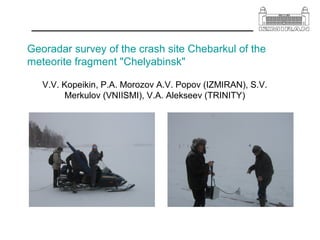
  • 1. Georadar survey of the crash site Chebarkul of the meteorite fragment "Chelyabinsk" V.V. Kopeikin, P.A. Morozov A.V. Popov (IZMIRAN), S.V. Merkulov (VNIISMI), V.A. Alekseev (TRINITY)
  • 2. Attempts to find a meteorite in the bottom of the lake in the vicinity of open water were unsuccessful, although scientists and local residents removed from the hole using a magnet small fragments with significant iron content. The depth of the lake in the vicinity of a meteorite about 10 meters, divers made it difficult to work the thick layer of loose silt, reaching at their estimated depth two or more meters. According to witnesses one of the largest meteorite fragments "Chelyabinsk" February 15, 2013 fell in the western part of the lake Chebarkul, leaving in the ice oval wormwood sized 6x8 m.
  • 3. To clarify the probable location of the Chebarcul fragment, was carried out a remote sensing of the lake bottom with GPR "Loza-H", developed at the Institute of Terrestrial Magnetism, Ionosphere and Radio Wave Propagation. NV Pushkov (IZMIRAN) Ltd. and produced by VNIISMI The principle of operation is based on the GPR radiation of ultra-wideband electromagnetic pulses in the underlying environment and recording their reflections from the interfaces between the layers or objects A distinctive feature of the instrument series "LOZA", compared with foreign and domestic counterparts, is a great energy potential, allowing to work in environments with high conductivity, such as clay loam or wet The probe pulse is generated by high-voltage gas discharge tube (5-10 kV) and radiated resistor loaded dipole antenna length of 0.5 to 6 meters. A similar antenna is used in the receiver «LOZA-V», «LOZA-N», Depending on the model of the device and environment settings probing depth ranges from a few to hundreds of meters
  • 4. During the three days of field work (12-14 March 2013) the expedition IZMIRAN- VNIISMI produced 36 GPR profiles length of 100-150 m in the area of the meteorite. The grid covers the wormwood and the area of 100x100 m to the west of it. Sounding produced from the surface of the ice allowed restore a detailed picture of the bottom topography and indicate the most likely place of occurrence of a meteorite or its fragments Furthermore, in the area of incidence, water samples and the fine fraction of the ice fragments were collected for further analysis of the physico- chemical
  • 5. Below is a sample representation of the raw data of GPR sensing program "Krot1301" developed VNIISMI. The right panel is a waveform pulses detected by the receiver in the selected GPR profile point (A-scan). With the passage of the track are formed in vertical sections (B-scan), shown in the two left panels. Horizontal postponed distance in meters vertically - the time of arrival of the reflected pulse in nanoseconds (right scale) and the estimated depth of the reflecting boundary (left scale) Р602 Р603 Bands in the top of the picture correspond to the direct signal propagating from the transmitting to the receiving antenna at different speeds - in the air, in the thick snow and in the water beneath the ice. Underlying the broad bands correspond lengthy unipolar pulses reflected from a smooth transition from the sludge to the bottom of the solid rocks. Bands in the top of the picture correspond to the direct signal propagating from the transmitting to the receiving antenna at different speeds - in the air, in the thick snow and in the water beneath the ice. Underlying the broad bands correspond lengthy unipolar pulses reflected from a smooth transition from the sludge to the bottom of the solid rocks. Noteworthy is a violation of the structure of the ice cover and a sharp drop in the bottom topography on the profile P602 at the intersection with the profile of R603. We interpret this anomaly as the result of a meteorite impact on the bottom of the lake. Noteworthy is a violation of the structure of the ice cover and a sharp drop in the bottom topography on the profile P602 at the intersection with the profile of R603.
  • 6. Further confirmation of this hypothesis are the observational facts. Apparently, it is generally accepted that the Chebarkul meteorite fragments approached the lake in the north-east direction with an azimuth of 280-290 degrees inclined path. Therefore, look for it at the bottom of tracks necessary to the west of the polynya (open areas in frozen seas). A small amount of the ejected ice around polynyas suggests that the bulk of its mass was infatuated with a meteorite, and then surfaced, breaking the structure of the ice cover over the funnel. Based on this fact, we conducted a detailed areal sensing portion bottom situated between the shore and wormwood. Linear profiles processed by the program "Krot" and 3D reconstruction of the bottom topography reveal a dramatic deepening in this sector is likely caused by the fall of a meteorite fragment. Further confidence can give a comparison with the magnetic measurements
  • 7. 3D model of the surface of the bottom of the river, with traces of the fall and the crater.