SlideShare une entreprise Scribd logo
1  sur  86
THE SURF ZONE
A photo tour of selected beaches to
               illustrate:
  • Plunging and spilling breakers
        • Longshore currents
            • Rip currents
              • Undertow
    Shoreline Community College
         Oceanography 101
           Linda Khandro
HOW TO PROCEED

• First of all, study ALL the pictures and videos of the surf and beach
  slope formations in this Power Point. Take your time and enjoy!
• STOP when you get to (about) slide 76 with the instructions. This
  slide and the ones following it, are also attached to the EX6
  Assignment page in our Blackboard Week 6 folder. Download and
  save the file from Blackboard to your hard drive, labeling as usual:
  lastname_ex6.doc.
• Print that file for easy reference as you go through these pictures
  and videos again.
• Answer all the questions on your new file.
• When you come to question D, about “rip tides”, rip currents, and
  longshore currents, BE SURE to go back to slide 74. There you must
  open the links to see and hear about the formation of rip currents
  from longshore currents.
• Finish answering the questions on your file and attach to the
  Blackboard Assignment page.

• You’re done! Now watch out for rip currents and undertow!
Some
beaches of
Ireland…
Some
beaches of
New
Zealand…
Some beaches of Baja, Mexico:
The west side is on the Pacific
Ocean, the south point of Baja is
between the Pacific and the Sea
of Cortez, and the east side is on
the Sea of Cortez.
Some of these slides are videos. Mouse
over the slide until the white box shows
up at the bottom. Click on the arrow at
the bottom left side.
Beach at El Pozo
Hondo, near
Todos Santos
(west side)…
Los Cerritos
beach, near
Todos Santos
(west side)…
Beach at Playa
Grande, near
Cabo San Lucas,
south point of
Baja
Beach at San
Jose del Cabo,
south point of
Baja…
Beach at Cabo
Pulmo, east side
of Baja (Sea of
Cortez)…
Some beaches of Yucatan,
Mexico: Puerto Morelos and
Cancun are both on the Caribbean
side of the Yucatan Peninsula.

Some of these slides are videos. Mouse
over the slide until the white box shows up
at the bottom. Click on the arrow at the
bottom left side.
Puerto Morelos
beach, with the
Mesoamerican
Reef offshore
(white surf)…
Cancun
beach…
Some beaches
of Cape Cod,
Massachusetts
…
.
THE SURF ZONE
             Some important points:
1. There are 3 main types of surf, with surging, plunging
and spilling breakers, all of which form in response to
various factors of the beach slope, including the
steepness of the slope. We are discussing only plunging
and spilling waves, or breakers, here.
2. A steeply sloping beach face can create a strong
undertow.
3. Converging longshore currents can create rip currents.
4. The dangers created by rip currents and undertow are
real, but are not the same.
Fig. 11-12, p. 253
Fig. 11-14a, p. 255
Fig. 11-14b, p. 255
http://oregonstate.edu/dept/ncs/newsarc
h/2007/Jul07/ripcurrents.html

“If you’re looking out toward the water
and you see the long-shore current coming
from both the left and right, there’s
probably a rip current in front of you.”

http://www.nytimes.com/interactive/200
9/01/06/science/20090106-
sandslide/index.html
INSRUCTIONS FOR THE EXERCISE:

Now download and print the Blackboard EX6
Assignment page! If you already have it, you’re ready to
go back to the beaches slides above, then answer the
questions on the Assignment page.

Use your Textbook pages 210-211 and the Glossary
pages 420 & 423 for further reference to plunging and
spilling breakers.

The following 7 slides just re-state the questions. Type
your answers onto the page you have labeled
lastname_ex6.doc.
A.   Plunging Breakers
1. Which of the beaches illustrate, for the
most part, “plunging” breakers? Name the
beaches as they are labeled on the slides.

2. Which of the beaches with plunging
breakers clearly show(s) a steep beach face?

3. What is the significance (or relationship)
of this kind of beach slope with respect to
the plunging breakers?
B.   Spilling Breakers
1. Which of the beaches illustrate, for the
most part, “spilling” breakers? Name the
beaches as they are labeled on the slides.

2. What is the general slope of these
beaches?

3. What is the significance (or relationship)
of this kind of beach slope with respect to
the spilling breakers?
Reef Breakers: In the Puerto Morelos Reef
pictures, you can see surf breaking on an
offshore reef.
1. What kind of breakers are these,
plunging or spilling? If you can’t tell from
the photos, consider that the reef has a
fairly steep slope on the seaward side.
D. Rip (tides or currents?) At Playa
Grande beach, you will see a red warning
sign (previous slide) advising guests not to
swim due to the Rip Tide there.

1. Define Rip Tide (if you can!).

2. Define Rip Current. What kind of beach
process must be present for a rip current
to form? If in doubt, see Slide 78 again.
3. According to the beach photos
themselves (not the sign), do you see
evidence of a Rip Current at Playa Grande?

4. If there is no Rip Current at Playa
Grande, how else would you warn
potential swimmers here? Look again at
the seaward flow of water after the surf
breaks; look at the slope of the beach face
and think about the fundamental force of
nature which creates that flow of water.
5. What name (or names) do we give
   to that seaward flow of water?


 6. What is the fundamental force of
nature that creates the danger at this
                beach?

Contenu connexe

Similaire à The surf zone

Coastal features of erosion
Coastal features of erosionCoastal features of erosion
Coastal features of erosionLala Gordon
 
Coastal features of erosion
Coastal features of erosionCoastal features of erosion
Coastal features of erosionMsgordon2014
 
Coastlines Yr 11 Revision Class For Ocr Spec A
Coastlines Yr 11 Revision Class For Ocr Spec ACoastlines Yr 11 Revision Class For Ocr Spec A
Coastlines Yr 11 Revision Class For Ocr Spec AKateW
 
Module 1 e lc lesson
Module 1 e lc lessonModule 1 e lc lesson
Module 1 e lc lessonsdemichael
 
Coastal processes this one
Coastal processes this oneCoastal processes this one
Coastal processes this oneDavid Rogers
 
L3.ap longshore drift and deposition
L3.ap longshore drift and depositionL3.ap longshore drift and deposition
L3.ap longshore drift and depositionandypinks
 
G115 Virtual Field Trip #2 Coastal Exploration Page 1 G.docx
G115 Virtual Field Trip #2 Coastal Exploration Page 1 G.docxG115 Virtual Field Trip #2 Coastal Exploration Page 1 G.docx
G115 Virtual Field Trip #2 Coastal Exploration Page 1 G.docxhanneloremccaffery
 
L5 dep features & playdoh
L5 dep features & playdohL5 dep features & playdoh
L5 dep features & playdohandypinks
 
Coastal Controlled Assessment Prep
Coastal Controlled Assessment PrepCoastal Controlled Assessment Prep
Coastal Controlled Assessment PrepMrs Coles
 
Bob Pratt & David Benjamin "Great Lakes Surf Rescue" NDPA Symposium 2012
Bob Pratt & David Benjamin "Great Lakes Surf Rescue" NDPA Symposium 2012Bob Pratt & David Benjamin "Great Lakes Surf Rescue" NDPA Symposium 2012
Bob Pratt & David Benjamin "Great Lakes Surf Rescue" NDPA Symposium 2012National Drowning Prevention Alliance
 
Integrated Science M4 Tsunamis
Integrated Science M4 TsunamisIntegrated Science M4 Tsunamis
Integrated Science M4 TsunamiseLearningJa
 
TCOM GOAL ORIENTED PRESENTATION
TCOM GOAL ORIENTED PRESENTATIONTCOM GOAL ORIENTED PRESENTATION
TCOM GOAL ORIENTED PRESENTATIONAsantHayes
 
Coastal erosion processes
Coastal erosion processesCoastal erosion processes
Coastal erosion processesMrs Coles
 
Carmel lagoonfieldtrip 3.11
Carmel lagoonfieldtrip 3.11Carmel lagoonfieldtrip 3.11
Carmel lagoonfieldtrip 3.11todspedding
 
Imass October 2013 Newsletter
Imass October 2013 NewsletterImass October 2013 Newsletter
Imass October 2013 NewsletterAtlantic Scuba
 
Earth-and-Life-Science-Q1-Week-9.pdf
Earth-and-Life-Science-Q1-Week-9.pdfEarth-and-Life-Science-Q1-Week-9.pdf
Earth-and-Life-Science-Q1-Week-9.pdfEdchelo1
 
02 Coastal Stabilization And Alternative Solutions
02  Coastal Stabilization And Alternative Solutions02  Coastal Stabilization And Alternative Solutions
02 Coastal Stabilization And Alternative SolutionsKrystian Pilarczyk
 

Similaire à The surf zone (20)

Coastal features of erosion
Coastal features of erosionCoastal features of erosion
Coastal features of erosion
 
Coastal features of erosion
Coastal features of erosionCoastal features of erosion
Coastal features of erosion
 
Rip Tides (C. Johnson)
Rip Tides   (C. Johnson)Rip Tides   (C. Johnson)
Rip Tides (C. Johnson)
 
Coastlines Yr 11 Revision Class For Ocr Spec A
Coastlines Yr 11 Revision Class For Ocr Spec ACoastlines Yr 11 Revision Class For Ocr Spec A
Coastlines Yr 11 Revision Class For Ocr Spec A
 
Module 1 e lc lesson
Module 1 e lc lessonModule 1 e lc lesson
Module 1 e lc lesson
 
Riversafety (1)
Riversafety (1)Riversafety (1)
Riversafety (1)
 
Coastal processes this one
Coastal processes this oneCoastal processes this one
Coastal processes this one
 
L3.ap longshore drift and deposition
L3.ap longshore drift and depositionL3.ap longshore drift and deposition
L3.ap longshore drift and deposition
 
G115 Virtual Field Trip #2 Coastal Exploration Page 1 G.docx
G115 Virtual Field Trip #2 Coastal Exploration Page 1 G.docxG115 Virtual Field Trip #2 Coastal Exploration Page 1 G.docx
G115 Virtual Field Trip #2 Coastal Exploration Page 1 G.docx
 
L5 dep features & playdoh
L5 dep features & playdohL5 dep features & playdoh
L5 dep features & playdoh
 
Coastal Controlled Assessment Prep
Coastal Controlled Assessment PrepCoastal Controlled Assessment Prep
Coastal Controlled Assessment Prep
 
Bob Pratt & David Benjamin "Great Lakes Surf Rescue" NDPA Symposium 2012
Bob Pratt & David Benjamin "Great Lakes Surf Rescue" NDPA Symposium 2012Bob Pratt & David Benjamin "Great Lakes Surf Rescue" NDPA Symposium 2012
Bob Pratt & David Benjamin "Great Lakes Surf Rescue" NDPA Symposium 2012
 
Integrated Science M4 Tsunamis
Integrated Science M4 TsunamisIntegrated Science M4 Tsunamis
Integrated Science M4 Tsunamis
 
TCOM GOAL ORIENTED PRESENTATION
TCOM GOAL ORIENTED PRESENTATIONTCOM GOAL ORIENTED PRESENTATION
TCOM GOAL ORIENTED PRESENTATION
 
Coastal erosion processes
Coastal erosion processesCoastal erosion processes
Coastal erosion processes
 
Carmel lagoonfieldtrip 3.11
Carmel lagoonfieldtrip 3.11Carmel lagoonfieldtrip 3.11
Carmel lagoonfieldtrip 3.11
 
SoCiAl sTuDiEs BlOg
SoCiAl sTuDiEs BlOgSoCiAl sTuDiEs BlOg
SoCiAl sTuDiEs BlOg
 
Imass October 2013 Newsletter
Imass October 2013 NewsletterImass October 2013 Newsletter
Imass October 2013 Newsletter
 
Earth-and-Life-Science-Q1-Week-9.pdf
Earth-and-Life-Science-Q1-Week-9.pdfEarth-and-Life-Science-Q1-Week-9.pdf
Earth-and-Life-Science-Q1-Week-9.pdf
 
02 Coastal Stabilization And Alternative Solutions
02  Coastal Stabilization And Alternative Solutions02  Coastal Stabilization And Alternative Solutions
02 Coastal Stabilization And Alternative Solutions
 

The surf zone

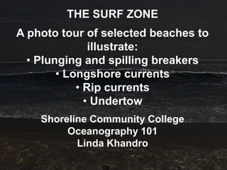
  • 1. THE SURF ZONE A photo tour of selected beaches to illustrate: • Plunging and spilling breakers • Longshore currents • Rip currents • Undertow Shoreline Community College Oceanography 101 Linda Khandro
  • 2. HOW TO PROCEED • First of all, study ALL the pictures and videos of the surf and beach slope formations in this Power Point. Take your time and enjoy! • STOP when you get to (about) slide 76 with the instructions. This slide and the ones following it, are also attached to the EX6 Assignment page in our Blackboard Week 6 folder. Download and save the file from Blackboard to your hard drive, labeling as usual: lastname_ex6.doc. • Print that file for easy reference as you go through these pictures and videos again. • Answer all the questions on your new file. • When you come to question D, about “rip tides”, rip currents, and longshore currents, BE SURE to go back to slide 74. There you must open the links to see and hear about the formation of rip currents from longshore currents. • Finish answering the questions on your file and attach to the Blackboard Assignment page. • You’re done! Now watch out for rip currents and undertow!
  • 4.
  • 5.
  • 6.
  • 7.
  • 8.
  • 9.
  • 11.
  • 12.
  • 13.
  • 14.
  • 15. Some beaches of Baja, Mexico: The west side is on the Pacific Ocean, the south point of Baja is between the Pacific and the Sea of Cortez, and the east side is on the Sea of Cortez. Some of these slides are videos. Mouse over the slide until the white box shows up at the bottom. Click on the arrow at the bottom left side.
  • 16. Beach at El Pozo Hondo, near Todos Santos (west side)…
  • 17.
  • 18.
  • 19.
  • 20. Los Cerritos beach, near Todos Santos (west side)…
  • 21.
  • 22.
  • 23.
  • 24.
  • 25. Beach at Playa Grande, near Cabo San Lucas, south point of Baja
  • 26.
  • 27.
  • 28.
  • 29.
  • 30.
  • 31.
  • 32.
  • 33.
  • 34.
  • 35.
  • 36.
  • 37. Beach at San Jose del Cabo, south point of Baja…
  • 38.
  • 39.
  • 40.
  • 41.
  • 42.
  • 43.
  • 44.
  • 45.
  • 46.
  • 47. Beach at Cabo Pulmo, east side of Baja (Sea of Cortez)…
  • 48.
  • 49.
  • 50.
  • 51.
  • 52.
  • 53.
  • 54.
  • 55. Some beaches of Yucatan, Mexico: Puerto Morelos and Cancun are both on the Caribbean side of the Yucatan Peninsula. Some of these slides are videos. Mouse over the slide until the white box shows up at the bottom. Click on the arrow at the bottom left side.
  • 56. Puerto Morelos beach, with the Mesoamerican Reef offshore (white surf)…
  • 57.
  • 58.
  • 59.
  • 61.
  • 62.
  • 63.
  • 64.
  • 65.
  • 66.
  • 67.
  • 68. Some beaches of Cape Cod, Massachusetts … .
  • 69.
  • 70.
  • 71.
  • 72.
  • 73.
  • 74. THE SURF ZONE Some important points: 1. There are 3 main types of surf, with surging, plunging and spilling breakers, all of which form in response to various factors of the beach slope, including the steepness of the slope. We are discussing only plunging and spilling waves, or breakers, here. 2. A steeply sloping beach face can create a strong undertow. 3. Converging longshore currents can create rip currents. 4. The dangers created by rip currents and undertow are real, but are not the same.
  • 78. http://oregonstate.edu/dept/ncs/newsarc h/2007/Jul07/ripcurrents.html “If you’re looking out toward the water and you see the long-shore current coming from both the left and right, there’s probably a rip current in front of you.” http://www.nytimes.com/interactive/200 9/01/06/science/20090106- sandslide/index.html
  • 79. INSRUCTIONS FOR THE EXERCISE: Now download and print the Blackboard EX6 Assignment page! If you already have it, you’re ready to go back to the beaches slides above, then answer the questions on the Assignment page. Use your Textbook pages 210-211 and the Glossary pages 420 & 423 for further reference to plunging and spilling breakers. The following 7 slides just re-state the questions. Type your answers onto the page you have labeled lastname_ex6.doc.
  • 80. A. Plunging Breakers 1. Which of the beaches illustrate, for the most part, “plunging” breakers? Name the beaches as they are labeled on the slides. 2. Which of the beaches with plunging breakers clearly show(s) a steep beach face? 3. What is the significance (or relationship) of this kind of beach slope with respect to the plunging breakers?
  • 81. B. Spilling Breakers 1. Which of the beaches illustrate, for the most part, “spilling” breakers? Name the beaches as they are labeled on the slides. 2. What is the general slope of these beaches? 3. What is the significance (or relationship) of this kind of beach slope with respect to the spilling breakers?
  • 82. Reef Breakers: In the Puerto Morelos Reef pictures, you can see surf breaking on an offshore reef. 1. What kind of breakers are these, plunging or spilling? If you can’t tell from the photos, consider that the reef has a fairly steep slope on the seaward side.
  • 83.
  • 84. D. Rip (tides or currents?) At Playa Grande beach, you will see a red warning sign (previous slide) advising guests not to swim due to the Rip Tide there. 1. Define Rip Tide (if you can!). 2. Define Rip Current. What kind of beach process must be present for a rip current to form? If in doubt, see Slide 78 again.
  • 85. 3. According to the beach photos themselves (not the sign), do you see evidence of a Rip Current at Playa Grande? 4. If there is no Rip Current at Playa Grande, how else would you warn potential swimmers here? Look again at the seaward flow of water after the surf breaks; look at the slope of the beach face and think about the fundamental force of nature which creates that flow of water.
  • 86. 5. What name (or names) do we give to that seaward flow of water? 6. What is the fundamental force of nature that creates the danger at this beach?