Remote geosteering presentation
•Télécharger en tant que PPT, PDF•
2 j'aime•1,641 vues

Remote Geo-steering Geological Services

Recommandé
Contenu connexe
Tendances
Tendances (20)
Similaire à Remote geosteering presentation
Similaire à Remote geosteering presentation (20)
Dernier
Dernier (20)
Remote geosteering presentation
- 1. Remote Geosteering and Reservoir Navigation
- 2. Objective: To provide consistent, high quality supervision, in a more effective, efficient and safer manner than the conventional approach EnCana Corporation
- 3. Remote Geosteering - WHY - Safety - Costs - Data Flow - Communication - Real Time Decision Making - 24/7 Supervision
- 4. Remote Geosteering - Where • Horizontal wells with no need for real-time sample description. (Steering based on LWD/MWD data and drilling parameters) • Drilling close to the roof of the reservoir • Night supervision for one man Hz jobs • Follow optimum reservoir zones • Drilling a set distance above the water contact • Avoid unproductive zones in the reservoir • Optimal wellpath placement • Combining two or several of these objectives in one well EnCana Corporation
- 5. Remote Geosteering - How Continuous supervision Real time assessment of stratigraphic location Relation to markers Position within porosity windows Critical evaluation of wellpath shape Optimal landing using TVD logs Timeline estimates Critical Formation tops Casing points Entering reservoir Reaching TD Exhaustive daily and final reports Wireline Logging Supervision
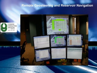
- 6. Remote Geosteering - How Real Time Monitoring - 24 hour supervision
- 7. Petrographer: Detailed Descriptions High Quality Digital Photography
- 8. Petrographer Standardized and comparable sample descriptions Calgary Alberta | April 22nd, 2009 F.N.B.U.
- 9. Field Rover: Gas detection Sample Collection Digital Photography
- 10. Field Digital Pictures - Clastics Trained Rover / Mudlogger EnCana Corporation
- 11. Monitor current rig operations, paying particular attention to nature of bottom hole assembly in the hole (slick, stiff, pendulum, directional, etc.). Although this is a drilling matter, the remote geologist must understand all operations, and recognize any deviations from the drilling program. If any deviations are observed, Client’s personnel are notified as per protocol.
- 12. Horizontal Path (Gamma, DH Pressure) EnCana Corporation
- 13. Directional Drilling Supervision Synergetic communication Collision Avoidance Plot wellpath into Petrel, and proactively evaluate wellpath position in relation to existing and planned wellbores (provides an additional line of defense in the avoidance wellbore collisions) EnCana Corporation
- 14. Additional Benefits Knowledge and resources shared in all compartments. Standardized internal and government reporting. Detailed daily reports, to be distributed within the company and to partners as needed. Everything stored on client’s dedicated data base, using consistent file naming protocol. Further reduction in cost is realized by reducing the required number of accommodations, Pason terminals and trailer transportation costs on the lease. EnCana Corporation
- 15. Petrel Completion - Daily Reporting EnCana Corporation
- 16. SteerRight™ In-House Software EnCana Corporation
- 17. Accurate Detail EnCana Corporation
- 18. Remote Geosteering Chinook Consulting Services www.chinookconsultingservices.ca EnCana Corporation
Notes de l'éditeur
- This plot shows the correlation of the volume of fluid pumped versus the average 30 day max month rate following completion. This relationship of more stages frac’d and larger fluid volumes shows that well performance can be increased by optimizing completions. The 2009 budget was based on 8 stages per well, however with the results of the b-C76-K well this fall, the plan has shifted to 10 stages per well and we are working on the justification to realize up to 14 stages per well. As part of their Q3 results, EOG released information that 3 wells in their Horn River program had IPs of 6 to 19 MMcf/d. One well has been identified to have 14 stages frac’d resulting in a 30 day IP of 10.8 MMcf/d. Relating frac stages to spacing, a 10 stage per well program would equate to 12 acres per interval while a 14 stage per well program would equate to 8 acres. As a comparison, the Barnett in the Fort Worth Basin is being spaced typically to 6 acres with downspacing pilots testing 3 acres.