SlideShare une entreprise Scribd logo
1  sur  20
Latitude
From Wikipedia, the free encyclopedia

Jump to: navigation, search
This article is about the geographical reference system. For other uses,
see Latitude (disambiguation).


A graticule on a sphere or an ellipsoid. The lines from pole to pole are lines of constant
longitude, or meridians. The circles parallel to the equator are lines of constant latitude,
or parallels. The graticule determines the latitude and longitude of position on the
surface.
In geography, latitude (φ) is a geographic coordinate that specifies the
north-south position of a point on the Earth's surface. Lines of constant
latitude, or parallels, run east–west as circles parallel to the equator.
Latitude is an angle (defined below) which ranges from 0° at the Equator to
90° (North or South) at the poles.
Latitude is used together with longitude to specify the precise location of
features on the surface of the Earth. Since the actual physical surface of
the Earth is too complex for mathematical analysis, two levels of
abstraction are employed in the definition of these coordinates. In the first
step the physical surface is modelled by the geoid, a surface which
approximates the mean sea level over the oceans and its continuation
under the land masses. The second step is to approximate the geoid by a
mathematically simpler reference surface. The simplest choice for the
reference surface is a sphere, but the geoid is more accurately modelled
by an ellipsoid. The definitions of latitude and longitude on such reference
surfaces are detailed in the following sections. Lines of constant latitude
and longitude together constitute a graticule on the reference surface. The
latitude of a point on the actual surface is that of the corresponding point
on the reference surface, the correspondence being along the normal to
the reference surface which passes through the point on the physical
surface. Latitude and longitude together with some specification of height
constitute a geographic coordinate system as defined in the specification
of the ISO 19111 standard.[1]
Since there are many different reference ellipsoids the latitude of a feature
on the surface is not unique: this is stressed in the ISO standard which
states that "without the full specification of the coordinate reference
system, coordinates (that is latitude and longitude) are ambiguous at best
and meaningless at worst". This is of great importance in accurate
applications, such as GPS, but in common usage, where high accuracy is
not required, the reference ellipsoid is not usually stated.
In English texts the latitude angle, defined below, is usually denoted by the
Greek lower-case letter phi (φ or ɸ ). It is measured in degrees, minutes
and seconds or decimal degrees, north or south of the equator.
Measurement of latitude requires an understanding of the gravitational field
of the Earth, either for setting up theodolites or for determination of GPS
satellite orbits. The study of the figure of the Earth together with its
gravitational field is the science of Geodesy. These topics are not
discussed in this article. (See for example the textbooks by Torge[2] and
Hofmann-Wellenhof and Moritz.[3])
This article relates to coordinate systems for the Earth: it may be extended
to cover the Moon, planets and other celestial objects by a simple change
of nomenclature.
The following lists are available:
• List of countries by latitude
• List of cities by latitude
              Contents [hide]
             1 Latitude on the sphere
                    1.1 The graticule on
             the sphere
                    1.2 Named latitudes
                    1.3 Map projections
             from the sphere
                    1.4 Meridian distance
             on the sphere
             2 Latitude on the ellipsoid
2.1 Ellipsoids
                         2.2 The geometry of
                 the ellipsoid
                         2.3 Geodetic and
                 geocentric latitudes
                         2.4 The length of a
                 degree of latitude
                 3 Auxiliary latitudes
                         3.1 Geocentric latitude
                         3.2 Reduced (or
                 parametric) latitude
                         3.3 Rectifying latitude
                         3.4 Authalic latitude
                         3.5 Conformal latitude
                         3.6 Isometric latitude
                 4 Numerical comparison of
         auxiliary latitudes
                 5 Latitude and coordinate
         systems
                         5.1 Geodetic
                 coordinates
                         5.2 Spherical polar
                 coordinates
                         5.3 Ellipsoidal
                 coordinates
                         5.4 Coordinate
                 conversions
                 6 Astronomical latitude
                 7 See also
                 8 Footnotes
                 9 External links
[edit]
Latitude on the sphere
A perspective view of the Earth showing how latitude (φ) and longitude (λ) are defined
on a spherical model. The graticule spacing is 10 degrees.
[edit]
The graticule on the sphere
The graticule, the mesh formed by the lines of constant latitude and
constant longitude, is constructed by reference to the rotation axis of the
Earth. The primary reference points are the poles where the axis of
rotation of the Earth intersects the reference surface. Planes which contain
the rotation axis intersect the surface in the meridians and the angle
between any one meridian plane and that through Greenwich (the Prime
Meridian) defines the longitude: meridians are lines of constant longitude.
The plane through the centre of the Earth and orthogonal to the rotation
axis intersects the surface in a great circle called the equator. Planes
parallel to the equatorial plane intersect the surface in circles of constant
latitude; these are the parallels. The equator has a latitude of 0°, the North
pole has a latitude of 90° north (written 90° N or +90°), and the South pole
has a latitude of 90° south (written 90° S or −90°). The latitude of an
arbitrary point is the angle between the equatorial plane and the radius to
that point.
The latitude that is defined in this way for the sphere is often termed the
spherical latitude to avoid ambiguity with auxiliary latitudes defined in
subsequent sections.
[edit]
Named latitudes
The orientation of the Earth at the December solstice.
Besides the equator, four other parallels are of significance:
                       66° 33′ 39″
Arctic Circle
                       N
                       23° 26′ 21″
Tropic of Cancer
                       N
Tropic of              23° 26′ 21″
Capricorn              S
                       66° 33′ 39"
Antarctic Circle
                       S
The plane of the Earth's orbit about the sun is called the ecliptic. The plane
perpendicular to the rotation axis of the Earth is the equatorial plane. The
angle between the ecliptic and the equatorial plane is called the inclination
of the ecliptic, denoted by in the figure. The current value of this angle is
23° 26′ 21″.[4] It is also called the axial tilt of the Earth since it is equal to
the angle between the axis of rotation and the normal to the ecliptic.
The figure shows the geometry of a cross section of the plane normal to
the ecliptic and through the centres of the Earth and the Sun at the
December solstice when the sun is overhead at some point of the Tropic of
Capricorn. The south polar latitudes below the Antarctic Circle are in
daylight whilst the north polar latitudes above the Arctic Circle are in night.
The situation is reversed at the June solstice when the sun is overhead at
the Tropic of Cancer. The latitudes of the tropics are equal to the
inclination of the ecliptic and the polar circles are at latitudes equal to its
complement. Only at latitudes in between the two tropics is it possible for
the sun to be directly overhead (at the zenith).
The named parallels are clearly indicated on the Mercator projections
shown below.
[edit]
Map projections from the sphere
On map projections there is no simple rule as to how meridians and
parallels should appear. For example, on the spherical Mercator projection
the parallels are horizontal and the meridians are vertical whereas on the
Transverse Mercator projection there is no correlation of parallels and
meridians with horizontal and vertical, both are complicated curves. The
red lines are the named latitudes of the previous section.
                Normal Mercator                                     Transverse Mercator


For map projections of large regions, or the whole world, a spherical Earth
model is completely satisfactory since the variations attributable to
ellipticity are negligible on the final printed maps.
[edit]
Meridian distance on the sphere
On the sphere the normal passes through the centre and the latitude (φ) is
therefore equal to the angle subtended at the centre by the meridian arc
from the equator to the point concerned. If the meridian distance is
denoted by m(φ) then


where R denotes the mean radius of the Earth. R is equal to 6371 km or
3959 miles. No higher accuracy is appropriate for R since higher precision
results necessitate an ellipsoid model. With this value for R the meridian
length of 1 degree of latitude on the sphere is 111.2 km or 69 miles. The
length of 1 minute of latitude is 1.853 km, or 1.15 miles. (See nautical
mile).
[edit]
Latitude on the ellipsoid
[edit]
Ellipsoids
In 1687 Isaac Newton published the Principia in which he included a proof
that a rotating self-gravitating fluid body in equilibrium takes the form of an
oblate ellipsoid.[5] (This article uses the term ellipsoid in preference to the
older term spheroid). Newton's theoretical result was confirmed by precise
geodetic measurements in the eighteenth century. (See Meridian arc). The
definition of an oblate ellipsoid is the three dimensional surface generated
by the rotation of a two dimensional ellipse about its shorter axis (minor
axis). 'Oblate ellipsoid of revolution' is abbreviated to ellipsoid in the
remainder of this article: this is the current practice in geodetic literature.
(Ellipsoids which do not have an axis of symmetry are termed tri-axial).
A great many different reference ellipsoids have been used in the history of
geodesy. In pre-satellite days they were devised to give a good fit to the
geoid over the limited area of a survey but, with the advent of GPS, it has
become natural to use reference ellipsoids (such as WGS84) with centres
at the centre of mass of the Earth and minor axis aligned to the rotation
axis of the Earth. These geocentric ellipsoids are usually within 100m of
the geoid. Since latitude is defined with respect to an ellipsoid the position
of a given feature is different on each ellipsoid: it is meaningless to specify
the latitude and longitude of a geographical feature without specifying the
ellipsoid used. The maps maintained by many national agencies are often
based on the older ellipsoids so that is necessary to know how the latitude
and longitude values may be transformed from one ellipsoid to another.
For example GPS handsets must include software to carry out datum
transformations which link WGS84 to the local reference ellipsoid with its
associated grid reference system.
[edit]
The geometry of the ellipsoid
The overall shape of an ellipsoid of revolution is determined by the shape
of the ellipse which is rotated about its minor (shorter) axis. Two
parameters are required. One is invariably chosen to be the equatorial
radius, which is the semi-major axis, a. The other parameter is usually
taken as one of three possibilities: (1) the polar radius or semi-minor axis,
b; (2) the (first) flattening, f; (3) the eccentricty, e. These parameters are
not independent: they are related by


A great many other parameters (see ellipse, ellipsoid) are used in the
study of the ellipsoid in geodesy, geophysics and map projections but they
can all may be expressed in terms of one or two members of the set a, b, f
and e. Both f and e are small parameters which often appear in series
expansions involved in practical calculations; they are of the order 1/300
and 0.08 respectively. Accurate values for a number of important ellipsoids
are given in Figure of the Earth. It is conventional to define reference
ellipsoids by giving the semi-major axis and the inverse flattening, 1/f. For
example, the defining values for the WGS84 ellipsoid, used by all GPS
devices, are[6]
• a (equatorial radius): 6,378,137.0 m
• 1/f (inverse flattening): 298.257,223,563
from which are derived
• b (polar radius): 6,356,752.3142 m
• e2 (eccentricity squared): 0.006,694,379,990,14
The difference of the major and minor semi-axes is approximately 21 km
and as fraction of the semi-major axis it is given by the flattening. Thus the
representation of the ellipsoid on a computer could be sized as 300px by
299px. Since this would be indistinguishable from a sphere shown as
300px by 300px illustrations invariably greatly exaggerate the flattening.
[edit]
Geodetic and geocentric latitudes


The definition of geodetic latitude (φ) and longitude (λ) on an ellipsoid. The normal to the
surface does not pass through the centre.
The graticule on the ellipsoid is constructed in exactly the same way as on
the sphere. The normal at a point on the surface of an ellipsoid does not
pass through the centre, except for points on the equator or at the poles,
but the definition of latitude remains unchanged as the angle between the
normal and the equatorial plane. The terminology for latitude must be
made more precise by distinguishing
Geodetic latitude: the angle between the normal and the equatorial plane.
The standard notation in English publications is φ. This is the definition
assumed when the word latitude is used without qualification. The
definition must be accompanied with a specification of the ellipsoid.
Geocentric latitude: the angle between the radius (from centre to the
point on the surface) and the equatorial plane. (Figure below). There is no
standard notation: examples from various texts include ψ, q, φ', φc, φg. This
article uses ψ.
Spherical latitude: the angle between the normal to a spherical reference
surface and the equatorial plane.
Geographic latitude must be used with care. Some authors use it as a
synonym for geodetic latitude whilst others use it as an alternative to the
astronomical latitude.
Latitude (unqualified) should normally refer to the geodetic latitude.
The importance of specifying the reference datum may be illustrated by a
simple example. On the reference ellipsoid for WGS84, the centre of the
Eiffel Tower has a geodetic latitude of 48° 51′ 29″ N, or 48.8583° N and
longitude of 2° 17′ 40″ E or 2.2944°E. The same coordinates on the datum
ED50 define a point on the ground which is 140 m distant from
Tower.[citation needed] A web search may produce several different values
for the latitude of the Tower; the reference ellipsoid is rarely specified.
[edit]
The length of a degree of latitude
In Meridian arc and standard texts[2][7][8] it is shown that the distance along
a meridian from latitude φ to the equator is given by (φ in radians)


The function           in the first integral is the meridional radius of
curvature.
The distance from the equator to the pole is


For WGS84 this distance is 10001.965729 km.
The evaluation of the meridian distance integral is central to many studies
in geodesy and map projection. It can be evaluated by expanding the
integral by the binomial series and integrating term by term: see Meridian
arc for details. The length of the meridian arc between two given latitudes
is given by replacing the limits of the integral by the latitudes concerned.
The length of a small meridian arc is roughly given by[7][8]


0 110.574 k 111.320 k
 °          m           m
1
   110.649 k 107.551 k
5
            m           m
 °
3
   110.852 k 96.486 k
0
            m           m
 °
4
   111.132 k 78.847 k
5
            m           m
 °
6
   111.412 k 55.800 k
0
            m           m
 °
7
   111.618 k 28.902 k
5
            m           m
 °
9
   111.694 k
0               0.000 km
            m
 °
When the latitude difference is 1 degree, corresponding to    /180 radians,
the arc distance is about


The distance in metres (correct to 0.01 metre) between latitudes (
           deg) and (            deg) on the WGS84 spheroid is


The variation of this distance with latitude (on WGS84) is shown in the
table along with the length of a degree of longitude:
A calculator for any latitude is provided by the U.S. government's National
Geospatial-Intelligence Agency(NGA).[9]
[edit]
Auxiliary latitudes
There are six auxiliary latitudes that have applications to special
problems in geodesy, geophysics and the theory of map projections:
• geocentric latitude,
• reduced (or parametric) latitude,
• rectifying latitude,
• authalic latitude,
• conformal latitude,
• isometric latitude.
The definitions given in this section all relate to locations on the reference
ellipsoid but the first two auxiliary latitudes, like the geodetic latitude, can
be extended to define a three dimensional geographic coordinate system
as discussed below. The remaining latitudes are not used in this way; they
are used only as intermediate constructs in map projections of the
reference ellipsoid to the plane: their numerical values are not of interest.
For example no one would need to calculate the authalic latitude of the
Eiffel Tower.
The expressions below give the auxiliary latitudes in terms of the geodetic
latitude, the semi-major axis, a, and the eccentricity, e. The forms given
are, apart from notational variants, those in the standard reference for map
projections, namely "Map projections — a working manual" by
J.P.Snyder.[10] Derivations of these expressions may be found in
Adams[11] and web publications by Rapp[7] and Osborne[8]
[edit]
Geocentric latitude
The definition of geodetic (or geographic) and geocentric latitudes.
The geocentric latitude is the angle between the equatorial plane and the
radius from the centre to a point on the surface. The relation between the
geocentric latitude (ψ) and the geodetic latitude (φ) is derived in the above
references as


The geodetic and geocentric latitudes are equal at the equator and poles.
The value of the squared eccentricity is approximately 0.007 (depending
on the choice of ellipsoid) and the maximum difference of (φ-ψ) is
approximately 11.5 minutes of arc at a geodetic latitude of 45°5′.
[edit]
Reduced (or parametric) latitude


Definition of the reduced latitude (β) on the ellipsoid.
The reduced or parametric latitude, β, is defined by the radius drawn
from the centre of the ellipsoid to that point Q on the surrounding sphere
(of radius a) which is the projection parallel to the Earth's axis of a point P
on the ellipsoid at latitude . It was introduced by Legendre[12] and
Bessel[13] who solved problems for geodesics on the ellipsoid by
transforming them to an equivalent problem for spherical geodesics by
using this smaller latitude. Bessel's notation,        , is also used in the
current literature. The reduced latitude is related to the geodetic latitude
by[7][8]


The alternative name arises from the parameterization of the equation of
the ellipse describing a meridian section. In terms of Cartesian coordinates
p, the distance from the minor axis, and z, the distance above the
equatorial plane, the equation of the ellipse is


The Cartesian coordinates of the point are parameterized by

Cayley[14] suggested the term parametric latitude because of the form of
these equations.
The reduced latitude is not used in the theory of map projections. Its most
important application is in the theory of ellipsoid geodesics. (Vincenty,
Karney[15]).
[edit]
Rectifying latitude
The rectifying latitude, μ, is the meridian distance scaled so that its value
at the poles is equal to 90 degrees or π/2 radians:


where the meridian distance from the equator to a latitude φ is (see
Meridian arc)


and the length of the meridian quadrant from the equator to the pole is


Using the rectifying latitude to define a latitude on a sphere of radius
defines a projection from the ellipsoid to the sphere such that all meridians
have true length and uniform scale. The sphere may then be projected to
the plane with an equirectangular projection to give a double projection
from the ellipsoid to the plane such that all meridians have true length and
uniform meridian scale. An example of the use of the rectifying latitude is
the Equidistant conic projection. (Snyder,[10] Section 16). The rectifying
latitude is also of great importance in the construction of the Transverse
Mercator projection.
[edit]
Authalic latitude
The authalic (Greek for same area) latitude, ξ, gives an area-preserving
transformation to a sphere.


where


and


and the radius of the sphere is taken as


An example of the use of the authalic latitude is the Albers equal-area
conic projection. (Snyder,[10] Section 14).
[edit]
Conformal latitude
The conformal latitude, χ, gives an angle-preserving (conformal)
transformation to the sphere.
.
The conformal latitude defines a transformation from the ellipsoid to a
sphere of arbitrary radius such that the angle of intersection between any
two lines on the ellipsoid is the same as the corresponding angle on the
sphere (so that the shape of small elements is well preserved). A further
conformal transformation from the sphere to the plane gives a conformal
double projection from the ellipsoid to the plane. This is not the only way of
generating such a conformal projection. For example, the 'exact' version of
the Transverse Mercator projection on the ellipsoid is not a double
projection. (It does, however, involve a generalisation of the conformal
latitude to the complex plane).
[edit]
Isometric latitude
The isometric latitude is conventionally denoted by ψ (not to be confused
with the geocentric latitude): it is used in the development of the ellipsoidal
versions of the normal Mercator projection and the Transverse Mercator
projection. The name "isometric" arises from the fact that at any point on
the ellipsoid equal increments of ψ and longitude λ give rise to equal
distance displacements along the meridians and parallels respectively. The
graticule defined by the lines of constant ψ and constant λ, divides the
surface of the ellipsoid into a mesh of squares (of varying size). The
isometric latitude is zero at the equator but rapidly diverges from the
geodetic latitude, tending to infinity at the poles. The conventional notation
is given in Snyder[10] (page 15):


For the normal Mercator projection (on the ellipsoid) this function defines
the spacing of the parallels: if the length of the equator on the projection is
E (units of length or pixels) then the distance, y, of a parallel of latitude φ
from the equator is


[edit]
Numerical comparison of auxiliary latitudes
The following plot shows the magnitude of the difference between the
geodetic latitude, (denoted as the 'common' latitude on the plot), and the
auxiliary latitudes other than the isometric latitude (which diverges to
infinity at the poles). In every case the geodetic latitude is the greater. The
differences shown on the plot are in arc minutes. The horizontal resolution
of the plot fails to make clear that the maxima of the curves are not at 45°
but calculation shows that they are within a few arc minutes of 45°. Some
representative data points are given in the table following the plot. Note the
closeness of the conformal and geocentric latitudes. This was exploited in
the days of hand calculators to expedite the construction of map
projections. (Snyder,[10] page 108).


  Approximate difference from geodetic latitude ( )
   Reduc Autha Rectifyi Conform Geocentric
     ed      lic      ng        al
0
   0.00′    0.00′    0.00′      0.00′       0.00′
°
1
5 2.91′     3.89′    4.37′      5.82′       5.82′
°
3
0 5.05′     6.73′    7.57′      10.09′      10.09′
°
4
5 5.84′     7.78′    8.76′      11.67′      11.67′
°
6
0 5.06′     6.75′    7.59′      10.12′      10.13′
°
7
5 2.92′     3.90′    4.39′      5.85′       5.85′
°
9
0 0.00′     0.00′    0.00′      0.00′       0.00′
°
[edit]
Latitude and coordinate systems
The geodetic latitude, or any of the auxiliary latitudes defined on the
reference ellipsoid, constitutes with longitude a two-dimensional coordinate
system on that ellipsoid. To define the position of an arbitrary point it is
necessary to extend such a coordinate system into three dimensions.
Three latitudes are used in this way: the geodetic, geocentric and reduced
latitudes are used in geodetic coordinates, spherical polar coordinates and
ellipsoidal coordinates respectively.
[edit]
Geodetic coordinates
Geodetic coordinates P(ɸ ,λ,h)
At an arbitrary point P consider the line PN which is normal to the
reference ellipsoid. The geodetic coordinates P(ɸ ,λ,h) are the latitude and
longitude of the point N on the ellipsoid and the distance PN. This height
differs from the height above the geoid or a reference height such as that
above mean sea level at a specified location. The direction of PN will also
differ from the direction of a vertical plumb line. The relation of these
different heights requires knowledge of the shape of the geoid and also the
gravity field of the Earth.
[edit]
Spherical polar coordinates


Geocentric coordinate related to spherical polar coordinates P(r, θ, λ)
The geocentric latitude ψ is the complement of the polar angle θ in
conventional spherical polar coordinates in which the coordinates of a
point are P(r, θ, λ) where r is the distance of P from the centre O, θ is the
angle between the radius vector and the polar axis andλ is longitude. Since
the normal at a general point on the ellipsoid does not pass through the
centre it is clear that points on the normal, which all have the same
geodetic latitude, will have differing geocentic latitudes. Spherical polar
coordinate systems are used in the analysis of the gravity field.
[edit]
Ellipsoidal coordinates


Ellipsoidal coordinates P(u,β,λ)
The reduced latitude can also be extended to a three dimensional
coordinate system. For a point P not on the reference ellipsoid (semi-axes
OA and OB) construct an auxiliary ellipsoid which is confocal (same foci F,
F') with the reference ellipsoid: the necessary condition is that the product
ae of semi-major axis and eccentricity is the same for both ellipsoids. Let u
be the semi-minor axis (OD) of the auxiliary ellipsoid. Further let β be the
reduced latitude of P on the auxiliary ellipsoid. The set (u,β,λ) define the
ellipsoid coordinates. (Torge[2] Section 4.2.2). These coordinates are the
natural choice in models of the gravity field for a uniform distribution of
mass bounded by the reference ellipsoid.
[edit]
Coordinate conversions
The relations between the above coordinate systems, and also Cartesian
coordinates are not presented here. The transformation between geodetic
and Cartesian coordinates may be found in Geodetic system. The relation
of Cartesian and spherical polars is given in Spherical coordinate system.
The relation of Cartesian and ellipsoidal coordinates is discussed in
Torge.[2]
[edit]
Astronomical latitude
The astronomical latitude (Φ) is defined as the angle between the
equatorial plane and the true vertical at a point on the surface: the true
vertical, the direction of a plumb line, is the direction of the gravity field at
that point. (The gravity field is the resultant of the gravitational acceleration
and the centrifugal acceleration at that point. See Torge.[2]) The
astronomic latitude is readily accessible by measuring the angle between
the zenith and the celestial pole or alternatively the angle between the
zenith and the sun when the elevation of the latter is obtained from the
almanac.
In general the direction of the true vertical at a point on the surface does
not coincide with the either the normal to the reference ellipsoid or the
normal to the geoid. The deflections between the astronomic and geodetic
normals are only of the order of a few seconds of arc but they are
nevertheless important in high precision geodesy.[2][3]
Astronomical latitude is not to be confused with declination, the coordinate
astronomers used in a simlilar way to describe the locations of stars
north/south of the celestial equator (see equatorial coordinates), nor with
ecliptic latitude, the coordinate that astronomers use to describe the
locations of stars north/south of the ecliptic (see ecliptic coordinates).

Contenu connexe

Tendances

Application of Basic Remote Sensing in Geology
Application of Basic Remote Sensing in GeologyApplication of Basic Remote Sensing in Geology
Application of Basic Remote Sensing in GeologyUzair Khan
 
Landslide Susceptibility Map using Remote Sensing and GIS
Landslide Susceptibility Map using Remote Sensing and GISLandslide Susceptibility Map using Remote Sensing and GIS
Landslide Susceptibility Map using Remote Sensing and GISAtif248367
 
SAR Interferometry Technique
SAR Interferometry TechniqueSAR Interferometry Technique
SAR Interferometry TechniqueNopphawanTamkuan
 
Geodesy, Map Projections - Introduction
Geodesy, Map Projections - IntroductionGeodesy, Map Projections - Introduction
Geodesy, Map Projections - IntroductionDean Mikkelsen
 
Aerial photography.pptx
Aerial photography.pptxAerial photography.pptx
Aerial photography.pptxPramoda Raj
 
Lecture on photogrammetry
Lecture on photogrammetryLecture on photogrammetry
Lecture on photogrammetryWaleed Liaqat
 
Geological mapping
Geological mappingGeological mapping
Geological mappingmadan lal
 
Coordinate systems, datum & map projections
Coordinate systems, datum & map projectionsCoordinate systems, datum & map projections
Coordinate systems, datum & map projectionsKU Leuven
 
Projections and coordinate system
Projections and coordinate systemProjections and coordinate system
Projections and coordinate systemMohsin Siddique
 
Lec_6_Intro to geo-referencing
Lec_6_Intro to geo-referencingLec_6_Intro to geo-referencing
Lec_6_Intro to geo-referencingAtiqa khan
 
.remote sensing.Ece 402 unit-2
.remote sensing.Ece 402 unit-2.remote sensing.Ece 402 unit-2
.remote sensing.Ece 402 unit-2Vandana Verma
 
Topographic Map
Topographic MapTopographic Map
Topographic Mapmjcnavarro
 
Gravity, Expl.ravity
 Gravity, Expl.ravity Gravity, Expl.ravity
Gravity, Expl.ravityahmadraza05
 
Basics of seismic interpretation
Basics of seismic interpretationBasics of seismic interpretation
Basics of seismic interpretationAmir I. Abdelaziz
 
Geophysical survey
Geophysical surveyGeophysical survey
Geophysical surveyAbdul Jabbar
 
ÖNCEL AKADEMİ: INTRODUCTION TO GEOPHYSICS
ÖNCEL AKADEMİ: INTRODUCTION TO GEOPHYSICSÖNCEL AKADEMİ: INTRODUCTION TO GEOPHYSICS
ÖNCEL AKADEMİ: INTRODUCTION TO GEOPHYSICSAli Osman Öncel
 

Tendances (20)

Geological mapping
Geological mappingGeological mapping
Geological mapping
 
Application of Basic Remote Sensing in Geology
Application of Basic Remote Sensing in GeologyApplication of Basic Remote Sensing in Geology
Application of Basic Remote Sensing in Geology
 
SPOT
SPOTSPOT
SPOT
 
Landslide Susceptibility Map using Remote Sensing and GIS
Landslide Susceptibility Map using Remote Sensing and GISLandslide Susceptibility Map using Remote Sensing and GIS
Landslide Susceptibility Map using Remote Sensing and GIS
 
SAR Interferometry Technique
SAR Interferometry TechniqueSAR Interferometry Technique
SAR Interferometry Technique
 
Geodesy, Map Projections - Introduction
Geodesy, Map Projections - IntroductionGeodesy, Map Projections - Introduction
Geodesy, Map Projections - Introduction
 
Aerial photography.pptx
Aerial photography.pptxAerial photography.pptx
Aerial photography.pptx
 
Lecture on photogrammetry
Lecture on photogrammetryLecture on photogrammetry
Lecture on photogrammetry
 
Geological mapping
Geological mappingGeological mapping
Geological mapping
 
Coordinate systems, datum & map projections
Coordinate systems, datum & map projectionsCoordinate systems, datum & map projections
Coordinate systems, datum & map projections
 
Projections and coordinate system
Projections and coordinate systemProjections and coordinate system
Projections and coordinate system
 
Groundwater exploration
Groundwater explorationGroundwater exploration
Groundwater exploration
 
Lec_6_Intro to geo-referencing
Lec_6_Intro to geo-referencingLec_6_Intro to geo-referencing
Lec_6_Intro to geo-referencing
 
introduction-of-GNSS-1
introduction-of-GNSS-1introduction-of-GNSS-1
introduction-of-GNSS-1
 
.remote sensing.Ece 402 unit-2
.remote sensing.Ece 402 unit-2.remote sensing.Ece 402 unit-2
.remote sensing.Ece 402 unit-2
 
Topographic Map
Topographic MapTopographic Map
Topographic Map
 
Gravity, Expl.ravity
 Gravity, Expl.ravity Gravity, Expl.ravity
Gravity, Expl.ravity
 
Basics of seismic interpretation
Basics of seismic interpretationBasics of seismic interpretation
Basics of seismic interpretation
 
Geophysical survey
Geophysical surveyGeophysical survey
Geophysical survey
 
ÖNCEL AKADEMİ: INTRODUCTION TO GEOPHYSICS
ÖNCEL AKADEMİ: INTRODUCTION TO GEOPHYSICSÖNCEL AKADEMİ: INTRODUCTION TO GEOPHYSICS
ÖNCEL AKADEMİ: INTRODUCTION TO GEOPHYSICS
 

Similaire à Latitude

Coordinate system used in Satellite Navigation.pptx
Coordinate system used in Satellite Navigation.pptxCoordinate system used in Satellite Navigation.pptx
Coordinate system used in Satellite Navigation.pptxQuotesBox
 
coordinate systems map Projections and Atoms ppt - - Copy.pptx
coordinate systems map Projections  and Atoms ppt -  - Copy.pptxcoordinate systems map Projections  and Atoms ppt -  - Copy.pptx
coordinate systems map Projections and Atoms ppt - - Copy.pptxBakhtAli10
 
Cartography Unit_ 3.pptx
Cartography Unit_ 3.pptxCartography Unit_ 3.pptx
Cartography Unit_ 3.pptxwarkisafile1
 
2_Earth_and_its_coordinates.ppt
2_Earth_and_its_coordinates.ppt2_Earth_and_its_coordinates.ppt
2_Earth_and_its_coordinates.pptAmitSharma3227
 
Coordinate systems
Coordinate systemsCoordinate systems
Coordinate systemsSaad Raja
 
Basic Geodesy.pdf
Basic Geodesy.pdfBasic Geodesy.pdf
Basic Geodesy.pdfRamMishra65
 
CARTOGRAPHY – yesterday, today and tomorrow
CARTOGRAPHY – yesterday, today and tomorrowCARTOGRAPHY – yesterday, today and tomorrow
CARTOGRAPHY – yesterday, today and tomorrowProf Ashis Sarkar
 
GIS_lec 2_Different_Spatial coordinate system.ppt
GIS_lec 2_Different_Spatial coordinate system.pptGIS_lec 2_Different_Spatial coordinate system.ppt
GIS_lec 2_Different_Spatial coordinate system.pptMahinMobarrat
 
Coordinate System.pdf
Coordinate System.pdfCoordinate System.pdf
Coordinate System.pdfLareebMoeen1
 
Earth Coordinate Systems
Earth Coordinate Systems Earth Coordinate Systems
Earth Coordinate Systems Sheikh Maryam
 
Maps as Models of Earth
Maps as Models of EarthMaps as Models of Earth
Maps as Models of Earthmlong24
 
Maps as Models of Earth
Maps as Models of EarthMaps as Models of Earth
Maps as Models of Earthmlong24
 
Aerial NAVIGATION and FLIGHT PLANNING.pptx
Aerial NAVIGATION and FLIGHT PLANNING.pptxAerial NAVIGATION and FLIGHT PLANNING.pptx
Aerial NAVIGATION and FLIGHT PLANNING.pptxEhtasham Amir
 

Similaire à Latitude (20)

projection
projectionprojection
projection
 
Coordinate system used in Satellite Navigation.pptx
Coordinate system used in Satellite Navigation.pptxCoordinate system used in Satellite Navigation.pptx
Coordinate system used in Satellite Navigation.pptx
 
coordinate systems map Projections and Atoms ppt - - Copy.pptx
coordinate systems map Projections  and Atoms ppt -  - Copy.pptxcoordinate systems map Projections  and Atoms ppt -  - Copy.pptx
coordinate systems map Projections and Atoms ppt - - Copy.pptx
 
Cartography Unit_ 3.pptx
Cartography Unit_ 3.pptxCartography Unit_ 3.pptx
Cartography Unit_ 3.pptx
 
2_Earth_and_its_coordinates.ppt
2_Earth_and_its_coordinates.ppt2_Earth_and_its_coordinates.ppt
2_Earth_and_its_coordinates.ppt
 
Coordinate systems
Coordinate systemsCoordinate systems
Coordinate systems
 
Basic Geodesy.pdf
Basic Geodesy.pdfBasic Geodesy.pdf
Basic Geodesy.pdf
 
datum
datumdatum
datum
 
CARTOGRAPHY – yesterday, today and tomorrow
CARTOGRAPHY – yesterday, today and tomorrowCARTOGRAPHY – yesterday, today and tomorrow
CARTOGRAPHY – yesterday, today and tomorrow
 
GIS_lec 2_Different_Spatial coordinate system.ppt
GIS_lec 2_Different_Spatial coordinate system.pptGIS_lec 2_Different_Spatial coordinate system.ppt
GIS_lec 2_Different_Spatial coordinate system.ppt
 
Coordinate System.pdf
Coordinate System.pdfCoordinate System.pdf
Coordinate System.pdf
 
Projection
ProjectionProjection
Projection
 
Earth Coordinate Systems
Earth Coordinate Systems Earth Coordinate Systems
Earth Coordinate Systems
 
Maps as Models of Earth
Maps as Models of EarthMaps as Models of Earth
Maps as Models of Earth
 
Maps as Models of Earth
Maps as Models of EarthMaps as Models of Earth
Maps as Models of Earth
 
Aerial NAVIGATION and FLIGHT PLANNING.pptx
Aerial NAVIGATION and FLIGHT PLANNING.pptxAerial NAVIGATION and FLIGHT PLANNING.pptx
Aerial NAVIGATION and FLIGHT PLANNING.pptx
 
Map Projections
Map ProjectionsMap Projections
Map Projections
 
Map Projection
Map ProjectionMap Projection
Map Projection
 
Unit1 160131210057
Unit1 160131210057Unit1 160131210057
Unit1 160131210057
 
projections.ppt
projections.pptprojections.ppt
projections.ppt
 

Latitude

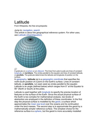
  • 1. Latitude From Wikipedia, the free encyclopedia Jump to: navigation, search This article is about the geographical reference system. For other uses, see Latitude (disambiguation). A graticule on a sphere or an ellipsoid. The lines from pole to pole are lines of constant longitude, or meridians. The circles parallel to the equator are lines of constant latitude, or parallels. The graticule determines the latitude and longitude of position on the surface. In geography, latitude (φ) is a geographic coordinate that specifies the north-south position of a point on the Earth's surface. Lines of constant latitude, or parallels, run east–west as circles parallel to the equator. Latitude is an angle (defined below) which ranges from 0° at the Equator to 90° (North or South) at the poles. Latitude is used together with longitude to specify the precise location of features on the surface of the Earth. Since the actual physical surface of the Earth is too complex for mathematical analysis, two levels of abstraction are employed in the definition of these coordinates. In the first step the physical surface is modelled by the geoid, a surface which approximates the mean sea level over the oceans and its continuation under the land masses. The second step is to approximate the geoid by a mathematically simpler reference surface. The simplest choice for the reference surface is a sphere, but the geoid is more accurately modelled
  • 2. by an ellipsoid. The definitions of latitude and longitude on such reference surfaces are detailed in the following sections. Lines of constant latitude and longitude together constitute a graticule on the reference surface. The latitude of a point on the actual surface is that of the corresponding point on the reference surface, the correspondence being along the normal to the reference surface which passes through the point on the physical surface. Latitude and longitude together with some specification of height constitute a geographic coordinate system as defined in the specification of the ISO 19111 standard.[1] Since there are many different reference ellipsoids the latitude of a feature on the surface is not unique: this is stressed in the ISO standard which states that "without the full specification of the coordinate reference system, coordinates (that is latitude and longitude) are ambiguous at best and meaningless at worst". This is of great importance in accurate applications, such as GPS, but in common usage, where high accuracy is not required, the reference ellipsoid is not usually stated. In English texts the latitude angle, defined below, is usually denoted by the Greek lower-case letter phi (φ or ɸ ). It is measured in degrees, minutes and seconds or decimal degrees, north or south of the equator. Measurement of latitude requires an understanding of the gravitational field of the Earth, either for setting up theodolites or for determination of GPS satellite orbits. The study of the figure of the Earth together with its gravitational field is the science of Geodesy. These topics are not discussed in this article. (See for example the textbooks by Torge[2] and Hofmann-Wellenhof and Moritz.[3]) This article relates to coordinate systems for the Earth: it may be extended to cover the Moon, planets and other celestial objects by a simple change of nomenclature. The following lists are available: • List of countries by latitude • List of cities by latitude Contents [hide] 1 Latitude on the sphere 1.1 The graticule on the sphere 1.2 Named latitudes 1.3 Map projections from the sphere 1.4 Meridian distance on the sphere 2 Latitude on the ellipsoid
  • 3. 2.1 Ellipsoids 2.2 The geometry of the ellipsoid 2.3 Geodetic and geocentric latitudes 2.4 The length of a degree of latitude 3 Auxiliary latitudes 3.1 Geocentric latitude 3.2 Reduced (or parametric) latitude 3.3 Rectifying latitude 3.4 Authalic latitude 3.5 Conformal latitude 3.6 Isometric latitude 4 Numerical comparison of auxiliary latitudes 5 Latitude and coordinate systems 5.1 Geodetic coordinates 5.2 Spherical polar coordinates 5.3 Ellipsoidal coordinates 5.4 Coordinate conversions 6 Astronomical latitude 7 See also 8 Footnotes 9 External links [edit] Latitude on the sphere
  • 4. A perspective view of the Earth showing how latitude (φ) and longitude (λ) are defined on a spherical model. The graticule spacing is 10 degrees. [edit] The graticule on the sphere The graticule, the mesh formed by the lines of constant latitude and constant longitude, is constructed by reference to the rotation axis of the Earth. The primary reference points are the poles where the axis of rotation of the Earth intersects the reference surface. Planes which contain the rotation axis intersect the surface in the meridians and the angle between any one meridian plane and that through Greenwich (the Prime Meridian) defines the longitude: meridians are lines of constant longitude. The plane through the centre of the Earth and orthogonal to the rotation axis intersects the surface in a great circle called the equator. Planes parallel to the equatorial plane intersect the surface in circles of constant latitude; these are the parallels. The equator has a latitude of 0°, the North pole has a latitude of 90° north (written 90° N or +90°), and the South pole has a latitude of 90° south (written 90° S or −90°). The latitude of an arbitrary point is the angle between the equatorial plane and the radius to that point. The latitude that is defined in this way for the sphere is often termed the spherical latitude to avoid ambiguity with auxiliary latitudes defined in subsequent sections. [edit] Named latitudes
  • 5. The orientation of the Earth at the December solstice. Besides the equator, four other parallels are of significance: 66° 33′ 39″ Arctic Circle N 23° 26′ 21″ Tropic of Cancer N Tropic of 23° 26′ 21″ Capricorn S 66° 33′ 39" Antarctic Circle S The plane of the Earth's orbit about the sun is called the ecliptic. The plane perpendicular to the rotation axis of the Earth is the equatorial plane. The angle between the ecliptic and the equatorial plane is called the inclination of the ecliptic, denoted by in the figure. The current value of this angle is 23° 26′ 21″.[4] It is also called the axial tilt of the Earth since it is equal to the angle between the axis of rotation and the normal to the ecliptic. The figure shows the geometry of a cross section of the plane normal to the ecliptic and through the centres of the Earth and the Sun at the December solstice when the sun is overhead at some point of the Tropic of Capricorn. The south polar latitudes below the Antarctic Circle are in daylight whilst the north polar latitudes above the Arctic Circle are in night. The situation is reversed at the June solstice when the sun is overhead at the Tropic of Cancer. The latitudes of the tropics are equal to the inclination of the ecliptic and the polar circles are at latitudes equal to its complement. Only at latitudes in between the two tropics is it possible for the sun to be directly overhead (at the zenith). The named parallels are clearly indicated on the Mercator projections
  • 6. shown below. [edit] Map projections from the sphere On map projections there is no simple rule as to how meridians and parallels should appear. For example, on the spherical Mercator projection the parallels are horizontal and the meridians are vertical whereas on the Transverse Mercator projection there is no correlation of parallels and meridians with horizontal and vertical, both are complicated curves. The red lines are the named latitudes of the previous section. Normal Mercator Transverse Mercator For map projections of large regions, or the whole world, a spherical Earth model is completely satisfactory since the variations attributable to ellipticity are negligible on the final printed maps. [edit] Meridian distance on the sphere On the sphere the normal passes through the centre and the latitude (φ) is therefore equal to the angle subtended at the centre by the meridian arc from the equator to the point concerned. If the meridian distance is denoted by m(φ) then where R denotes the mean radius of the Earth. R is equal to 6371 km or 3959 miles. No higher accuracy is appropriate for R since higher precision results necessitate an ellipsoid model. With this value for R the meridian length of 1 degree of latitude on the sphere is 111.2 km or 69 miles. The
  • 7. length of 1 minute of latitude is 1.853 km, or 1.15 miles. (See nautical mile). [edit] Latitude on the ellipsoid [edit] Ellipsoids In 1687 Isaac Newton published the Principia in which he included a proof that a rotating self-gravitating fluid body in equilibrium takes the form of an oblate ellipsoid.[5] (This article uses the term ellipsoid in preference to the older term spheroid). Newton's theoretical result was confirmed by precise geodetic measurements in the eighteenth century. (See Meridian arc). The definition of an oblate ellipsoid is the three dimensional surface generated by the rotation of a two dimensional ellipse about its shorter axis (minor axis). 'Oblate ellipsoid of revolution' is abbreviated to ellipsoid in the remainder of this article: this is the current practice in geodetic literature. (Ellipsoids which do not have an axis of symmetry are termed tri-axial). A great many different reference ellipsoids have been used in the history of geodesy. In pre-satellite days they were devised to give a good fit to the geoid over the limited area of a survey but, with the advent of GPS, it has become natural to use reference ellipsoids (such as WGS84) with centres at the centre of mass of the Earth and minor axis aligned to the rotation axis of the Earth. These geocentric ellipsoids are usually within 100m of the geoid. Since latitude is defined with respect to an ellipsoid the position of a given feature is different on each ellipsoid: it is meaningless to specify the latitude and longitude of a geographical feature without specifying the ellipsoid used. The maps maintained by many national agencies are often based on the older ellipsoids so that is necessary to know how the latitude and longitude values may be transformed from one ellipsoid to another. For example GPS handsets must include software to carry out datum transformations which link WGS84 to the local reference ellipsoid with its associated grid reference system. [edit] The geometry of the ellipsoid The overall shape of an ellipsoid of revolution is determined by the shape of the ellipse which is rotated about its minor (shorter) axis. Two parameters are required. One is invariably chosen to be the equatorial radius, which is the semi-major axis, a. The other parameter is usually taken as one of three possibilities: (1) the polar radius or semi-minor axis, b; (2) the (first) flattening, f; (3) the eccentricty, e. These parameters are
  • 8. not independent: they are related by A great many other parameters (see ellipse, ellipsoid) are used in the study of the ellipsoid in geodesy, geophysics and map projections but they can all may be expressed in terms of one or two members of the set a, b, f and e. Both f and e are small parameters which often appear in series expansions involved in practical calculations; they are of the order 1/300 and 0.08 respectively. Accurate values for a number of important ellipsoids are given in Figure of the Earth. It is conventional to define reference ellipsoids by giving the semi-major axis and the inverse flattening, 1/f. For example, the defining values for the WGS84 ellipsoid, used by all GPS devices, are[6] • a (equatorial radius): 6,378,137.0 m • 1/f (inverse flattening): 298.257,223,563 from which are derived • b (polar radius): 6,356,752.3142 m • e2 (eccentricity squared): 0.006,694,379,990,14 The difference of the major and minor semi-axes is approximately 21 km and as fraction of the semi-major axis it is given by the flattening. Thus the representation of the ellipsoid on a computer could be sized as 300px by 299px. Since this would be indistinguishable from a sphere shown as 300px by 300px illustrations invariably greatly exaggerate the flattening. [edit] Geodetic and geocentric latitudes The definition of geodetic latitude (φ) and longitude (λ) on an ellipsoid. The normal to the surface does not pass through the centre.
  • 9. The graticule on the ellipsoid is constructed in exactly the same way as on the sphere. The normal at a point on the surface of an ellipsoid does not pass through the centre, except for points on the equator or at the poles, but the definition of latitude remains unchanged as the angle between the normal and the equatorial plane. The terminology for latitude must be made more precise by distinguishing Geodetic latitude: the angle between the normal and the equatorial plane. The standard notation in English publications is φ. This is the definition assumed when the word latitude is used without qualification. The definition must be accompanied with a specification of the ellipsoid. Geocentric latitude: the angle between the radius (from centre to the point on the surface) and the equatorial plane. (Figure below). There is no standard notation: examples from various texts include ψ, q, φ', φc, φg. This article uses ψ. Spherical latitude: the angle between the normal to a spherical reference surface and the equatorial plane. Geographic latitude must be used with care. Some authors use it as a synonym for geodetic latitude whilst others use it as an alternative to the astronomical latitude. Latitude (unqualified) should normally refer to the geodetic latitude. The importance of specifying the reference datum may be illustrated by a simple example. On the reference ellipsoid for WGS84, the centre of the Eiffel Tower has a geodetic latitude of 48° 51′ 29″ N, or 48.8583° N and longitude of 2° 17′ 40″ E or 2.2944°E. The same coordinates on the datum ED50 define a point on the ground which is 140 m distant from Tower.[citation needed] A web search may produce several different values for the latitude of the Tower; the reference ellipsoid is rarely specified. [edit] The length of a degree of latitude In Meridian arc and standard texts[2][7][8] it is shown that the distance along a meridian from latitude φ to the equator is given by (φ in radians) The function in the first integral is the meridional radius of curvature. The distance from the equator to the pole is For WGS84 this distance is 10001.965729 km.
  • 10. The evaluation of the meridian distance integral is central to many studies in geodesy and map projection. It can be evaluated by expanding the integral by the binomial series and integrating term by term: see Meridian arc for details. The length of the meridian arc between two given latitudes is given by replacing the limits of the integral by the latitudes concerned. The length of a small meridian arc is roughly given by[7][8] 0 110.574 k 111.320 k ° m m 1 110.649 k 107.551 k 5 m m ° 3 110.852 k 96.486 k 0 m m ° 4 111.132 k 78.847 k 5 m m ° 6 111.412 k 55.800 k 0 m m ° 7 111.618 k 28.902 k 5 m m ° 9 111.694 k 0 0.000 km m ° When the latitude difference is 1 degree, corresponding to /180 radians, the arc distance is about The distance in metres (correct to 0.01 metre) between latitudes ( deg) and ( deg) on the WGS84 spheroid is The variation of this distance with latitude (on WGS84) is shown in the table along with the length of a degree of longitude:
  • 11. A calculator for any latitude is provided by the U.S. government's National Geospatial-Intelligence Agency(NGA).[9] [edit] Auxiliary latitudes There are six auxiliary latitudes that have applications to special problems in geodesy, geophysics and the theory of map projections: • geocentric latitude, • reduced (or parametric) latitude, • rectifying latitude, • authalic latitude, • conformal latitude, • isometric latitude. The definitions given in this section all relate to locations on the reference ellipsoid but the first two auxiliary latitudes, like the geodetic latitude, can be extended to define a three dimensional geographic coordinate system as discussed below. The remaining latitudes are not used in this way; they are used only as intermediate constructs in map projections of the reference ellipsoid to the plane: their numerical values are not of interest. For example no one would need to calculate the authalic latitude of the Eiffel Tower. The expressions below give the auxiliary latitudes in terms of the geodetic latitude, the semi-major axis, a, and the eccentricity, e. The forms given are, apart from notational variants, those in the standard reference for map projections, namely "Map projections — a working manual" by J.P.Snyder.[10] Derivations of these expressions may be found in Adams[11] and web publications by Rapp[7] and Osborne[8] [edit] Geocentric latitude
  • 12. The definition of geodetic (or geographic) and geocentric latitudes. The geocentric latitude is the angle between the equatorial plane and the radius from the centre to a point on the surface. The relation between the geocentric latitude (ψ) and the geodetic latitude (φ) is derived in the above references as The geodetic and geocentric latitudes are equal at the equator and poles. The value of the squared eccentricity is approximately 0.007 (depending on the choice of ellipsoid) and the maximum difference of (φ-ψ) is approximately 11.5 minutes of arc at a geodetic latitude of 45°5′. [edit] Reduced (or parametric) latitude Definition of the reduced latitude (β) on the ellipsoid. The reduced or parametric latitude, β, is defined by the radius drawn from the centre of the ellipsoid to that point Q on the surrounding sphere
  • 13. (of radius a) which is the projection parallel to the Earth's axis of a point P on the ellipsoid at latitude . It was introduced by Legendre[12] and Bessel[13] who solved problems for geodesics on the ellipsoid by transforming them to an equivalent problem for spherical geodesics by using this smaller latitude. Bessel's notation, , is also used in the current literature. The reduced latitude is related to the geodetic latitude by[7][8] The alternative name arises from the parameterization of the equation of the ellipse describing a meridian section. In terms of Cartesian coordinates p, the distance from the minor axis, and z, the distance above the equatorial plane, the equation of the ellipse is The Cartesian coordinates of the point are parameterized by Cayley[14] suggested the term parametric latitude because of the form of these equations. The reduced latitude is not used in the theory of map projections. Its most important application is in the theory of ellipsoid geodesics. (Vincenty, Karney[15]). [edit] Rectifying latitude The rectifying latitude, μ, is the meridian distance scaled so that its value at the poles is equal to 90 degrees or π/2 radians: where the meridian distance from the equator to a latitude φ is (see Meridian arc) and the length of the meridian quadrant from the equator to the pole is Using the rectifying latitude to define a latitude on a sphere of radius
  • 14. defines a projection from the ellipsoid to the sphere such that all meridians have true length and uniform scale. The sphere may then be projected to the plane with an equirectangular projection to give a double projection from the ellipsoid to the plane such that all meridians have true length and uniform meridian scale. An example of the use of the rectifying latitude is the Equidistant conic projection. (Snyder,[10] Section 16). The rectifying latitude is also of great importance in the construction of the Transverse Mercator projection. [edit] Authalic latitude The authalic (Greek for same area) latitude, ξ, gives an area-preserving transformation to a sphere. where and and the radius of the sphere is taken as An example of the use of the authalic latitude is the Albers equal-area conic projection. (Snyder,[10] Section 14). [edit] Conformal latitude The conformal latitude, χ, gives an angle-preserving (conformal) transformation to the sphere.
  • 15. . The conformal latitude defines a transformation from the ellipsoid to a sphere of arbitrary radius such that the angle of intersection between any two lines on the ellipsoid is the same as the corresponding angle on the sphere (so that the shape of small elements is well preserved). A further conformal transformation from the sphere to the plane gives a conformal double projection from the ellipsoid to the plane. This is not the only way of generating such a conformal projection. For example, the 'exact' version of the Transverse Mercator projection on the ellipsoid is not a double projection. (It does, however, involve a generalisation of the conformal latitude to the complex plane). [edit] Isometric latitude The isometric latitude is conventionally denoted by ψ (not to be confused with the geocentric latitude): it is used in the development of the ellipsoidal versions of the normal Mercator projection and the Transverse Mercator projection. The name "isometric" arises from the fact that at any point on the ellipsoid equal increments of ψ and longitude λ give rise to equal distance displacements along the meridians and parallels respectively. The graticule defined by the lines of constant ψ and constant λ, divides the surface of the ellipsoid into a mesh of squares (of varying size). The isometric latitude is zero at the equator but rapidly diverges from the geodetic latitude, tending to infinity at the poles. The conventional notation is given in Snyder[10] (page 15): For the normal Mercator projection (on the ellipsoid) this function defines the spacing of the parallels: if the length of the equator on the projection is E (units of length or pixels) then the distance, y, of a parallel of latitude φ
  • 16. from the equator is [edit] Numerical comparison of auxiliary latitudes The following plot shows the magnitude of the difference between the geodetic latitude, (denoted as the 'common' latitude on the plot), and the auxiliary latitudes other than the isometric latitude (which diverges to infinity at the poles). In every case the geodetic latitude is the greater. The differences shown on the plot are in arc minutes. The horizontal resolution of the plot fails to make clear that the maxima of the curves are not at 45° but calculation shows that they are within a few arc minutes of 45°. Some representative data points are given in the table following the plot. Note the closeness of the conformal and geocentric latitudes. This was exploited in the days of hand calculators to expedite the construction of map projections. (Snyder,[10] page 108). Approximate difference from geodetic latitude ( ) Reduc Autha Rectifyi Conform Geocentric ed lic ng al
  • 17. 0 0.00′ 0.00′ 0.00′ 0.00′ 0.00′ ° 1 5 2.91′ 3.89′ 4.37′ 5.82′ 5.82′ ° 3 0 5.05′ 6.73′ 7.57′ 10.09′ 10.09′ ° 4 5 5.84′ 7.78′ 8.76′ 11.67′ 11.67′ ° 6 0 5.06′ 6.75′ 7.59′ 10.12′ 10.13′ ° 7 5 2.92′ 3.90′ 4.39′ 5.85′ 5.85′ ° 9 0 0.00′ 0.00′ 0.00′ 0.00′ 0.00′ ° [edit] Latitude and coordinate systems The geodetic latitude, or any of the auxiliary latitudes defined on the reference ellipsoid, constitutes with longitude a two-dimensional coordinate system on that ellipsoid. To define the position of an arbitrary point it is necessary to extend such a coordinate system into three dimensions. Three latitudes are used in this way: the geodetic, geocentric and reduced latitudes are used in geodetic coordinates, spherical polar coordinates and ellipsoidal coordinates respectively. [edit] Geodetic coordinates
  • 18. Geodetic coordinates P(ɸ ,λ,h) At an arbitrary point P consider the line PN which is normal to the reference ellipsoid. The geodetic coordinates P(ɸ ,λ,h) are the latitude and longitude of the point N on the ellipsoid and the distance PN. This height differs from the height above the geoid or a reference height such as that above mean sea level at a specified location. The direction of PN will also differ from the direction of a vertical plumb line. The relation of these different heights requires knowledge of the shape of the geoid and also the gravity field of the Earth. [edit] Spherical polar coordinates Geocentric coordinate related to spherical polar coordinates P(r, θ, λ) The geocentric latitude ψ is the complement of the polar angle θ in conventional spherical polar coordinates in which the coordinates of a point are P(r, θ, λ) where r is the distance of P from the centre O, θ is the angle between the radius vector and the polar axis andλ is longitude. Since
  • 19. the normal at a general point on the ellipsoid does not pass through the centre it is clear that points on the normal, which all have the same geodetic latitude, will have differing geocentic latitudes. Spherical polar coordinate systems are used in the analysis of the gravity field. [edit] Ellipsoidal coordinates Ellipsoidal coordinates P(u,β,λ) The reduced latitude can also be extended to a three dimensional coordinate system. For a point P not on the reference ellipsoid (semi-axes OA and OB) construct an auxiliary ellipsoid which is confocal (same foci F, F') with the reference ellipsoid: the necessary condition is that the product ae of semi-major axis and eccentricity is the same for both ellipsoids. Let u be the semi-minor axis (OD) of the auxiliary ellipsoid. Further let β be the reduced latitude of P on the auxiliary ellipsoid. The set (u,β,λ) define the ellipsoid coordinates. (Torge[2] Section 4.2.2). These coordinates are the natural choice in models of the gravity field for a uniform distribution of mass bounded by the reference ellipsoid. [edit] Coordinate conversions The relations between the above coordinate systems, and also Cartesian coordinates are not presented here. The transformation between geodetic and Cartesian coordinates may be found in Geodetic system. The relation of Cartesian and spherical polars is given in Spherical coordinate system. The relation of Cartesian and ellipsoidal coordinates is discussed in Torge.[2] [edit]
  • 20. Astronomical latitude The astronomical latitude (Φ) is defined as the angle between the equatorial plane and the true vertical at a point on the surface: the true vertical, the direction of a plumb line, is the direction of the gravity field at that point. (The gravity field is the resultant of the gravitational acceleration and the centrifugal acceleration at that point. See Torge.[2]) The astronomic latitude is readily accessible by measuring the angle between the zenith and the celestial pole or alternatively the angle between the zenith and the sun when the elevation of the latter is obtained from the almanac. In general the direction of the true vertical at a point on the surface does not coincide with the either the normal to the reference ellipsoid or the normal to the geoid. The deflections between the astronomic and geodetic normals are only of the order of a few seconds of arc but they are nevertheless important in high precision geodesy.[2][3] Astronomical latitude is not to be confused with declination, the coordinate astronomers used in a simlilar way to describe the locations of stars north/south of the celestial equator (see equatorial coordinates), nor with ecliptic latitude, the coordinate that astronomers use to describe the locations of stars north/south of the ecliptic (see ecliptic coordinates).