Energy budgets
•Télécharger en tant que PPT, PDF•
4 j'aime•7,829 vues

AS Level Geography: global Heat Budgets

Recommandé
Contenu connexe
Tendances
Tendances (20)
Similaire à Energy budgets
Similaire à Energy budgets (20)
Plus de Guerillateacher
Plus de Guerillateacher (20)
Dernier
Dernier (20)
Energy budgets
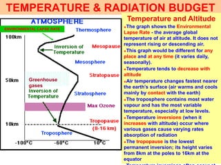
- 1. TEMPERATURE & RADIATION BUDGET Temperature and Altitude �The graph shows the Environmental Lapse Rate - the average global temperature of air at altitude. It does not represent rising or descending air. �This graph would be different for any place and at any time (it varies daily, seasonally). �Temperature tends to decrease with altitude �Air temperature changes fastest nearer the earth’s surface (air warms and cools mainly by contact with the earth) �The troposphere contains most water vapour and has the most variable temperature, especially at low levels. �Temperature inversions (when it increases with altitude) occur where various gases cause varying rates absorption of radiation �The tropopause is the lowest permanent inversion; its height varies from 8km at the poles to 16km at the equator Greenhouse gases ENVIRONMENTAL LAPSE RATE
- 2. SOLAR ENERGY - VARIATIONS� Solar energy is transmitted to earth in the form of short and long wave (SW or UV, and LW) radiation, since the sun is very hot. It is SW, UV radiation that is absorbed effectively by ozone. This is insolation. � Radiation may be absorbed only by mass; the more mass, the more absorption. � The earth also emits radiation (all bodies at a temperature above - 273°C do); this radiation is almost entirely long wave (LW) since it is cooler than the sun. This LW radiation is more effectively absorbed by greenhouse gases (CO2, � The amount of insolation emitted by the sun varies with sun spot activity. This causes fluctuations of up to 2% on a time scale of decades, or more. � The amount of insolation reaching the earth’s outer atmosphere varies with distance and variations of the earth’s orbit. This causes fluctuations of up to 4% on a time scale of centuries or more. INSOLATION is the energy which drives the atmospheric weather system. All winds, humidity and weather systems are driven by variations in temperature. Climate (long term variations in the state of the atmosphere) is related to global and continental location. Weather (short term
- 3. Low sun (as sunset) shows more red due to atmospheric dust and pollution GLOBAL VARIATIONS in INSOLATION Insolation received at the earth’s surface varies with latitude. The higher angle of the sun in the sky at the equator conveys more energy per unit area than at higher latitudes.� A given amount of radiation covers a smaller area when overhead than when at a low angle; it is more concentrated � Radiation passes through a greater length of atmosphere when at a low angle in the sky than when overhead. Atmospheric gases, dust and vapour absorb more energy before it reaches the earth’s A high sun is more effective than a sun low in the sky
- 4. DAY LENGTH Antarctic circle 66.5°S Arctic circle 66.5°N North Pole 90°N South Pole 90°N Equator 0° Tropic of Cancer 23.5°N Tropic of Capricorn 23.5°N Six months daytime (March-Sept), six months night (Sept - March) Six months daytime (Sept - March), six months night (March-Sept) One day with 24 hours daylight (June 21st); one day with 24 hours darkness (Dec 21st) One day with 24 hours daylight (March 21st); one day with 24 hours darkness (June 21st) Sun is overhead once a year (June 21st). Day length always at least 10 hours. Sun is overhead once a year (Dec 21st). Day length always at least 10 hours. Constant day length - 12 hours day and night all year round Lengths of day and night vay more between the seasons at higher latitudes. This makes climate more seasonal at the poles than the equator More season al More season al
- 5. CONTINENTAL SCALE VARIATIONS Satellite photo taken in daytime in June over Scandinavia. Warmer surfaces show darker. Note that land is darker than sea (ie land is warmer). Satellite photo taken at night over Britain in January. Warm surfaces show darker. Note that sea is darker than the land (ie sea is warmer). REASONS FOR CONTINENTAL TEMPERATURE CONTRASTS � Water has a higher specific heat than land ie: it takes more energy to heat up an equal mass of water by 1°C than it does land. Water stores heat energy more effectively than land. � Insolation is concentrated into the top few cm of the land, but is dispersed over the surface 10-20m of water. � Water loses energy through evaporation and loss of latent heat. � Turbulence causes warmer water to be mixed with colder water, so temperatures remain more constant. � Reflectivity is NOT a cause.EFFECTS � Temperatures of the sea vary less than on land � Land near the sea has temperatures moderated � The larger the ocean, the greater the effect � Land temperatures vary more; the larger the land mass, the larger the variation of temperature. � Continental scale land masses have a more
- 6. SMALL SCALE TEMPERATURE VARIATIONS ALBEDO is the reflectivity of the earth’s surface. Darker colours have a lower albedo; it absorbs more incident radiation than lighter colours. On the photo, the snowcapped mountains have the highest albedo, the forest the lowest. Ice cover at the poles has a high albedo, further reducing temperature. Water has a surprisingly low albedo, unless it is calm and the sun is at a low angle. Albedo of vegetation varies seasonally; albedo of earth varies with water content. Cloud cover also increases albedo, and changes over time. ASPECT is the angle from which the sun shines. In Europe, south facing slopes are warmer than north facing. In the southern hemisphere, the aspects are reversed. On the photo above, some snow remains on the north facing slope; none on the south facing slope. A south facing ALTITUDE causes temperature to decrease (by about 0.6°C per 100m). Air is warmed mainly by contact with the ground, so air at altitude is colder. It is also at lower pressure ( less dense) so absorbs insolation less effectively. Hence snowcapped peaks. These small scale factors vary over time. Vegetation changes daily and seasonally, with growth and human harvest. Moisture content may change the albedo. Wind and sun angle alter the albedo of water. Cloud cover also affects reflectivity; wind and rain affect evaporation rates, North facing South facing
- 7. ENERGY CASCADE - DAY DAYTIME insolation takes a variety of pathways. Incoming SW radiation is absorbed by mass, hence more effectively by the earth’s surface than by the atmosphere whose gases are much less dense. The diagram represents a global average; the figures clearly vary with the angle of the sun, day length, cloud cover, humidity, albedo, aspect and altitude. They vary from place to place and over time (seasonally, diurnally and shorter time scales).
- 8. ENERGY CASCADE -NIGHT NIGHT-TIME energy flows vary from those at daytime. Outgoing terrestrial radiation is LW (the earth is colder than the sun) and continues over 24 hours. In the day, it is usually less than the incoming solar radiation, so the earth warms up and soil heat flow is downward. At night, it is clearly greater than insolation and soil heat flow is upward. Heat is also transferred by evaporation and condensation, and by movement of warm or cold air or water (sensible heat flow) in the form of winds and ocean currents. Again, this represents a
- 9. GLOBAL HEAT FLUX � At 40°N and S, there is a balance of insolation with outgoing LW radiation over the year. � Insolation exceeds LW radiation in the daytime, and in summer; the reverse is true at night and in winter. � Polewards of 40°N and S, there is an annual heat deficit, despite periods of surplus during some days and in summer. � Equatorwards of 40°N and S, there is an annual heat surplus despite periods of deficit at night and in winter. � Without movement of heat energy, the poles would become steadily colder and colder, while the equator would get progressively warmer. This clearly does not happen. � This heat transfer (flux) occurs by:� Ocean currents; cold polar water flows towards the equator while warm water flows from equator to pole. � Winds which blow warm air to towards the poles and cold to the equator. � An excess of evaporation which takes up and stores latent heat in water vapour, releasing it
- 10. OCEAN CURRENTS Cold Sea temperature Warm Labrador current carries cold water from equator to pole down east coast of N.America Gulf Stream carries warm water from equator towards the pole, and NW Europe A similar anti-clockwise movement of warm water polewards, and cold water equatorwards can be seen in the Pacific. Cold and warm winds blow in similar fashion, though are not constrained to the oceans!
- 11. HEAT TRANSFER by HUMIDITY POLES - Precipitation exceeds evaporation at high latitudes; condensation releases latent heat stored in water vapour. EQUATOR - Evaporation exceeds condensation (and precipitation); this uses heat energy and stores it in the form of water vapour. Red shows high humidity from high rates of LATENT HEAT is also transferred from sea to land in this way. Evaporation exceeds condensation over oceans (which uses heat); condensation is greater over land, which is heated up - especially in winter.
- 12. The GREENHOUSE EFFECT, like a real greenhouse (below) is to allow heat in, but not out. Gases in the atmosphere (CO2, Methane) naturally trap outgoing LW radiation more effectively than they do incoming SW radiation. This retains heat, warming the earth’s atmosphere. GREENHOUSE EFFECT & OZONE DEPLETION Ozone traps UV (SW) radiation from reaching the earth’s surface. Human pollutants (CFCs etc) are destroying this protective layer and causing cancers of the skin in Australia - near the Antarctic hole in the Ozone layer. THE ANTARCTIC HOLE IN THE OZONE LAYER This has, over geological time, been in balance. Now, human activity is increasing such gases so the warming effect is (possibly) beyond recall. This is the