Adaptation 1D and 2D Hydraulic Models for Dimitrovgrad Serbia
1. ADAPTATION OF 1D AND 2D HYDRAULIC
MODEL CALCULATION
Location – Dimitrovgrad, Serbia
General characteristics of the bed of river Nisava at the municipality of
Dimitrovgrad
Section of Nisava river, from the border with the Republic of Bulgaria to the border of
the municipality of Dimitrovgrad has a length of 13.035 km, ie. from 130+350.50 to km
143+380.50.
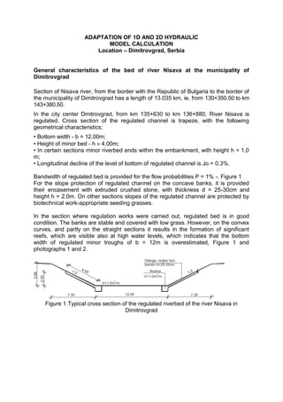
In the city center Dmitrovgrad, from km 135+630 to km 136+880, River Nisava is
regulated. Cross section of the regulated channel is trapeze, with the following
geometrical characteristics:
• Bottom width - b = 12.00m;
• Height of minor bed - h 4.00m;
• In certain sections minor riverbed ends within the embankment, with height h = 1.0
m;
• Longitudinal decline of the level of bottom of regulated channel is Jo = 0.3%.
Bandwidth of regulated bed is provided for the flow probabilities P = 1% -. Figure 1
For the slope protection of regulated channel on the concave banks, it is provided
their encasement with extruded crushed stone, with thickness d = 25-30cm and
height h = 2.0m. On other sections slopes of the regulated channel are protected by
biotechnical work-appropriate seeding grasses.
In the section where regulation works were carried out, regulated bed is in good
condition. The banks are stable and covered with low grass. However, on the convex
curves, and partly on the straight sections it results in the formation of significant
reefs, which are visible also at high water levels, which indicates that the bottom
width of regulated minor troughs of b = 12m is overestimated, Figure 1 and
photographs 1 and 2.
Obloga, redjan lom.
kamen d=25-30cm
1:2 4.5 Nozica
0 1:2
3.66
V=1.0m3/m
2.00
3
V=1.0m /m
7.30 12.00 7.30
Figure 1 Typical cross section of the regulated riverbed of the river Nisava in
Dimitrovgrad
2. Photos 1. Regulated riverbed Nišava in Dimitrovgrad
Photo 2 Bank fortification on the left concave bank and shoal on the right bank,
upstream end of regulation works carried out in Dimitrovgrad, km 136 +880
Photo 3. Regulated riverbed Nisava, bifurcation flow in the center of Dimitrovgrad
3. In the section upstream from Dimitrovgrad to the border with Republic of Bulgaria,
river Nisava flows through several hundred meters wide river valley. The valley is
formed in sandy clay and loam, on the surface is humus layer and presents a
significant arable land in this area. Major bed of the river is on the left bank limited
with local road route and the route of the international railway and road. On the right
bank, slightly undulating river valley is extending, and it is 100-600m wide.
Riverbanks are low, and inundation areas are threatened by high waters of the river
Nisava. Minor riverbed is cut into the sandy - silty - clay material on the banks, with
thickness of 1.5 - 2m, and on the bottom are expressed troughs of sand and gravel,
photos 4 and 5. Riverbanks are covered with small, and locally large plants, and on
sections where vegetation does not exist, erosion and destruction of riverbanks are
expressed.
Photo 4. Right banks of the Nisava river upstream from Dimitrovgrad, Sector IV,
The riverbed is cut into the sandy-argillaceous material, larger fractions
of sand and gravel are at depths of 1.5 - 2.0m, reefs in the riverbed
Photo 5. The appearance of inundation on the right bank, sector IV,
demolition of the concave right bank
Upstream of Dimitrovgrad regulation works have been derived in the previous period
on the section of approximately 700m length, downstream of the pedestrian bridge
4. on piles. Cross section of the regulated channel is trapeze, with the following
geometrical characteristics:
• Bottom width of minor river bed b = 7.00m;
• Height of minor bed h = 1.00m;
• Height of major bed h = 2.20m;
• Forland width bf = 1.0m;
Major riverbed is completed with embankment, the embankment crown width is
bn=1.0m, and height h 1.0m. Embankment height and bandwidth of the projected
regulated riverbed is determined by the computation of water level for the reliable
flow of probabilities P = 2%, Figure 2 Longitudinal decline of the level of bottom of
regulated channel in the whole section is Jo = 0.45%.
Derived regulation works - bank fortification of locally and orderly crushed stone on
concave banks and embankment on the right bank, are in relatively good condition.
In this section, to ensure the flow profile it is necessary only cleaning minor bed of
fine and coarse vegetation, photos 6 and 7. In relation to the projected flow profile
Figure 2, the distance between the roots of the embankment and the edge of the
minor bed is 5-8m, photo 7.
Obloga, grubo sredjen
1
1: lom. kamen d=30-50cm
1:
1:2
2.20
1
Nozica 1:2
1: 1 V=1.0m3/m
. 5
.5 1: 1
1.0 1.0
1.0 4.40 1.0 1.5 7.00 1.5 1.0 4.40 1.0
Figure 2 Typical cross section of the regulated riverbed upstream from Dimitrovgrad
Nišava
Photo 6. Performed works in the bridge zone number 2, bank fortification of crushed
aligned stone d50cm
5. Photo 7. Regulated riverbed Nisava derived regulation works downstream of the
bridge on the right concave bank, left bank is covered with dense vegetation
The main results of hydraulic calculations which are allowed from the simulation
model HEC RAS, are shown in Tables 1, 2 and 3 and the graphs 1, 2 and 3.
Flood zone for the reliable computation flow Q1% are shown on a topographic map of
R = 1:25000, graphic Attachment 1. The topographic map with cadastral situation
and flood zones, is also shown, graphic Annex 2.
Figure 3 Cross section of the riverbed Nisava and computational level of water at a
flow
Q1% Q2% Q5%, the sector I, Pr 2 (47) - km 130 +358.80
6. Figure 4 Calculating levels of water at a flow Q5%, Q2%, Q1%,
profile Pr 54 (24) - km 136 +090.80, Sector II
Figure 5 Calculating levels of water at a flow Q5%, Q2%, Q1%,
the profile of the bridge no.4 – 136+392.0 , the main part of the course and branches,
Sector III
In this sector on the right bank, are located facilities for water supply, as well as
important agricultural lands and residential and agricultural facilities, Drawings 1 and
2, Figures 7 and 8.
7. Figure 6 Calculating levels of water at a flow Q5% Q2% Q1%
profile Pr 88 (191) – km 137+579.20 , Sector IV
Figure 7 Calculating levels of water at a flow Q5% Q2% Q1%, the water intake area,
profile Pr 97 (137) - 139 +060.7 km, Sector IV