Additional Road Investments Needed to Support Oil and Gas Production and Distribution in North Dakota
•
0 likes•1,066 views

Upper Great Plains Transportation Institute, North Dakota State University Report Submitted to North Dakota Department of Commerce December 9, 2010

Recommended
More Related Content
Similar to Additional Road Investments Needed to Support Oil and Gas Production and Distribution in North Dakota
Similar to Additional Road Investments Needed to Support Oil and Gas Production and Distribution in North Dakota (20)
More from Ports-To-Plains Blog
More from Ports-To-Plains Blog (20)
Additional Road Investments Needed to Support Oil and Gas Production and Distribution in North Dakota
- 1. Upper Great Plains Transportation Institute, North Dakota State University Additional Road Investments Needed to Support Oil and Gas Production and Distribution in North Dakota* Report Submitted to North Dakota Department of Commerce December 9, 2010 * This study has been funded by the North Dakota Association of Oil & Gas Producing Counties
- 2. Table of Contents 1. Overview of Study ........................................................................................................ 10 1.1. Synopsis of Data and Methods .............................................................................. 11 1.2. Traffic Data Survey................................................................................................ 11 1.3. Traffic Counts ........................................................................................................ 11 1.4. Road Condition Data.............................................................................................. 12 1.5. Cost Data ................................................................................................................ 12 1.6. Oil-Related Data .................................................................................................... 12 1.6.1. Rig-Related Movements ................................................................................. 12 1.6.2. Production-Specific Information .................................................................... 13 1.7. Baseline Modeling ................................................................................................. 13 1.8. Forecasts ................................................................................................................ 14 1.8.1. Future Drilling Locations ................................................................................ 14 1.8.2. Private Leases ................................................................................................. 14 1.8.3. Projected Wells and Drilling Activities .......................................................... 14 1.9. Network Flow Modeling ........................................................................................ 15 1.9.1. Trip Forecasting .............................................................................................. 15 1.9.2. Assignment Function ...................................................................................... 16 2. Traffic Analysis ............................................................................................................ 17 2.1. Average Daily Trips on Major County Roads ....................................................... 17 2.2. Truck Traffic on Major County Roads .................................................................. 19 2.3. Paved and Gravel Road Traffic.............................................................................. 20 2.4. Benchmark Comparison......................................................................................... 21 2.5. Pre-existing Traffic Versus Oil Traffic .................................................................. 22 2.5.1. Theoretical Baseline Improvements ............................................................... 22 3. Paved Road Analysis .................................................................................................... 24 3.1. Key Factors ............................................................................................................ 24 3.2. Road Conditions .................................................................................................... 24 3.3. Structural Ratings................................................................................................... 24 3.4. Spring Load Restrictions........................................................................................ 27 3.4.1. Rationale for Spring Limits ............................................................................ 27 3.4.2. Typical Load Restrictions ............................................................................... 27 3.4.3. Prevalence of Restrictions in Oil-Producing Counties ................................... 29 3.4.4. Need for All-Weather Roads .......................................................................... 29 3.5. Roadway Width ..................................................................................................... 29 3.5.1. Graded Roadway Widths in Oil-Producing Counties ..................................... 30 3.5.2. Feasibility of Overlays on Narrow Roads ....................................................... 30 3.5.3. Effects of Narrow Roads on Crash Probabilities ............................................ 31 3.5.4. Effects of Narrow Roads on Capacity and Speed ........................................... 32 3.5.5. Scope of Width Issues ..................................................................................... 33 3.6. Reduced Service Lives ........................................................................................... 34 3.6.1. Measure of Pavement Life .............................................................................. 34
- 3. 3.6.2. Effects of Axle Weights .................................................................................. 35 3.6.3. ESAL Factors .................................................................................................. 35 3.6.4. Baseline ESALs .............................................................................................. 36 3.6.5. Oil-Related ESALs ......................................................................................... 37 3.6.6. Reductions in Pavement Life .......................................................................... 38 3.7. Types of Potential Improvements .......................................................................... 39 3.7.1. Reconstruction ................................................................................................ 40 3.7.2. Structural Overlay ........................................................................................... 40 3.8. Improvement Logic and Costs ............................................................................... 41 3.8.1. Improvement Selection Criteria ...................................................................... 41 3.8.2. Renewal........................................................................................................... 41 3.8.3. Improvement Costs per Mile .......................................................................... 42 3.9. Paved Road Maintenance Costs ............................................................................. 43 3.10. Estimated Paved Road Funding Needs ................................................................ 44 3.10.1. Funding Needs by Time Period .................................................................... 45 3.10.2. Funding Needs by Improvement Type ......................................................... 45 3.10.3. Funding Needs by County ............................................................................ 46 3.10.4. Effects of Investments................................................................................... 46 3.11. Impacts of Special Vehicles ................................................................................. 47 4. Unpaved Road Analysis ................................................................................................ 50 4.1. Methodology .......................................................................................................... 50 4.1.1. Classification................................................................................................... 51 4.1.2. Improvement Types ........................................................................................ 51 4.2. Results for Unpaved Roads.................................................................................... 53 4.2.1. Unpaved Road Costs by County ..................................................................... 53 4.2.2. Unpaved Road Costs by Time Period ............................................................. 53 5. Sensitivity Analysis ...................................................................................................... 56 5.1. Reconstruction of Paved Roads ............................................................................. 56 5.2. Paved Road Maintenance ....................................................................................... 57 5.3. Reconstruction of Unpaved Roads......................................................................... 57 6. Overhead Expenditures ................................................................................................. 58 6.1. Overhead Expenditures .......................................................................................... 58 7. Impacts of Inflation ....................................................................................................... 58 8. Conclusion .................................................................................................................... 59 9. Appendix A Road Condition Survey and Rating Instructions ...................................... 61 10. Appendix B County Cost and Practices Survey ......................................................... 63 11. Appendix C ESAL Factors for Specific Truck Types ................................................ 65 12. Appendix D Paved Road Maintenance Cost Model ................................................... 66 12.1. FHWA Maintenance Cost Procedure................................................................... 66 12.1.1. Current Cost Regression Model .................................................................... 66 12.1.2. Predicted Costs.............................................................................................. 66 12.2. Life-Cycle Cost Method ...................................................................................... 68 12.3. Comparison of Methods ....................................................................................... 69
- 4. 12.4. Conclusion ........................................................................................................... 69 13. Appendix E Additional Funding Needs of Oil-Impacted Unpaved Roads by County (Excluding Overhead Expenditures) ................................................................................. 70
- 5. Summary of Methods and Key Findings Oil production in North Dakota has more than doubled during the last 10 years. According to the Oil and Gas Division of the North Dakota Industrial Commission, approximately 3,300 wells were producing oil in the state prior to 2005. As of November 2010, that number had risen to 5,200. In addition, the number of producing wells is expected to increase substantially in the future. The purpose of this study is to forecast road investment needs in oil and gas producing counties of North Dakota over the next 20 years in light of the expected growth. The essential objective is to quantify the additional investments necessary for efficient year-round transportation of oil while providing travelers with acceptable roadway service. The focus is on roads owned or maintained by local governments—e.g., counties and townships. Impacts and funding needs are analyzed for three types of roads: paved, graveled, and graded and drained. The analysis is based on three main data sources: (1) oil production forecasts, (2) traffic data, and (3) county road surveys. The forecasted output of wells is routed over the road network to pipelines using a detailed Geographic Information System model in which oil movements are represented as equivalent tractor-semitrailer trips that follow least-cost paths. The projected inputs of sand and water and outbound movements of salt water to disposal sites are similarly routed. These predicted inbound and outbound movements are accumulated for each impacted segment. Afterward, oil-related trips are combined with estimates of baseline (non-oil) traffic to estimate the total traffic load on each road. The county surveys provide detailed information about the condition of each impacted segment, as well as the typical thicknesses of surface and base layers. Movements of specialized equipment (such as workover rigs) are included in the analysis. Production Forecasts. To estimate the impacts of a drilling rig moving into an area, information was collected on the locations of existing and future rigs, and the number of trucks associated with the drilling process. The existing and short-term future drilling locations were obtained from the Oil and Gas Division. The locations are based upon current rig activity and permit applications through the remainder of 2010. The future locations of drilling rigs were estimated from lease data obtained from the North Dakota Land Department. If a section is to be drilled, drilling activity will commence prior to lease expiration. In the absence of data indicating the year of the lease during which drilling will commence, it is assumed that drilling begins during the final year of the lease. In the forecast scenarios, lease expirations from 2010-2015 represent the initial drilling phase. Subsequent time periods represent the fill-in phase, wherein three to five additional wells will be placed. It is assumed that private leases will occur in the same areas as public leases. Estimates from the Oil and Gas Division suggest that a total of 21,250 wells will be drilled in the next 10 to 20 years. If 1,500 wells are drilled each year, it would take 14 years to drill the estimated 21,250 wells. Final Report Upper Great Plains Transportation Institute Additional Road Investments Needed to Support Oil & Gas Production and Distribution Page i
- 6. Trips Forecasts. Oil traffic consists largely of five types of movements: (1) inbound movements of sand, water, cement, scoria/gravel, drilling mud, and fuel; (2) inbound movements of chemicals; (3) outbound movements of oil and byproducts; (4) outbound movements of saltwater; and (5) movements of specialized vehicles such as workover rigs, fracturing rigs, cranes, and utility vehicles (i.e., rig-related movements). Origins and destinations were projected for each of the first four types. For example, a sand movement may have an origin at a rail transloading facility and a destination at a drilling site. Afterward, distances were calculated between all potential origins and destinations. Origin- destination pairs were then assigned based on the shortest path. Data on the number of trucks (by type) were compiled from information provided by the North Dakota Department of Transportation, the Oil & Gas Division of the North Dakota Industrial Council, and Missouri Basin Well Service. The total number of rig-related truck movements (movement type 5) is expected to be 2,024 per well, with approximately half of them representing loaded trips. Traffic Analysis. Traffic counters were deployed at 100 locations in 15 of the 17 oil and gas producing counties. At each of the selected sites, a count of no less than 24 hours was taken and adjusted to represent the traffic over a 24-hour period. These raw counts were adjusted for monthly variation in traffic to estimate the average daily trips (ADT) for each segment. The average traffic on these segments is 145 vehicles per day. Sixty-one of these vehicles are trucks. Twenty-six of these trucks are multi-units—i.e., semitrailer or multi-trailer trucks. Nearly 100 trucks per day travel the paved roads in this sample. The same roads are used extensively for personal travel. In effect, substantial mixing of vehicles is occurring on paved oil routes, as oil trucks and other travelers compete for the same capacity. Benchmark Traffic Comparison. Perhaps the closest benchmark for major county roads is the rural collector network of the state highway system. The average daily traffic on state collectors is roughly 277 vehicles per day, of which 17 are multi-unit trucks and 14 are single-unit trucks. In comparison, the county roads in the sample have lower ADT but higher percentages of trucks—i.e., 34 single-unit and 27 multi-unit trucks per day. The paved roads in the sample have 99 trucks per day, versus 31 trucks per day on state collectors. Structure of Paved County Roads. The capability of a road to accommodate additional truck traffic is measured through its structural number (SN), which is a function of the thickness of the surface and base layers and the materials of these layers. County roads are light-duty structures designed for farm-to-market and manufactured goods movements. They are often built with six-inch aggregate bases topped with asphalt. The total thickness of the asphalt layers ranges from 2.5 to 6 inches. The average structural numbers in oil and gas producing counties are 1.6 and 1.1 for collectors and local county roads, respectively. In comparison, the average structural number of state collectors in oil-producing counties is 2.8. Final Report Upper Great Plains Transportation Institute Additional Road Investments Needed to Support Oil & Gas Production and Distribution Page ii
- 7. There are vast differences in the expected service lives of roads with structural numbers of 1.1 and 2.8. Spring Load Restrictions. Load limits must be imposed when soils cannot effectively support heavy loads during spring. Studies have shown that soil support or modulus may be 20 to 50 percent of normal during the spring thaw and recovery period when roadbed soil is weakest. When the modulus drops during the spring, the relative damage from a load increases by 400 percent or more. This triggers weight restrictions that affect truck movements. According to surveys, 80 percent of local road and 85 percent of county collector miles in oil-producing counties are subject to 6- or 7-ton load restrictions or 65,000- pound gross vehicle weights for several weeks during the spring. Ideally, the most heavily traveled oil routes should be free from seasonal restrictions. Many of the road improvements identified in this study would remove or mitigate seasonal restrictions. Roadway Width. According to surveys, the graded widths of approximately half of the county roads in oil and gas producing areas are less than or equal to 28 feet in width. The graded width determines if a substantial new asphalt layer can be placed on top of the road without compromising its capacity. As the top of a road is elevated due to overlays, its useable width may decline. For narrower roads, this may result in reduced lane and shoulder widths and/or the elimination of shoulders. These width restrictions may affect roadway capacity (e.g., vehicles per hour) as well as safety. Effect of Roadway Width. According to a crash prediction model developed for the Federal Highway Administration, the crash rate for a two-lane road with 11-foot lanes and 2-foot shoulders is 1.38 times the crash rate for a road with 12-foot lanes and 6-foot shoulders. Moreover, the predicted crash rate for a road with 9-foot lanes and no shoulders is 1.84 times the predicted crash rate for a road with 12-foot lanes and 6-foot shoulders. As these illustrations suggest, reducing roadway width may pose safety issues. Restrictive widths may also affect capacity. Free-flow or uncongested speed is reduced by 4.7 mph for a two-lane road with 11-foot lanes and one-foot shoulders (in comparison a two-lane road with 12-foot lanes and 6-foot shoulders). For the narrowest roads with no shoulders and less than 10-foot lanes, base free-flow speed is reduced by 6.4 mph. Paved Road Service Lives. The pavement design equations of the American Association of State Highway and Transportation Officials (AASHTO) are used in this study. The equations are expressed in equivalent single axle loads or ESALs. In this metric, the weights of various axle configurations (e.g., single, tandem, and tridem axles) are converted to a uniform measure of pavement impact. With this concept, the service life of a road can be expressed in ESALs instead of truck trips. For example, the ESAL factor of an 80,000-pound tractor- semitrailer is 2.32 per mile. This means that for every loaded mile the truck travels it consumes a small part of a pavement’s life, as measured by 2.32 ESALs. In comparison, the specialized trucks used in the oil industries produce very high ESAL factors, ranging from four to ten per vehicle mile. Using design equations and ESAL factors, the service life of Final Report Upper Great Plains Transportation Institute Additional Road Investments Needed to Support Oil & Gas Production and Distribution Page iii
- 8. each impacted road is projected with and without oil traffic. The average reduction in life is five years. Williams, McKenzie, and Mountrail Counties have the most predicted miles with reduced service lives. Types of Road Improvements. Several types of potential road improvements are analyzed in this study, including reconstruction and structural overlays. A structural overlay is a cost- effective solution for pavements with substantial but lower increases in traffic. In addition to improving structural durability, reconstruction enables minor widening and shoulder improvements. In this study, oil-related impacts are estimated by comparing the selected improvement to the cost of a thin overlay, which should be sufficient for normal or baseline traffic. Reconstruction of Paved Roads. Approximately 256 miles of county road are selected for possible reconstruction. These roads are some of the most heavily impacted oil routes. Moreover, they have some of the highest baseline truck and automobile traffic volumes. The reconstruction investments identified in this study will eliminate spring load restrictions while providing paved roads that last 18 to 20 years in the face of escalating heavy truck traffic. The reconstructed and widened roads will enhance safety as a result of 12-foot lanes and shoulders. Moreover, the wider roads will reduce the interference of traffic moving in opposite directions and increase roadway capacity. Last but not least, the newly reconstructed roads will improve ride quality for all users. Structural Overlays. An additional 249 miles of paved road are candidates for structural overlays. These roads have lower projected traffic estimates than the roads selected for reconstruction. However, without thicker overlays, their life expectancies will be reduced from baseline levels. At a minimum, a thick overlay should provide for an 18-to-20-year service life with moderate oil-related traffic. It may also mitigate or lessen the severity of a spring restriction—e.g., exchange a 6-ton restriction for a less severe one. However, this outcome cannot be guaranteed. Renewal and Maintenance Costs. Renewal costs are estimated for lightly-traveled routes with less than five predicted oil trucks per day using the average cost per ESAL-mile in each county. These costs range from $0.71 to $10.26 per ESAL-mile, with an overall average of $3.46. On paved roads, maintenance costs include patching, crack sealing, and the periodic application of seal costs. The method used in this study predicts a 52 percent increase in maintenance cost when traffic increases from low to medium and a 35 percent increase when traffic grows from medium to high. Estimated Paved Road Funding Needs. The estimated paved road investment needs amount to $340 million over the next 20 years. Most (75 percent) of these needs are attributable to reconstruction, while 12 percent corresponds to both overlays and annual maintenance. Final Report Upper Great Plains Transportation Institute Additional Road Investments Needed to Support Oil & Gas Production and Distribution Page iv
- 9. Unpaved Road Analysis. The unpaved roads analyzed in this study include two primary categories: Gravel and Graded & Drained. The gravel roads represent county maintained infrastructure, while the graded and drained roads represent township infrastructure. Project selections are based on life-cycle cost comparisons. At a traffic volume of 150 vehicles per day, a paved surface (double chip seal) has a lower life-cycle cost than a gravel surface. The life-cycle costs are approximately equal for gravel and chip seal surfaces between 150 and 199 ADT. Due to the high truck percentage of traffic on impacted roads, it is assumed that the lower threshold is applicable in this study. The unpaved road sections are classified according to estimated additional truck traffic from oil development. These categories include: (1) low (0-25), (2) elevated (25-50), moderate (50-100), and high (100+). The baseline traffic for graded and drained roads and gravel roads is 15 and 50, respectively. Estimates from a 2007 survey of county road officials indicate that these assumptions are sound for baseline traffic. Graded & Drained Roads. Three improvement types are modeled for graded and drained roads: no improvement, increase gravel application, or upgrade to gravel structure. For the low-impact category, it is assumed that little additional work will be done to the road surface. For the elevated impact category, the improvement is to shorten the gravel application cycle by 50 percent. For the moderate and high impact categories, the selected improvement is upgrading the roadway to a gravel surface. Since the initial condition of graded and drained roads are often deficient with respect to roadway width, the upgrade involves regrading of the road, and addition of width to a minimum of 24 feet, and the gravel overlay. Gravel. Four improvement types are modeled for gravel roads: decreasing the blading interval, decreasing the gravel interval by 33 percent, decreasing the gravel interval by 50 percent and the application of a double chip seal to conserve and preserve aggregate. Typically, a non-impacted road has a gravel cycle of five years and a blade interval of once per month, while an impacted section has a gravel cycle of two to three years and a blade interval of twice per month. The effective difference is a doubling of the gravel maintenance costs over the same time period. On the low impact road sections, increased blading activity is implemented to maintain roadway surface condition. Reconstruction and Dust Suppressant Costs. In addition to the increases in routine maintenance on elevated and moderately impacted gravel road sections, dust suppressant and road reconstruction improvements have been identified. Currently, in the heavily impacted counties, dust suppressant is used to preserve surface aggregate and mitigate dust-related safety and health impacts. Estimates of the number of miles of currently impacted roads receiving dust treatment are consistent with reports from heavily impacted counties. The estimates for the elevated and moderate impact categories also reflect reconstruction during the first period to repair road deficiencies. These deficiencies include roadway width and structural deficiencies which, when corrected allow for 12-month operation. Final Report Upper Great Plains Transportation Institute Additional Road Investments Needed to Support Oil & Gas Production and Distribution Page v
- 10. Summary of Results. Approximately 12,718 miles of impacted unpaved roads have been identified. The projected cost of oil-related traffic on these roads is $567 million over the next 20 years (from 2011 through 2030). When the unpaved and paved road costs are added together, the projected investment need for all roads amounts to $907 million, which is equal to an average annual need of $45.35 million over the 2011-2030 period. The costs are summarized by time period in Table S.1. In columns 5 and 6, two inflation scenarios are shown to illustrate the impacts of inflation on the total needs. In these scenarios, the impacts of inflation are not modeled until the 2014-2015 biennium. In addition, costs are presented by county for the next two biennia in Tables S.2-S.4. The numbers shown do not include overhead expenditures. Table S.1 Summary of Projected Additional Funding Needs by Period (Millions of Dollars) Road Category Inflation Scenarios Biennium Unpaved Paved Total 3% Total 5% Total 2012-2013 $114.90 $118.20 $233.10 $233.10 $233.10 2014-2015 $114.90 $149.90 $264.80 $293.69 $314.20 2016-2017 $75.90 $17.00 $92.90 $109.31 $121.53 2018-2019 $36.90 $20.70 $57.60 $71.90 $83.08 2020-2021 $36.90 $10.60 $47.50 $62.91 $75.53 2022-2023 $49.10 $6.30 $55.40 $77.84 $97.12 2024-2025 $49.10 $4.70 $53.80 $80.19 $103.98 2026-2027 $37.50 $4.20 $41.70 $65.94 $88.86 2028-2029 $26.00 $4.20 $30.20 $50.66 $70.95 2030-2031 $26.00 $4.20 $30.20 $53.75 $78.22 Total $567.00 $340.10 $907.10 $1,099.30 $1,266.57 Final Report Upper Great Plains Transportation Institute Additional Road Investments Needed to Support Oil & Gas Production and Distribution Page vi
- 11. Table S.2 Additional Paved Road Costs by County: 2012-2015 ($ 2010 Million) 2012-2013 2014-2015 County 2012-2013 2014-2015 Reconstruction Reconstruction Billings $0.7 $1.8 $0.7 $1.7 Bottineau $0.2 $2.5 $0.0 $1.3 Bowman $0.1 $0.6 $0.0 $0.0 Burke $0.1 $6.4 $0.0 $6.2 Divide $3.3 $2.1 $3.2 $0.7 Dunn $6.5 $15.6 $6.3 $14.1 Golden Valley $0.9 $0.1 $0.8 $0.0 McHenry $0.0 $0.0 $0.0 $0.0 McKenzie $19.5 $33.6 $18.6 $30.7 McLean $1.7 $10.5 $1.6 $9.8 Mercer $0.0 $0.0 $0.0 $0.0 Mountrail $40.9 $29.1 $40.4 $23.9 Renville $15.8 $4.3 $15.6 $3.4 Slope $0.0 $0.0 $0.0 $0.0 Stark $7.3 $7.6 $6.9 $7.1 Ward $2.8 $13.8 $2.4 $12.3 Williams $18.4 $21.9 $17.5 $16.2 Total $118.2 $149.9 $113.9 $127.4 Final Report Upper Great Plains Transportation Institute Additional Road Investments Needed to Support Oil & Gas Production and Distribution Page vii
- 12. Table S.3 Additional Unpaved Road Costs by County: 2012-2015 ($ 2010 Million) 2012-2013 2014-2015 County 2012-2013 2014-2015 Reconstruction Reconstruction Billings $3.9 $3.9 $2.5 $2.5 Bottineau $0.8 $0.8 $0.3 $0.3 Bowman $0.5 $0.5 $0.3 $0.3 Burke $3.2 $3.2 $1.8 $1.8 Divide $9.4 $9.4 $6.0 $6.0 Dunn $17.3 $17.3 $11.8 $11.8 Golden Valley $4.3 $4.3 $2.9 $2.9 McHenry $0.1 $0.1 $0.0 $0.0 McKenzie $18.2 $18.2 $11.6 $11.6 McLean $4.0 $4.0 $2.9 $2.9 Mercer $0.2 $0.2 $0.1 $0.1 Mountrail $15.9 $15.9 $10.1 $10.1 Renville $1.9 $1.9 $1.1 $1.1 Slope $0.6 $0.6 $0.5 $0.5 Stark $8.1 $8.1 $5.7 $5.7 Ward $6.2 $6.2 $5.0 $5.0 Williams $20.2 $20.2 $13.6 $13.6 Total $114.9 $114.9 $76.3 $76.3 Final Report Upper Great Plains Transportation Institute Additional Road Investments Needed to Support Oil & Gas Production and Distribution Page viii
- 13. Table S.4 Total Projected Additional Road Costs by County: 2012-2015 ($ 2010 Million) 2012-2013 2014-2015 County 2012-2013 2014-2015 Reconstruction Reconstruction Billings $4.6 $5.6 $3.1 $4.2 Bottineau $1.0 $3.3 $0.3 $1.6 Bowman $0.6 $1.1 $0.3 $0.3 Burke $3.4 $9.6 $1.8 $8.0 Divide $12.8 $11.5 $9.3 $6.7 Dunn $23.8 $32.9 $18.0 $25.9 Golden Valley $5.2 $4.4 $3.7 $2.9 McHenry $0.1 $0.1 $0.0 $0.0 McKenzie $37.6 $51.8 $30.2 $42.4 McLean $5.7 $14.6 $4.5 $12.7 Mercer $0.2 $0.2 $0.1 $0.1 Mountrail $56.8 $45.0 $50.5 $34.0 Renville $17.7 $6.2 $16.7 $4.6 Slope $0.6 $0.6 $0.5 $0.5 Stark $15.4 $15.7 $12.6 $12.8 Ward $9.0 $20.0 $7.4 $17.3 Williams $38.6 $42.1 $31.1 $29.7 Total $233.1 $264.8 $190.1 $203.7 Final Report Upper Great Plains Transportation Institute Additional Road Investments Needed to Support Oil & Gas Production and Distribution Page ix
- 14. 1. Overview of Study Oil production in North Dakota has more than doubled during the last 10 years from 32 million barrels annually in 2000 to 80.8 million barrels through October of 2010. Much of this increase in production is attributable to higher crude oil prices and improvements in exploration and extraction technologies.1 Since 2005, the number of drilling rigs in operation has increased substantially. At the time of this writing, 163 drilling rigs were being operated in North Dakota. The Oil and Gas Division of the North Dakota Industrial Commission reported that prior to 2005, there were roughly 3,300 wells producing oil in the state. As of November 2010, the number had risen to approximately 5,200 wells. This number is estimated to increase substantially in the future. In a recent presentation, the director of the Department of Mineral Resources, Lynn Helms, stated that drilling is expected to continue for the next 10 to 20 years and estimated that an additional 21,250 wells will be drilled over this time period. According to the Oil and Gas Division, this drilling activity represents 3,000 to 3,500 long-term jobs. Bangsund and Leistritz (2009) estimated that oil development contributed 7,719 full time equivalent (FTE) positions in North Dakota in 2007. Additionally, “the petroleum industry in North Dakota was estimated to generate an additional $5.1 billion in secondary business activity, which was sufficient to support 38,500 FTE jobs.”2 The direct impacts in 2007 were estimated at $1.54 billion. The purpose of this study is to forecast road investment needs in oil and gas producing counties of North Dakota over the next 20 years in light of the expected growth. The essential objective is to quantify the additional investments necessary for efficient year- round transportation of oil while providing travelers with acceptable roadway service. The focus is on roads owned or maintained by local governments—e.g., counties and townships. The forecasted needs of state highways are developed by North Dakota Department of Transportation. State highway needs are not included in this study. The focus on oil and gas industries is justified because of their growing economic importance to the state and the potential for future job creation. The overall analysis process is highlighted in this section of the report. Detailed information on paved and unpaved road analysis procedures is included in Sections 3 and 4, respectively. More detailed information is provided in the appendices. 1 Dean Bangsund and Larry Leistritz, “Petroleum Industry’s Economic Contribution to North Dakota – 2007” North Dakota State University Agribusiness and Applied Economics Report No 639, January 2009. 2 Ibid. Final Report Upper Great Plains Transportation Institute, North Dakota State University Additional Road Investments Needed to Support Oil & Gas Production and Distribution Page 10
- 15. 1.1. Synopsis of Data and Methods The analysis is based on three main data sources: (1) oil production forecasts, (2) traffic data, and (3) county road surveys. The forecasted output of wells is routed over the road network to pipelines using a detailed Geographic Information System (GIS) model in which oil movements are represented as equivalent tractor-semitrailer trips that follow least-cost paths. The projected inputs of sand and water and outbound movements of salt water to disposal sites are similarly routed. These predicted inbound and outbound movements are accumulated for each impacted segment. Afterward, oil-related trips are combined with estimates of baseline (non-oil) traffic to estimate the total traffic load on each road. The county surveys provide detailed information about the condition of each impacted segment, as well as the typical thicknesses of surface and base layers. Movements of specialized equipment (such as workover rigs) are included in the analysis. 1.2. Traffic Data Survey The first task in the analysis was to classify road segments by traffic volume. The segments were classified by county road managers using maps obtained from the North Dakota Department of Transportation. The process is essentially as follows. A survey was sent to county managers that included detailed maps of each county with instructions to classify road sections by traffic volume: high, medium, and low. Average daily traffic (ADT) thresholds were not stipulated because relative traffic volumes vary by county. What would be considered a high-volume road in a lightly impacted county may be classified as a medium-volume road in a heavily impacted county. The initial survey response was 88 %, which was increased to 100 % after reminder calls. 1.3. Traffic Counts After identification of the high-volume roads, traffic counters were deployed at 100 locations in 15 of the 17 counties.3 The traffic counters were provided by the North Dakota Association of Oil and Gas Producing Counties and the Advanced Traffic Analysis Center of North Dakota State University.4 Two teams collected traffic data between August 9-13, 16-19, and 23-25. At each of the selected sites, a count of no less than 24 hours was taken and adjusted to represent the traffic over a 24-hour period. 3 While 100 counts were conducted, only 99 of them were used in the study. One of the count locations was mistakenly identified and turned out to be a non-impacted low-traffic road. 4 The counters used were MetroCount 5600 Vehicle Classifiers, which classify the traffic based upon a 13- vehicle classification scheme developed by the Federal Highway Administration (FHWA). Final Report Upper Great Plains Transportation Institute, North Dakota State University Additional Road Investments Needed to Support Oil & Gas Production and Distribution Page 11
- 16. 1.4. Road Condition Data On September 24, 2010, a second survey was mailed to the county contact persons. The survey (shown in Appendix A) included another set of county maps with instructions to classify the paved and gravel sections by road condition. Definitions of road condition were included to provide guidance on condition classification. The initial survey response was 100 %. County-specific condition ratings are summarized later in this report and the roadway classification scheme is described in the appendix. 1.5. Cost Data A two-page questionnaire was included in the condition survey to determine component costs and existing maintenance and improvement practices. Cost factors include the costs of gravel, trucking, placement, blading, and dust suppressant. Maintenance practices include information on gravel overlay intervals, overlay thicknesses, and blading intervals by classification: non-impacted and impacted roads. A follow-up phone survey provided the location of the pits from where gravel or scoria is obtained. The survey and instructions are presented in Appendix B. 1.6. Oil‐Related Data 1.6.1. Rig‐Related Movements Data on the number of trucks by type were compiled from input provided by the North Dakota Department of Transportation, the Oil & Gas Division of the North Dakota Industrial Council, and representatives from Missouri Basin Well Service. As shown in Table 1, the total number of truck movements is estimated to be 2,024 per well, with approximately half of them representing loaded trips. Origins and destinations were projected for each of the movements. For example, a sand movement may have an origin at a rail transloading facility and a destination at a drilling site. The existing origins of the inputs in Table 1 were obtained from the sources listed previously. Afterward, distances were calculated between all potential origins and destinations. Origin-destination pairs were then assigned based on the shortest path. Final Report Upper Great Plains Transportation Institute, North Dakota State University Additional Road Investments Needed to Support Oil & Gas Production and Distribution Page 12
- 17. Table 1. Rig Related Movements Per Well Item Number of Trucks Inbound or Outbound Sand 80 Inbound Water (Fresh) 400 Inbound Water (Waste) 200 Outbound Frac Tanks 100 Both Rig Equipment 50 Both Drilling Mud 50 Inbound Chemical 4 Inbound Cement 15 Inbound Pipe 10 Inbound Scoria/Gravel 80 Inbound Fuel trucks 7 Inbound Frac/cement pumper trucks 15 Inbound Workover rigs 1 Inbound Total - One Direction 1,012 Total Trucks 2,024 1.6.2. Production‐Specific Information Initial production (IP) rates at the county level were obtained from the Oil & Gas Division of the North Dakota Industrial Council. In the absence of forecasted production rates for each future well, it is assumed that the average IP rate by county is representative of future production rates. In addition, locations of existing oil collection points and saltwater disposal locations along with the associated volumes were used to identify the destinations of oil production and saltwater disposal trips. 1.7. Baseline Modeling The initial step in the traffic modeling process is to simulate existing movements. To this end, rig locations from July 2010 were collected from the Oil & Gas Division’s web server. Production volumes were estimated using June oil sales data obtained from the Oil & Gas Division. Using this information, and the origin points previously identified, the baseline traffic flow was simulated. Final Report Upper Great Plains Transportation Institute, North Dakota State University Additional Road Investments Needed to Support Oil & Gas Production and Distribution Page 13
- 18. 1.8. Forecasts To estimate the impacts of a drilling rig moving into an area, data were collected on the locations of existing and future rigs, and the number of trucks associated with the drilling process. The existing and short-term future drilling locations were obtained from the Oil & Gas Division. The locations are based upon current rig activity and permit applications through the remainder of 2010. 1.8.1. Future Drilling Locations The future locations of drilling rigs were estimated from lease data obtained from the North Dakota Land Department. If a section is to be drilled, drilling activity will commence prior to lease expiration. In the absence of data specifying during which year of the lease drilling activity will begin, it is assumed that drilling begins during the final year of the lease. The data provided by the Land Department includes lease expiration dates from 2010- 2015. In the forecast scenarios, the lease expirations from 2010-2015 represent the initial drilling phase. Subsequent time periods represent the fill-in phase, wherein three to five additional wells will be placed. 1.8.2. Private Leases Lease data from the North Dakota Land Department includes only public leases. It is assumed that private leases will occur in the same areas, by year, as the public leases. It is also assumed that the initial drilling on private lands will occur on a similar timeframe to drilling on public lands. To represent this assumption in the GIS model, a buffer distance is created around the public land locations to represent likely future drilling locations on private lands. 1.8.3. Projected Wells and Drilling Activities Based upon existing drilling rig numbers, it is estimated that 1,500 wells per year will be drilled. Estimates from the Oil & Gas Division suggest that a total of 21,250 wells will be drilled in the next 10 to 20 years. If 1,500 wells are drilled each year, it would take 14 years to drill the estimated 21,250 wells. However, the level and duration of drilling in each county will vary and is reflected in the forecast scenarios based upon lease expiration. Final Report Upper Great Plains Transportation Institute, North Dakota State University Additional Road Investments Needed to Support Oil & Gas Production and Distribution Page 14
- 19. 1.9. Network Flow Modeling The baseline truck flows from oil rigs and wells are simulated using existing data obtained from the Oil & Gas Division. Truck trips are estimated from the projected locations of wells and rigs. The model is run for six scenarios. In the first scenario the model is run with existing traffic. The other five scenarios reflect incremental traffic generated from wells and rigs in future years. Sets of potential origins and destinations are identified from the data sources previously described. In the analysis, an oil well is both an origin and destination. The well attracts inbound movements of sand, water and other inputs, and generates (or produces) truck trips to pipelines. While the locations of the wells, pipeline heads, and inputs are known, the actual trips between each origin and destination are unknown. The essential objective of the GIS model is to predict and route these trips. The GIS network includes federal, state and county roads. Some of the link attributes are posted speed, functional class, and surface type. The Cube© modeling software is used to build the freight flow model. The model has been run for a number of scenarios: baseline, 2011, 2012, 2013, 2014, 2015, 2016-2020, 2021-2025, 2026-2029. 1.9.1. Trip Forecasting In the GIS model, wells serve as attractors of water, sand, pipe and other inputs. Conversely, the source locations of sand, pipe, and other inputs serve as trip generators. For example, the designated locations to draw water (which were obtained from shape files provided by NDDOT) serve as trip production locations. The data needed to construct water, sand, and other shape files were provided by the North Dakota Department of Transportation. Trip attractions were estimated from records available from the Oil & Gas Division. The trip production and attraction estimates were initially used in a gravity model to generate an origin-destination (OD) trip table. However, this method failed to yield satisfactory results because of the complexity of the movements. Instead, a distance matrix was used to find the shortest distance for each production-attraction pair and an OD matrix was then estimated. In the final step, rig- specific input and output OD data were converted to truck OD data using payload values for each truck. Final Report Upper Great Plains Transportation Institute, North Dakota State University Additional Road Investments Needed to Support Oil & Gas Production and Distribution Page 15
- 20. 1.9.2. Assignment Function The estimated oil trip matrix is converted into truck trips using the truck mix and payload information described earlier. This estimated OD matrix is assigned to the highway network using “all or nothing” assignments, based on least-cost paths. The cost function used in the assignment is: C f ( d , t , p ). In this function, C represents the cost in dollars to haul one ton one mile, d is the length of the roadway segment in miles, t is the travel time over the segment (which is computed as the distance divided by the speed limit), and is the weighted payload of the truck mix used. The assignment function considers the distances of alternative routes, as well as the expected travel times over these routes. To implement this assignment, the average trucking cost is separated into two components: (1) mileage-related costs that vary with distance, and (2) time-related costs such as driver wages and opportunity costs.5 Because of this distinction, a shorter route with a lower speed limit may not be selected. The actual equation used in the assignment process is shown below cd d ct t C pl Where = per mile trucking cost excluding labor and = the cost of labor per hour. The purpose of this section of the report was to preview the analysis methods and data used in the study and describe the overall forecasting and modeling process. The results of the traffic surveys conducted in oil-producing counties are highlighted next. 5 These unit costs were estimated from a truck cost model developed by Mark Berwick of the Upper Great Plains Transportation Institute. The model is maintained and updated by UGPTI. Final Report Upper Great Plains Transportation Institute, North Dakota State University Additional Road Investments Needed to Support Oil & Gas Production and Distribution Page 16
- 21. 2. Traffic Analysis In Phase I of the survey, county road managers were provided with detailed maps and asked to classify road segments into three groups: high, medium and low traffic volumes. Using information from the surveys, traffic counts were conducted at locations identified as heavy traffic areas. These counts were taken during August of 2010.6 2.1. Average Daily Trips on Major County Roads Ideally, traffic counts taken during a particular month should be adjusted for monthly variance based on histories of traffic counts taken on roads of similar classification during other months of the year. Monthly traffic factors for major county collectors estimated by North Dakota Department of Transportation are used for this purpose (Figure 1).7 In this adjustment process, raw traffic counts are divided by 1.2—the ratio of August to average annual monthly traffic. The adjusted average daily trips (ADT) from the collection points are summarized in Table 2, by county. In this table, the number of counts (N), mean trips, and minimum and maximum values are listed. As the table shows, traffic was counted and classified at 12 locations in Mountrail County. The resulting average for the 12 segments is 134 vehicles per day. The minimum number of vehicles is 40, while the maximum number is 475. With the exception of the bottom row, other rows of Table 2 are interpreted in a similar manner. The mean value of the last row is the overall mean for all 99 locations. Similarly, the minimum and maximum values of the bottom row reflect the extreme values of all 99 locations. 6 While the sample may be representative of heavily impacted county roads in oil-producing regions, it is not a random sample. In order to draw a random sample, the population of county road segments must be clearly defined. At this time, a clearly defined population of road segments does not exist because counties do not use a uniform linear referencing system. Moreover, comprehensive information on the population miles of road in various traffic categories (e.g., low, medium, and high traffic) and structural classifications (e.g., low, medium, and high structural numbers) does not exist. Although the sample is useful for this study, the results cannot be generalized or extrapolated. 7 North Dakota Department of Transportation: North Dakota 2009 Traffic Report, 29. Final Report Upper Great Plains Transportation Institute, North Dakota State University Additional Road Investments Needed to Support Oil & Gas Production and Distribution Page 17
- 22. 1.2 1.0 0.8 0.6 0.4 0.2 0.0 Jan Feb Mar Apr May Jun Jul Aug Sep Oct Nov Dec Figure 1 Monthly Traffic Factors for County Major Collectors Table 2. Average Daily Traffic on Major County Roads County N Minimum Mean Maximum Billings 9 9 63 135 Bottineau 3 218 287 326 Bowman 6 48 202 446 Burke 6 14 50 158 Divide 3 84 178 303 Dunn 10 29 133 491 Golden Valley 5 45 91 211 McHenry 4 38 137 371 McKenzie 12 44 191 449 Mercer 3 18 23 28 Mountrail 12 40 134 475 Slope 4 24 47 73 Stark 5 38 105 334 Ward 6 75 405 724 Williams 11 23 133 613 All 99 9 145 724 Final Report Upper Great Plains Transportation Institute, North Dakota State University Additional Road Investments Needed to Support Oil & Gas Production and Distribution Page 18
- 23. 2.2. Truck Traffic on Major County Roads The average number of trucks per day and the minimum and maximum values for each county are shown in Table 3. These values are included in the total vehicle counts in Table 2. Again, using Mountrail County as an example, the average count is 65 trucks per day for the 12 sample segments. The minimum value is 12, while the maximum value is 252. Table 3. Average Trucks per Day on Major County Roads County N Minimum Mean Maximum Billings 9 4 31 80 Bottineau 3 48 68 86 Bowman 6 30 125 233 Burke 6 4 22 66 Divide 3 28 96 172 Dunn 10 12 61 198 Golden Valley 5 23 38 50 McHenry 4 7 21 40 McKenzie 12 14 97 253 Mercer 3 1 3 6 Mountrail 12 12 65 252 Slope 4 7 17 34 Stark 5 9 26 62 Ward 6 24 105 217 Williams 11 10 68 312 All 99 1 61 312 In Table 4, truck volumes are expressed as percentages. In the second column, the number of trucks is expressed as a percent of total vehicles. Values in this column are computed by dividing Column 4 of Table 3 by Column 4 of Table 2. In the third column of Table 4, semitrailer and multi-trailer trucks are expressed as percentages of total trucks. For example, trucks represent 49% of the average daily traffic collected at the 9 locations in Billings County. Of these trucks, 23% (or 11% of all vehicles) consist of semitrailer and multi-trailer trucks—referred to as multi-units. Moreover, trucks represent 42% of all vehicles at all locations, while multi-unit trucks represent 44% of all trucks and 18 to 19% of all vehicles. The traffic summary indicates the following key points: Final Report Upper Great Plains Transportation Institute, North Dakota State University Additional Road Investments Needed to Support Oil & Gas Production and Distribution Page 19
- 24. The average traffic on major county roads in oil-producing counties is 145 vehicles per day The average truck traffic on these roads is 61 trucks per day The average number of semitrailer and multi-trailer trucks is 26 per day. Table 4. Percent Trucks and Multi-Unit Trucks on Major County Roads County Trucks as a Percent of ADT Multi-Units as a Percent of Trucks Billings 49 23 Bottineau 24 38 Bowman 62 24 Burke 43 72 Divide 54 63 Dunn 46 46 Golden Valley 42 31 McHenry 15 38 McKenzie 51 52 Mercer 14 8 Mountrail 49 49 Slope 37 28 Stark 24 42 Ward 26 35 Williams 51 56 All 42 44 2.3. Paved and Gravel Road Traffic Seventy-eight of the traffic samples are graveled roads. The remaining 21 are paved surfaces. Generally, the paved roads in the sample have substantially higher average daily trips (ADT), average daily truck trips, and average daily multi-unit trips (Table 5). The median ADT values are 213 and 67 for paved and graveled roads, respectively. In comparison, the respective mean ADT values are 268 and 113. As this comparison suggests, the sample is skewed with some of the roads experiencing relatively high traffic volumes. This inference is clear from the upper quartiles of the distribution.8 Of paved roads, 25% have 372 or more average daily trips. In comparison, 8 The upper quartile is the value below which 75 percent of the observations lie. Conversely, 25% of the observations have values greater than or equal to the upper quartile. These observations are referred to as the upper quarter of the distribution. Final Report Upper Great Plains Transportation Institute, North Dakota State University Additional Road Investments Needed to Support Oil & Gas Production and Distribution Page 20
- 25. 25%of graveled roads have 121 or more average daily trips. Of the paved roads, 25% have 147 or more trucks per day. In comparison, 25% of graveled roads have 55 or more trucks per day. Table 5. Sample Traffic Statistics for Gravel and Paved County Roads Graveled Roads Paved Roads Truck Multi Truck Multi Statistic ADT ADT Units ADT ADT Units Mean 113 52 24 268 99 38 Minimum 9 1 0 46 10 1 Lower Quartile 46 14 4 116 39 10 Median 67 32 11 213 82 35 Upper Quartile 121 55 26 372 147 53 Maximum 613 312 226 726 253 171 As Table 5 suggests, roads in the top quarter of the sample experience relatively high traffic volumes. Nearly 100 trucks per day travel the paved roads in the sample. Moreover, the same paved roads are used extensively for personal travel. At the upper quartile, 225 of the 372 average daily trips on paved roads consist of automobiles, vans, buses, and light vehicles. As this statistic suggests, substantial mixing of vehicles is occurring on paved oil routes, as oil trucks and other travelers compete for the same capacity. 2.4. Benchmark Comparison Perhaps the closest benchmark for major county roads is the rural collector network of the state system. The average daily traffic on state collectors is roughly 277 vehicles per day, with an average of 11%trucks.9 Roughly 55%of these trucks are semitrailer or multi-trailer units. These percentages equate to 17 multi-unit and 14 single-unit trucks per day. In comparison, the major county roads included in this survey have lower ADT but higher percentages of trucks, resulting in 34 single-unit and 27 multi-unit trucks per day. Moreover, the paved roads in the sample (which may be a more appropriate basis for comparison) have 99 trucks per day, versus 31 trucks per day for state collector highways. 9 The statistics in this paragraph have been computed from the 2009 Highway Performance Monitoring System (HPMS) sample of the North Dakota Department of Transportation. The statistics are weighted by the lengths of the sample segments. Final Report Upper Great Plains Transportation Institute, North Dakota State University Additional Road Investments Needed to Support Oil & Gas Production and Distribution Page 21
- 26. 2.5. Pre‐existing Traffic Versus Oil Traffic To quantify additional investment needs, it is necessary to distinguish between pre-existing (baseline) traffic and oil-related traffic. This is one of the most challenging tasks of the study because libraries of traffic counts do not exist for county roads. A January 2008 survey is used to shed light on baseline traffic proportions. In this survey, (which is reflective of 2007 traffic) counties were asked to provide average ADT and percent trucks for major county collectors and local county roads. The weighted-average percent truck on collector roads in the oil-producing counties that responded to the survey was 18%. In comparison, the percentage of trucks from the 2010 traffic counts in those same counties is 39%. It may be inferred from this comparison that the proportion of trucks in the traffic stream has increased significantly since 2007 in oil-producing counties. Ideally, the pre-existing traffic estimates should reflect the truck traffic that existed before oil development—e.g., traffic that existed in 2005. However, 2005 county road data are not available for this study. While the comparison presented above is imperfect, it is the only quantitative method of establishing a baseline traffic level. Admittedly, 2007 data reflect the early days of oil development. As a result, the baseline truck proportion may be inflated. However, the impacts of such inaccuracies on the conclusions of this report will be minor unless the baseline truck percentage is substantially in error. 2.5.1. Theoretical Baseline Improvements As noted earlier, the estimates presented in this report represent the additional costs or funding needs attributable to growth in oil traffic. They do not include baseline costs incurred by counties prior to substantial growth of oil traffic. Baseline costs reflect the resurfacing and road maintenance costs typically incurred before major growth in oil- related traffic—e.g., costs for years 2005 and prior. The additional needs are estimated upon a theoretical baseline. This means that the theoretical baseline estimates presented represent the types of improvements that would be required to maintain or improve the current system condition. The theoretical baseline assumes a funding level in excess of current funding levels. Additionally, evidence suggests that this degree of improvement and maintenance is not currently being completed at the county level. Final Report Upper Great Plains Transportation Institute, North Dakota State University Additional Road Investments Needed to Support Oil & Gas Production and Distribution Page 22
- 27. To estimate oil-related impacts the selected paved roadway improvements are compared to the cost of a thin overlay ($140,000 per mile).10 This cost reflects a layer depth of 2.25 inches, which should be sufficient for normal or baseline traffic. For gravel roads, the non- impacted survey responses were used to calculate the theoretical baseline needs. To estimate the theoretical baseline for unpaved roads in the impacted counties, county responses to the cost and practices survey were used. In addition, responses from a 2008 county survey were used to clarify the responses. In the costs and practices survey, respondents were asked to define the graveling and maintenance activities for both impacted and non-impacted roads. The responses on non-impacted roads reflect maintenance practices in areas where oil development is not present, and therefore a representative baseline maintenance schedule. In counties where respondents indicated that all of the roads were impacted, responses from the 2008 survey were used, and indexed using the North Dakota Department of Transportation cost index. The traffic counts will be referred to in subsequent sections of the report. Now, the discussion turns to analysis methods. As noted in the introduction, oil-attributed impacts are analyzed for three types of roads: paved, graveled, and graded and drained. The paved road analysis is presented next. The discussion begins with an overview of the factors driving the investment forecasts and concludes with projections of the paved-road funding levels needed to support continued oil development during the next 20 years. In between, the key models and procedures used in the analysis are described, as well as the types of improvements envisioned. 10 North Dakota Department of Transportation work papers. Final Report Upper Great Plains Transportation Institute, North Dakota State University Additional Road Investments Needed to Support Oil & Gas Production and Distribution Page 23
- 28. 3. Paved Road Analysis 3.1. Key Factors Two factors are especially important in analyzing the capabilities of paved roads to accommodate additional truck traffic: the current condition and the structural rating, which is measured through the structural number (SN). The structural number is a function of the thickness of the surface and base layers and the materials of these layers. The surface layer is typically composed of asphalt while the base layer is comprised of aggregate material. The amount of cracking and deterioration of the surface layer is considered in the structural number of an aging pavement. Moreover, the conditions of base layers and underlying soils are important considerations when assessing seasonal load limits and the year-round capabilities of roads. The graded width indicates to what extent the surface of a road can be further elevated during resurfacing without substantial loss of lane and/or shoulder width. 3.2. Road Conditions Approximately 958 miles of impacted paved roads have been identified (Table 6) According to the surveys, 58% of these miles are in good or very good condition.11 Another 35% are in fair shape. Only 7% of these miles are in poor or very poor condition (Table 7). However, because of the structural characteristics of these roads, the 35% of miles currently in fair condition will deteriorate quickly. 3.3. Structural Ratings The typical base and surface layers of county major collectors in oil-producing counties are shown in Table 8 (Columns 2 and 3, respectively).12 The associated structural numbers are shown in Column 4. Similar information is shown for local county roads in Table 9. 11 The condition rating scale is shown in Appendix A. It is based on the Present Serviceability Rating (PSR), except that very good roads are rated one instead of four as in the PSR. In the survey scale, a pavement with a condition rating of one is considered “very good.” A pavement with a condition rating of two is considered “good.” A pavement with a condition rating of three is considered “fair.” A pavement with a condition rating of four is considered “poor”, while a pavement with a condition rating of five is considered “very poor.” 12 Some counties did not respond to this questionnaire. Consequently, results are not shown for all counties. At the time of this survey, some counties (such as Bowman) had few if any miles of paved road. Final Report Upper Great Plains Transportation Institute, North Dakota State University Additional Road Investments Needed to Support Oil & Gas Production and Distribution Page 24
- 29. Table 6. Miles of Paved Road Impacted by Oil-Related Traffic County Miles Billings 27 Bottineau 120 Bowman 42 Burke 45 Divide 23 Dunn 32 Golden Valley 11 McHenry 29 McKenzie 131 McLean 15 Mountrail 103 Renville 82 Stark 50 Ward 99 Williams 148 Total 958 Table 7. Conditions of Impacted Paved Roads Percent Cumulative Cumulative Road Condition Miles Miles Miles Percent Very Good 60.8 6.3% 60.8 6.3% Good 496.1 51.8% 556.9 58.1% Fair 333.6 34.8% 890.5 92.9% Poor 38.2 4.0% 928.7 96.9% Very Poor 29.7 3.1% 958.4 100% The structural numbers in these tables apparently reflect coefficients of 0.10 or less per inch of base layer, while the surface layer coefficients range from 0.25 to 0.40. A badly deteriorated surface layer is likely to be assigned a lower coefficient.13 Although Mountrail 13 The pavement design guide of the American Association of State Highway and Transportation Officials (AASHTO, 1993) suggests the use of asphalt surface coefficients ranging from 0.15 to 0.40 for in-service pavements, based on the extent of longitudinal patterned (e.g., alligator) cracking and transverse cracks. As a point of reference, a new asphalt surface is typically assigned a structural coefficient of 0.44. For aggregate base layers, the AASHTO guide suggests using coefficients of 0.0 to 0.11, depending upon the extent of degradation and contamination of aggregates with fine soil particles or abrasions. Final Report Upper Great Plains Transportation Institute, North Dakota State University Additional Road Investments Needed to Support Oil & Gas Production and Distribution Page 25
- 30. County did not report an average structural number, it is probably no greater than 1.2 (e.g., 6 inches of base × 0.10 + 2.5 inches of asphalt × 0.25). Table 8. Typical Structure of Paved County Major Collectors County Base Thickness (in.) Surface Thickness (in.) Structural Number Golden Valley 6.0 6.0 2.1 McHenry 2.0 5.0 1.5 McKenzie 6.0 4.5 1.7 McLean 4.0 4.0 1.0 Mercer 6.0 4.0 1.6 Mountrail 6.0 2.5 . Renville 4.5 4.5 1.4 Stark 6.0 5.0 2.1 Ward 6.0 5.0 1.7 Table 9. Typical Structure of Paved County Local Roads County Base Thickness (in.) Surface Thickness (in.) Structural Number McHenry 2.0 4.0 1.2 McKenzie 4.0 4.0 1.4 McLean 3.0 3.0 . Mercer 6.0 4.0 1.6 Mountrail 6.0 2.5 . Renville 4.5 4.5 1.4 Stark 6.0 1.5 0.9 Ward 4.0 3.5 1.1 When the structural numbers in Tables 8 and 9 are weighted by miles of road, the resulting averages are 1.6 and 1.1 for county major collectors and local county roads, respectively. To put these values in perspective, the structural numbers of state collectors and minor arterials in oil-producing counties are roughly 2.8 to 2.9.14 In this comparison, structural numbers cannot be gauged on a linear scale. The relationship between the service life of a road and its structural number is a fourth power function. There are vast differences in the expected service lives of roads with structural numbers of 1.1 and roads with structural numbers of 2.8. 14 These statistics have been computed from the 2009 Highway Performance Monitoring System (HPMS) sample of the North Dakota Department of Transportation for the 17 oil-producing counties. The statistics are weighted by the lengths of the sample segments. Final Report Upper Great Plains Transportation Institute, North Dakota State University Additional Road Investments Needed to Support Oil & Gas Production and Distribution Page 26
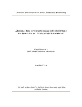
- 31. 3.4. Spring Load Restrictions In pavement analysis, soil characteristics are analyzed through variations in resilient modulus, which is a measure of the resilience or elastic properties of soils under repeated loadings. Resilient modulus—which is measured in pounds per square inch (psi)—varies significantly during the year. Studies have shown that the retained modulus may be 20% to 50% of normal modulus during the spring thaw and recovery period when roadbed soil is weakest (AASHTO, 1993).15 3.4.1. Rationale for Spring Limits Load limits must be imposed when soils cannot effectively support heavy loads during spring. The technical rationale is illustrated in Figure 2, which shows the relative damage caused by loads at various levels of soil support. In this figure, modulus is shown in thousand psi (or ksi). Typical variations during the year are shown in Figure 3 for 24 periods.16 The modulus typically lies between 6,000 and 12,000 psi during summer and early fall, but rises above 12,000 during winter when soils are frozen. Spring is a major concern, when the modulus of poor soils may drop below 5,000. When the modulus drops from 12,000 to 6,000 psi the relative damage from a load increases by 400 percent. When the modulus drops from 6,000 to 3,000 psi, the relative damage from a load increases by another 400 percent. 3.4.2. Typical Load Restrictions Typically, the tandem axles of an 80,000-pound tractor-semitrailer weigh 34,000 pounds each. However, under a 7-ton load restriction, each of the tandem axles is restricted to 28,000 pounds. This means that the truck must run with a reduced load of as much as 12,000 pounds. Under a 6-ton load restriction, each of the tandem axles is restricted to 24,000 pounds. This means that the truck must run with a reduced load of as much as 20,000 pounds. 15 American Association of State Highway and Transportation Officials (AASHTO), Guide for the Design of Pavement Structures, 1993. 16 Figure 3 is drawn from tabular data presented in the Washington State Department of Transportation’s manual WSDOT Pavement Guide, Volume 2–Pavement Notes for Design, Evaluation and Rehabilitation, (1995) 5-41,. The data are most typical of poorer quality soils that may be susceptible to moisture. The timing of the peaks and troughs in the figure may vary from year to year with the pace of temperature changes. Final Report Upper Great Plains Transportation Institute, North Dakota State University Additional Road Investments Needed to Support Oil & Gas Production and Distribution Page 27
- 32. 1.00 Relative Damage Index e at e a age de 0.80 0.60 0.40 0.20 0.00 3 4 5 6 7 8 9 Soil R Resilient Modu ulus (ksi) Figure 2 Relative Dam mages from Ve ehicle Loads a Various Lev of Soil Su at vels upport 25 20 Resilient Modulus (ksi) 15 10 5 0 Jan.1 Jan.2 Feb.1 Feb.2 Apr.1 Apr.2 May.1 May.2 Jun.1 Jun.2 Jul.1 Jul.2 Jul 2 Aug. Sep.1 Sep.2 Oct.1 Oct.2 Mar 1 Mar.1 Mar.2 Aug.2 Nov.1 Nov.2 Dec 1 Dec.1 Dec.2 Fig gure 3 Typical Variations in Soil Resilie Modulus d i ent during Year Sprin load restrictions typ ng pically last 6 to 8 wee eks; dependi on the underlying soil ing condditions. Duri this inte ing erval, the re educed payl loads attribu utable to low load lim wer mits resul in econom costs to producers. lt mic p Final Rep port Upper Great Plains Transpo P ortation Institut North Dako State Unive te, ota ersity Additiona Road Invest al tments Needed to Support Oil & Gas Produ l uction and Dist tribution Pag 28 ge
- 33. 3.4.3. Prevalence of Restrictions in Oil‐Producing Counties As shown in Tables 10 and 11, 80% of local road and 85% of collector road miles in oil- producing counties are subject to 6- or 7-ton load restrictions or 65,000-pound gross vehicle weights for several weeks during the spring. These restrictions result in reduced payloads and/or diversions of trucks to other roads. While spring limits may increase costs for a variety of road users, they are most problematic for continuous oilfield operations. Table 10. Percent of Local Road Miles Subject to Spring Load Restrictions Spring Limits Percent Cumulative Percent 6 ton 44 44 65,000 lb. gross vehicle weight 5 49 7 ton 32 80 Table 11. Percent of County Collector Road Miles Subject to Spring Load Restrictions Spring Limits Percent Cumulative Percent 6 ton 44 44 65,000 lb. gross vehicle weight 8 52 7 ton 33 85 3.4.4. Need for All‐Weather Roads Ideally, the most heavily traveled oil routes should be free from seasonal load restrictions. Many of the road improvements identified in this study would allow the removal of spring restrictions. The all-weather routes resulting from these investments would benefit farmers and other industries. Moreover, the ride quality would improve for all users, since travelers must no longer utilize rough roads damaged during spring thaw. 3.5. Roadway Width Graded width is an important factor in assessing investment needs. Width affects many aspects of roadway performance including capacity (e.g., vehicles per hour) and safety. Moreover, the graded width determines the feasibility of placing additional pavement layers on top of the existing surface without compromising performance and serviceability. Final Report Upper Great Plains Transportation Institute, North Dakota State University Additional Road Investments Needed to Support Oil & Gas Production and Distribution Page 29
- 34. 3.5.1. Graded Roadway Widths in Oil‐Producing Counties In a 2008 survey, counties were asked to provide a range of graded widths and/or a typical or average value.17 The results are shown in Table 12 for local and county major collector roads. As the table indicates, many county roads are less than or equal to 26 feet in width. Many additional road segments are only 28 feet wide. Table 12. Graded Widths (in feet) of County Roads in Oil-Producing Counties Local Roads Collectors County Low High Low High Burke 24 30 28 36 Divide 20 24 24 34 Golden Valley 24 28 28* 28* McHenry 22 26 28 34 McKenzie 20 24 28* 28* McLean 22 26 28* 28* Mercer 28 34 28 34 Mountrail . 28 . 28 * * Renville 28 28 32* 32* Slope 24* 24* 28* 28* Stark 22* 22* 24* 24* Ward 28 32 28 36 * Williams 28 28 32 32 *Typical value given in survey. Assumed to apply to both low and high widths. 3.5.2. Feasibility of Overlays on Narrow Roads The graded width determines if a substantial new asphalt layer can be placed on top of the road without compromising its capacity. As the top of the road is elevated due to overlays, a cross-sectional slope must be maintained.18 Consequently, the useable width may decline. Typically, this is not an issue for wider roads (e.g., 34-feet or more in width). However, for narrower roads, it may result in reduced lane and shoulder widths and/or the elimination of shoulders. In the ultimate case, the narrowest roads cannot be resurfaced. 17 The survey explicitly asked for graded width, not top width. 18 Roads are “crowned” or elevated in the center primarily for drainage. With a cross-sectional slope, water readily drained off the crowned surface and into the ditches. Final Report Upper Great Plains Transportation Institute, North Dakota State University Additional Road Investments Needed to Support Oil & Gas Production and Distribution Page 30