Explore Euclid's Mt. Baldy
•Télécharger en tant que PPTX, PDF•
1 j'aime•1,926 vues

Mt. Baldy is a unique Euclidian Place, well known from afar but rarely visited. Access is private and the precipice is dangerous. The place name has changed through the years. First called Long Point, it later became Old Baldy. More common now is Mt. Baldy. The actively eroding shale cliff provides a window onto the Late Devonian Age of Fishes sea bottom of 370 million years ago. Mt Baldy seems firmly in place, but it formed just 14,000 years ago and, in geological time, is rapidly mass wasting into Euclid Creek.

Recommandé
Contenu connexe
Tendances
Tendances (20)
Similaire à Explore Euclid's Mt. Baldy
Similaire à Explore Euclid's Mt. Baldy (20)
Plus de Bluestone Heights
Plus de Bluestone Heights (20)
Dernier
Dernier (20)
Explore Euclid's Mt. Baldy
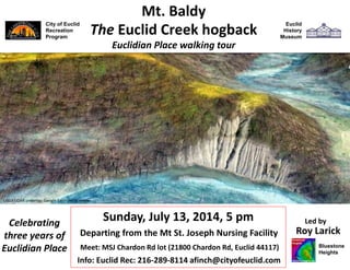
- 1. City of Euclid Recreation Program Sunday, July 13, 2014, 5 pm Roy Larick Mt. Baldy Euclidian Place walking tour Utopia Beach Arcadia Beach Info: 216-289-8114 afinch@cityofeuclid.com Explore Euclid’s Mt Baldy! The Euclid Creek hogback Google Earth aerial viewer Celebrating three years of Euclidian Place Led by Bluestone Heights Euclid History Museum USGS LiDAR underlay; Google Earth aerial viewer
- 2. About 14,000 years ago, two streams of glacial melt water broke through the Euclid Moraine. They quickly carved Euclid Creek’s main and east branch gorges through the soft shale bedrock. The Mt. Baldy bedrock peninsula remains between to encroaching meander cut banks. Mt. Baldy USGS LiDAR underlay; Google Earth aerial viewer City of Euclid City of Richmond Hts Welsh Woods ½ mi Euclid Cemetery Mt. St. Joseph © 2014 Bluestone Heights Lourdes Shrine Mt. Baldy at the confluence of Euclid Creek’s main and east branches
- 3. Mt. Baldy location Mt. Baldy in the Bluestone Heights bedrock sequence Lying just below the Euclid bluestone, Mt. Baldy is part of the lower, steeper bedrock landforms of the Portage Escarpment. On Cleveland’s East Side, Mt. Baldy is a prominent landform of the Bluestone Heights.
- 4. Mt. Baldy in the Euclid landscape In the local bedrock sequence, Mt. Baldy is a relatively high landform. It exposes two of our more important local shale bedrock units, the Chagrin and Cleveland Formations. To the south, Richmond Heights lies directly on the Euclid bluestone terrace. To the north, the Euclid Moraine lies atop the terrace.
- 5. Looking northeast, up the Mt. Baldy hogback Atop the feature, a cap of Cleveland Shale forms a flat summit (yellow). The summit is quickly falling 145 ft into the creek. Mt. Baldy, looking northeast USGS LiDAR underlay; Google Earth aerial viewer Euclid Creek’s east branch slowly cuts into the south slope As the branches combine, their full force quickly cuts into the north slope
- 6. Mt. Baldy shale cliff, looking E from Highland Rd D. Lawrence Chagrin Shale Cleveland Shale Mt. Baldy exposes 145 ft of bedrock deposited 370 million years ago, in Age of Fishes seas. Just 21,000 years ago, the last glacial advance ripped away the Euclid bluestone that usually caps the local Upper Devonian sequence. Just 14,000 years ago, the last glacial retreat deposited the Euclid Moraine (Chardon Hill) just north of Baldy. Mt. Baldy Age of Fishes and Ice Age features D. Lawrence Looking N from the cliff to the Euclid Moraine Foreground: The Cleveland Shale cap rises from 120 ft to 145 ft above the streambed. Background: The Euclid Moraine sits atop the escarpment north edge (Chardon Rd). The prominent Chagrin Shale cliff rises to 120 ft above the streambed.
- 7. The specimen likely came from the quickly eroding Chagrin Shale cliff face. Hence the genus name, Chagrinia. Chagrinia enodis, 1960 find spot area (yellow) USGS LiDAR underlay; Google Earth aerial viewer Schaeffer (1962) CMNH Scientific Publications In 1960, Raymond Jerzerinac obtained a fossil fish in the streambed east bank, 500’ beyond the Old Baldy cliff face. Euclid’s own ancient fossil fish Chagrinia enodis Holotype fossil for Chagrinia enodis, a coelacanth fish of the Upper Devonian
- 8. Redrawn from Hannibal & Feldmann The Explorer 27(1), 1985 Late Devonian paleogeography, 370 million years ago During the Late Devonian Period, our region lay near the Equator, in the Ohio Basin Sea. The nearest land was 150-200 miles to the east. Chagrinia enodis In 1962, Bobb Schaeffer published the find as, “A coelacanth fish from the Upper Devonian of Ohio.” Scientific Publications of the Cleveland Museum of Natural History (NS) Vol. 1, No. 1. Coelacanth fossils extend from more than 400 million years ago to 65 million years ago, ending with Cretaceous extinction. However, two living species are known: Latimeria chalumnae (found 1938) and Latimeria menadoensis (1999). Coelacanths were numerous during the Devonian Period (408-360 Ma) vertebrate land transition. The order is crucial to understanding the rise of land-dwelling tetrapods (four-legged animals). A. Fernandez Fernandez Latimeria chalumnae, a living coelacanth
- 9. In that it has been too steep to build upon or cultivate, Mt. Baldy has few historical records. Euclid History Museum Looking southeast from Euclid Ave to Mt. Baldy (center), 1935 Euclid History Museum west tip Euclid Moraine Looking east from the Glenridge area, 1907 Yet in a historical landscape more open than today, Mt. Baldy used to be an important landmark in the lower Euclid Creek gorge.
- 10. Chestnut Hills. Henry Pickands inherited the wealth and work of Pickands-Mather, pioneers in Lakes shipping and mining. Pickands bought 25 acres atop Chardon Hill in 1902. He was elected Euclid Village’s first mayor in 1903, and built this baronial Flemish-style house in 1905. (EHS) Chestnut Hills. Pickands hired engineer Whitford Jones to develop electrical generation and water systems fueled by locally-tapped natural gas. Estate-grown produce went to large freezers and refrigerators. Kitchen and laundry appliances were fully electrified. The house had a complete security system, including room call bells and burglar alarm. The grounds held Northeast Ohio’s first concrete, in- ground swimming pool—all by 1910! (EHS)
- 11. Chestnut Hills. About 1930, F.P. Ryan was hired to build a number of buildings at Chestnut Hills, including this Cape Cod-style servants quarters. Chardon Hill. After following the st of the Euclid Moraine westward from the Chagrin River, Chardon Rd descends the moraine to cross Euclid Creek. The road cut through the moraine is at right, on the Harms Winery property, now part of the Our Lady of Lourdes Shrine.
- 12. Mount St. Joseph. At Jeanne Pickands’ death in 1942, the Sisters of St. Joseph of St. Mark, a Roman Catholic order of Alsatian origin, purchased the estate. The sisters began their nursing home in Jeanne’s house, calling it Mount St. Joseph. Chestnut Hills. After Henry Pickands died in 1929, his wife, Jeanne, kept on until 1938, when she demolished the brick house and built this Neo-Georgian-style dwelling in its place.
- 13. City of Euclid Recreation Program Sunday, July 13, 2014, 5 pm Roy Larick Euclid History Museum Mt. Baldy Euclidian Place walking tour Utopia Beach Arcadia Beach Explore Euclid’s Mt Baldy! The Euclid Creek hogback Google Earth aerial viewer Celebrating three years of Euclidian Place Led by Bluestone Heights Info: 216-289-8114 afinch@cityofeuclid.com