The Lake Report 12/06/2012
•Télécharger en tant que DOCX, PDF•
0 j'aime•148 vues


Recommandé
Contenu connexe
Tendances
Tendances (11)
En vedette
En vedette (20)
Similaire à The Lake Report 12/06/2012
Similaire à The Lake Report 12/06/2012 (20)
Plus de San Jacinto River Authority
Plus de San Jacinto River Authority (11)
The Lake Report 12/06/2012
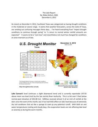
- 1. The Lake Report By: Blake Kellum, SJRA December 6, 2012 As recent as December 4, 2012, Southeast Texas was categorized as having drought conditions in the moderate or severe range. It seems that weather forecasters, across the state of Texas, are sending out confusing messages these days… I’ve heard everything from “expect drought conditions to continue through spring” to “a return to normal winter rainfall amounts are expected.” It seems to be a “coin toss” and nevertheless not much has changed for conditions on area reservoirs as of late. Lake Conroe’s level continues a slight downward trend and is currently reportedat 197.93 above mean sea level (msl) by the San Jacinto River Authority. This is a bit over 3 feet below normal pool elevation of 201.00 msl. SJRAhas received almost ½ of an inch of rainfall at the dam since the start of the month, but it has had little effect on lake level because of extremely dry soil conditions that act like a sponge to soak up any potential runoff. With both air and water temperatures cooling and cloudy days, the evaporation levels are not affecting lake level as severely as during the warm months.
- 2. Lake Livingston, with its massive 17,000 square mile drainage, continues to hold fairly steady at near normal level at ¾ of a foot below. Reported stage, or elevation, at the dam is 130.26msl (normal is 131.00msl). Rainfall in the immediate water shed, since the first of the month, has averaged less than ½ of an inch, but as always, any heavy rainfall event in the upper watershed around the Dallas/Fort Worth Metroplex can impact flows and lake level. The Trinity River Authority is reporting a discharge rate of 1,000 cubic feet per second (cfs) at the dam. These low flows are continued to satisfy the needs of TRA’s downstream customers and stakeholders. For more information on reservoir conditions and much more, go to: www.sjra.net for Lake Conroe and San Jacinto River Authority information orwww.trinityra.org for Lake Livingston and Trinity River Authority information. For information on Lake Levels in all 50 states go to www.lakelevels.info and select the state of your choice from the menu. Data on this site is collected from United States Geological Society (USGS) monitoring stations and may vary somewhat from those reported by the local managing agency. Safe Travels and Merry Christmas to all!