
Recommandé
Contenu connexe
En vedette
En vedette (19)
Dernier
Dernier (20)
Urban design project presentation
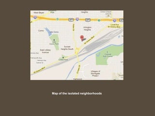
- 1. Map of the isolated neighborhoods Map of the isolated neighborhoods Map of the isolated neighborhoods
- 2. Satellite image of the rail yard. Notice zero access from the north, while the south side has full access (and a Golf Course). The Hulen Street traffic bridge is located in the bottom left corner of the image.
- 3. The Hulen Street traffic bridge. Notice no sidewalks or any pedestrian crossing. The Trinity Trails run directly under the bridge, but there is no access from the north side.
- 4. Photo of the rail yard from the Hulen Street traffic bridge. The affected neighborhoods are to the north, while the Trinity River is to the right.
- 5. The only means of crossing to the river from Vickery Avenue: the tunnel at Rogers Road. This passage is wholly unsafe for foot traffic.
- 6. The Trinity Trail system at University Drive. There are many points of access to the river from this location.
- 7. One of the many public spaces available on the Trinity Trails near University Drive.
- 8. An example of a much smaller scale footbridge extending over a rail yard.
- 9. An example of a smaller pedestrian bridge over a roadway. A bridge similar to this could extend over the intersection of Vickery Avenue and Hulen Street.
- 10. A very nice example of a pedestrian bridge in Berkeley, CA. This bridge is over 300 feet long, and spans one of the busiest freeways in the Bay area.
- 11. Not the message of accessibility the city should offer to its citizens
- 12. Connect these neighborhoods to the rest of the city