SlideShare une entreprise Scribd logo
1  sur  335
Télécharger pour lire hors ligne
161 Acres of Oceanfront property with 6000 feet of
beachfront! This is your opportunity to purchase your
own exclusive private enclave located on Grand Turk
Island in the Turks and Caicos Islands .
Investment opportunity in the Turks and Caicos
 The Turks & Caicos offer a number of advantages for savvy investors:
 English speaking,
 close proximity to the United States,
 direct flights,
 US currency,
 based on English common law,
 stable government,
 NO income, estate, corporate, real estate TAX
 …these are a few reasons the Turks and Caicos are attracting tourists and investors from all over the
world.
 Political Climate:
The Turks and Caicos Islands are officially English speaking with a population close to 30,000 people
made up of both "Belongers" (citizens) and Expatriates. The official currency is the US Dollar.
 Presently, the Turks and Caicos Islands is an internal-governing Overseas Territory with a
ministerial system of government. The country operates from the 2006 constitution which provides
for a Governor appointed by HM the Queen, an Executive Council and a Legislative Council.
 The Governor is responsible for external affairs, defense, internal security, offshore finance and
certain other matters, but is otherwise normally required to act on the advice of the Executive
Council.
 The Executive Council deals with the affairs of the Government. It is presided over by His Excellency
the Governor and is made up of the elected Ministers of Government. The Legislative Council is
responsible for the passage of laws, monitoring Government policies and bringing to account the
Executive Branch on behalf of the electorate.
 Under this structure the Turks and Caicos enjoys a stable government guided by British Law. The
Government is pro-development but is taking a responsible approach by learning from the
experiences of other West Indies neighbors. Tourism is the number one industry with Offshore
Financial services coming in second and growing.
 Investment Climate:
Traditionally the investment opportunities in Turks and Caicos have been based in real estate as
witnessed by the recent high-end condo developments springing up along 12 mile Grace Bay Beach
on Providenciales. As more people become familiar and comfortable with this country as a viable
investment centre, opportunities for offshore investment structures and funds have become
popular.
 Part of this attraction is a well defined regulatory framework within which to operate a
comprehensive range of financial activities including banking, insurance, trusts, mutual funds,
investment dealing, companies and partnerships. TCI's modern legislation is complemented by an
experienced professional infrastructure in the public and private sectors.
 The Turks and Caicos Islands provide a full range of international banking and trust services. There
are many licensed entities that carry out banking business, five licensed to carry out domestic and
international services from within the islands. The Financial Services Commission (FSC) embodies
in a single agency all regulatory aspects of the financial services industry. The FSC is responsible for
licensing and supervising all finance-related operating entities to internationally accepted
standards. The FSC also provides a centralized and cost-effective service for registering companies,
partnerships, trademarks and patents in TCI.
 As well, Investment Dealers legislation was recently introduced which provides for persons to be
licensed as a fund manager, investment adviser or investment dealer.
TCI Exclusive Attractions
 The islands are arranged around the edges of two large limestone plateaus, the Turks Bank, with deep
offshore waters that serve as major transit points for Humpback Whales, spotted Eagle rays, Manta Rays
and Turtles. Anglers who are fishing for Tuna, Wahoo and Blue Marlin use these same rich waters.
Bordering the edges of the islands are lines of coral reef and some of the most impressive walls of coral in
the Caribbean.
In the last decade on Turks and Caicos, divers have begun to discover some of the finest coral reefs and
walls in the world. From the legendary walls of Grand Turk, West Caicos and Provo's Northwest Point to
the historic wrecks south of Salt Cay, a dozen world-class walls have become Mecca for the serious diver.
From late December through April, the entire Atlantic herd of 2,500 Humpback Whales pass through the
shores on their annual migration to the Mouchoir Bank, just 20 - 30 miles southeast. During this period
divers can listen to an underwater concert of the whales' songs. During the summer, divers encounter
Manta Rays cruising the face of the walls. Encounters with Dolphin are not uncommon.
The salt ponds and inland marshes serve as excellent feeding grounds for resident and migratory birds.
Search for Great Blue Herons, Flamingos, Osprey and Pelicans alongside Egrets, Terns, Frigates, Boobies
and other water birds. As part of the National Parks system more than twelve small cays have been set
aside and protected for breeding grounds.
Grand Turk Cruise Center
 The Grand Turk Cruise Center, with direct beachfront access, is a first-class facility
nestled among nearly 14 acres of landscaped grounds. With convenient changing
rooms, showers and lockers for cruise line guests, cruise center visitors also can swim
either in the ocean’s sparkling waters or in one of the largest pools in the Caribbean,
stroll along the idyllic beach, relax in a chaise lounge or covered beach chair, and even
rent a private cabana for the day and enjoy a massage. The cruise center is also home
to a Jimmy Buffet’s Margaritaville, a fun and exciting place the whole family can enjoy.
In the coming year, visitors to the cruise center will have the opportunity to peruse
through a 45,000 sq. ft. shopping center which includes a 10,000 sq. ft. Dufry duty-
free shop, and 35,000 sq. ft. of high end jewelry stores, an array of unique and world-
renowned apparel and t-shirt stores, locally crafted souvenirs and gifts, and food and
beverage facilities.
Scuba Diving/Snorkeling
 The Turks and Caicos Islands are surrounded by one of the most extensive coral reef systems worldwide
(65 miles across and 200 miles long). As a result, the islands are consistently ranked as one of the premier
diving locations in the world.
Excellent visibility (up to 200 feet), pristine reefs, abundant tropical flora and fauna, fish and other
marine life, quality diving services and easy conditions make the Turks and Caicos Islands a world class
diving destination. There is exceptional wall diving starting in shallow turquoise water and dropping off
into the deep blue giving a real thrill. The reef is relatively close to the beach which makes for accessible
beach dives. Shipwrecks, old and new further increase the multiplicity of the islands as an outstanding
diving destination.
A 22 mile-wide channel, the Columbus Passage, separates the Turks Islands from
the Caicos Islands. This 8,000 foot deep passage serves as major transit lines for
migrating, spotted eagle rays, manta rays, turtles and dolphins. Summer waters (82
to 84 degrees Fahrenheit at the surface) are certainly warm enough for swimsuits,
protection in the form of a light wet suit is welcomed by most divers. In the winter,
water temperatures of 74 to 78 degrees Fahrenheit would suggest the use of a 2 to
3mm (1/8 to 3/16 inch) wetsuit. Computers are an advantage owing to the multi-
level nature of diving in the Turks and Caicos.
Grand Turk International Airport
 Grand Turk is our country's capital and its international airport is served by daily flights from
Providenciales/PLS on SkyKing and Air Turks & Caicos. Flying time is approximately 30 minutes. The
airport offers full international entry and departures services, as well as a restaurant/bar, ground
transportation, tourist information, and a full-service FBO for private planes.
Visitors arriving via
international flights and
connecting to Grand Turk
through Providenciales
must first clear immigration
and customs and claim
baggage at PLS before
making the connection to
Grand Turk through the
domestic departure area at
the Provo Airport.
Town
Airport
name ICAO IATA Usage Customs Runway IFR
Rwy
length
Grand
Turk I.
Grand
Turk Intl MBGT GDT Civ. Yes Paved Yes 6300 ft
Hawk’s Nest Plantation
Development Potential
Hawk’s Nest Plantation
Site Data
 Oceanfront Lots: 17 @ +/- 1/3 to ½ acre (9 direct frontage, 8 rear)
 Lagoon Lots: 49 @ +/- 1/3 to ½ acres
 Hilltop Condo/Hotel w/Spa: 5.2 acres -20 units @ 3 bedrooms per
 Oceanfront Condo/Hotel: 8.4 acres – 67 units @ 2 bedrooms per
 Lagoon Condos: 352 Units @ 3 bedrooms per (bldg avg. 4 story)
 Retail: 16,000 S.F. (Potential for maximum 50,000 S.F.)
 Options: Casino Locations
 Sale includes all site plans, environmental studies, hydraulic
studies, engineering studies, and more.
 Price available upon request
For more information contact: William Korff, (843) 224-4221
DRAWING NUMBER
REMARKS
SHEET: OF
Signature
Date
07-1437HawksNestBathymetricSurvey.dwgLayout15/25/07
XrefsAttached=
1485NorthAtlanticAve.,Suite113
CocoaBeach,Florida32931
(321)799-2332
HYDROGRAPHICANDTOPOGRAPHICSURVEY
HAWKESNESTPLANTATION
GRANDTURK,TCI
FORPORTRAITPROPERTIESII,INC.
April2007
07-1437
1"=400'
1 1
GaryW.Bazemore,PSM
CertificateofAuthorization#LB7072
N
”
“ ”
2009
Bill Korff
Hawkes Nest Plantation
1/1/2009
The Competition for Gaming
The following is an excerpt from a 10-K SEC Filing, filed by SYZYGY ENTERTAINMENT LTD on 3/27/2008.
Syzygy Entertainment Ltd, a Nevada corporation, formerly known as Triple Bay Industries, Inc., (“Syzygy” or
“SYZG” or the “Company”), is publicly traded on the Over-The-Counter Bulletin Board market under the ticker
symbol SYZG. Syzygy, through its acquisition of Rounders Ltd., a Turks and Caicos company and The Game
International TCI, Ltd., a Turks and Caicos company (hereinafter collectively referred to as “Rounders”) is focused
on the development and operation of destination gaming and resort facilities in the Turks and Caicos Islands. To
date, Rounders has opened “The Players’ Club”, an up-market licensed casino, bar and slot parlor business on the
growing tourist based island of Providenciales (known as “Provo”). Rounders has opened a second slot parlor on the
island of Grand Turk, the capital of the Turks and Caicos Islands. It is located in Big Daddy’s Beach Shack, adjacent
to the Carnival Cruise Line Facility. Subsequent to year end, Rounders has located 3 additional slot locations on
North Caicos, as well as two additional locations near the airport on Provo. The Company discontinued operations
of the business of manufacturing and selling disposable decontamination systems, which formed the basis of its
operations before the acquisition of Rounders.
Rounders, Ltd., a Turks and Caicos corporation and its affiliated company The Game International TCI, Ltd. (the
“Company” or “Rounders”), were originally incorporated in 2006. Rounders has been placed in a position to work
with a “belonger” (a native islander) associate with the goal of attracting a hotel, casino, gaming and poker room
development to the islands. Rounders together with its partners and affiliated companies has identified an
appropriately sized site located in the Grace Bay resort district that would be suitable for a gaming operation.
Discussions are also underway in regards to the planning, financing, and construction of a destination hotel/gaming
resort.
The Island Opportunity
The Turks & Caicos Islands (TCI) lies at the southern tip of the Bahamas, just 75 minutes by air or 575 miles
Southeast of Miami and covers 193 square miles in the Atlantic Ocean. The Turks and Caicos Islands enjoy
excellent air services from the US, Canada, Europe and the Caribbean, as well as reliable domestic services
throughout the island chain. This accessibility combined with its close location to the US along with the fact that the
Turks and Caicos Islands has the third largest coral reef system in the world, has led to the development of a very
stable, growing, and profitable tourism industry over the last two decades.
4
Initially focusing on the diving industry, the island now encompasses both family beach vacations and increasing
supplies a higher end product that caters to the discerning traveler seeking luxury accommodations. With a
proliferation of upscale boutique resorts along with some of the best tropical beaches in the world, this steady incline
in tourism and increasing accessibility has boosted property development in Turks & Caicos to an unprecedented
scale.
The island currently has two operating casinos with The Players Club being one of them. The Government
recognizes the need to broaden the leisure and entertainment options for the visitor to the island. Casino-style
activities represent an important amenity necessary to enhance Turks & Caicos Islands reputation as a premium
“must visit” destination.
The Players Club
Rounders Ltd opened “The Players’ Club”, an up-market, licensed, casino, bar and slot parlor business on the
growing tourist based island of Providenciales (known as “Provo”) in December of 2006. Provo, while having
visitor numbers in the region of 160,000 tourists a year, does not have a licensed casino operating at this time, and
adult recreational nightlife on island for tourists is limited to bars and restaurants.
Located in the newly opened Queen Angel Resort, a top of the line gaming and poker facility has been completed.
This facility has been outfitted with approximately 80 gaming machines providing 150 player seats, and the
experience of playing games of chance as Texas Hold Em, Black Jack, Roulette, slots and a variety of other card and
dice games. The Players Club provides a gaming experience in the environment of a fully staffed and operational
bar.
Licensing for Live Gaming
On February 8, 2008, we received approval for a full-scale casino license, which is a major addition to our current
offerings. A live gaming license allows us to operate a full scale casino and has shown a dramatic increase in
volume at the current Players’ Club location since introduction. In addition, the live gaming license will allow us to
pursue an international clientele and capture further revenue streams associated with that influx of volume. One of
only two licenses issued in the country, we believe, with our current strategies, we are poised to seize control of the
majority of the gaming dollars in the market.
Licensing for Slot Parlor, 100 Machines for 5 Islands
Rounders has petitioned, and the government has accepted, an application for Rounders to possess a license that
would entitle the Company to have 100 gaming machines on Provo, Grand Turk, North, West, and Middle Caicos.
In the first few months of operation of The Players Club, the Government has recognized the distinct advantages to
facilities like The Players Club, versus games, 4 at a time, located in the bars and restaurants.
5
Grand Turk, a New Facility
In December 2007, Rounders established the first four slot machines in Big Daddy’s Beach Shack, perfectly
positioned next to the Carnival Cruise Line docking station. By partnering with the managers and operators of a
newly opened, first class, Caribbean restaurant, located literally where the Carnival Cruise Ships signature blue
beach chairs conclude, this restaurant property begins. The future development plans for the facility would hold up
to 25 machines and a new building would be constructed to host the remaining machines. Grand Turk is the capital
of the island and hosts most of the government operations and facilities. A mere 3,800 residents call Grand Turk
home, and for the most part, it has been a “sleepy” little island stretching just 14 miles from north to south.
Government officials expect the cruise ship dock to bring an additional 400,000 tourists to the island each year.
Carnival Corp, the parent company of 12 cruise lines, invested $50 million dollars into a cruise ship boat dock, a 13
acre day use resort, featuring the largest Jimmy Buffet Margaritaville themed restaurant in the Caribbean. The newly
opened dock can hold two cruise ships at one time. In addition, Carnival provided start up money to local shore
excursion companies to help support tourist related activities including tour vehicles, horse back rides, snorkeling,
diving, sightseeing, and many other events. Currently, there are approximately 2 cruise ships per week coming into
port, carrying up to 3,400 passengers and 1,800 crew members for the larger ships. At the height of the coming
tourist and cruise season, the Grand Turk port is expected to have one cruise ship per day coming into port.
75 Slot License
Rounders has recently purchased an additional slot route gaming license in the Turks and Caicos that allows for the
deployment of up to 25 gaming machines in a single location. Although the license does not specify which island it
is specifically designated for, management believes it can be used on Provo, Grand Turk, or any other island in the
Turks and Caicos. Rounders intends to develop a lower scale, “locals” facility to utilize this license. By partnering
with an existing building owner, Rounders believes The Players Club, designed more like a traditional gaming
facility, may be too formal for a lot of the local players, which have a more “laid back” Caribbean lifestyle. Local
play on Provo alone was more than six million dollars in 2006 and is growing each year with the growth in tourism
and employment.
Grant of Poker License
Rounders has been granted a one of a kind poker license for the Turks and Caicos. The Government recognized
from the public relations success of the Johnny Chan Invitational, poker can be marketed as an internationally
branded tourist destination event.
The Players Club Turks and Caicos Classic in Association with the World Poker Tour
From September 24, 2007 until October 1, 2007, Rounders hosted a World Poker Tour event on the island called
The Players Club Turks and Caicos Classic. The event was held at Club Med and filmed for the Game Show
Network, scheduled to be aired on May 19, 2008. Local partner, Rhynie Campbell came away with the first place
prize of nearly $433,000. Since the completion of the event, the World Poker Tour has cancelled its agreement with
Rounders, along with most other “foreign location” poker events that they held in 2007.
6
Other Poker Events
In advance of this proposed hotel/gaming resort development that would carry a branded poker room and as an
introduction to poker tournaments on the island, an affiliated event promoter, The Game International Ltd, created
and hosted the Johnny Chan TCI Invitational Poker Tournament, which was held in the Turks & Caicos Islands on
September 9-16, 2006. The field included three World Series of Poker (“ WSOP”) champions, as seen on ESPN,
Carlos “The Matador” Mortenson, Johnny Chan, and the most recent champion, crowned on August 11, 2006, Jamie
Gold. Mr. Gold won a record 12 Million dollars in this years WSOP event. Other pro players included international
names such as David “Devil Fish” Ulliot, Bob “The Butcher” Clark, Jeff Madsen, Bodog player David Williams,
Amir Vahedi, Ian Frazer and a host of local players, with Jac Arama, Ashley Hayes and Michael Greco flying in
from the UK for the Tournament . The eventual winner was the 2001 World Series of Poker champion, Carlos “The
Matador” Mortenson .
In 2007, in an effort to gain a World Poker Tour event, Rounders entered into an agreement with world renowned
poker expert, Jack McClelland. Jack has over twenty-five years experience in poker and is currently the tournament
director and poker room host at the Bellagio Las Vegas. Prior to this, he was at The World Series of Poker with Jack
Binion for fifteen years and the Director for the Commerce Casino in Los Angeles for nine years. Other Las Vegas
tournaments include The Grand Prix of Poker (Golden Nugget), Super Bowl of Poker (Caesars Palace), Queens
Poker Classic (Four Queens) and Knights of the Round Table (Tropicana). Jack is also in the Poker Dealer Hall of
Fame. The agreement with Mr. McClelland has been terminated.
Hotel/Casino, Land and Development
Rounders expects to purchase land that someday will host what would be considered a more traditional, hotel, resort
and gaming facility. Although there are no current agreements, management believes partnering with a “name
brand” hotel operator that would bring a reservation systems and operational management to the island, would be
the best fit possible at this time. The recent approval for a full line class 3 gaming license, which allows live dealing
and a reduced tax rate, adds substantial value to the company and in negotiations with hotel operators and brands.
Other Slot Route Opportunities
Rounders is exploring and evaluating other potential opportunities, both in the United States, Caribbean, Bermuda
and Central America.
7
Employees
At December 31, 2007, the Company’s CEO was the only part-time employee at the Company’s headquarters in
Charlotte, North Carolina. At December 31, 2007, we had 15 full time and 7 part time employees in our gaming
operations in the Turks and Caicos Islands.
Our employees are not represented by a labor union. We have experienced no work stoppage and believe that our
employee relationships are good.
Identification of the Subject Property___________________________
Located on the island of Grand Turk, Hawkes Nest Plantation consists of 161 acres situated on the
Southeast point of the island. The property has approximately 6,000 lineal feet of ocean frontage with
panoramic views of the Atlantic Ocean and the uninhibited islands off the coast. Located adjacent to the
north of the parcel is a newly constructed passenger terminal at the international airport providing a
7000’ runway. This destination is easily accessible from surrounding islands and the main land. Located
adjacent to the west of the property is a new $ 50 Million dual cruise ship port capable of servicing
1,000’ vessels developed by Carnival Cruise Lines.
Natural features on the site consist of beaches, uplands,
varying elevations, 40’bluffs, mangroves, scrub brush and
interior lands. The primary beaches are located off the
southern portion of the property as well as a more private
beach at the northern corner. In between the two sections of
beach are bluffs which rise significantly above the rest of the
property creating 360 degree views of the ocean and site.
Executive Summary__________________________________________
Currently Planned is the Hawkes Nest Plantation Resort, an 865 – unit Five Star Master Planned Resort
Community with a diversified mix of condo Hotel Rooms and Suites, Condominiums, and Single Family
Estate Lots. Resort Amenities include a Casino, an 87-Slip Marina and 35,000 SF Marina Village.
Located on the southwest corner are 17 oceanfront estate style single family lots. The configuration of
lots, commonly referred to as “Flag Lots“, allow each owner their own private access point to the beach.
To the east of the ocean front residences is a parcel dedicated for a high-end Hotel/Casino. With some
of the best beaches this makes for a prime location. Adjacent to this Hotel and east of the main marina
entrance sits a Boutique Hotel with a private yacht club capable of servicing large vessels.
Hawkes Nest Plantation Resort
A Turks and Caicos Island Development
British West Indies
Situated atop the bluffs and overlooking the ocean is another site for an exclusive Hotel with a private
spa. At 5.2 acres the zoning would allow for 124 bedrooms. As this location is situated high above the
resort site, the idea is to create a lower density high-end product. In order to make the product blend in
with the natural topography, and to feel more exclusive, the densities have been reduced by half,
creating sixty seven total units.
On the interior lands of the site there will be canals cut to allow for boat access as well as the creation of
two separate private islands. They will be divided into 47 single family estate home sites. The canals
surrounding these homes vary between 150’ to upwards of 300’ creating a more natural feel to the
waterways. This will allow for larger scale yachts to navigate. The entire perimeter of the estate island
properties will be concrete bulk-heading for direct tie-ups. Average island lot frontage will range from
100’ to 300’.
Surrounding the waterways are condominium units to create a “Marina Village“, look and feel.
Consisting of approximately 244 units at three bedrooms per unit the buildings will vary in height from
four to six stories to create architectural interests. The frontage of the condominiums will also be
entirely bulk-headed allowing for each residence to have a slip in front of their units.
Located at the main entrance to the site will be a retail marina village with shops, a convenience market,
dining, shopping, etc. and a public plaza. The space will offer services and amenities for both residents of
the site as well as potential passengers and other tourists. By the nature of its location, the retail village
will serve to capture visitors close to the entrance of the property as well as yachting transits and keep
the remaining properties exclusive.
The mixed-use Properties mentioned above as well as the Retail and Commercial outfits provide an
array of residual income streams in addition to the Real Estate Build-out. These income streams will
span Land and Square Footage Leases, Property Management, Marina Operations, Wastewater
Collection, Utilities, Telecommunications and Excursions. Government incentives are No Property Tax,
No Income Tax, No Capital Gains Tax, Utility Licensing, Offshore Banking and other local Business
incentives.
Company Profile
The property was acquired in August, 2004’. Since then the company has engaged in assembling a
master planning team for the development of the plantation. Several work shops have been conducted
to decide the best mixed use for the parcel along with many studies that illustrate the marina function
and how it relates to the environment. To date, the conceptual Master Planning is complete as well as
the program design for the Marina Basin. In addition, all Utility Infrastructure and design analysis for the
parcel has been completed. A Mangrove Assessment is complete with key findings that support the
design program. A Marine Baseline Assessment along with a Hydro-Flushing Analysis was also conducted
and added to our master plan. Several feasibility studies have been performed over the years as the
master plan was shaped into its current configuration.
Development Team________________________________________
Master Planners EDSA Edsaplan.com
Marine Engineers ATM Appliedtm.com
Leisure Consultants Norton NortonConsulting.net
Civil Engineers CSE Cse@tciway.tc
General Contractors Johnston Int. Johnstonint.com
Legal Team Miller, Simmons, O’Sullivan Mslaw@tciway.tc
Project Impact_____________________________________________
The project proposed will create more than 750 new employment positions ranging from Hotel Staff,
Casino Operators, Restaurant Staff, Retail Boutique Shops, Management Agents, Hospitality Staff,
Marina Operations, Private Services, Tourism Services, Sport Fishing, Real Estate Sales and Service,
Resort Operations and Upper Management. This will have a tremendous positive impact for the Local
Government as well as the Local Island residence. These jobs will allow local residence to mitigate their
travel to other outer islands for employment which in turn will gain their support for overall
development. The Economic impact for the Local Government will be welcome by the Ministry as well as
the Residents in conjunction with creating a sustainable project for growth and employment.
Resort Project and the Environment__________________________
The development team has made a very strong effort to fully understand the current project proposed
including the Specific Site and its Surrounding Environments. To date we have conducted the following
studies that formed the basis of our Master Planned Development:
A) Site Survey
B) Topography Survey
C) Site Reconnaissance
D) Marine Benthic Survey
E) Hydrology Flushing Analysis
F) Mangrove Assessment
G) Coastal Impact Assessment
H) Marine Market Overview
I) Wind & Hazard Study
J) Feasibility Study
K) Utility Infrastructure Design
Support materials and individual studies, analysis, assessments and reports available upon request.
Inquiries___________________________________________________
Please send your contact information to Bkorffpti@cs.com and reference Hawkes Nest Plantation
Resort.
BASELINE MANGROVE ASSESSMENT
HAWKES NEST PROJECT SITE
GRAND TURK
TURKS & CAICOS ISLANDS
APPLIED TECHNOLOGY AND MANAGEMENT, INC.
2770 NW 43 STREET, SUITE B
GAINESVILLE, FL, 32606
352-375-8700
1.0 INTRODUCTION
A baseline assessment of a mangrove wetland on the Hawkes Nest project site on
Grand Turk was conducted April 10 through 12, 2007. The mangrove wetland includes
approximately 37 acres and is located on the south side of South Creek, just off the
eastern end of the runway for the Grand Turk airport. ATM personnel conducting the
assessment were John Bossart and Dan Rich. John Waszak surveyed spot elevations.
The purpose for the baseline assessment was to determine existing site conditions for
subsequent use in master planning and impact analysis.
Overall, the mangroves are healthy and of high quality, consisting of an intertidal zone of
fringing red mangrove (Rhizophora mangle) and a basin mangrove forest with mixed red
and black (Avicennia germinans) mangroves. The mangroves were associated with a
shallow salt pond and intermittent patches of herbaceous high-marsh and salt barrens.
Red and black mangrove trees are in excess of 30 feet tall within the basin forest, and
black mangroves were measured with trunk diameters up to 30 inches. The basin forest
is a prolific breeding ground for salt marsh mosquitoes; however, opportunities exist to
combine mosquito control with recreational kayak trails.
1
2.0 MANGROVE MAPPING
Mapping of the different plant communities within the mangrove wetland was conducted
using an infrared satellite image dated 25 March 2003. Figure 1 provides a map
delineating the different wetland components that were identified. Mapping units are
described in the following sections.
2.1 RM (RED MANGROVE)
The site includes both intertidal and non-tidal red mangrove stands. All intertidal red
mangrove is located along the South Creek shoreline, where it occurs in a dense,
monotypic stand with its characteristic tangled mass of prop roots. Red mangrove tree
heights within the fringing forest are generally 10 to 15 feet; however, some trees near
the western end of the fringe (near the airport) are more than 30 feet tall. Several other
monotypic stands of red mangrove occur in the non-tidal, basin zone of the mangrove
wetland. Tree heights in these areas were approximately 10 to 15 feet.
Photo 1. Intertidal red mangrove fringe along South Creek. Turtle grass (Thalassia
testudinum) is growing on the bottom among the roots.
2
3
2.2 BM – SHRUBBY (BLACK MANGROVE, SHRUB-SIZED)
Shrub-sized black mangroves are located north of the large salt pond. These
mangroves were generally no more than 6 to 8 feet in height. The individual shrubs
were scattered in distribution with open ground between them.
Photo 2. Shrubby black mangroves to north of salt pond
2.3 RM/BM – TALL (MIXED RED AND BLACK MANGROVE, WITH RM
DOMINANT, HEIGHT TO 30+ FEET)
This mapping unit was identified within a single stand at the south end of the basin zone.
This area is densely vegetated with both red and black mangroves, with the red
mangrove dominating. Tree heights were in excess of 30 feet. Black mangroves were
generally larger than the red mangroves, with some of the black mangroves having trunk
diameters up to 30 inches.
4
Photo 3. Red mangrove prop roots within the mixed red and black mangrove stand. Survey
rod height is 8 feet.
2.4 BM/RM – TALL (MIXED BLACK AND RED MANGROVE, WITH BM
DOMINANT, HEIGHT TO 30+ FEET)
This mapping unit was similar in structure to the RM/BM – Tall mapping unit, however, in
this case, the black mangroves outnumbered the red mangroves. Tree heights were
more than 30 feet, but the understory was much more open than in the areas dominated
by red mangrove because there were fewer red mangrove prop roots.
5
Photo 4. Black mangrove dominated portion of mixed red and black mangrove stand. Pencil-
like structures are black mangrove pneumatophores, which are part of the black
mangrove’s root system and provide aeration to the underlying roots that are buried
in the saturated, anoxic mud.
2.5 HIGH MARSH
High marsh is a common wetland component around mangrove-dominated areas and is
characterized by low-growing, herbaceous vegetation. At Hawkes Nest, the
herbaceous, high marsh vegetation is dominated by saltgrass (Distichlis spicata),
saltwort (Batis maritima), glasswort (Salicornia spp.), and sea purslane (Sesuvium
portulacastrum). High marsh is inundated infrequently, such as during spring tides or
weather-driven high water events. Excessive evaporation maintains a very high soil
salinity.
2.6 SALT POND
The Hawkes Nest site includes a shallow salt pond typical of the Bahamas archipelago.
The water depth was very shallow during the field survey, so birds could wade at
generally any location within the pond. However, the water level probably rises in
6
response to rainfall. As is typical with these types of salt ponds, during periods of low
rainfall, the pond water probably evaporates completely, leaving an exposed mud flat
that would be favored by foraging shorebirds. Pond water salinity in these types of
ponds is highly variable in response to rainfall and evaporation. The pond water salinity
on the day of the site survey was 35 ppt, which is the same as ocean water. Pond water
salinity can fall to nearly zero in response to heavy rains. As the water evaporates, the
remaining water becomes increasingly saline. Salinities well in excess of 100 ppt are
common in salt ponds, which is a primary reason their bottoms remain unvegetated.
Photo 5. View to the north from southeast corner of salt pond at Hawkes Nest site. The birds
near the black mangrove are two white-cheeked pintail ducks and a black-necked
stilt.
7
Photo 6. View to the southeast from west shoreline of salt pond at Hawkes Nest project site.
2.7 SALT BARREN
Like high marsh, salt barrens are commonly found in mangrove systems. Salt barrens
are unvegetated, or sparsely vegetated, areas of highly saline sands. The sparse
vegetation that does grow consists of the same species as found in the high marsh, i.e.,
saltgrass (Distichlis spicata), saltwort (Batis maritima), glasswort (Salicornia spp.), and
sea purslane (Sesuvium portulacastrum).
8
3.0 TIDE RANGE IN RELATION TO MANGROVE ELEVATIONS
Zonation of red and black mangroves is largely determined by their location in relation to
the tide range. Red mangroves typically occur at lower elevations (mean high water and
below), so they are tidally inundated more frequently and to a deeper depth than black
mangroves, which occur at elevations at or above mean high water. Fringing mangrove
systems are directly connected to the tidal waters. Basin mangrove systems are at least
partially isolated from the tide, usually by a low-relief ridge that is only crested by higher
tides, such as spring tides.
Tidal datums were measured using a tide gauge set in South Creek. The gauge was in
place for 41 days from February 28 through April 10, 2007. Summary statistics for
standard tide parameters are provided in Table 1.
Table 1. Summary Statistics for Tide Data Collected in South Creek
MAX 2.12 feet
MHHW 1.54
MHW 1.32
MTL 0.42
MLW -0.46
MLLW -0.57
MIN -0.95
The tide range between MHW and MLW is 1.78 feet, with a total mean tide range of 2.11
feet. The range between maximum and minimum water elevations is 3.07 feet. Figure 2
provides a stage-duration curve for the tide data.
Spot elevations at selected locations within the mangroves were measured using an
RTK GPS. A number of spot elevations of the submerged bottom of South Creek were
measured along the waterward edge of the fringing mangrove system, right along the
tree drip line. Bottom elevations along the mangrove fringe ranged from -0.6 to -1.6 feet,
with an average elevation of -1.17 feet. Based on the measured tides, water depths
along the waterward edge of the fringing mangrove system are 2.49 feet during a mean
high water event (MHW = +1.32 feet) and up to 2.71 feet during a mean higher high
water event (MHHW = +1.54 feet).
9
The elevation of the submerged bottom along the mangrove fringe is indicated on the
stage-duration curve (Figure 2). Even during the lowest of low tides (-0.95 foot), there is
still an average depth of 0.22 foot along the waterward edge of the mangrove fringe.
Average water depths are 0.71 foot during mean low tide events. This means that the
mangrove prop roots along the waterward edge are always submerged and can support
the growth of epiphytic algae and invertebrates, and provide protective habitat for
juvenile fish.
In contrast to the mangrove fringe, spot elevations measured within the shrubby black
mangroves within the basin zone ranged from +1.2 to +1.6 feet, which is generally at or
above mean high water (Figure 2). Tidal inundation through the basin zone is
intermittent, at best occurring only during spring tide or other high tide events. The
majority of the time the ground in the basin mangrove zone is exposed. Red mangrove
prop roots, as well as all the other plant stems in the basin zone, do not show water lines
or colonization by epiphytic algae or invertebrates.
-2.5
-2
-1.5
-1
-0.5
0
0.5
1
1.5
2
2.5
0 10 20 30 40 50 60 70 80 90 10
Duration
TideStage(ft)
0
Ground elevation in shrubby black mangrove
Submerged bottom elevation along mangrove fringe
MHW
Mean Tide
MLW
Figure 2. Stage-Duration Curve for Tide Data Collected in South Creek 28 February
through 10 April 2007.
10
4.0 RECOMMENDATIONS
Development at the Hawkes Nest project site will largely surround the existing mangrove
wetland, including excavation of a marina basin in adjacent uplands to the west and
excavation of a flushing channel across the mangrove fringe along South Creek.
However, the mangrove wetland is a prolific source of salt marsh mosquitoes, which
must be brought under control to accommodate the surrounding development. A series
of flushing channels would open the area to tidal inundation and serve to reduce
mosquito breeding areas at the source. If appropriately designed and constructed, these
tidal channels may also be used as kayak trails and become a valuable ecotourism
amenity. Finally, these tidal channels may also provide the opportunity to accrue
mitigation credit for use in offsetting impacts in cutting the flushing channel through the
mangrove fringe, as well as the nearshore waters. A recommendation for combining
mosquito control flushing with kayak trails is provided below, as well as a discussion
regarding potential mitigation credit.
The mangrove wetland provides the conditions to breed enormous numbers of salt
marsh mosquitoes. Unlike fresh water mosquitoes that lay eggs in containers of
stagnant water (old tires, flower pots, and roadside ditches being common examples),
salt marsh mosquitoes lay their eggs on damp mud, such as that found within black
mangrove forests and high marshes. The female salt marsh mosquito is adept at
locating the micro-depressions in the wetland surface that will fill with water and remain
flooded after rain or an unusually high tide (e.g., a spring tide). After the female
mosquito deposits her eggs on the damp mud within the mangroves, the eggs lie
dormant until a flooding event occurs, at which time the eggs hatch and the cycle
repeats.
Mosquito source control depends on removing the opportunities for mosquito eggs to lie
dormant. Flushing channels that expose egg-laying sites to tidal inundation directly
remove the eggs and also allow access for small fish to prey on both eggs and mosquito
larvae. Figure 3 provides a conceptual plan for a series of tidal flushing channels
through the mangroves. The goal of the flushing channels is to convert much of the
basin mangrove to an intertidal system. The main channels are intended to be
augmented by much smaller secondary channels that would specifically target mosquito
11
12
breeding sites that are identified by comprehensive field reconnaissance by mosquito
control specialists.
Figure 4 provides a conceptual cross-section illustrating potential design components for
the main tidal channels. The main tidal channels will have variable widths, anticipated to
be between 15 and 30 feet. Channels will be excavated to a depth sufficient to maintain
at least a 2-foot water depth even at lower low tide. This will facilitate fish movement
and provide for kayak access. The main channels will be lined with red mangroves
planted along variable-width planting areas. During rising tides, water will overtop the
channel banks and flood the adjacent red mangrove planting zones. During a falling
tide, water will drain from the mangrove planting areas and, at low tide, will be confined
within the tidal channels. The planted ground elevations within the mangrove zones will
be intermediate between high and low tides. The channels and mangrove planting areas
will be excavated out of the underlying limestone. Planting areas will be overexcavated
by a minimum of 4 feet and then backfilled with sand overlain by muck. A rock sill
between the channels and the planting areas will retain the sand and muck and prevent
it from being washed into the channel during falling tides.
Only red mangroves will be planted in the restoration areas. Red mangroves are the
best adapted to deep tidal inundation, and their dense, tangled prop roots provide the
most valuable marine nursery habitat and contribute the most to marine fisheries. If
planted properly, the red mangroves will grow up and over the channels, forming a
tunnel effect that will add to the aesthetics while kayaking (Photo 7). Boardwalks and
observation platforms can also be incorporated into the concept.
Photo 7. Example of a kayak trail overtopped by red mangroves.
13
14
Wildlife habitat diversity within the mangrove restoration areas can also be increased by
incorporating a number of small, open ponds. These ponds would be randomly located
within the mangrove planting areas and have variable shapes, widths, and depths. Like
the tidal channels, these ponds will be excavated from the rock substrate, but not
backfilled with sand and muck. However, the ponds will not be connected to the tidal
channel network so they will hold water during low tide, allowing them to serve as refugia
for fish. During high tides, when the mangrove prop roots are flooded, the fish will
migrate from their low tide refugia and forage among the prop roots. In addition, the
outer pond edges will include shallow, variable-width littoral zones to provide foraging
areas for shorebirds and wading birds. Littoral shelves can be included along some
secondary tidal channel edges. The primary contribution of red mangroves to marine
productivity is the intertidal nursery habitat provided by their prop roots. For the Hawkes
Nest mangroves, this contribution to marine productivity is limited to the red mangrove
fringe along South Creek. The submerged prop roots of these mangroves are richly
colonized by epiphytic algae and invertebrates, which provide a food source for juvenile
fish. The tangle maze of submerged prop roots also provides cover for the juvenile fish.
In contrast, mangroves within the basin zone are not regularly inundated by tides and do
not directly contribute to marine productivity. Because these mangroves are isolated
from a direct connection to tidal inundation, they do not provide any habitat for juvenile
fish. Despite the presence of red mangroves within the basin zone, their prop roots are
rarely submerged and, therefore, do not support any colonization by epiphytic algae or
invertebrates.
By maximizing the area that is completely flooded during every high tide, small fish will
have maximum access to all areas and will be able to prey on mosquito eggs and larvae.
However, not all of the existing basin mangrove can or should be converted to intertidal
mangrove, and additional mosquito control options will have to be employed. These
options include the installation of smaller, secondary tidal channels that will allow fish
access to isolated sites, the application of mosquito larvae pathogens to defined
breeding trouble spots, and the use of mosquito traps.
The smaller, secondary channels would not be intended for kayak use but would be
routed to specifically target mosquito-breeding sites. Such sites would be identified by
15
comprehensive reconnaissance of the entire mangrove site. While extensive excavation
and grading will be necessary to install the main channels, red mangrove planting areas,
and any additional ponds that may be incorporated, the secondary channels can be
installed with a rotary ditcher. This unit is typically pulled behind a tractor fitted with
oversized, low-pressure tires that will support the tractor on the soft wetland surface.
The rotary ditcher simultaneously cuts a small ditch and side casts the excavated
material as a fine film of mud. Determining the feasibility of this construction method will
require consideration of the depth to the underlying limestone.
Mosquito breeding sites within the mangroves that remain outside the reach of tidal
inundation may also be controlled by mosquito larvae pathogens that are added to
known breeding sites after rains or high tide events. These pathogens are a freeze-
dried bacteria, Bacillus thuringensis israeliensis, or BTI, that is marketed as a
compressed briquette. These briquettes are thrown into the standing water where the
mosquitoes are known to breed. The water reconstitutes the dried bacteria, which then
attack and kill the mosquito larvae. The BTI has the advantage of being very target
specific, unlike a general insecticide.
For mosquitoes that escape the source control measures, CO2 generating mosquito
traps have been shown to very effective elsewhere in the Turks and Caicos, specifically
Parrot Cay. These traps use bottled propane to produce CO2, which attracts mosquitoes
and funnels them into a trap, where they are removed from the breeding population.
Continual operation of the traps causes the local mosquito population to crash after
several weeks and continued operation prevents the breeding population from becoming
reestablished.
A formal mosquito management plan may be an appropriate consideration for the overall
resort planning. Dr. David Dame, a retired University of Florida entomologist and former
president of the American Mosquito Control Association is a recommended consultant.
He travels worldwide consulting on mosquito control issues for projects such as Hawkes
Nest.
16
Hydrodynamic and Flushing
Analysis
Proposed Marina at Hawkes Nest Plantation,
GrandTurk, BWI
PREPARED BY:
APPLIED TECHNOLOGY AND MANAGEMENT, INC.
CHARLESTON, SC
USA
PREPARED FOR:
MR. JOHN SKERCHEK, PORTRAIT PROPERTIES II, INC.
MAY 2007
II
Table of Contents
1. INTRODUCTION.......................................................................................................................................................1
1.1. SITE LOCATION AND DESCRIPTION ...........................................................................................................1
1.2. REPORT OUTLINE.......................................................................................................................................1
2. MODEL DESCRIPTION ..........................................................................................................................................4
3. MODEL SET-UP.........................................................................................................................................................6
3.1. MODEL GEOMETRY ...................................................................................................................................6
3.2. BATHYMETRY ............................................................................................................................................6
3.3. TIDAL FORCING..........................................................................................................................................6
3.4. WIND ..........................................................................................................................................................7
4. MODEL RESULTS ..................................................................................................................................................13
4.1. HYDRODYNAMIC MODEL RESULTS ........................................................................................................13
4.2. FLUSHING MODEL RESULTS....................................................................................................................13
5. CONCLUSIONS AND RECOMMENDATIONS...............................................................................................18
REFERENCES .....................................................................................................................................................................19
III
List of Figures
FIGURE 1-1 LOCATION MAP OF PROPOSED MARINA AT HAWKES NEST PLANTATION, GRAND TURK, BWI................................2
FIGURE 1-2 SKETCH OF PROPOSED MARINA LAYOUT. ....................................................................................................................3
FIGURE 3-1 MODEL GRID OF THE PROPOSED MARINA – SCENARIO 1.............................................................................................9
FIGURE 3-2 MODEL GRID OF THE PROPOSED MARINA – SCENARIOS 2 AND 3..............................................................................10
FIGURE 3-3 MODEL GRID DEPTHS..................................................................................................................................................11
FIGURE 3-4 MEASURED WATER SURFACE ELEVATIONS AT PROJECT SITE....................................................................................12
FIGURE 4-1 SIMULATED CURRENT MAGNITUDES DURING PEAK FLOOD CONDITION...................................................................15
FIGURE 4-2 SIMULATED CURRENT MAGNITUDES DURING PEAK EBB CONDITION........................................................................16
FIGURE 4-3 SIMULATED DYE CONCENTRATION IN MARINA BASIN VERSUS TIME........................................................................17
IV
List of Tables
TABLE 3-1WIND DATA, GRAND TURK ISLAND..............................................................................................................................8
TABLE 4-1 PREDICTED FLUSHING TIMES FOR THE PROPOSED MARINA BASIN AND FLUSHING OPTIONS. ....................................14
1
Hydrodynamic and Flushing Analysis
Proposed Marina at Hawkes Nest Plantation, Grand Turk, BWI
1. INTRODUCTION
This hydrodynamic and flushing analysis was completed to address circulation and flushing
concerns for the proposed marina development at Hawkes Nest Plantation, Grand Turk,
GWI. Adequate flushing reduces the potential for the stagnation of water in the marina basin,
helps to maintain the biological productivity, and reduces the potential for toxic accumulation
in bottom sediment. Maintaining water quality within a basin depends primarily on flushing as
determined by water circulation within the basin, and minimizing sources of pollution in the
basin.
This study utilized a numerical model to simulate the flushing of conservative pollutants in the
proposed marina system over time. The results of the simulations were used to determine if
the basin exhibits good circulation and flushing characteristics.
1.1. Site Location and Description
Hawkes Nest Plantation is located near the southern end of Grand Turk Island, Turks
and Caicos Island, BWI, as shown in Figure 1-1. The layout of the proposed marina is
shown in Figure 1-2. The new marina basin will be excavated to depths of 11 ft below Mean
Low Water (MLW). Two flushing and entrance channels, with depths of 5 ft and 12 ft (MLW),
respectively, connect the marina basin to the open water.
1.2. Report Outline
This report presents the model study in the following sections:
• Section 2 presents a detailed description of the model used for the flushing study;
• Section 3 presents the model set-up and describes the data input to the model;
• Section 4 presents the hydrodynamic and flushing model results; and
• Section 5 provides the report conclusions.
Figure 1-1
Location map of proposed marina at Hawkes Nest Plantation,
Grand Turk, BWI.
Project site
Figure 1-2
Sketch of proposed marina layout.
4
2. MODEL DESCRIPTION
The Environmental Fluid Dynamics Code (EFDC) was used for this project. EFDC is a
general purpose modeling package for simulating two or three-dimensional flow, transport
and biogeochemical process in surface water systems including: rivers, lakes, estuaries,
reservoirs, wetlands and near shore to shelf scale coastal regions. The EFDC model was
originally developed at the Virginia Institute of Marine Science for estuarine and coastal
applications and is considered public domain software.
In addition to hydrodynamic, salinity, and temperature transport simulation capabilities, EFDC
is capable of simulating cohesive and noncohesive sediment transport, near field and far field
discharge dilution from multiple sources, eutrophication processes, the transport and fate of
toxic contaminants in the water and sediment phases, and the transport and fate of various
finfish and shellfish. Special enhancements to the hydrodynamic portion of the code,
including: vegetation resistance, drying and wetting, hydraulic structure representation, wave-
current boundary layer interaction and wave induced currents, allowing refined modeling of
wetland and marsh systems, controlled flow systems, and nearshore wave induced currents
and sediment transport.
The following description is from the introduction to the EFDC User Manual (Hamrick, 1996):
The physics of the EFDC model, and many aspects of the
computational scheme, are equivalent to the widely used Blumberg-
Mellor model (Blumberg and Mellor, 1987) and the U.S. Army Corps
of Engineers’ CH3D or Chesapeake Bay model (Johnson, et al,
1993). The EFDC model solves the three-dimensional, vertically
hydrostatic, free surface, turbulent averaged equations of motions
for a variable density fluid. Dynamically coupled transport equations
for turbulent kinetic energy, turbulent length scale, salinity and
temperature are also solved. The two turbulence parameter
transport equations implement the Mellor-Yamda level 2.5
turbulence closure scheme (Mellor and Yamada, 1982; Galperin et
al, 1988). The EFDC model uses a stretched or sigma vertical
coordinate and Cartesian or curvilinear, orthogonal horizontal
coordinates.
The numerical scheme employed in EFDC to solve the equations of
motion uses second order accurate spatial finite differencing on a
staggered or C grid. The model’s time integration employs a second
order accurate three-time level, finite difference scheme with an
internal-external mode splitting procedure to separate the internal
shear or baroclinic mode from the external free surface gravity wave
or barotropic mode. The external mode solution is semi-implicit, and
simultaneously computes the two-dimensional surface elevation
field by a preconditioned conjugate gradient procedure. The
external solution is completed by the calculation of the depth
average barotropic velocities using the new surface elevation field.
The model’s semi-implicit external solution allows large time steps
that are constrained only by the stability criteria of the explicit central
difference or high order upwind advection scheme (Smolarkiewicz
and Margolin, 1993) used for the nonlinear accelerations. Horizontal
5
boundary conditions for the external mode solution include potions
for simultaneously specifying the surface elevation only, the
characteristic of an incoming wave (Bennett and McIntosh, 1982),
free radiation of an outgoing wave (Bennett, 1976) or the normal
volumetric flux on arbitrary portions of the boundary. The EFDC
model’s internal momentum equation solution, at the same time
step as the external, is implicit with respect to vertical diffusion. The
internal solution of the momentum equations is in terms of the
vertical profile of shear stress and velocity shear, which results in
the simplest and most accurate form of the baroclinic pressure
gradients and eliminates the over-determined character of alternate
internal mode formulations. Time splitting inherent in the three time
level scheme is controlled by periodic insertion of a second order
accurate two time level trapezoidal step. The EFDC model is also
readily configured as a two-dimensional mode in either the
horizontal or vertical planes.
The EFDC model implements a second order accurate in space
and time, mass conservation fractional step solution scheme for the
Eulerian transport equations for salinity, temperature, suspended
sediment, water quality constituents and toxic contaminants. The
transport equations are temporally integrated at the same time step
or twice the time step of the momentum equation solution
(Smolarkiewicz and Margolin, 1993). The advective step of the
transport solution uses either the central difference scheme used in
the Blumberg-Mellor model or a hierarchy of positive definite upwind
difference schemes. The highest accuracy upwind scheme, second
order accurate in space and time, is base on a flux corrected
transport version of Smolarkiewicz’s multidimensional positive
definite advection transport algorithm numerical diffusion. The
horizontal diffusion step, if required, is explicit in time, while the
vertical diffusion step is implicit. Horizontal boundary conditions
include time variable material inflow concentrations, upwinded
outflow, and a damping relation specification of climatological
boundary concentration. For the temperature transport equation, the
NOAA Geophysical Fluid Dynamics Laboratory’s atmospheric heat
exchange model (Rosati and Miyakoda, 1988) is implemented.
6
3. MODEL SET-UP
The model set-up requires the user to build a model grid based on the geometry of the study
area (i.e., the shorelines and bathymetry) and develop the model inputs (i.e., the boundary
forcings and model coefficients). The boundary forcings used for this study include the
offshore tidal elevations and wind.
In support of the model application, ATM conducted field investigations in the vicinity of the
proposed project from February 28 to April 10, 2005. The purpose of the data collection was
to characterize the depths at the project site and measure the tidal signals near the project
site.
3.1. Model Geometry
The model geometry is defined by the shorelines of Grand Turk Island and the proposed
marina basin. The marina basin boundaries were digitized and imported from a TIF drawing
file created by Portrait Properties II, LLC. After the marina basin was merged with the island
shoreline, the shoreline was translated to local grid coordinates based on the coordinates of
marina basin. The shorelines were then transformed into a GIS basemap and used as a
guide for development of the numerical model grid.
Three scenarios with different locations of flushing and entrance channels were simulated in
this study. In these three scenarios, the entrance channel is 200 ft wide and 12 ft deep
relative to Mean Low Water (MLW), and the flushing channel is 100 ft wide and 5 ft deep
relative to MLW. Their computational grids are presented in Figures 3-1 and 3-2. The model
grid covers the entire marina basin and two entrance and flushing channels. The grid cells
range in size from 15 meters wide in the flushing and entrance channels to 10 meters wide in
the marina basin and 200 meters in the area away from the project site. The higher resolution
in the project area was desired in order to accurately simulate the current pattern in the
project site. The furthest north and west cells at the seaside are considered as the boundary
cells in the model.
3.2. Bathymetry
Local bathymetry was input to the model grid by using the GIS editor to select grid cells and
specify the grid cell depth. March 1, 2007 survey data collected by ATM in the study area
were used to define the model grid depths in the nearshore areas. The bathymetry in the
marina basin and entrance and flushing channels was based on the proposed dredge depth
of 11 ft (3.3 m), 12 ft (3.6 m) and 5 ft (1.5 m) relative to MLW. The model grid depths are
shown in Figure 3-3.
3.3. Tidal Forcing
Water surface elevations in the model were forced at the north and south ocean boundaries.
Tidal measurements were collected at the project site between February 28 and April 10,
2007. Figure 3-4 shows the tidal records measured at this location. Local tides are semi-
diurnal (i.e., two high tides and two low tides per day), with an inequality between successive
highs and lows. The US Army Corps of Engineers ADCIRC model simulated tidal database
for the western Atlantic basin was used to evaluate tidal phasing in the vicinity of Grand Turk
7
Island. Based on this analysis, it was determined that it is reasonable to assume that there is
no tidal phase difference between the model boundaries.
3.4. Wind
Wind data is available for Grand Turk Island, based on hourly surface wind observations
between November 1954 and November 1968 made by the United States Air Force. The
values of mean wind speed and percent occurrence of wind are greatest from due east (i.e.,
trade winds). Of significant importance is the 90-degree sector between northeast and
southeast, which accounts for 89% of the average annual wind energy. These data, along
with the local shoreline orientation and nearby sheltering features indicate that the prevailing
winds at the project site would blow along the channel from the east. Table 3-1 provides
wind data from Grand Turk.
The 6.7m/s wind condition is exceeded 89 percent of the time, and therefore can be used to
represent a minimum wind condition. Therefore, a steady minimum average wind of 6.7m/s
from the east was used in this study.
8
Table 3-1 Wind data, Grand Turk Island.
Figure 3-1
Model grid of the proposed marina – Scenario 1.
Flushing Channel
Entrance Channel
Figure 3-2
Model grid of the proposed marina – Scenarios 2 and 3.
Flushing Channel
Entrance Channel
Entrance Channel
Flushing Channel
Figure 3-3
Model grid depths for Scenario 1 (shown as meters below
MLW).
Figure 3-4
Measured water surface elevations at project site.
-1.00
-0.80
-0.60
-0.40
-0.20
0.00
0.20
0.40
0.60
0.80
1.00
2/28/07 3/5/07 3/10/07 3/15/07 3/20/07 3/25/07 3/30/07 4/4/07 4/9/07
Day
WaterSurfaceElevation(m)
13
4. MODEL RESULTS
4.1. Hydrodynamic Model Results
The hydrodynamic model was used to simulate the flow of water in and out of the marina
basin over a period of ten days for the three scenarios discussed in Section 3.1 (grids shown
in Figures 3-1 and 3-2). The tides used for the model simulation are shown in Figure 3-3. The
model simulation started with the neap portion of the tidal cycle. This results in a somewhat
conservative analysis, since the larger range of spring tide conditions would result in
increased tidal flows and flushing.
Scenario 3 generated the largest currents in the basin, as compared to the other two
scenarios. In general, currents during neap tides are smaller than during spring tides, which is
due to higher tidal ranges associated with spring tides. Simulated current magnitudes for
Scenario 3 during peak flood and peak ebb for spring tide are shown in Figures 4-1 and 4-2.
The results indicate that the currents in the basin will be much smaller than in the channels.
The maximum speeds are 0.12 m/s in the north entrance channel, 0.04 m/s in the south
flushing channel, and 0.04 m/s or less in the basin.
4.2. Flushing Model Results
The U.S. Environmental Protection Agency (USEPA) recommends that in order to provide
reasonable assurance that water quality will not be a concern, flushing times should not
exceed four days (USEPA, 1985). However, it should be noted that flushing times in excess
of four days do not necessarily indicate poor water quality or that applicable water quality
standards will be violated. Clark (1983) recommends that a maximum time of 2-4 days should
be safe as a design criterion while a period of more than 10 days should be considered an
unacceptable flushing time. The generally accepted concentration target for these flushing
times, based on the concentration of a conservative tracer (as utilized herein), is 10 percent
of initial loading.
For this study, the entire marina basin was assumed to have an initial concentration of 100
percent (i.e., a unit concentration of 1). 10 percent tracer remaining after four days or less will
be considered good flushing, 10 percent remaining after 4 to 10 days will be considered
marginal flushing, and greater than 10 days will be considered unacceptable flushing.
The overall dye concentration in the entire basin under steady easterly wind condition at
different time is summarized in a plot of the relative initial pollutant mass remaining in the
marina basin versus time (Figure 4-3).
For Scenario 1, the proposed marina basin will flush to 58.1% of the initial dye remaining after
4 days and 38.2% remaining after 10 days, which is considered a poor flushing rate.
For Scenario 2, the proposed basin will flush to 10% of the initial dye remaining within 2.9
days, which is considered a good flushing rate.
14
For Scenario 3, the results show that the initial dye concentration in the proposed marina
basin will disperses quickly and will flush to 10% remain only within 1.2 days. Furthermore, it
will flush to 0.3% remaining after 4 days. It is considered a very good flushing rate.
Overall, the study results indicate that proposed marina basin will flush very quickly if the
entrance and flushing channels are designed at the right location. Therefore, the basin will
exhibit good water quality and clarity as long as best management practices (BMPs) are
employed to minimize pollution sources to the basin.
Table 4-1 Predicted flushing times for the proposed marina basin and flushing options.
Flushing Options
Scenario Entrance
channel
Flushing
channel
Percent Initial
Concentration
after 4 days
Time Required
to Reach 10%
Initial
Concentration
1 At north In the middle 58.1% > 10 days
2 At north At south 3.1% 2.9 days
3 At south At north 0.3% 1.2 days
Figure 4-1
Simulated current magnitude during peak flood conditions.
Figure 4-2
Simulated current magnitude during peak ebb conditions.
Figure 4-3
Simulated dye concentration in marina basin versus time.
0
10
20
30
40
50
60
70
80
90
100
0 1 2 3 4 5 6 7 8 9 10
Time (days)
PercentInitialMassRemaining Scenario 1
Scenario 2
Scenario 3
18
5. CONCLUSIONS AND RECOMMENDATIONS
This study was undertaken to evaluate the circulation and flushing characteristics and
potential impact of the proposed marina at Hawkes Nest Plantation, Grand Turk, BWI. The
U.S. Environmental Protection Agency (USEPA) recommends that in order to provide
reasonable assurance that water quality will not be a concern, flushing times should not
exceed four days (USEPA, 1985). However, it should be noted that flushing times in excess
of four days do not necessarily indicate poor water quality or that applicable water quality
standards will be violated. Clark (1983) recommends that a maximum time of 2-4 days should
be safe as a design criterion while a period of more than 10 days should be considered an
unacceptable flushing time.
The study utilized a state-of-the-art hydrodynamic and mass transport model to evaluate the
flushing characteristics of the proposed marina design. The model included tidal forcing and
wind forcing based on the analysis of the measured water surface elevations and wind at the
project site.
The model simulations indicate that the proposed marina basin will flush very quickly if the
entrance and flushing channels are designed at the right location. With a 200 ft wide 12 ft
deep entrance channel located at the south of the basin and a 100 ft wide 5 ft deep flushing
channel located at the north of the basin, the proposed marina basin will flush with 90 percent
exchange of the marina waters within 1.2 days under typical trade wind conditions. With this
configuration, the marina will exhibit very good flushing characteristics, and it is expected that
the basin will exhibit good water quality and clarity as long as best management practices
(BMPs) are employed to minimize pollution sources to the basin.
19
REFERENCES
Applied Technology & Management, Inc. 2004: Hydrodynamic and flushing study for
Proposed Development at Leeward, Providenciales, ATM, Charleston, SC.
Bennett, A. F., 1976: Open boundary conditions for dispersive waves. J. Atmos. Sci., 32,
176-182.
Bennett, A. F., and P. C. McIntosh, 1982: Open ocean modeling as an inverse problem: tidal
theory. J. Phys. Ocean., 12, 1004-1018.
Blumberg, A. F., and G. L. Mellor, 1987: A description of a three-dimensional coastal ocean
circulation model. In: Three-Dimensional Coastal Ocean Models, Coastal and Estuarine
Science, Vol. 4. (Heaps, N. S., ed.) American Geophysical Union, pp. 1-19.
Hamrick, J.M. 1996: User’s manual for the environmental fluid dynamics computer code.
Special Report No. 331 in Applied Marine Science and Ocean Engineering. Department
of Physical Sciences, School of Marine Science, Virginia Institute of Marine Science, The
College of William and Mary. Gloucester Point, VA.
Johnson, B. H., K. W. Kim, R. E. Heath, B. B. Hsieh, and H. L. Butler, 1993: Validation of
three-dimensional hydrodynamic model of Chesapeake Bay. J. Hyd. Engrg., 119, 2-20.
Mellor, G. L., and T. Yamada. 1982: Development of a turbulence closure model for
geophysical fluid problems. Rev. Geophys. Space Phys., 20, 851-875.
Rosati, A. K., and K. Miyakoda, 1988: A general circulation model for upper ocean
simulation. J. Phys. Ocean., 18, 1601-1626.
Smolarkiewicz, P. K., and L. G. Margolin, 1993: On forward-in-time differencing for fluids:
extension to a curvilinear framework. Mon. Weather Rev., 121, 1847-1859.
U.S. Army Corps of Engineers. 1984: "Shore Protection Manual." Coastal Research Center.
USACE Waterways Experiment Station. Vicksburg, Mississippi.
US Environmental Protection Agency. 1985: Coastal Marinas Assessment Handbook.
Atlanta: NEPA Compliance Section, USEPA Region IV, 570 p.
A P P L I E D T E C H N O L O G Y & M A N A G E M E N T , I N C .
Marine Benthic Resource Baseline Assessment
Hawkes Nest, Grand Turk
British West Indies
Prepared for:
Hawkes Nest Enterprises Incorporated
by:
Applied Technology and Management
May 15, 2007
Table of Contents
1. Summary……………………………………………………………………………………….3
2. Approach……………………………………………………………………………………….4
3. Marine Communities………………………………………………………………………….4
4. Marine Species………………………………………………………………………………..8
5. Resource Uses………………………………………………………………………………..5
6. Protective Legislation and Regulations……………………………………………………12
7. Potential Environmental Issues and Considerations…………………………………….17
8. Recommendations…………………………………………………………………………..18
Figures
Figure 1. Proposed Site of Hawkes Nest Plantation.
Figure 2. Proposed Channel Alignment and Beach Enhancement Sites.
Figure 3. Benthic Survey Areas for April 2007 Field Reconnaissance.
Figure 4. Notable Marine Features and Habitats (April 2007).
Figure 5. Coastal Rock Community.
Figure 6. Seagrass Communities in the Project Area.
Figure 7. Macroalgae Flat Communities in the Project Area.
Figure 8. Finger Coral Reef Communities in the Project Area.
Figure 9. Soft Coral Reef Communities in the Project Area.
Figure 10. Fringing Reef Communities in the Project Area.
Figure 11. Mangrove Communities in the Project Area.
Figure 12. Protected Species in the Project Area.
Appendix A. Marine Species List…………………………………………………...32
2
3
1. Summary
ATM performed marine ecological assessments of the property’s shoreline and offshore
marine areas during the week of April 9 through April 13, 2007. The property is located
along the southeast coast of Grand Turk, adjacent to the airport and a salt pond, or
salina, to the west; the northern edge of the property is bounded by the South Creek
National Park. The site includes roughly 160 acres of upland area and spans 6,000
linear feet of open shoreline. Figure 1 depicts the property boundary based on
information provided to date. Figure 2 shows the proposed channel locations and beach
enhancement area.
The benthic resource survey was limited to areas potentially affected by channel
dredging and beach enhancement (See Figure 3). The marine environment consists of
a low energy system of seagrass, macroalgae flats, patch and fringing reefs, finger coral
reef, mangrove nursery and soft coral communities. Dense turtlegrass (Thalassia
testudinum), shoal grass (Halodule wrightii) and manatee grass (Syringodium filiforme)
were abundant, as shown on the map of the marine communities (Figure 4). The most
common hard corals include club finger coral (Porites sp.), lesser starlet coral
(Siderastrea radians) and mustard coral (Porites astroides). A list of all species
observed in the project vicinity is provided in Appendix A. General ecological health was
found to be very good, with few existing impacts beyond marine debris on the shorelines
and occasionally in the water in the form of derelict fishing nets. The reefs and seagrass
beds were thriving, with no visible signs of damage from poor water quality, vessel
anchors, storms, or major diseases.
The area currently supports recreational uses such as snorkeling, sightseeing and
kayaking, along with some artisanal fishing. These uses are not incompatible with the
project goals, however, existing snorkeling sites should be considered during channel
planning to avoid user conflicts.
This report includes the results of field investigations and potential issues related to the
proposed development. This fatal-flaw level analysis determined there are substantial
ecological considerations, including dense seagrass beds, thriving coral reefs, and the
South Creek National Park, that may adversely affect the ability of developing the site.
2. Approach
The marine assessment was conducted by Sabeena Beg, a project environmental
scientist from ATM. Ms. Beg has conducted a number of ecological surveys in Florida,
the Bahamas, and the British West Indies (Anguilla and Turks and Caicos) for the past
10 years. The field investigations were limited to a level of research necessary to
highlight any potential issues for future development of the property and are not
considered sufficient for an Environmental Impact Assessment (EIA). The Owner
provided copies of the most recent conceptual master plan of the subject property (dated
13 June 2005, EDSA), which ATM used to roughly delineate the property limits.
Based on the assessment’s purpose and limited field time and budget, the investigation
included three components:
1) Acquisition and review of 2005 aerial photography (Figure 2);
2) Literature search of flora and fauna that are protected by local, national, and/or
international regulations and agreements; and
3) Reconnaissance-level benthic habitat field investigations.
Marine assessments were conducted in the areas shown on Figure 3, in which current
conditions, species, habitats, and ecologically notable features were documented.
Extensive EIA level mapping of habitat boundaries and inventories of flora and fauna
were beyond the scope of this assessment, however, photographs and Global
Positioning System (GPS) coordinates were taken where protected species were
observed.
3. Marine Communities
The marine survey focused on the immediate project area and the project sphere of
influence, located in the waters proposed for an entrance channel and flushing channel
for the marina, as well as areas of proposed beach improvements. Six marine habitat
types were identified as depicted on Figure 4:
• Coastal Rock / Intertidal Zone (Figure 5)
• Seagrass (Figure 6)
• Macroalgae Flats (Figure 7)
• Finger Coral Reef (Figure 8)
4
• Soft Coral Reefs (Figure 9)
• Patch and Fringing Reefs (Figure 10)
• Mangrove Nursery (Figure 11)
The approximate community boundaries run in a general shore-parallel zonation from
shallow to deep, with a band of seagrass and calcareous algae, then finger coral
(Porites) reef, soft coral beds, and seagrass further from shore, then transitioning into a
fringing reef community. Between each community were dense to moderate seagrass
beds. Figures 5 through 11 depict representative photographs from each community
type.
3.1 Coastal Rock / Intertidal Zone
The proposed shoreline enhancement project is located within this community. The
coastal rock community serves the purpose of protecting landward structures and
communities from storm-induced erosion, and typically forms where strong wave action
has scoured fine sediments from the shore. On the eastern edges of the property lies
two small pocket beaches segmented by exposed limestone rock with small cliffs,
named Gun Hill. Gun Hill is a remnant of colonial era gun or observation emplacement
and is the second highest elevation on Grand Turk.
The coastal rock community appeared healthy and without major anthropogenic impacts,
except debris. No threatened or endangered species were observed. Environmental
conditions are severe in the coastal rock community, hence species diversity and
species populations are low when compared to other natural communities. Mollusks,
such as periwinkles (Littorina littorina), and chitons (Class Polyplacophora) were
observed, and marine crabs were found in the small tidal pools (Figure 5). Intertidal
communities supported fuzzy chitons (Acanthopleura granulata), beaded periwinkle
snails (Tectarius muricatus), and nimble spray crabs (Percnon gibbesi). Several birds
were foraging along the shoreline, such as ruddy turnstones (Arenaria interpres) and
oystercatchers (Haematopus sp.). White-tailed tropic birds (Phaethon lepturus
dorotheae), magnificent frigatebirds (Fregata magnificens), osprey (Pandion haliaetus)
and reddish egrets (Egretta rufescens) were seen overhead.
5
3.2 Seagrass Communities
Dense seagrass beds were found throughout the survey area. They were mostly
comprised of turtle grass (Thalassia testudinum) but also contained manatee grass
(Syringodium filiforme). In some shallow locations, shoal grass (Halodule wrightii) was
also intermixed. Crustaceans, mollusks, juvenile fish such as the striped parrotfish
(Scarus iserti), and a green sea turtle (Chelonia mydas) were observed foraging in this
habitat.
Close to shore, the seagrass communities were dense and mixed with a variety of
macroalgae. Neogoniolithon spectabile, a crustose coralline algae, was interspersed
throughout the shoreline communities at both the north and south locations where beach
enhancements and a flushing channel may be located (Figure 2). In the deeper water
areas, a dense bed of turtle and manatee grass paralleled the shoreline, then became
less dense to sparse farther east. Seagrass communities dominated the project area
and were present in all areas of proposed development. In the South Creek area, turtle
grass beds were moderate with scattered lugworm (Arenicola spp.) mounds throughout
the community. There were occasional patches of shoal grass in small sandy areas.
Anemones and sea cucumbers were common in this area, as well as juvenile fish.
Father east toward the fringing reefs, the area around the reefs were comprised of sand,
with a transition in deeper waters to macroalgae-flat dominated areas, then dense
seagrass. All seagrass areas appeared healthy and had a rich diversity of species.
3.3 Finger coral (Porites spp.) reef
In the shallow waters along the eastern coastline, branched finger coral (Porites furcata)
reefs are encountered approximately 200 feet offshore. Other dominant species
associated with the reef include thin finger coral (Porites divaricata), mustard coral
(Porites astreoides), and crustose coralline algae. These platform shaped reefs support
a large assemblage of fish and provide shelter for many juveniles such as damselfishes
and parrotfish. The reefs are found in shallow waters of 3 – 4 feet in depth. Seagrass
immediately surrounds this community.
6
3.4 Soft Coral reef
Soft coral communities dominated by sea whips (Plexaura, Plexaurella, and
Pseudoplexaura spp.), rods (Pterogorgia spp.), fans (Gorgonia spp.) and plumes
(Psuedopterogorgia spp.) paralleled the shoreline east of the finger coral reef and at the
south end of the proposed flushing channel. The soft coral reefs provided habitat for
many juvenile and some adult fish. Burrows in the bases of the substrate on which the
corals grew sheltered spiny lobster and squirrelfish. The corals had no signs of disease.
3.5 Patch and Fringing Reefs
Patch and fringing reefs supported a diverse assemblage of corals and sponges
dominated by large elkhorn coral, occasional staghorn coral, and purple sea fans. The
corals within the study area were large, healthy and robust with slight evidence of
bleaching. Species of fish noted included goldentail moray eel (Gymnothorax miliaris),
foureye butterflyfish (Chaetodon capistratus), and juvenile striped parrotfish. A juvenile
hawksbill sea turtle (Eretmochelys imbricata) was resting in a crevice. Surrounding the
fringing reef, sand bottom with macroalgae transitioned into dense seagrass.
3.6 Mangrove
Within the survey area, red mangroves (Rhizophora mangle) line South Creek. The
prop-roots of these mangroves serve as a nursery area for juvenile fish species; juvenile
gray and schoolmaster snappers were noted in this area. The surrounding seagrass
communities provide additional cover and transitional habitat to the reef system. Both
habitats are important for lobster, conch, and reef fish, all of which were observed
among the mangrove prop-roots. From east to west along the channel, small
mangroves were beginning to take root. This system appears quite healthy, with the
exception of human debris. Additional information on the mangrove community can be
found in the Baseline Mangrove Assessment (ATM, 2007).
4. Marine Species
A total of 110 marine species were identified during the surveys, and additional surveys
would likely reveal more species present in this pristine area. A species list is included
7
as Appendix A with common and scientific name, type of organism, relative abundance,
and habitat type. Throughout this report, the common and scientific names are given
first, followed by the common name for the remainder, unless there is no common name
as is the case for certain algae and invertebrates.
The most common fish species are shown in Table 1. All other fish species, as well as
coral, and other invertebrates, are listed in Appendix A.
Table 1. Most Common Fishes Sighted during April 2007 Surveys.
Scientific Name Common Name
Thalassoma bifasciatum Bluehead Wrasse
Haemulon flavolineatum French Grunt
Haemulon sciurus Bluestriped Grunt
Holocentrus rufus Longspine Squirrelfish
Holocentrus sp. Squirrelfish
Lutjanus apodus Schoolmaster Snapper
Mulloidichthys martinicus Spotted Goatfish
Scarus inserti Striped Parrotfish
4.1 Protected Species Considerations
The Turks and Caicos are currently adopting endangered species legislation that was
not available during the time of this report. It will include provisions for the Convention
on International Trade in Endangered Species (CITES), which does not apply to
development activities in the country, just to trade in wildlife products from protected
species such as conch and sea turtle. While the TCI do not yet have a formal
endangered species program, the International Union for the Conservation of Nature
(IUCN)’s “Red List” is a common reference used when discussing species of
conservation concern. The IUCN, also known as the World Conservation Union,
establishes levels of threats from highest to lowest as Critically Endangered,
Endangered, Vulnerable, Near Threatened, Lower Risk, and Data Deficient as shown in
the status column in Table 2. Table 2 lists all marine species listed for conservation
concern by the IUCN in the Turks and Caicos (updated 2006).
8
Table 2. Marine Fauna Protected by the IUCN Potentially Present Within the
Assessment Area (bold indicates species observed.)
Common name Scientific Name Status
Rough-toothed dolphin Steno bredanensis Data Deficient
Manatee Trichechus manatus Vulnerable
Green turtle Chelonia mydas Endangered
Leatherback turtle Dermochelys coriacea Critically Endangered
Hawksbill turtle Eretmochelys imbricata Critcally Endangered
Spotted eagle ray Aetobatus narinari Near Threatened
Blacktip shark Carcharinus limbatus Lower Risk
Bull shark Carcharinus leucas Lower Risk
Tiger shark Galeocerdo cuvier Lower Risk
Shortfin mako Isurus oxyrinchus Lower Risk
Lemon shark Negaprion brevirostris Lower Risk
Blue shark Prionace glauca Lower Risk
Scalloped hammerhead Sphyrna lewini Lower Risk
Smooth hammerhead Sphyrna zygaena Lower Risk
Oceanic whitetip shark Carcharhinus longimanus Vulnerable
Nurse shark Ginglymostoma cirratum Data Deficient
Whale shark Rhincodon typus Vulnerable
Red grouper Epinephelus morio Near Threatened
Goliath grouper Epinephelus itajara Critically Endangered
Nassau grouper Epinephelus striatus Endangered
Yellowfin grouper Mycteroperca venenosa Near Threatened
Rainbow parrotfish Scarus guacamaia Vulnerable
Queen triggerfish Balistes vetula Vulnerable
Marbled grouper Dermatolepis inermis Vulnerable
Hogfish Lachnolaimus maximus Vulnerable
Cubera snapper Lutjanus cyanopterus Vulnerable
Mutton snapper Lutjanus analis Vulnerable
Albacore tuna Thunnus alalunga Data Deficient
Bigeye tuna Thunnus obesus Vulnerable
Northern bluefin tuna Thunnus thynnus Data Deficient
Two marine species listed by the IUCN were sighted during field surveys: green and
hawksbill sea turtles. Photographs of protected species and species of conservation
concern are shown in Figure 12.
4.1.1 Sea Turtles
The fringing reefs and sea grass beds found offshore of the Hawkes Nest project site
support foraging opportunities for at least four species of sea turtles: leatherback, green,
loggerhead and hawksbill. The leatherback, green and hawksbill sea turtles are
designated as endangered and the loggerhead sea turtle is considered threatened under
9
the Endangered Species Act in the United States and by the IUCN. Sea turtles seen
during surveys include a juvenile hawksbill resting in a crevice of a fringing reef, and an
adult green sea turtle foraging in the seagrass beds. No sea turtle tracks were seen
along the project area beaches during the survey; however, nesting surveys were not
conducted. Because sea turtle nesting season in Grand Turk is from approximately
March to October, encountering a nest during the April survey was possible.
The main threats to sea turtles include harvesting of nesting turtles and eggs, incidental
capture by fishing gear, loss of beach nesting habitats, lighting near beaches that can
mislead hatchlings away from the sea, and marine debris, such as fishing nets and
plastics that can entangle or choke turtles.
Sea turtle population recovery is complicated by legal hunting of turtles in the TCI.
Hawksbill turtles are hunted for their tortoiseshell, while green turtles are hunted for their
meat. Because hawksbill turtles live on a diet of sponges and many of the sponges are
toxic, their meat can be toxic as well. Green turtle hatchlings and juveniles are
omnivorous, while the adults live on a diet of seagrass and algae. Green sea turtles do
not reach sexual maturity until age 25; the age of maturity for hawksbill turtles is
unknown. Approximately 1 in 1000 hatchlings reaches maturity, so the removal of an
adult or subadult turtle can cause a significant population impact.
Green and hawksbill sea turtles depend on sand beaches for nesting sites and their
young need beaches that are not lit during hatching season or they will become
disoriented. Sea turtle hatchlings instinctively orient towards the brightest part of the
night sky when they emerge from their nest. In the absence of human development, the
breaking ocean surf and reflected night sky on the water are the brightest spots on the
beach.
Potential adverse impacts of the project on sea turtles include boat/turtle collision,
erosion of existing possible nesting beaches, disturbance of nesting females, light
pollution from development which could result in an increase in abandoned nesting
attempts and disorientation of turtle hatchlings, and the modification of foraging habitat.
10
4.1.2 Other Species of Concern
Queen Conch
Queen conchs were observed in the seagrass beds near the project site. The queen
conch is listed as a threatened species by CITES and the TCI have regulations
concerning their harvest to protect and conserve this species as a fishery (Fisheries
Protection Ordinance 1998). The species has significantly declined throughout the
Bahamas and Caribbean and increasingly strict regulations regarding their take are
aimed at reducing overfishing. Overfishing and habitat disruption are the main cause of
this drastic decline, and their import is controlled by CITES signatory nations. Conchs
reach sexual maturity at age 5 and may live for 40 years. Conchs need seagrass habitat
to successfully reproduce. They live in shallow habitats and are easy to find and capture,
which makes them vulnerable to fishing pressure.
Elkhorn and Staghorn Coral
The project area includes healthy elkhorn reefs and occasional staghorn individuals as
shown in Figure 12. Elkhorn and staghorn coral are listed as threatened under the
United States’ Endangered Species Act due to their decline and their important role as
reef building species (US Department of Commerce 2006). While they are not currently
protected in the TCI, impacts to these species should be avoided. Both species
transplant well and can be relocated from the impact area if the channel dredging
location overlaps with their local distribution.
5. Resource Uses
The project vicinity is currently used primarily for recreational purposes, snorkeling,
sightseeing and kayaking. Dive boats with large groups of people were seen regularly in
the area while the assessment was being conducted. The bay at the entrance to South
Creek provides many snorkeling opportunities. The shallow waters and robust fringing
reef allow visitors to see a variety of species. Since 1996, cruise ships have been
bringing snorkelers to the area’s reefs and to a popular stingray experience near the
protected island of Gibb Cay. Kayakers were seen within the South Creek National Park.
Cruise ship passengers were also seen on personal watercraft in the area. Upland
areas are visited by cruise passengers via guided safari tours and all-terrain vehicles.
11
The project area is used by local fisherman for spear-fishing and free diving for fish and
conch offshore. During the survey, a fisherman was seen just outside of the project
area. The boat captain explained that the reefs in the marine area are fished by the
local fishermen. In one area, large piles of conch shells were seen near the reef. No
active commercial fishing was noted. Expected signs of commercial fishing or significant
artisanal fishing would include fish traps, small boats operating in the area carrying
fishing gear, or other signs of activity. This was seen on the other side of the island. A
few juvenile commercially harvested fish species were seen in the project area, including
juvenile snapper, lobster, barracuda, parrotfish, and conch.
6. Protective Legislation and Regulations
This fatal-flaw level analysis includes a literature review of relevant protective legislation
for the area. Relevant policies (and date enacted) include:
• Turks and Caicos Islands National Park Ordinance enacted May 15, 1998
• Guidelines for the protection of Humpback Whales and Other Cetaceans - 2004
• Turks and Caicos Islands Demarcation Buoys, Access Lanes, Dive and Snorkel
Mooring, Scientific Monitoring Marker, Park Boundaries, Training Zones and
Swim Zones.
• Turks and Caicos Islands Coast Protection Ordinance - May 15, 1998
• Turks and Caicos Islands Fisheries Protection Ordinance - May 15, 1998
• Turks and Caicos Islands Fisheries Limits Ordinance - May 15, 1998
• Turks and Caicos Islands National Trust Ordinance - May 15, 1998
• Turks and Caicos Islands Plant Protection Ordinance - May 15, 1998
• Wild Birds Protection Ordinance - May 15, 1998
• Minerals (Exploration and Exploitation) Ordinance - May 15, 1998
The main policy relevant to the project is the Park Ordinance, due to the South Creek
National Park which may be located just north of the property. During investigations and
literature review, it was unclear where the park boundaries may overlap with the
proposed project and additional information is necessary to establish the park boundary
locations. While consideration must be given to the Park Ordinance, the policy does not
necessarily present an insurmountable obstacle to site development because the
recreational uses may be integrated with the park.
12
6.1 Natural Parks, Protected Areas, and Marine Reserves
There are eleven National Parks, eleven Nature Reserves and four Sanctuaries in the
TCI. All of these are marine protected areas, except five of the Nature Reserves. Grand
Turk has three national parks and one sanctuary: Columbus Landfall Marine National
Park, Grand Turk Cays Land and Sea National Park (including Gibbs, Penniston, Martin,
Alonza, and Pinzon Cays), South Creek National Park, and Long Cay Sanctuary.
South Creek National Park includes the South Creek estuary (excluding Eves Hill) and is
an important wetland area, recognized for its value as the least impacted of the 125
wetlands of international importance listed under the Ramsar Convention by the UK
Government.
The National Park Ordinance (1998) describes the boundaries of South Creek as
follows:
“An area of 183 acres in Grand Turk bounded by a line across the mouth of
South Creek extending along the coast to the north of Materson’s Point, along
the northern boundary of Parcel 10411/4 and the western boundary of Parcel
10411/3 until this meets a wall, in a south-westerly direction along the wall to the
south side of the road to Materson’s Point, along the south side of this road in a
westerly direction until it’s junction with a track, leading to the eastern end of
Grand Turk Airport, along the east side of this track around the end of the runway
to the canal leading from Hawks Pond Salina to South Creek. Around the Crown
land holdings 10505/5 and 6 comprising mangroves and wetlands following the
west side of the track ending at South Creek; then in an easterly direction to the
starting point and excluding Parcel 10410/3 Eves Hill which is in private
ownership.”
This description and location, however, conflicts with that portrayed on the Park’s
website. The National Parks Ordinance allows some types of development including
buildings, marinas and other construction to facilitate enjoyment by the public.
Government’s policy states that “the government is prepared to use any available Crown
land (other than national parks, nature reserves, sanctuaries and areas of historical
interest) for development in the right circumstances”. Minimizing impacts from the
proposed development on the National Park should be helpful in Government
discussions about appropriate development of the site.
13
7. Potential Environmental Issues and Considerations
7.1 Marina
Marine resources of the pristine waters of Grand Turk form the core of local livelihood
and water-based tourism. A variety of marine resources, including seagrass beds and
coral reefs, were observed throughout the project area. The proposed interior marina
basin and associated channels would have a large impact on these marine resources.
Excavation of the entire marina basin footprint would be required to provide adequate
water depth within the basin, along with excavation of an access channel connecting to
“deep” water and a flushing channel to facilitate water exchange within the basin. While
the total impact to resources cannot be quantified at this time, it is likely to be significant
and will present challenges to environmental approval. A more precise estimate of
unavoidable resource impacts will have to be made, along with proposals for mitigation
such as coral and seagrass transplants, etc.
An issue related to a substantial marina facility at this location is the potential impact to
the National Park, local usage site, and tourist based underwater activities that are
popular in this in this area of Grand Turk. Depending on the level of vessel traffic, the
marina may negatively impact local dive charters and inhibit other existing commercial
ventures that utilize these waters.
7.2 Entrance and Flushing Channels
Dredging channels for navigation and flushing will have impacts to seagrasses, coral
reefs, and other marine habitats shown in Figure 4. Figure 2 shows the proposed
locations for an entrance channel and/or flushing channels as Channel 1 (to the north)
and 2 (to the south).
Main habitats of concern located in the Channel 1 area include dense seagrass beds, as
well as a pristine patch reef community shown in Figure 4. In the area of Channel 2, a
healthy soft coral reef is found that extends well to the south, and appears to be almost
continuous along the shoreline. Additional reefs exist to the south of the survey area,
and are labeled on navigation charts as Talbot Shoal and Gun Reef.
Either channel option would result in marine impacts. The areas proposed for the either
channel are in healthy condition. The affected habitats are linked and the channel may
14
160 Acres of Land in Grand Turk For Sale

Contenu connexe

Similaire à 160 Acres of Land in Grand Turk For Sale

Assetprotectionservices
AssetprotectionservicesAssetprotectionservices
Assetprotectionservicesjonessmith
 
PA_Feb 14_Member profile (2)
PA_Feb 14_Member profile (2)PA_Feb 14_Member profile (2)
PA_Feb 14_Member profile (2)Richard Lethborg
 
Coastal conflicts great barrier reef
Coastal conflicts   great barrier reefCoastal conflicts   great barrier reef
Coastal conflicts great barrier reefMrOH
 
Best Places to Visit in Costa Rica
Best Places to Visit in Costa Rica Best Places to Visit in Costa Rica
Best Places to Visit in Costa Rica AanyaChinda
 
Alevel Geography Global Interdependence Case Study- The management of a touri...
Alevel Geography Global Interdependence Case Study- The management of a touri...Alevel Geography Global Interdependence Case Study- The management of a touri...
Alevel Geography Global Interdependence Case Study- The management of a touri...JamieHill67
 
Cruise_Geography.pptx
Cruise_Geography.pptxCruise_Geography.pptx
Cruise_Geography.pptxPaulApostol6
 
Sombrero package email size
Sombrero package email sizeSombrero package email size
Sombrero package email sizeKim Rabito-Show
 
Turks and Caicos Islands Vacation Rentals by Owner 130.pptx
Turks and Caicos Islands Vacation Rentals by Owner 130.pptxTurks and Caicos Islands Vacation Rentals by Owner 130.pptx
Turks and Caicos Islands Vacation Rentals by Owner 130.pptxAshleyHester8
 
NostalgicOutdoors™- Isle Royal National Park- Boating Guide
NostalgicOutdoors™- Isle Royal National Park- Boating GuideNostalgicOutdoors™- Isle Royal National Park- Boating Guide
NostalgicOutdoors™- Isle Royal National Park- Boating GuideNostalgicOutdoors™
 

Similaire à 160 Acres of Land in Grand Turk For Sale (20)

Qatar_TNYT_UDC
Qatar_TNYT_UDCQatar_TNYT_UDC
Qatar_TNYT_UDC
 
Tourism
TourismTourism
Tourism
 
Cruise ship industry
Cruise ship industryCruise ship industry
Cruise ship industry
 
Assetprotectionservices
AssetprotectionservicesAssetprotectionservices
Assetprotectionservices
 
PA_Feb 14_Member profile (2)
PA_Feb 14_Member profile (2)PA_Feb 14_Member profile (2)
PA_Feb 14_Member profile (2)
 
Coastal conflicts great barrier reef
Coastal conflicts   great barrier reefCoastal conflicts   great barrier reef
Coastal conflicts great barrier reef
 
artificial island
artificial islandartificial island
artificial island
 
Best Places to Visit in Costa Rica
Best Places to Visit in Costa Rica Best Places to Visit in Costa Rica
Best Places to Visit in Costa Rica
 
Steiningerisland Background Info.pdf
Steiningerisland Background Info.pdfSteiningerisland Background Info.pdf
Steiningerisland Background Info.pdf
 
Puerto Colon
Puerto ColonPuerto Colon
Puerto Colon
 
Alevel Geography Global Interdependence Case Study- The management of a touri...
Alevel Geography Global Interdependence Case Study- The management of a touri...Alevel Geography Global Interdependence Case Study- The management of a touri...
Alevel Geography Global Interdependence Case Study- The management of a touri...
 
8 countries that you can see in just 1 day
8 countries that you can see in just 1 day8 countries that you can see in just 1 day
8 countries that you can see in just 1 day
 
Cruise_Geography.pptx
Cruise_Geography.pptxCruise_Geography.pptx
Cruise_Geography.pptx
 
Sombrero package email size
Sombrero package email sizeSombrero package email size
Sombrero package email size
 
City Marketing Plan : Cabarete
City Marketing Plan : CabareteCity Marketing Plan : Cabarete
City Marketing Plan : Cabarete
 
City Marketing : Cabarete
City Marketing : Cabarete City Marketing : Cabarete
City Marketing : Cabarete
 
Los Cielos
Los CielosLos Cielos
Los Cielos
 
Turks and Caicos Islands Vacation Rentals by Owner 130.pptx
Turks and Caicos Islands Vacation Rentals by Owner 130.pptxTurks and Caicos Islands Vacation Rentals by Owner 130.pptx
Turks and Caicos Islands Vacation Rentals by Owner 130.pptx
 
NostalgicOutdoors™- Isle Royal National Park- Boating Guide
NostalgicOutdoors™- Isle Royal National Park- Boating GuideNostalgicOutdoors™- Isle Royal National Park- Boating Guide
NostalgicOutdoors™- Isle Royal National Park- Boating Guide
 
Cyprus property
Cyprus propertyCyprus property
Cyprus property
 

Dernier

What Is Biophilic Design .pdf
What Is Biophilic Design            .pdfWhat Is Biophilic Design            .pdf
What Is Biophilic Design .pdfyamunaNMH
 
MADHUGIRI FARM LAND BROCHURES (11)_compressed (1).pdf
MADHUGIRI FARM LAND BROCHURES (11)_compressed (1).pdfMADHUGIRI FARM LAND BROCHURES (11)_compressed (1).pdf
MADHUGIRI FARM LAND BROCHURES (11)_compressed (1).pdfknoxdigital1
 
Listing Turkey - Viva Perla Maltepe Catalog
Listing Turkey - Viva Perla Maltepe CatalogListing Turkey - Viva Perla Maltepe Catalog
Listing Turkey - Viva Perla Maltepe CatalogListing Turkey
 
_Navigating Inflation's Influence on Commercial Real Estate (CRE) Investing I...
_Navigating Inflation's Influence on Commercial Real Estate (CRE) Investing I..._Navigating Inflation's Influence on Commercial Real Estate (CRE) Investing I...
_Navigating Inflation's Influence on Commercial Real Estate (CRE) Investing I...SyndicationPro, LLC
 
Brigade Neopolis Kokapet, Hyderabad E- Brochure
Brigade Neopolis Kokapet, Hyderabad E- BrochureBrigade Neopolis Kokapet, Hyderabad E- Brochure
Brigade Neopolis Kokapet, Hyderabad E- Brochurefaheemali990101
 
Radiance Majestic Valasaravakkam Chennai.pdf
Radiance Majestic Valasaravakkam Chennai.pdfRadiance Majestic Valasaravakkam Chennai.pdf
Radiance Majestic Valasaravakkam Chennai.pdfashiyadav24
 
DLF Plots Sriperumbudur in Chennai E Brochure Pdf
DLF Plots Sriperumbudur in Chennai E Brochure PdfDLF Plots Sriperumbudur in Chennai E Brochure Pdf
DLF Plots Sriperumbudur in Chennai E Brochure Pdfashiyadav24
 
Lancaster Market Expenses and Company Worksheet
Lancaster Market Expenses and Company WorksheetLancaster Market Expenses and Company Worksheet
Lancaster Market Expenses and Company WorksheetTom Blefko
 
LCAR RE Practice - The Pearson Vue State Exam
LCAR RE Practice - The Pearson Vue State ExamLCAR RE Practice - The Pearson Vue State Exam
LCAR RE Practice - The Pearson Vue State ExamTom Blefko
 
Dynamic Netsoft A leader In Property management Software
Dynamic Netsoft A leader In Property management SoftwareDynamic Netsoft A leader In Property management Software
Dynamic Netsoft A leader In Property management SoftwareDynamic Netsoft
 
A Brief History of Intangibles in Ad Valorem Taxation.pdf
A Brief History of Intangibles in Ad Valorem Taxation.pdfA Brief History of Intangibles in Ad Valorem Taxation.pdf
A Brief History of Intangibles in Ad Valorem Taxation.pdfTim Wilmath
 
Provident Solitaire Park Square Kanakapura Road, Bangalore E- Brochure.pdf
Provident Solitaire Park Square Kanakapura Road, Bangalore E- Brochure.pdfProvident Solitaire Park Square Kanakapura Road, Bangalore E- Brochure.pdf
Provident Solitaire Park Square Kanakapura Road, Bangalore E- Brochure.pdffaheemali990101
 
Ebullient Investments Limited specializes in Building contractor
Ebullient Investments Limited specializes in Building contractorEbullient Investments Limited specializes in Building contractor
Ebullient Investments Limited specializes in Building contractorEbullient Investments Limited
 
Kolte Patil Mirabilis at Horamavu Road, Bangalore E brochure.pdf
Kolte Patil Mirabilis at Horamavu Road, Bangalore E brochure.pdfKolte Patil Mirabilis at Horamavu Road, Bangalore E brochure.pdf
Kolte Patil Mirabilis at Horamavu Road, Bangalore E brochure.pdfAhanundefined
 
Everything you ever Wanted to Know about Florida Property Tax Exemptions.pdf
Everything you ever Wanted to Know about Florida Property Tax Exemptions.pdfEverything you ever Wanted to Know about Florida Property Tax Exemptions.pdf
Everything you ever Wanted to Know about Florida Property Tax Exemptions.pdfTim Wilmath
 
SVN Live 4.22.24 Weekly Property Broadcast
SVN Live 4.22.24 Weekly Property BroadcastSVN Live 4.22.24 Weekly Property Broadcast
SVN Live 4.22.24 Weekly Property BroadcastSVN International Corp.
 
Happy Baisakhi from Oree Reality! Let’s celebrate the spirit of Baisakhi with...
Happy Baisakhi from Oree Reality! Let’s celebrate the spirit of Baisakhi with...Happy Baisakhi from Oree Reality! Let’s celebrate the spirit of Baisakhi with...
Happy Baisakhi from Oree Reality! Let’s celebrate the spirit of Baisakhi with...Oree Reality
 
Ajmera Prive at Juhu, Mumbai E-Brochure.pdf
Ajmera Prive at Juhu, Mumbai  E-Brochure.pdfAjmera Prive at Juhu, Mumbai  E-Brochure.pdf
Ajmera Prive at Juhu, Mumbai E-Brochure.pdfManishSaxena95
 
Experion Elements Sector 45 Noida_Brochure.pdf.pdf
Experion Elements Sector 45 Noida_Brochure.pdf.pdfExperion Elements Sector 45 Noida_Brochure.pdf.pdf
Experion Elements Sector 45 Noida_Brochure.pdf.pdfkratirudram
 
LCAR Unit 19 - Financing the Real Estate Transaction - 14th Edition Revised
LCAR Unit 19 - Financing the Real Estate Transaction - 14th Edition RevisedLCAR Unit 19 - Financing the Real Estate Transaction - 14th Edition Revised
LCAR Unit 19 - Financing the Real Estate Transaction - 14th Edition RevisedTom Blefko
 

Dernier (20)

What Is Biophilic Design .pdf
What Is Biophilic Design            .pdfWhat Is Biophilic Design            .pdf
What Is Biophilic Design .pdf
 
MADHUGIRI FARM LAND BROCHURES (11)_compressed (1).pdf
MADHUGIRI FARM LAND BROCHURES (11)_compressed (1).pdfMADHUGIRI FARM LAND BROCHURES (11)_compressed (1).pdf
MADHUGIRI FARM LAND BROCHURES (11)_compressed (1).pdf
 
Listing Turkey - Viva Perla Maltepe Catalog
Listing Turkey - Viva Perla Maltepe CatalogListing Turkey - Viva Perla Maltepe Catalog
Listing Turkey - Viva Perla Maltepe Catalog
 
_Navigating Inflation's Influence on Commercial Real Estate (CRE) Investing I...
_Navigating Inflation's Influence on Commercial Real Estate (CRE) Investing I..._Navigating Inflation's Influence on Commercial Real Estate (CRE) Investing I...
_Navigating Inflation's Influence on Commercial Real Estate (CRE) Investing I...
 
Brigade Neopolis Kokapet, Hyderabad E- Brochure
Brigade Neopolis Kokapet, Hyderabad E- BrochureBrigade Neopolis Kokapet, Hyderabad E- Brochure
Brigade Neopolis Kokapet, Hyderabad E- Brochure
 
Radiance Majestic Valasaravakkam Chennai.pdf
Radiance Majestic Valasaravakkam Chennai.pdfRadiance Majestic Valasaravakkam Chennai.pdf
Radiance Majestic Valasaravakkam Chennai.pdf
 
DLF Plots Sriperumbudur in Chennai E Brochure Pdf
DLF Plots Sriperumbudur in Chennai E Brochure PdfDLF Plots Sriperumbudur in Chennai E Brochure Pdf
DLF Plots Sriperumbudur in Chennai E Brochure Pdf
 
Lancaster Market Expenses and Company Worksheet
Lancaster Market Expenses and Company WorksheetLancaster Market Expenses and Company Worksheet
Lancaster Market Expenses and Company Worksheet
 
LCAR RE Practice - The Pearson Vue State Exam
LCAR RE Practice - The Pearson Vue State ExamLCAR RE Practice - The Pearson Vue State Exam
LCAR RE Practice - The Pearson Vue State Exam
 
Dynamic Netsoft A leader In Property management Software
Dynamic Netsoft A leader In Property management SoftwareDynamic Netsoft A leader In Property management Software
Dynamic Netsoft A leader In Property management Software
 
A Brief History of Intangibles in Ad Valorem Taxation.pdf
A Brief History of Intangibles in Ad Valorem Taxation.pdfA Brief History of Intangibles in Ad Valorem Taxation.pdf
A Brief History of Intangibles in Ad Valorem Taxation.pdf
 
Provident Solitaire Park Square Kanakapura Road, Bangalore E- Brochure.pdf
Provident Solitaire Park Square Kanakapura Road, Bangalore E- Brochure.pdfProvident Solitaire Park Square Kanakapura Road, Bangalore E- Brochure.pdf
Provident Solitaire Park Square Kanakapura Road, Bangalore E- Brochure.pdf
 
Ebullient Investments Limited specializes in Building contractor
Ebullient Investments Limited specializes in Building contractorEbullient Investments Limited specializes in Building contractor
Ebullient Investments Limited specializes in Building contractor
 
Kolte Patil Mirabilis at Horamavu Road, Bangalore E brochure.pdf
Kolte Patil Mirabilis at Horamavu Road, Bangalore E brochure.pdfKolte Patil Mirabilis at Horamavu Road, Bangalore E brochure.pdf
Kolte Patil Mirabilis at Horamavu Road, Bangalore E brochure.pdf
 
Everything you ever Wanted to Know about Florida Property Tax Exemptions.pdf
Everything you ever Wanted to Know about Florida Property Tax Exemptions.pdfEverything you ever Wanted to Know about Florida Property Tax Exemptions.pdf
Everything you ever Wanted to Know about Florida Property Tax Exemptions.pdf
 
SVN Live 4.22.24 Weekly Property Broadcast
SVN Live 4.22.24 Weekly Property BroadcastSVN Live 4.22.24 Weekly Property Broadcast
SVN Live 4.22.24 Weekly Property Broadcast
 
Happy Baisakhi from Oree Reality! Let’s celebrate the spirit of Baisakhi with...
Happy Baisakhi from Oree Reality! Let’s celebrate the spirit of Baisakhi with...Happy Baisakhi from Oree Reality! Let’s celebrate the spirit of Baisakhi with...
Happy Baisakhi from Oree Reality! Let’s celebrate the spirit of Baisakhi with...
 
Ajmera Prive at Juhu, Mumbai E-Brochure.pdf
Ajmera Prive at Juhu, Mumbai  E-Brochure.pdfAjmera Prive at Juhu, Mumbai  E-Brochure.pdf
Ajmera Prive at Juhu, Mumbai E-Brochure.pdf
 
Experion Elements Sector 45 Noida_Brochure.pdf.pdf
Experion Elements Sector 45 Noida_Brochure.pdf.pdfExperion Elements Sector 45 Noida_Brochure.pdf.pdf
Experion Elements Sector 45 Noida_Brochure.pdf.pdf
 
LCAR Unit 19 - Financing the Real Estate Transaction - 14th Edition Revised
LCAR Unit 19 - Financing the Real Estate Transaction - 14th Edition RevisedLCAR Unit 19 - Financing the Real Estate Transaction - 14th Edition Revised
LCAR Unit 19 - Financing the Real Estate Transaction - 14th Edition Revised
 

160 Acres of Land in Grand Turk For Sale

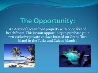
  • 1. 161 Acres of Oceanfront property with 6000 feet of beachfront! This is your opportunity to purchase your own exclusive private enclave located on Grand Turk Island in the Turks and Caicos Islands .
  • 2. Investment opportunity in the Turks and Caicos  The Turks & Caicos offer a number of advantages for savvy investors:  English speaking,  close proximity to the United States,  direct flights,  US currency,  based on English common law,  stable government,  NO income, estate, corporate, real estate TAX  …these are a few reasons the Turks and Caicos are attracting tourists and investors from all over the world.  Political Climate: The Turks and Caicos Islands are officially English speaking with a population close to 30,000 people made up of both "Belongers" (citizens) and Expatriates. The official currency is the US Dollar.  Presently, the Turks and Caicos Islands is an internal-governing Overseas Territory with a ministerial system of government. The country operates from the 2006 constitution which provides for a Governor appointed by HM the Queen, an Executive Council and a Legislative Council.  The Governor is responsible for external affairs, defense, internal security, offshore finance and certain other matters, but is otherwise normally required to act on the advice of the Executive Council.
  • 3.  The Executive Council deals with the affairs of the Government. It is presided over by His Excellency the Governor and is made up of the elected Ministers of Government. The Legislative Council is responsible for the passage of laws, monitoring Government policies and bringing to account the Executive Branch on behalf of the electorate.  Under this structure the Turks and Caicos enjoys a stable government guided by British Law. The Government is pro-development but is taking a responsible approach by learning from the experiences of other West Indies neighbors. Tourism is the number one industry with Offshore Financial services coming in second and growing.  Investment Climate: Traditionally the investment opportunities in Turks and Caicos have been based in real estate as witnessed by the recent high-end condo developments springing up along 12 mile Grace Bay Beach on Providenciales. As more people become familiar and comfortable with this country as a viable investment centre, opportunities for offshore investment structures and funds have become popular.  Part of this attraction is a well defined regulatory framework within which to operate a comprehensive range of financial activities including banking, insurance, trusts, mutual funds, investment dealing, companies and partnerships. TCI's modern legislation is complemented by an experienced professional infrastructure in the public and private sectors.  The Turks and Caicos Islands provide a full range of international banking and trust services. There are many licensed entities that carry out banking business, five licensed to carry out domestic and international services from within the islands. The Financial Services Commission (FSC) embodies in a single agency all regulatory aspects of the financial services industry. The FSC is responsible for licensing and supervising all finance-related operating entities to internationally accepted standards. The FSC also provides a centralized and cost-effective service for registering companies, partnerships, trademarks and patents in TCI.  As well, Investment Dealers legislation was recently introduced which provides for persons to be licensed as a fund manager, investment adviser or investment dealer.
  • 4. TCI Exclusive Attractions  The islands are arranged around the edges of two large limestone plateaus, the Turks Bank, with deep offshore waters that serve as major transit points for Humpback Whales, spotted Eagle rays, Manta Rays and Turtles. Anglers who are fishing for Tuna, Wahoo and Blue Marlin use these same rich waters. Bordering the edges of the islands are lines of coral reef and some of the most impressive walls of coral in the Caribbean. In the last decade on Turks and Caicos, divers have begun to discover some of the finest coral reefs and walls in the world. From the legendary walls of Grand Turk, West Caicos and Provo's Northwest Point to the historic wrecks south of Salt Cay, a dozen world-class walls have become Mecca for the serious diver. From late December through April, the entire Atlantic herd of 2,500 Humpback Whales pass through the shores on their annual migration to the Mouchoir Bank, just 20 - 30 miles southeast. During this period divers can listen to an underwater concert of the whales' songs. During the summer, divers encounter Manta Rays cruising the face of the walls. Encounters with Dolphin are not uncommon. The salt ponds and inland marshes serve as excellent feeding grounds for resident and migratory birds. Search for Great Blue Herons, Flamingos, Osprey and Pelicans alongside Egrets, Terns, Frigates, Boobies and other water birds. As part of the National Parks system more than twelve small cays have been set aside and protected for breeding grounds.
  • 5. Grand Turk Cruise Center  The Grand Turk Cruise Center, with direct beachfront access, is a first-class facility nestled among nearly 14 acres of landscaped grounds. With convenient changing rooms, showers and lockers for cruise line guests, cruise center visitors also can swim either in the ocean’s sparkling waters or in one of the largest pools in the Caribbean, stroll along the idyllic beach, relax in a chaise lounge or covered beach chair, and even rent a private cabana for the day and enjoy a massage. The cruise center is also home to a Jimmy Buffet’s Margaritaville, a fun and exciting place the whole family can enjoy. In the coming year, visitors to the cruise center will have the opportunity to peruse through a 45,000 sq. ft. shopping center which includes a 10,000 sq. ft. Dufry duty- free shop, and 35,000 sq. ft. of high end jewelry stores, an array of unique and world- renowned apparel and t-shirt stores, locally crafted souvenirs and gifts, and food and beverage facilities.
  • 6. Scuba Diving/Snorkeling  The Turks and Caicos Islands are surrounded by one of the most extensive coral reef systems worldwide (65 miles across and 200 miles long). As a result, the islands are consistently ranked as one of the premier diving locations in the world. Excellent visibility (up to 200 feet), pristine reefs, abundant tropical flora and fauna, fish and other marine life, quality diving services and easy conditions make the Turks and Caicos Islands a world class diving destination. There is exceptional wall diving starting in shallow turquoise water and dropping off into the deep blue giving a real thrill. The reef is relatively close to the beach which makes for accessible beach dives. Shipwrecks, old and new further increase the multiplicity of the islands as an outstanding diving destination. A 22 mile-wide channel, the Columbus Passage, separates the Turks Islands from the Caicos Islands. This 8,000 foot deep passage serves as major transit lines for migrating, spotted eagle rays, manta rays, turtles and dolphins. Summer waters (82 to 84 degrees Fahrenheit at the surface) are certainly warm enough for swimsuits, protection in the form of a light wet suit is welcomed by most divers. In the winter, water temperatures of 74 to 78 degrees Fahrenheit would suggest the use of a 2 to 3mm (1/8 to 3/16 inch) wetsuit. Computers are an advantage owing to the multi- level nature of diving in the Turks and Caicos.
  • 7. Grand Turk International Airport  Grand Turk is our country's capital and its international airport is served by daily flights from Providenciales/PLS on SkyKing and Air Turks & Caicos. Flying time is approximately 30 minutes. The airport offers full international entry and departures services, as well as a restaurant/bar, ground transportation, tourist information, and a full-service FBO for private planes. Visitors arriving via international flights and connecting to Grand Turk through Providenciales must first clear immigration and customs and claim baggage at PLS before making the connection to Grand Turk through the domestic departure area at the Provo Airport. Town Airport name ICAO IATA Usage Customs Runway IFR Rwy length Grand Turk I. Grand Turk Intl MBGT GDT Civ. Yes Paved Yes 6300 ft
  • 9. Hawk’s Nest Plantation Site Data  Oceanfront Lots: 17 @ +/- 1/3 to ½ acre (9 direct frontage, 8 rear)  Lagoon Lots: 49 @ +/- 1/3 to ½ acres  Hilltop Condo/Hotel w/Spa: 5.2 acres -20 units @ 3 bedrooms per  Oceanfront Condo/Hotel: 8.4 acres – 67 units @ 2 bedrooms per  Lagoon Condos: 352 Units @ 3 bedrooms per (bldg avg. 4 story)  Retail: 16,000 S.F. (Potential for maximum 50,000 S.F.)  Options: Casino Locations  Sale includes all site plans, environmental studies, hydraulic studies, engineering studies, and more.  Price available upon request For more information contact: William Korff, (843) 224-4221
  • 11. 2009 Bill Korff Hawkes Nest Plantation 1/1/2009 The Competition for Gaming
  • 12. The following is an excerpt from a 10-K SEC Filing, filed by SYZYGY ENTERTAINMENT LTD on 3/27/2008. Syzygy Entertainment Ltd, a Nevada corporation, formerly known as Triple Bay Industries, Inc., (“Syzygy” or “SYZG” or the “Company”), is publicly traded on the Over-The-Counter Bulletin Board market under the ticker symbol SYZG. Syzygy, through its acquisition of Rounders Ltd., a Turks and Caicos company and The Game International TCI, Ltd., a Turks and Caicos company (hereinafter collectively referred to as “Rounders”) is focused on the development and operation of destination gaming and resort facilities in the Turks and Caicos Islands. To date, Rounders has opened “The Players’ Club”, an up-market licensed casino, bar and slot parlor business on the growing tourist based island of Providenciales (known as “Provo”). Rounders has opened a second slot parlor on the island of Grand Turk, the capital of the Turks and Caicos Islands. It is located in Big Daddy’s Beach Shack, adjacent to the Carnival Cruise Line Facility. Subsequent to year end, Rounders has located 3 additional slot locations on North Caicos, as well as two additional locations near the airport on Provo. The Company discontinued operations of the business of manufacturing and selling disposable decontamination systems, which formed the basis of its operations before the acquisition of Rounders. Rounders, Ltd., a Turks and Caicos corporation and its affiliated company The Game International TCI, Ltd. (the “Company” or “Rounders”), were originally incorporated in 2006. Rounders has been placed in a position to work with a “belonger” (a native islander) associate with the goal of attracting a hotel, casino, gaming and poker room development to the islands. Rounders together with its partners and affiliated companies has identified an appropriately sized site located in the Grace Bay resort district that would be suitable for a gaming operation. Discussions are also underway in regards to the planning, financing, and construction of a destination hotel/gaming resort. The Island Opportunity The Turks & Caicos Islands (TCI) lies at the southern tip of the Bahamas, just 75 minutes by air or 575 miles Southeast of Miami and covers 193 square miles in the Atlantic Ocean. The Turks and Caicos Islands enjoy excellent air services from the US, Canada, Europe and the Caribbean, as well as reliable domestic services throughout the island chain. This accessibility combined with its close location to the US along with the fact that the Turks and Caicos Islands has the third largest coral reef system in the world, has led to the development of a very stable, growing, and profitable tourism industry over the last two decades. 4 Initially focusing on the diving industry, the island now encompasses both family beach vacations and increasing supplies a higher end product that caters to the discerning traveler seeking luxury accommodations. With a proliferation of upscale boutique resorts along with some of the best tropical beaches in the world, this steady incline in tourism and increasing accessibility has boosted property development in Turks & Caicos to an unprecedented scale. The island currently has two operating casinos with The Players Club being one of them. The Government recognizes the need to broaden the leisure and entertainment options for the visitor to the island. Casino-style activities represent an important amenity necessary to enhance Turks & Caicos Islands reputation as a premium “must visit” destination. The Players Club Rounders Ltd opened “The Players’ Club”, an up-market, licensed, casino, bar and slot parlor business on the growing tourist based island of Providenciales (known as “Provo”) in December of 2006. Provo, while having visitor numbers in the region of 160,000 tourists a year, does not have a licensed casino operating at this time, and adult recreational nightlife on island for tourists is limited to bars and restaurants. Located in the newly opened Queen Angel Resort, a top of the line gaming and poker facility has been completed. This facility has been outfitted with approximately 80 gaming machines providing 150 player seats, and the experience of playing games of chance as Texas Hold Em, Black Jack, Roulette, slots and a variety of other card and dice games. The Players Club provides a gaming experience in the environment of a fully staffed and operational bar. Licensing for Live Gaming
  • 13. On February 8, 2008, we received approval for a full-scale casino license, which is a major addition to our current offerings. A live gaming license allows us to operate a full scale casino and has shown a dramatic increase in volume at the current Players’ Club location since introduction. In addition, the live gaming license will allow us to pursue an international clientele and capture further revenue streams associated with that influx of volume. One of only two licenses issued in the country, we believe, with our current strategies, we are poised to seize control of the majority of the gaming dollars in the market. Licensing for Slot Parlor, 100 Machines for 5 Islands Rounders has petitioned, and the government has accepted, an application for Rounders to possess a license that would entitle the Company to have 100 gaming machines on Provo, Grand Turk, North, West, and Middle Caicos. In the first few months of operation of The Players Club, the Government has recognized the distinct advantages to facilities like The Players Club, versus games, 4 at a time, located in the bars and restaurants. 5 Grand Turk, a New Facility In December 2007, Rounders established the first four slot machines in Big Daddy’s Beach Shack, perfectly positioned next to the Carnival Cruise Line docking station. By partnering with the managers and operators of a newly opened, first class, Caribbean restaurant, located literally where the Carnival Cruise Ships signature blue beach chairs conclude, this restaurant property begins. The future development plans for the facility would hold up to 25 machines and a new building would be constructed to host the remaining machines. Grand Turk is the capital of the island and hosts most of the government operations and facilities. A mere 3,800 residents call Grand Turk home, and for the most part, it has been a “sleepy” little island stretching just 14 miles from north to south. Government officials expect the cruise ship dock to bring an additional 400,000 tourists to the island each year. Carnival Corp, the parent company of 12 cruise lines, invested $50 million dollars into a cruise ship boat dock, a 13 acre day use resort, featuring the largest Jimmy Buffet Margaritaville themed restaurant in the Caribbean. The newly opened dock can hold two cruise ships at one time. In addition, Carnival provided start up money to local shore excursion companies to help support tourist related activities including tour vehicles, horse back rides, snorkeling, diving, sightseeing, and many other events. Currently, there are approximately 2 cruise ships per week coming into port, carrying up to 3,400 passengers and 1,800 crew members for the larger ships. At the height of the coming tourist and cruise season, the Grand Turk port is expected to have one cruise ship per day coming into port. 75 Slot License Rounders has recently purchased an additional slot route gaming license in the Turks and Caicos that allows for the deployment of up to 25 gaming machines in a single location. Although the license does not specify which island it is specifically designated for, management believes it can be used on Provo, Grand Turk, or any other island in the Turks and Caicos. Rounders intends to develop a lower scale, “locals” facility to utilize this license. By partnering with an existing building owner, Rounders believes The Players Club, designed more like a traditional gaming facility, may be too formal for a lot of the local players, which have a more “laid back” Caribbean lifestyle. Local play on Provo alone was more than six million dollars in 2006 and is growing each year with the growth in tourism and employment. Grant of Poker License Rounders has been granted a one of a kind poker license for the Turks and Caicos. The Government recognized from the public relations success of the Johnny Chan Invitational, poker can be marketed as an internationally branded tourist destination event. The Players Club Turks and Caicos Classic in Association with the World Poker Tour From September 24, 2007 until October 1, 2007, Rounders hosted a World Poker Tour event on the island called The Players Club Turks and Caicos Classic. The event was held at Club Med and filmed for the Game Show Network, scheduled to be aired on May 19, 2008. Local partner, Rhynie Campbell came away with the first place prize of nearly $433,000. Since the completion of the event, the World Poker Tour has cancelled its agreement with Rounders, along with most other “foreign location” poker events that they held in 2007. 6
  • 14. Other Poker Events In advance of this proposed hotel/gaming resort development that would carry a branded poker room and as an introduction to poker tournaments on the island, an affiliated event promoter, The Game International Ltd, created and hosted the Johnny Chan TCI Invitational Poker Tournament, which was held in the Turks & Caicos Islands on September 9-16, 2006. The field included three World Series of Poker (“ WSOP”) champions, as seen on ESPN, Carlos “The Matador” Mortenson, Johnny Chan, and the most recent champion, crowned on August 11, 2006, Jamie Gold. Mr. Gold won a record 12 Million dollars in this years WSOP event. Other pro players included international names such as David “Devil Fish” Ulliot, Bob “The Butcher” Clark, Jeff Madsen, Bodog player David Williams, Amir Vahedi, Ian Frazer and a host of local players, with Jac Arama, Ashley Hayes and Michael Greco flying in from the UK for the Tournament . The eventual winner was the 2001 World Series of Poker champion, Carlos “The Matador” Mortenson . In 2007, in an effort to gain a World Poker Tour event, Rounders entered into an agreement with world renowned poker expert, Jack McClelland. Jack has over twenty-five years experience in poker and is currently the tournament director and poker room host at the Bellagio Las Vegas. Prior to this, he was at The World Series of Poker with Jack Binion for fifteen years and the Director for the Commerce Casino in Los Angeles for nine years. Other Las Vegas tournaments include The Grand Prix of Poker (Golden Nugget), Super Bowl of Poker (Caesars Palace), Queens Poker Classic (Four Queens) and Knights of the Round Table (Tropicana). Jack is also in the Poker Dealer Hall of Fame. The agreement with Mr. McClelland has been terminated. Hotel/Casino, Land and Development Rounders expects to purchase land that someday will host what would be considered a more traditional, hotel, resort and gaming facility. Although there are no current agreements, management believes partnering with a “name brand” hotel operator that would bring a reservation systems and operational management to the island, would be the best fit possible at this time. The recent approval for a full line class 3 gaming license, which allows live dealing and a reduced tax rate, adds substantial value to the company and in negotiations with hotel operators and brands. Other Slot Route Opportunities Rounders is exploring and evaluating other potential opportunities, both in the United States, Caribbean, Bermuda and Central America. 7 Employees At December 31, 2007, the Company’s CEO was the only part-time employee at the Company’s headquarters in Charlotte, North Carolina. At December 31, 2007, we had 15 full time and 7 part time employees in our gaming operations in the Turks and Caicos Islands. Our employees are not represented by a labor union. We have experienced no work stoppage and believe that our employee relationships are good.
  • 15. Identification of the Subject Property___________________________ Located on the island of Grand Turk, Hawkes Nest Plantation consists of 161 acres situated on the Southeast point of the island. The property has approximately 6,000 lineal feet of ocean frontage with panoramic views of the Atlantic Ocean and the uninhibited islands off the coast. Located adjacent to the north of the parcel is a newly constructed passenger terminal at the international airport providing a 7000’ runway. This destination is easily accessible from surrounding islands and the main land. Located adjacent to the west of the property is a new $ 50 Million dual cruise ship port capable of servicing 1,000’ vessels developed by Carnival Cruise Lines. Natural features on the site consist of beaches, uplands, varying elevations, 40’bluffs, mangroves, scrub brush and interior lands. The primary beaches are located off the southern portion of the property as well as a more private beach at the northern corner. In between the two sections of beach are bluffs which rise significantly above the rest of the property creating 360 degree views of the ocean and site. Executive Summary__________________________________________ Currently Planned is the Hawkes Nest Plantation Resort, an 865 – unit Five Star Master Planned Resort Community with a diversified mix of condo Hotel Rooms and Suites, Condominiums, and Single Family Estate Lots. Resort Amenities include a Casino, an 87-Slip Marina and 35,000 SF Marina Village. Located on the southwest corner are 17 oceanfront estate style single family lots. The configuration of lots, commonly referred to as “Flag Lots“, allow each owner their own private access point to the beach. To the east of the ocean front residences is a parcel dedicated for a high-end Hotel/Casino. With some of the best beaches this makes for a prime location. Adjacent to this Hotel and east of the main marina entrance sits a Boutique Hotel with a private yacht club capable of servicing large vessels. Hawkes Nest Plantation Resort A Turks and Caicos Island Development British West Indies
  • 16. Situated atop the bluffs and overlooking the ocean is another site for an exclusive Hotel with a private spa. At 5.2 acres the zoning would allow for 124 bedrooms. As this location is situated high above the resort site, the idea is to create a lower density high-end product. In order to make the product blend in with the natural topography, and to feel more exclusive, the densities have been reduced by half, creating sixty seven total units. On the interior lands of the site there will be canals cut to allow for boat access as well as the creation of two separate private islands. They will be divided into 47 single family estate home sites. The canals surrounding these homes vary between 150’ to upwards of 300’ creating a more natural feel to the waterways. This will allow for larger scale yachts to navigate. The entire perimeter of the estate island properties will be concrete bulk-heading for direct tie-ups. Average island lot frontage will range from 100’ to 300’. Surrounding the waterways are condominium units to create a “Marina Village“, look and feel. Consisting of approximately 244 units at three bedrooms per unit the buildings will vary in height from four to six stories to create architectural interests. The frontage of the condominiums will also be entirely bulk-headed allowing for each residence to have a slip in front of their units. Located at the main entrance to the site will be a retail marina village with shops, a convenience market, dining, shopping, etc. and a public plaza. The space will offer services and amenities for both residents of the site as well as potential passengers and other tourists. By the nature of its location, the retail village will serve to capture visitors close to the entrance of the property as well as yachting transits and keep the remaining properties exclusive. The mixed-use Properties mentioned above as well as the Retail and Commercial outfits provide an array of residual income streams in addition to the Real Estate Build-out. These income streams will span Land and Square Footage Leases, Property Management, Marina Operations, Wastewater Collection, Utilities, Telecommunications and Excursions. Government incentives are No Property Tax, No Income Tax, No Capital Gains Tax, Utility Licensing, Offshore Banking and other local Business incentives.
  • 17. Company Profile The property was acquired in August, 2004’. Since then the company has engaged in assembling a master planning team for the development of the plantation. Several work shops have been conducted to decide the best mixed use for the parcel along with many studies that illustrate the marina function and how it relates to the environment. To date, the conceptual Master Planning is complete as well as the program design for the Marina Basin. In addition, all Utility Infrastructure and design analysis for the parcel has been completed. A Mangrove Assessment is complete with key findings that support the design program. A Marine Baseline Assessment along with a Hydro-Flushing Analysis was also conducted and added to our master plan. Several feasibility studies have been performed over the years as the master plan was shaped into its current configuration. Development Team________________________________________ Master Planners EDSA Edsaplan.com Marine Engineers ATM Appliedtm.com Leisure Consultants Norton NortonConsulting.net Civil Engineers CSE Cse@tciway.tc General Contractors Johnston Int. Johnstonint.com Legal Team Miller, Simmons, O’Sullivan Mslaw@tciway.tc Project Impact_____________________________________________ The project proposed will create more than 750 new employment positions ranging from Hotel Staff, Casino Operators, Restaurant Staff, Retail Boutique Shops, Management Agents, Hospitality Staff, Marina Operations, Private Services, Tourism Services, Sport Fishing, Real Estate Sales and Service, Resort Operations and Upper Management. This will have a tremendous positive impact for the Local Government as well as the Local Island residence. These jobs will allow local residence to mitigate their travel to other outer islands for employment which in turn will gain their support for overall development. The Economic impact for the Local Government will be welcome by the Ministry as well as the Residents in conjunction with creating a sustainable project for growth and employment. Resort Project and the Environment__________________________ The development team has made a very strong effort to fully understand the current project proposed including the Specific Site and its Surrounding Environments. To date we have conducted the following studies that formed the basis of our Master Planned Development: A) Site Survey B) Topography Survey
  • 18. C) Site Reconnaissance D) Marine Benthic Survey E) Hydrology Flushing Analysis F) Mangrove Assessment G) Coastal Impact Assessment H) Marine Market Overview I) Wind & Hazard Study J) Feasibility Study K) Utility Infrastructure Design Support materials and individual studies, analysis, assessments and reports available upon request. Inquiries___________________________________________________ Please send your contact information to Bkorffpti@cs.com and reference Hawkes Nest Plantation Resort.
  • 19. BASELINE MANGROVE ASSESSMENT HAWKES NEST PROJECT SITE GRAND TURK TURKS & CAICOS ISLANDS APPLIED TECHNOLOGY AND MANAGEMENT, INC. 2770 NW 43 STREET, SUITE B GAINESVILLE, FL, 32606 352-375-8700
  • 20. 1.0 INTRODUCTION A baseline assessment of a mangrove wetland on the Hawkes Nest project site on Grand Turk was conducted April 10 through 12, 2007. The mangrove wetland includes approximately 37 acres and is located on the south side of South Creek, just off the eastern end of the runway for the Grand Turk airport. ATM personnel conducting the assessment were John Bossart and Dan Rich. John Waszak surveyed spot elevations. The purpose for the baseline assessment was to determine existing site conditions for subsequent use in master planning and impact analysis. Overall, the mangroves are healthy and of high quality, consisting of an intertidal zone of fringing red mangrove (Rhizophora mangle) and a basin mangrove forest with mixed red and black (Avicennia germinans) mangroves. The mangroves were associated with a shallow salt pond and intermittent patches of herbaceous high-marsh and salt barrens. Red and black mangrove trees are in excess of 30 feet tall within the basin forest, and black mangroves were measured with trunk diameters up to 30 inches. The basin forest is a prolific breeding ground for salt marsh mosquitoes; however, opportunities exist to combine mosquito control with recreational kayak trails. 1
  • 21. 2.0 MANGROVE MAPPING Mapping of the different plant communities within the mangrove wetland was conducted using an infrared satellite image dated 25 March 2003. Figure 1 provides a map delineating the different wetland components that were identified. Mapping units are described in the following sections. 2.1 RM (RED MANGROVE) The site includes both intertidal and non-tidal red mangrove stands. All intertidal red mangrove is located along the South Creek shoreline, where it occurs in a dense, monotypic stand with its characteristic tangled mass of prop roots. Red mangrove tree heights within the fringing forest are generally 10 to 15 feet; however, some trees near the western end of the fringe (near the airport) are more than 30 feet tall. Several other monotypic stands of red mangrove occur in the non-tidal, basin zone of the mangrove wetland. Tree heights in these areas were approximately 10 to 15 feet. Photo 1. Intertidal red mangrove fringe along South Creek. Turtle grass (Thalassia testudinum) is growing on the bottom among the roots. 2
  • 22. 3
  • 23. 2.2 BM – SHRUBBY (BLACK MANGROVE, SHRUB-SIZED) Shrub-sized black mangroves are located north of the large salt pond. These mangroves were generally no more than 6 to 8 feet in height. The individual shrubs were scattered in distribution with open ground between them. Photo 2. Shrubby black mangroves to north of salt pond 2.3 RM/BM – TALL (MIXED RED AND BLACK MANGROVE, WITH RM DOMINANT, HEIGHT TO 30+ FEET) This mapping unit was identified within a single stand at the south end of the basin zone. This area is densely vegetated with both red and black mangroves, with the red mangrove dominating. Tree heights were in excess of 30 feet. Black mangroves were generally larger than the red mangroves, with some of the black mangroves having trunk diameters up to 30 inches. 4
  • 24. Photo 3. Red mangrove prop roots within the mixed red and black mangrove stand. Survey rod height is 8 feet. 2.4 BM/RM – TALL (MIXED BLACK AND RED MANGROVE, WITH BM DOMINANT, HEIGHT TO 30+ FEET) This mapping unit was similar in structure to the RM/BM – Tall mapping unit, however, in this case, the black mangroves outnumbered the red mangroves. Tree heights were more than 30 feet, but the understory was much more open than in the areas dominated by red mangrove because there were fewer red mangrove prop roots. 5
  • 25. Photo 4. Black mangrove dominated portion of mixed red and black mangrove stand. Pencil- like structures are black mangrove pneumatophores, which are part of the black mangrove’s root system and provide aeration to the underlying roots that are buried in the saturated, anoxic mud. 2.5 HIGH MARSH High marsh is a common wetland component around mangrove-dominated areas and is characterized by low-growing, herbaceous vegetation. At Hawkes Nest, the herbaceous, high marsh vegetation is dominated by saltgrass (Distichlis spicata), saltwort (Batis maritima), glasswort (Salicornia spp.), and sea purslane (Sesuvium portulacastrum). High marsh is inundated infrequently, such as during spring tides or weather-driven high water events. Excessive evaporation maintains a very high soil salinity. 2.6 SALT POND The Hawkes Nest site includes a shallow salt pond typical of the Bahamas archipelago. The water depth was very shallow during the field survey, so birds could wade at generally any location within the pond. However, the water level probably rises in 6
  • 26. response to rainfall. As is typical with these types of salt ponds, during periods of low rainfall, the pond water probably evaporates completely, leaving an exposed mud flat that would be favored by foraging shorebirds. Pond water salinity in these types of ponds is highly variable in response to rainfall and evaporation. The pond water salinity on the day of the site survey was 35 ppt, which is the same as ocean water. Pond water salinity can fall to nearly zero in response to heavy rains. As the water evaporates, the remaining water becomes increasingly saline. Salinities well in excess of 100 ppt are common in salt ponds, which is a primary reason their bottoms remain unvegetated. Photo 5. View to the north from southeast corner of salt pond at Hawkes Nest site. The birds near the black mangrove are two white-cheeked pintail ducks and a black-necked stilt. 7
  • 27. Photo 6. View to the southeast from west shoreline of salt pond at Hawkes Nest project site. 2.7 SALT BARREN Like high marsh, salt barrens are commonly found in mangrove systems. Salt barrens are unvegetated, or sparsely vegetated, areas of highly saline sands. The sparse vegetation that does grow consists of the same species as found in the high marsh, i.e., saltgrass (Distichlis spicata), saltwort (Batis maritima), glasswort (Salicornia spp.), and sea purslane (Sesuvium portulacastrum). 8
  • 28. 3.0 TIDE RANGE IN RELATION TO MANGROVE ELEVATIONS Zonation of red and black mangroves is largely determined by their location in relation to the tide range. Red mangroves typically occur at lower elevations (mean high water and below), so they are tidally inundated more frequently and to a deeper depth than black mangroves, which occur at elevations at or above mean high water. Fringing mangrove systems are directly connected to the tidal waters. Basin mangrove systems are at least partially isolated from the tide, usually by a low-relief ridge that is only crested by higher tides, such as spring tides. Tidal datums were measured using a tide gauge set in South Creek. The gauge was in place for 41 days from February 28 through April 10, 2007. Summary statistics for standard tide parameters are provided in Table 1. Table 1. Summary Statistics for Tide Data Collected in South Creek MAX 2.12 feet MHHW 1.54 MHW 1.32 MTL 0.42 MLW -0.46 MLLW -0.57 MIN -0.95 The tide range between MHW and MLW is 1.78 feet, with a total mean tide range of 2.11 feet. The range between maximum and minimum water elevations is 3.07 feet. Figure 2 provides a stage-duration curve for the tide data. Spot elevations at selected locations within the mangroves were measured using an RTK GPS. A number of spot elevations of the submerged bottom of South Creek were measured along the waterward edge of the fringing mangrove system, right along the tree drip line. Bottom elevations along the mangrove fringe ranged from -0.6 to -1.6 feet, with an average elevation of -1.17 feet. Based on the measured tides, water depths along the waterward edge of the fringing mangrove system are 2.49 feet during a mean high water event (MHW = +1.32 feet) and up to 2.71 feet during a mean higher high water event (MHHW = +1.54 feet). 9
  • 29. The elevation of the submerged bottom along the mangrove fringe is indicated on the stage-duration curve (Figure 2). Even during the lowest of low tides (-0.95 foot), there is still an average depth of 0.22 foot along the waterward edge of the mangrove fringe. Average water depths are 0.71 foot during mean low tide events. This means that the mangrove prop roots along the waterward edge are always submerged and can support the growth of epiphytic algae and invertebrates, and provide protective habitat for juvenile fish. In contrast to the mangrove fringe, spot elevations measured within the shrubby black mangroves within the basin zone ranged from +1.2 to +1.6 feet, which is generally at or above mean high water (Figure 2). Tidal inundation through the basin zone is intermittent, at best occurring only during spring tide or other high tide events. The majority of the time the ground in the basin mangrove zone is exposed. Red mangrove prop roots, as well as all the other plant stems in the basin zone, do not show water lines or colonization by epiphytic algae or invertebrates. -2.5 -2 -1.5 -1 -0.5 0 0.5 1 1.5 2 2.5 0 10 20 30 40 50 60 70 80 90 10 Duration TideStage(ft) 0 Ground elevation in shrubby black mangrove Submerged bottom elevation along mangrove fringe MHW Mean Tide MLW Figure 2. Stage-Duration Curve for Tide Data Collected in South Creek 28 February through 10 April 2007. 10
  • 30. 4.0 RECOMMENDATIONS Development at the Hawkes Nest project site will largely surround the existing mangrove wetland, including excavation of a marina basin in adjacent uplands to the west and excavation of a flushing channel across the mangrove fringe along South Creek. However, the mangrove wetland is a prolific source of salt marsh mosquitoes, which must be brought under control to accommodate the surrounding development. A series of flushing channels would open the area to tidal inundation and serve to reduce mosquito breeding areas at the source. If appropriately designed and constructed, these tidal channels may also be used as kayak trails and become a valuable ecotourism amenity. Finally, these tidal channels may also provide the opportunity to accrue mitigation credit for use in offsetting impacts in cutting the flushing channel through the mangrove fringe, as well as the nearshore waters. A recommendation for combining mosquito control flushing with kayak trails is provided below, as well as a discussion regarding potential mitigation credit. The mangrove wetland provides the conditions to breed enormous numbers of salt marsh mosquitoes. Unlike fresh water mosquitoes that lay eggs in containers of stagnant water (old tires, flower pots, and roadside ditches being common examples), salt marsh mosquitoes lay their eggs on damp mud, such as that found within black mangrove forests and high marshes. The female salt marsh mosquito is adept at locating the micro-depressions in the wetland surface that will fill with water and remain flooded after rain or an unusually high tide (e.g., a spring tide). After the female mosquito deposits her eggs on the damp mud within the mangroves, the eggs lie dormant until a flooding event occurs, at which time the eggs hatch and the cycle repeats. Mosquito source control depends on removing the opportunities for mosquito eggs to lie dormant. Flushing channels that expose egg-laying sites to tidal inundation directly remove the eggs and also allow access for small fish to prey on both eggs and mosquito larvae. Figure 3 provides a conceptual plan for a series of tidal flushing channels through the mangroves. The goal of the flushing channels is to convert much of the basin mangrove to an intertidal system. The main channels are intended to be augmented by much smaller secondary channels that would specifically target mosquito 11
  • 31. 12
  • 32. breeding sites that are identified by comprehensive field reconnaissance by mosquito control specialists. Figure 4 provides a conceptual cross-section illustrating potential design components for the main tidal channels. The main tidal channels will have variable widths, anticipated to be between 15 and 30 feet. Channels will be excavated to a depth sufficient to maintain at least a 2-foot water depth even at lower low tide. This will facilitate fish movement and provide for kayak access. The main channels will be lined with red mangroves planted along variable-width planting areas. During rising tides, water will overtop the channel banks and flood the adjacent red mangrove planting zones. During a falling tide, water will drain from the mangrove planting areas and, at low tide, will be confined within the tidal channels. The planted ground elevations within the mangrove zones will be intermediate between high and low tides. The channels and mangrove planting areas will be excavated out of the underlying limestone. Planting areas will be overexcavated by a minimum of 4 feet and then backfilled with sand overlain by muck. A rock sill between the channels and the planting areas will retain the sand and muck and prevent it from being washed into the channel during falling tides. Only red mangroves will be planted in the restoration areas. Red mangroves are the best adapted to deep tidal inundation, and their dense, tangled prop roots provide the most valuable marine nursery habitat and contribute the most to marine fisheries. If planted properly, the red mangroves will grow up and over the channels, forming a tunnel effect that will add to the aesthetics while kayaking (Photo 7). Boardwalks and observation platforms can also be incorporated into the concept. Photo 7. Example of a kayak trail overtopped by red mangroves. 13
  • 33. 14
  • 34. Wildlife habitat diversity within the mangrove restoration areas can also be increased by incorporating a number of small, open ponds. These ponds would be randomly located within the mangrove planting areas and have variable shapes, widths, and depths. Like the tidal channels, these ponds will be excavated from the rock substrate, but not backfilled with sand and muck. However, the ponds will not be connected to the tidal channel network so they will hold water during low tide, allowing them to serve as refugia for fish. During high tides, when the mangrove prop roots are flooded, the fish will migrate from their low tide refugia and forage among the prop roots. In addition, the outer pond edges will include shallow, variable-width littoral zones to provide foraging areas for shorebirds and wading birds. Littoral shelves can be included along some secondary tidal channel edges. The primary contribution of red mangroves to marine productivity is the intertidal nursery habitat provided by their prop roots. For the Hawkes Nest mangroves, this contribution to marine productivity is limited to the red mangrove fringe along South Creek. The submerged prop roots of these mangroves are richly colonized by epiphytic algae and invertebrates, which provide a food source for juvenile fish. The tangle maze of submerged prop roots also provides cover for the juvenile fish. In contrast, mangroves within the basin zone are not regularly inundated by tides and do not directly contribute to marine productivity. Because these mangroves are isolated from a direct connection to tidal inundation, they do not provide any habitat for juvenile fish. Despite the presence of red mangroves within the basin zone, their prop roots are rarely submerged and, therefore, do not support any colonization by epiphytic algae or invertebrates. By maximizing the area that is completely flooded during every high tide, small fish will have maximum access to all areas and will be able to prey on mosquito eggs and larvae. However, not all of the existing basin mangrove can or should be converted to intertidal mangrove, and additional mosquito control options will have to be employed. These options include the installation of smaller, secondary tidal channels that will allow fish access to isolated sites, the application of mosquito larvae pathogens to defined breeding trouble spots, and the use of mosquito traps. The smaller, secondary channels would not be intended for kayak use but would be routed to specifically target mosquito-breeding sites. Such sites would be identified by 15
  • 35. comprehensive reconnaissance of the entire mangrove site. While extensive excavation and grading will be necessary to install the main channels, red mangrove planting areas, and any additional ponds that may be incorporated, the secondary channels can be installed with a rotary ditcher. This unit is typically pulled behind a tractor fitted with oversized, low-pressure tires that will support the tractor on the soft wetland surface. The rotary ditcher simultaneously cuts a small ditch and side casts the excavated material as a fine film of mud. Determining the feasibility of this construction method will require consideration of the depth to the underlying limestone. Mosquito breeding sites within the mangroves that remain outside the reach of tidal inundation may also be controlled by mosquito larvae pathogens that are added to known breeding sites after rains or high tide events. These pathogens are a freeze- dried bacteria, Bacillus thuringensis israeliensis, or BTI, that is marketed as a compressed briquette. These briquettes are thrown into the standing water where the mosquitoes are known to breed. The water reconstitutes the dried bacteria, which then attack and kill the mosquito larvae. The BTI has the advantage of being very target specific, unlike a general insecticide. For mosquitoes that escape the source control measures, CO2 generating mosquito traps have been shown to very effective elsewhere in the Turks and Caicos, specifically Parrot Cay. These traps use bottled propane to produce CO2, which attracts mosquitoes and funnels them into a trap, where they are removed from the breeding population. Continual operation of the traps causes the local mosquito population to crash after several weeks and continued operation prevents the breeding population from becoming reestablished. A formal mosquito management plan may be an appropriate consideration for the overall resort planning. Dr. David Dame, a retired University of Florida entomologist and former president of the American Mosquito Control Association is a recommended consultant. He travels worldwide consulting on mosquito control issues for projects such as Hawkes Nest. 16
  • 36. Hydrodynamic and Flushing Analysis Proposed Marina at Hawkes Nest Plantation, GrandTurk, BWI PREPARED BY: APPLIED TECHNOLOGY AND MANAGEMENT, INC. CHARLESTON, SC USA PREPARED FOR: MR. JOHN SKERCHEK, PORTRAIT PROPERTIES II, INC. MAY 2007
  • 37. II Table of Contents 1. INTRODUCTION.......................................................................................................................................................1 1.1. SITE LOCATION AND DESCRIPTION ...........................................................................................................1 1.2. REPORT OUTLINE.......................................................................................................................................1 2. MODEL DESCRIPTION ..........................................................................................................................................4 3. MODEL SET-UP.........................................................................................................................................................6 3.1. MODEL GEOMETRY ...................................................................................................................................6 3.2. BATHYMETRY ............................................................................................................................................6 3.3. TIDAL FORCING..........................................................................................................................................6 3.4. WIND ..........................................................................................................................................................7 4. MODEL RESULTS ..................................................................................................................................................13 4.1. HYDRODYNAMIC MODEL RESULTS ........................................................................................................13 4.2. FLUSHING MODEL RESULTS....................................................................................................................13 5. CONCLUSIONS AND RECOMMENDATIONS...............................................................................................18 REFERENCES .....................................................................................................................................................................19
  • 38. III List of Figures FIGURE 1-1 LOCATION MAP OF PROPOSED MARINA AT HAWKES NEST PLANTATION, GRAND TURK, BWI................................2 FIGURE 1-2 SKETCH OF PROPOSED MARINA LAYOUT. ....................................................................................................................3 FIGURE 3-1 MODEL GRID OF THE PROPOSED MARINA – SCENARIO 1.............................................................................................9 FIGURE 3-2 MODEL GRID OF THE PROPOSED MARINA – SCENARIOS 2 AND 3..............................................................................10 FIGURE 3-3 MODEL GRID DEPTHS..................................................................................................................................................11 FIGURE 3-4 MEASURED WATER SURFACE ELEVATIONS AT PROJECT SITE....................................................................................12 FIGURE 4-1 SIMULATED CURRENT MAGNITUDES DURING PEAK FLOOD CONDITION...................................................................15 FIGURE 4-2 SIMULATED CURRENT MAGNITUDES DURING PEAK EBB CONDITION........................................................................16 FIGURE 4-3 SIMULATED DYE CONCENTRATION IN MARINA BASIN VERSUS TIME........................................................................17
  • 39. IV List of Tables TABLE 3-1WIND DATA, GRAND TURK ISLAND..............................................................................................................................8 TABLE 4-1 PREDICTED FLUSHING TIMES FOR THE PROPOSED MARINA BASIN AND FLUSHING OPTIONS. ....................................14
  • 40. 1 Hydrodynamic and Flushing Analysis Proposed Marina at Hawkes Nest Plantation, Grand Turk, BWI 1. INTRODUCTION This hydrodynamic and flushing analysis was completed to address circulation and flushing concerns for the proposed marina development at Hawkes Nest Plantation, Grand Turk, GWI. Adequate flushing reduces the potential for the stagnation of water in the marina basin, helps to maintain the biological productivity, and reduces the potential for toxic accumulation in bottom sediment. Maintaining water quality within a basin depends primarily on flushing as determined by water circulation within the basin, and minimizing sources of pollution in the basin. This study utilized a numerical model to simulate the flushing of conservative pollutants in the proposed marina system over time. The results of the simulations were used to determine if the basin exhibits good circulation and flushing characteristics. 1.1. Site Location and Description Hawkes Nest Plantation is located near the southern end of Grand Turk Island, Turks and Caicos Island, BWI, as shown in Figure 1-1. The layout of the proposed marina is shown in Figure 1-2. The new marina basin will be excavated to depths of 11 ft below Mean Low Water (MLW). Two flushing and entrance channels, with depths of 5 ft and 12 ft (MLW), respectively, connect the marina basin to the open water. 1.2. Report Outline This report presents the model study in the following sections: • Section 2 presents a detailed description of the model used for the flushing study; • Section 3 presents the model set-up and describes the data input to the model; • Section 4 presents the hydrodynamic and flushing model results; and • Section 5 provides the report conclusions.
  • 41. Figure 1-1 Location map of proposed marina at Hawkes Nest Plantation, Grand Turk, BWI. Project site
  • 42. Figure 1-2 Sketch of proposed marina layout.
  • 43. 4 2. MODEL DESCRIPTION The Environmental Fluid Dynamics Code (EFDC) was used for this project. EFDC is a general purpose modeling package for simulating two or three-dimensional flow, transport and biogeochemical process in surface water systems including: rivers, lakes, estuaries, reservoirs, wetlands and near shore to shelf scale coastal regions. The EFDC model was originally developed at the Virginia Institute of Marine Science for estuarine and coastal applications and is considered public domain software. In addition to hydrodynamic, salinity, and temperature transport simulation capabilities, EFDC is capable of simulating cohesive and noncohesive sediment transport, near field and far field discharge dilution from multiple sources, eutrophication processes, the transport and fate of toxic contaminants in the water and sediment phases, and the transport and fate of various finfish and shellfish. Special enhancements to the hydrodynamic portion of the code, including: vegetation resistance, drying and wetting, hydraulic structure representation, wave- current boundary layer interaction and wave induced currents, allowing refined modeling of wetland and marsh systems, controlled flow systems, and nearshore wave induced currents and sediment transport. The following description is from the introduction to the EFDC User Manual (Hamrick, 1996): The physics of the EFDC model, and many aspects of the computational scheme, are equivalent to the widely used Blumberg- Mellor model (Blumberg and Mellor, 1987) and the U.S. Army Corps of Engineers’ CH3D or Chesapeake Bay model (Johnson, et al, 1993). The EFDC model solves the three-dimensional, vertically hydrostatic, free surface, turbulent averaged equations of motions for a variable density fluid. Dynamically coupled transport equations for turbulent kinetic energy, turbulent length scale, salinity and temperature are also solved. The two turbulence parameter transport equations implement the Mellor-Yamda level 2.5 turbulence closure scheme (Mellor and Yamada, 1982; Galperin et al, 1988). The EFDC model uses a stretched or sigma vertical coordinate and Cartesian or curvilinear, orthogonal horizontal coordinates. The numerical scheme employed in EFDC to solve the equations of motion uses second order accurate spatial finite differencing on a staggered or C grid. The model’s time integration employs a second order accurate three-time level, finite difference scheme with an internal-external mode splitting procedure to separate the internal shear or baroclinic mode from the external free surface gravity wave or barotropic mode. The external mode solution is semi-implicit, and simultaneously computes the two-dimensional surface elevation field by a preconditioned conjugate gradient procedure. The external solution is completed by the calculation of the depth average barotropic velocities using the new surface elevation field. The model’s semi-implicit external solution allows large time steps that are constrained only by the stability criteria of the explicit central difference or high order upwind advection scheme (Smolarkiewicz and Margolin, 1993) used for the nonlinear accelerations. Horizontal
  • 44. 5 boundary conditions for the external mode solution include potions for simultaneously specifying the surface elevation only, the characteristic of an incoming wave (Bennett and McIntosh, 1982), free radiation of an outgoing wave (Bennett, 1976) or the normal volumetric flux on arbitrary portions of the boundary. The EFDC model’s internal momentum equation solution, at the same time step as the external, is implicit with respect to vertical diffusion. The internal solution of the momentum equations is in terms of the vertical profile of shear stress and velocity shear, which results in the simplest and most accurate form of the baroclinic pressure gradients and eliminates the over-determined character of alternate internal mode formulations. Time splitting inherent in the three time level scheme is controlled by periodic insertion of a second order accurate two time level trapezoidal step. The EFDC model is also readily configured as a two-dimensional mode in either the horizontal or vertical planes. The EFDC model implements a second order accurate in space and time, mass conservation fractional step solution scheme for the Eulerian transport equations for salinity, temperature, suspended sediment, water quality constituents and toxic contaminants. The transport equations are temporally integrated at the same time step or twice the time step of the momentum equation solution (Smolarkiewicz and Margolin, 1993). The advective step of the transport solution uses either the central difference scheme used in the Blumberg-Mellor model or a hierarchy of positive definite upwind difference schemes. The highest accuracy upwind scheme, second order accurate in space and time, is base on a flux corrected transport version of Smolarkiewicz’s multidimensional positive definite advection transport algorithm numerical diffusion. The horizontal diffusion step, if required, is explicit in time, while the vertical diffusion step is implicit. Horizontal boundary conditions include time variable material inflow concentrations, upwinded outflow, and a damping relation specification of climatological boundary concentration. For the temperature transport equation, the NOAA Geophysical Fluid Dynamics Laboratory’s atmospheric heat exchange model (Rosati and Miyakoda, 1988) is implemented.
  • 45. 6 3. MODEL SET-UP The model set-up requires the user to build a model grid based on the geometry of the study area (i.e., the shorelines and bathymetry) and develop the model inputs (i.e., the boundary forcings and model coefficients). The boundary forcings used for this study include the offshore tidal elevations and wind. In support of the model application, ATM conducted field investigations in the vicinity of the proposed project from February 28 to April 10, 2005. The purpose of the data collection was to characterize the depths at the project site and measure the tidal signals near the project site. 3.1. Model Geometry The model geometry is defined by the shorelines of Grand Turk Island and the proposed marina basin. The marina basin boundaries were digitized and imported from a TIF drawing file created by Portrait Properties II, LLC. After the marina basin was merged with the island shoreline, the shoreline was translated to local grid coordinates based on the coordinates of marina basin. The shorelines were then transformed into a GIS basemap and used as a guide for development of the numerical model grid. Three scenarios with different locations of flushing and entrance channels were simulated in this study. In these three scenarios, the entrance channel is 200 ft wide and 12 ft deep relative to Mean Low Water (MLW), and the flushing channel is 100 ft wide and 5 ft deep relative to MLW. Their computational grids are presented in Figures 3-1 and 3-2. The model grid covers the entire marina basin and two entrance and flushing channels. The grid cells range in size from 15 meters wide in the flushing and entrance channels to 10 meters wide in the marina basin and 200 meters in the area away from the project site. The higher resolution in the project area was desired in order to accurately simulate the current pattern in the project site. The furthest north and west cells at the seaside are considered as the boundary cells in the model. 3.2. Bathymetry Local bathymetry was input to the model grid by using the GIS editor to select grid cells and specify the grid cell depth. March 1, 2007 survey data collected by ATM in the study area were used to define the model grid depths in the nearshore areas. The bathymetry in the marina basin and entrance and flushing channels was based on the proposed dredge depth of 11 ft (3.3 m), 12 ft (3.6 m) and 5 ft (1.5 m) relative to MLW. The model grid depths are shown in Figure 3-3. 3.3. Tidal Forcing Water surface elevations in the model were forced at the north and south ocean boundaries. Tidal measurements were collected at the project site between February 28 and April 10, 2007. Figure 3-4 shows the tidal records measured at this location. Local tides are semi- diurnal (i.e., two high tides and two low tides per day), with an inequality between successive highs and lows. The US Army Corps of Engineers ADCIRC model simulated tidal database for the western Atlantic basin was used to evaluate tidal phasing in the vicinity of Grand Turk
  • 46. 7 Island. Based on this analysis, it was determined that it is reasonable to assume that there is no tidal phase difference between the model boundaries. 3.4. Wind Wind data is available for Grand Turk Island, based on hourly surface wind observations between November 1954 and November 1968 made by the United States Air Force. The values of mean wind speed and percent occurrence of wind are greatest from due east (i.e., trade winds). Of significant importance is the 90-degree sector between northeast and southeast, which accounts for 89% of the average annual wind energy. These data, along with the local shoreline orientation and nearby sheltering features indicate that the prevailing winds at the project site would blow along the channel from the east. Table 3-1 provides wind data from Grand Turk. The 6.7m/s wind condition is exceeded 89 percent of the time, and therefore can be used to represent a minimum wind condition. Therefore, a steady minimum average wind of 6.7m/s from the east was used in this study.
  • 47. 8 Table 3-1 Wind data, Grand Turk Island.
  • 48. Figure 3-1 Model grid of the proposed marina – Scenario 1. Flushing Channel Entrance Channel
  • 49. Figure 3-2 Model grid of the proposed marina – Scenarios 2 and 3. Flushing Channel Entrance Channel Entrance Channel Flushing Channel
  • 50. Figure 3-3 Model grid depths for Scenario 1 (shown as meters below MLW).
  • 51. Figure 3-4 Measured water surface elevations at project site. -1.00 -0.80 -0.60 -0.40 -0.20 0.00 0.20 0.40 0.60 0.80 1.00 2/28/07 3/5/07 3/10/07 3/15/07 3/20/07 3/25/07 3/30/07 4/4/07 4/9/07 Day WaterSurfaceElevation(m)
  • 52. 13 4. MODEL RESULTS 4.1. Hydrodynamic Model Results The hydrodynamic model was used to simulate the flow of water in and out of the marina basin over a period of ten days for the three scenarios discussed in Section 3.1 (grids shown in Figures 3-1 and 3-2). The tides used for the model simulation are shown in Figure 3-3. The model simulation started with the neap portion of the tidal cycle. This results in a somewhat conservative analysis, since the larger range of spring tide conditions would result in increased tidal flows and flushing. Scenario 3 generated the largest currents in the basin, as compared to the other two scenarios. In general, currents during neap tides are smaller than during spring tides, which is due to higher tidal ranges associated with spring tides. Simulated current magnitudes for Scenario 3 during peak flood and peak ebb for spring tide are shown in Figures 4-1 and 4-2. The results indicate that the currents in the basin will be much smaller than in the channels. The maximum speeds are 0.12 m/s in the north entrance channel, 0.04 m/s in the south flushing channel, and 0.04 m/s or less in the basin. 4.2. Flushing Model Results The U.S. Environmental Protection Agency (USEPA) recommends that in order to provide reasonable assurance that water quality will not be a concern, flushing times should not exceed four days (USEPA, 1985). However, it should be noted that flushing times in excess of four days do not necessarily indicate poor water quality or that applicable water quality standards will be violated. Clark (1983) recommends that a maximum time of 2-4 days should be safe as a design criterion while a period of more than 10 days should be considered an unacceptable flushing time. The generally accepted concentration target for these flushing times, based on the concentration of a conservative tracer (as utilized herein), is 10 percent of initial loading. For this study, the entire marina basin was assumed to have an initial concentration of 100 percent (i.e., a unit concentration of 1). 10 percent tracer remaining after four days or less will be considered good flushing, 10 percent remaining after 4 to 10 days will be considered marginal flushing, and greater than 10 days will be considered unacceptable flushing. The overall dye concentration in the entire basin under steady easterly wind condition at different time is summarized in a plot of the relative initial pollutant mass remaining in the marina basin versus time (Figure 4-3). For Scenario 1, the proposed marina basin will flush to 58.1% of the initial dye remaining after 4 days and 38.2% remaining after 10 days, which is considered a poor flushing rate. For Scenario 2, the proposed basin will flush to 10% of the initial dye remaining within 2.9 days, which is considered a good flushing rate.
  • 53. 14 For Scenario 3, the results show that the initial dye concentration in the proposed marina basin will disperses quickly and will flush to 10% remain only within 1.2 days. Furthermore, it will flush to 0.3% remaining after 4 days. It is considered a very good flushing rate. Overall, the study results indicate that proposed marina basin will flush very quickly if the entrance and flushing channels are designed at the right location. Therefore, the basin will exhibit good water quality and clarity as long as best management practices (BMPs) are employed to minimize pollution sources to the basin. Table 4-1 Predicted flushing times for the proposed marina basin and flushing options. Flushing Options Scenario Entrance channel Flushing channel Percent Initial Concentration after 4 days Time Required to Reach 10% Initial Concentration 1 At north In the middle 58.1% > 10 days 2 At north At south 3.1% 2.9 days 3 At south At north 0.3% 1.2 days
  • 54. Figure 4-1 Simulated current magnitude during peak flood conditions.
  • 55. Figure 4-2 Simulated current magnitude during peak ebb conditions.
  • 56. Figure 4-3 Simulated dye concentration in marina basin versus time. 0 10 20 30 40 50 60 70 80 90 100 0 1 2 3 4 5 6 7 8 9 10 Time (days) PercentInitialMassRemaining Scenario 1 Scenario 2 Scenario 3
  • 57. 18 5. CONCLUSIONS AND RECOMMENDATIONS This study was undertaken to evaluate the circulation and flushing characteristics and potential impact of the proposed marina at Hawkes Nest Plantation, Grand Turk, BWI. The U.S. Environmental Protection Agency (USEPA) recommends that in order to provide reasonable assurance that water quality will not be a concern, flushing times should not exceed four days (USEPA, 1985). However, it should be noted that flushing times in excess of four days do not necessarily indicate poor water quality or that applicable water quality standards will be violated. Clark (1983) recommends that a maximum time of 2-4 days should be safe as a design criterion while a period of more than 10 days should be considered an unacceptable flushing time. The study utilized a state-of-the-art hydrodynamic and mass transport model to evaluate the flushing characteristics of the proposed marina design. The model included tidal forcing and wind forcing based on the analysis of the measured water surface elevations and wind at the project site. The model simulations indicate that the proposed marina basin will flush very quickly if the entrance and flushing channels are designed at the right location. With a 200 ft wide 12 ft deep entrance channel located at the south of the basin and a 100 ft wide 5 ft deep flushing channel located at the north of the basin, the proposed marina basin will flush with 90 percent exchange of the marina waters within 1.2 days under typical trade wind conditions. With this configuration, the marina will exhibit very good flushing characteristics, and it is expected that the basin will exhibit good water quality and clarity as long as best management practices (BMPs) are employed to minimize pollution sources to the basin.
  • 58. 19 REFERENCES Applied Technology & Management, Inc. 2004: Hydrodynamic and flushing study for Proposed Development at Leeward, Providenciales, ATM, Charleston, SC. Bennett, A. F., 1976: Open boundary conditions for dispersive waves. J. Atmos. Sci., 32, 176-182. Bennett, A. F., and P. C. McIntosh, 1982: Open ocean modeling as an inverse problem: tidal theory. J. Phys. Ocean., 12, 1004-1018. Blumberg, A. F., and G. L. Mellor, 1987: A description of a three-dimensional coastal ocean circulation model. In: Three-Dimensional Coastal Ocean Models, Coastal and Estuarine Science, Vol. 4. (Heaps, N. S., ed.) American Geophysical Union, pp. 1-19. Hamrick, J.M. 1996: User’s manual for the environmental fluid dynamics computer code. Special Report No. 331 in Applied Marine Science and Ocean Engineering. Department of Physical Sciences, School of Marine Science, Virginia Institute of Marine Science, The College of William and Mary. Gloucester Point, VA. Johnson, B. H., K. W. Kim, R. E. Heath, B. B. Hsieh, and H. L. Butler, 1993: Validation of three-dimensional hydrodynamic model of Chesapeake Bay. J. Hyd. Engrg., 119, 2-20. Mellor, G. L., and T. Yamada. 1982: Development of a turbulence closure model for geophysical fluid problems. Rev. Geophys. Space Phys., 20, 851-875. Rosati, A. K., and K. Miyakoda, 1988: A general circulation model for upper ocean simulation. J. Phys. Ocean., 18, 1601-1626. Smolarkiewicz, P. K., and L. G. Margolin, 1993: On forward-in-time differencing for fluids: extension to a curvilinear framework. Mon. Weather Rev., 121, 1847-1859. U.S. Army Corps of Engineers. 1984: "Shore Protection Manual." Coastal Research Center. USACE Waterways Experiment Station. Vicksburg, Mississippi. US Environmental Protection Agency. 1985: Coastal Marinas Assessment Handbook. Atlanta: NEPA Compliance Section, USEPA Region IV, 570 p.
  • 59. A P P L I E D T E C H N O L O G Y & M A N A G E M E N T , I N C . Marine Benthic Resource Baseline Assessment Hawkes Nest, Grand Turk British West Indies Prepared for: Hawkes Nest Enterprises Incorporated by: Applied Technology and Management May 15, 2007
  • 60. Table of Contents 1. Summary……………………………………………………………………………………….3 2. Approach……………………………………………………………………………………….4 3. Marine Communities………………………………………………………………………….4 4. Marine Species………………………………………………………………………………..8 5. Resource Uses………………………………………………………………………………..5 6. Protective Legislation and Regulations……………………………………………………12 7. Potential Environmental Issues and Considerations…………………………………….17 8. Recommendations…………………………………………………………………………..18 Figures Figure 1. Proposed Site of Hawkes Nest Plantation. Figure 2. Proposed Channel Alignment and Beach Enhancement Sites. Figure 3. Benthic Survey Areas for April 2007 Field Reconnaissance. Figure 4. Notable Marine Features and Habitats (April 2007). Figure 5. Coastal Rock Community. Figure 6. Seagrass Communities in the Project Area. Figure 7. Macroalgae Flat Communities in the Project Area. Figure 8. Finger Coral Reef Communities in the Project Area. Figure 9. Soft Coral Reef Communities in the Project Area. Figure 10. Fringing Reef Communities in the Project Area. Figure 11. Mangrove Communities in the Project Area. Figure 12. Protected Species in the Project Area. Appendix A. Marine Species List…………………………………………………...32 2
  • 61. 3 1. Summary ATM performed marine ecological assessments of the property’s shoreline and offshore marine areas during the week of April 9 through April 13, 2007. The property is located along the southeast coast of Grand Turk, adjacent to the airport and a salt pond, or salina, to the west; the northern edge of the property is bounded by the South Creek National Park. The site includes roughly 160 acres of upland area and spans 6,000 linear feet of open shoreline. Figure 1 depicts the property boundary based on information provided to date. Figure 2 shows the proposed channel locations and beach enhancement area. The benthic resource survey was limited to areas potentially affected by channel dredging and beach enhancement (See Figure 3). The marine environment consists of a low energy system of seagrass, macroalgae flats, patch and fringing reefs, finger coral reef, mangrove nursery and soft coral communities. Dense turtlegrass (Thalassia testudinum), shoal grass (Halodule wrightii) and manatee grass (Syringodium filiforme) were abundant, as shown on the map of the marine communities (Figure 4). The most common hard corals include club finger coral (Porites sp.), lesser starlet coral (Siderastrea radians) and mustard coral (Porites astroides). A list of all species observed in the project vicinity is provided in Appendix A. General ecological health was found to be very good, with few existing impacts beyond marine debris on the shorelines and occasionally in the water in the form of derelict fishing nets. The reefs and seagrass beds were thriving, with no visible signs of damage from poor water quality, vessel anchors, storms, or major diseases. The area currently supports recreational uses such as snorkeling, sightseeing and kayaking, along with some artisanal fishing. These uses are not incompatible with the project goals, however, existing snorkeling sites should be considered during channel planning to avoid user conflicts. This report includes the results of field investigations and potential issues related to the proposed development. This fatal-flaw level analysis determined there are substantial ecological considerations, including dense seagrass beds, thriving coral reefs, and the South Creek National Park, that may adversely affect the ability of developing the site.
  • 62. 2. Approach The marine assessment was conducted by Sabeena Beg, a project environmental scientist from ATM. Ms. Beg has conducted a number of ecological surveys in Florida, the Bahamas, and the British West Indies (Anguilla and Turks and Caicos) for the past 10 years. The field investigations were limited to a level of research necessary to highlight any potential issues for future development of the property and are not considered sufficient for an Environmental Impact Assessment (EIA). The Owner provided copies of the most recent conceptual master plan of the subject property (dated 13 June 2005, EDSA), which ATM used to roughly delineate the property limits. Based on the assessment’s purpose and limited field time and budget, the investigation included three components: 1) Acquisition and review of 2005 aerial photography (Figure 2); 2) Literature search of flora and fauna that are protected by local, national, and/or international regulations and agreements; and 3) Reconnaissance-level benthic habitat field investigations. Marine assessments were conducted in the areas shown on Figure 3, in which current conditions, species, habitats, and ecologically notable features were documented. Extensive EIA level mapping of habitat boundaries and inventories of flora and fauna were beyond the scope of this assessment, however, photographs and Global Positioning System (GPS) coordinates were taken where protected species were observed. 3. Marine Communities The marine survey focused on the immediate project area and the project sphere of influence, located in the waters proposed for an entrance channel and flushing channel for the marina, as well as areas of proposed beach improvements. Six marine habitat types were identified as depicted on Figure 4: • Coastal Rock / Intertidal Zone (Figure 5) • Seagrass (Figure 6) • Macroalgae Flats (Figure 7) • Finger Coral Reef (Figure 8) 4
  • 63. • Soft Coral Reefs (Figure 9) • Patch and Fringing Reefs (Figure 10) • Mangrove Nursery (Figure 11) The approximate community boundaries run in a general shore-parallel zonation from shallow to deep, with a band of seagrass and calcareous algae, then finger coral (Porites) reef, soft coral beds, and seagrass further from shore, then transitioning into a fringing reef community. Between each community were dense to moderate seagrass beds. Figures 5 through 11 depict representative photographs from each community type. 3.1 Coastal Rock / Intertidal Zone The proposed shoreline enhancement project is located within this community. The coastal rock community serves the purpose of protecting landward structures and communities from storm-induced erosion, and typically forms where strong wave action has scoured fine sediments from the shore. On the eastern edges of the property lies two small pocket beaches segmented by exposed limestone rock with small cliffs, named Gun Hill. Gun Hill is a remnant of colonial era gun or observation emplacement and is the second highest elevation on Grand Turk. The coastal rock community appeared healthy and without major anthropogenic impacts, except debris. No threatened or endangered species were observed. Environmental conditions are severe in the coastal rock community, hence species diversity and species populations are low when compared to other natural communities. Mollusks, such as periwinkles (Littorina littorina), and chitons (Class Polyplacophora) were observed, and marine crabs were found in the small tidal pools (Figure 5). Intertidal communities supported fuzzy chitons (Acanthopleura granulata), beaded periwinkle snails (Tectarius muricatus), and nimble spray crabs (Percnon gibbesi). Several birds were foraging along the shoreline, such as ruddy turnstones (Arenaria interpres) and oystercatchers (Haematopus sp.). White-tailed tropic birds (Phaethon lepturus dorotheae), magnificent frigatebirds (Fregata magnificens), osprey (Pandion haliaetus) and reddish egrets (Egretta rufescens) were seen overhead. 5
  • 64. 3.2 Seagrass Communities Dense seagrass beds were found throughout the survey area. They were mostly comprised of turtle grass (Thalassia testudinum) but also contained manatee grass (Syringodium filiforme). In some shallow locations, shoal grass (Halodule wrightii) was also intermixed. Crustaceans, mollusks, juvenile fish such as the striped parrotfish (Scarus iserti), and a green sea turtle (Chelonia mydas) were observed foraging in this habitat. Close to shore, the seagrass communities were dense and mixed with a variety of macroalgae. Neogoniolithon spectabile, a crustose coralline algae, was interspersed throughout the shoreline communities at both the north and south locations where beach enhancements and a flushing channel may be located (Figure 2). In the deeper water areas, a dense bed of turtle and manatee grass paralleled the shoreline, then became less dense to sparse farther east. Seagrass communities dominated the project area and were present in all areas of proposed development. In the South Creek area, turtle grass beds were moderate with scattered lugworm (Arenicola spp.) mounds throughout the community. There were occasional patches of shoal grass in small sandy areas. Anemones and sea cucumbers were common in this area, as well as juvenile fish. Father east toward the fringing reefs, the area around the reefs were comprised of sand, with a transition in deeper waters to macroalgae-flat dominated areas, then dense seagrass. All seagrass areas appeared healthy and had a rich diversity of species. 3.3 Finger coral (Porites spp.) reef In the shallow waters along the eastern coastline, branched finger coral (Porites furcata) reefs are encountered approximately 200 feet offshore. Other dominant species associated with the reef include thin finger coral (Porites divaricata), mustard coral (Porites astreoides), and crustose coralline algae. These platform shaped reefs support a large assemblage of fish and provide shelter for many juveniles such as damselfishes and parrotfish. The reefs are found in shallow waters of 3 – 4 feet in depth. Seagrass immediately surrounds this community. 6
  • 65. 3.4 Soft Coral reef Soft coral communities dominated by sea whips (Plexaura, Plexaurella, and Pseudoplexaura spp.), rods (Pterogorgia spp.), fans (Gorgonia spp.) and plumes (Psuedopterogorgia spp.) paralleled the shoreline east of the finger coral reef and at the south end of the proposed flushing channel. The soft coral reefs provided habitat for many juvenile and some adult fish. Burrows in the bases of the substrate on which the corals grew sheltered spiny lobster and squirrelfish. The corals had no signs of disease. 3.5 Patch and Fringing Reefs Patch and fringing reefs supported a diverse assemblage of corals and sponges dominated by large elkhorn coral, occasional staghorn coral, and purple sea fans. The corals within the study area were large, healthy and robust with slight evidence of bleaching. Species of fish noted included goldentail moray eel (Gymnothorax miliaris), foureye butterflyfish (Chaetodon capistratus), and juvenile striped parrotfish. A juvenile hawksbill sea turtle (Eretmochelys imbricata) was resting in a crevice. Surrounding the fringing reef, sand bottom with macroalgae transitioned into dense seagrass. 3.6 Mangrove Within the survey area, red mangroves (Rhizophora mangle) line South Creek. The prop-roots of these mangroves serve as a nursery area for juvenile fish species; juvenile gray and schoolmaster snappers were noted in this area. The surrounding seagrass communities provide additional cover and transitional habitat to the reef system. Both habitats are important for lobster, conch, and reef fish, all of which were observed among the mangrove prop-roots. From east to west along the channel, small mangroves were beginning to take root. This system appears quite healthy, with the exception of human debris. Additional information on the mangrove community can be found in the Baseline Mangrove Assessment (ATM, 2007). 4. Marine Species A total of 110 marine species were identified during the surveys, and additional surveys would likely reveal more species present in this pristine area. A species list is included 7
  • 66. as Appendix A with common and scientific name, type of organism, relative abundance, and habitat type. Throughout this report, the common and scientific names are given first, followed by the common name for the remainder, unless there is no common name as is the case for certain algae and invertebrates. The most common fish species are shown in Table 1. All other fish species, as well as coral, and other invertebrates, are listed in Appendix A. Table 1. Most Common Fishes Sighted during April 2007 Surveys. Scientific Name Common Name Thalassoma bifasciatum Bluehead Wrasse Haemulon flavolineatum French Grunt Haemulon sciurus Bluestriped Grunt Holocentrus rufus Longspine Squirrelfish Holocentrus sp. Squirrelfish Lutjanus apodus Schoolmaster Snapper Mulloidichthys martinicus Spotted Goatfish Scarus inserti Striped Parrotfish 4.1 Protected Species Considerations The Turks and Caicos are currently adopting endangered species legislation that was not available during the time of this report. It will include provisions for the Convention on International Trade in Endangered Species (CITES), which does not apply to development activities in the country, just to trade in wildlife products from protected species such as conch and sea turtle. While the TCI do not yet have a formal endangered species program, the International Union for the Conservation of Nature (IUCN)’s “Red List” is a common reference used when discussing species of conservation concern. The IUCN, also known as the World Conservation Union, establishes levels of threats from highest to lowest as Critically Endangered, Endangered, Vulnerable, Near Threatened, Lower Risk, and Data Deficient as shown in the status column in Table 2. Table 2 lists all marine species listed for conservation concern by the IUCN in the Turks and Caicos (updated 2006). 8
  • 67. Table 2. Marine Fauna Protected by the IUCN Potentially Present Within the Assessment Area (bold indicates species observed.) Common name Scientific Name Status Rough-toothed dolphin Steno bredanensis Data Deficient Manatee Trichechus manatus Vulnerable Green turtle Chelonia mydas Endangered Leatherback turtle Dermochelys coriacea Critically Endangered Hawksbill turtle Eretmochelys imbricata Critcally Endangered Spotted eagle ray Aetobatus narinari Near Threatened Blacktip shark Carcharinus limbatus Lower Risk Bull shark Carcharinus leucas Lower Risk Tiger shark Galeocerdo cuvier Lower Risk Shortfin mako Isurus oxyrinchus Lower Risk Lemon shark Negaprion brevirostris Lower Risk Blue shark Prionace glauca Lower Risk Scalloped hammerhead Sphyrna lewini Lower Risk Smooth hammerhead Sphyrna zygaena Lower Risk Oceanic whitetip shark Carcharhinus longimanus Vulnerable Nurse shark Ginglymostoma cirratum Data Deficient Whale shark Rhincodon typus Vulnerable Red grouper Epinephelus morio Near Threatened Goliath grouper Epinephelus itajara Critically Endangered Nassau grouper Epinephelus striatus Endangered Yellowfin grouper Mycteroperca venenosa Near Threatened Rainbow parrotfish Scarus guacamaia Vulnerable Queen triggerfish Balistes vetula Vulnerable Marbled grouper Dermatolepis inermis Vulnerable Hogfish Lachnolaimus maximus Vulnerable Cubera snapper Lutjanus cyanopterus Vulnerable Mutton snapper Lutjanus analis Vulnerable Albacore tuna Thunnus alalunga Data Deficient Bigeye tuna Thunnus obesus Vulnerable Northern bluefin tuna Thunnus thynnus Data Deficient Two marine species listed by the IUCN were sighted during field surveys: green and hawksbill sea turtles. Photographs of protected species and species of conservation concern are shown in Figure 12. 4.1.1 Sea Turtles The fringing reefs and sea grass beds found offshore of the Hawkes Nest project site support foraging opportunities for at least four species of sea turtles: leatherback, green, loggerhead and hawksbill. The leatherback, green and hawksbill sea turtles are designated as endangered and the loggerhead sea turtle is considered threatened under 9
  • 68. the Endangered Species Act in the United States and by the IUCN. Sea turtles seen during surveys include a juvenile hawksbill resting in a crevice of a fringing reef, and an adult green sea turtle foraging in the seagrass beds. No sea turtle tracks were seen along the project area beaches during the survey; however, nesting surveys were not conducted. Because sea turtle nesting season in Grand Turk is from approximately March to October, encountering a nest during the April survey was possible. The main threats to sea turtles include harvesting of nesting turtles and eggs, incidental capture by fishing gear, loss of beach nesting habitats, lighting near beaches that can mislead hatchlings away from the sea, and marine debris, such as fishing nets and plastics that can entangle or choke turtles. Sea turtle population recovery is complicated by legal hunting of turtles in the TCI. Hawksbill turtles are hunted for their tortoiseshell, while green turtles are hunted for their meat. Because hawksbill turtles live on a diet of sponges and many of the sponges are toxic, their meat can be toxic as well. Green turtle hatchlings and juveniles are omnivorous, while the adults live on a diet of seagrass and algae. Green sea turtles do not reach sexual maturity until age 25; the age of maturity for hawksbill turtles is unknown. Approximately 1 in 1000 hatchlings reaches maturity, so the removal of an adult or subadult turtle can cause a significant population impact. Green and hawksbill sea turtles depend on sand beaches for nesting sites and their young need beaches that are not lit during hatching season or they will become disoriented. Sea turtle hatchlings instinctively orient towards the brightest part of the night sky when they emerge from their nest. In the absence of human development, the breaking ocean surf and reflected night sky on the water are the brightest spots on the beach. Potential adverse impacts of the project on sea turtles include boat/turtle collision, erosion of existing possible nesting beaches, disturbance of nesting females, light pollution from development which could result in an increase in abandoned nesting attempts and disorientation of turtle hatchlings, and the modification of foraging habitat. 10
  • 69. 4.1.2 Other Species of Concern Queen Conch Queen conchs were observed in the seagrass beds near the project site. The queen conch is listed as a threatened species by CITES and the TCI have regulations concerning their harvest to protect and conserve this species as a fishery (Fisheries Protection Ordinance 1998). The species has significantly declined throughout the Bahamas and Caribbean and increasingly strict regulations regarding their take are aimed at reducing overfishing. Overfishing and habitat disruption are the main cause of this drastic decline, and their import is controlled by CITES signatory nations. Conchs reach sexual maturity at age 5 and may live for 40 years. Conchs need seagrass habitat to successfully reproduce. They live in shallow habitats and are easy to find and capture, which makes them vulnerable to fishing pressure. Elkhorn and Staghorn Coral The project area includes healthy elkhorn reefs and occasional staghorn individuals as shown in Figure 12. Elkhorn and staghorn coral are listed as threatened under the United States’ Endangered Species Act due to their decline and their important role as reef building species (US Department of Commerce 2006). While they are not currently protected in the TCI, impacts to these species should be avoided. Both species transplant well and can be relocated from the impact area if the channel dredging location overlaps with their local distribution. 5. Resource Uses The project vicinity is currently used primarily for recreational purposes, snorkeling, sightseeing and kayaking. Dive boats with large groups of people were seen regularly in the area while the assessment was being conducted. The bay at the entrance to South Creek provides many snorkeling opportunities. The shallow waters and robust fringing reef allow visitors to see a variety of species. Since 1996, cruise ships have been bringing snorkelers to the area’s reefs and to a popular stingray experience near the protected island of Gibb Cay. Kayakers were seen within the South Creek National Park. Cruise ship passengers were also seen on personal watercraft in the area. Upland areas are visited by cruise passengers via guided safari tours and all-terrain vehicles. 11
  • 70. The project area is used by local fisherman for spear-fishing and free diving for fish and conch offshore. During the survey, a fisherman was seen just outside of the project area. The boat captain explained that the reefs in the marine area are fished by the local fishermen. In one area, large piles of conch shells were seen near the reef. No active commercial fishing was noted. Expected signs of commercial fishing or significant artisanal fishing would include fish traps, small boats operating in the area carrying fishing gear, or other signs of activity. This was seen on the other side of the island. A few juvenile commercially harvested fish species were seen in the project area, including juvenile snapper, lobster, barracuda, parrotfish, and conch. 6. Protective Legislation and Regulations This fatal-flaw level analysis includes a literature review of relevant protective legislation for the area. Relevant policies (and date enacted) include: • Turks and Caicos Islands National Park Ordinance enacted May 15, 1998 • Guidelines for the protection of Humpback Whales and Other Cetaceans - 2004 • Turks and Caicos Islands Demarcation Buoys, Access Lanes, Dive and Snorkel Mooring, Scientific Monitoring Marker, Park Boundaries, Training Zones and Swim Zones. • Turks and Caicos Islands Coast Protection Ordinance - May 15, 1998 • Turks and Caicos Islands Fisheries Protection Ordinance - May 15, 1998 • Turks and Caicos Islands Fisheries Limits Ordinance - May 15, 1998 • Turks and Caicos Islands National Trust Ordinance - May 15, 1998 • Turks and Caicos Islands Plant Protection Ordinance - May 15, 1998 • Wild Birds Protection Ordinance - May 15, 1998 • Minerals (Exploration and Exploitation) Ordinance - May 15, 1998 The main policy relevant to the project is the Park Ordinance, due to the South Creek National Park which may be located just north of the property. During investigations and literature review, it was unclear where the park boundaries may overlap with the proposed project and additional information is necessary to establish the park boundary locations. While consideration must be given to the Park Ordinance, the policy does not necessarily present an insurmountable obstacle to site development because the recreational uses may be integrated with the park. 12
  • 71. 6.1 Natural Parks, Protected Areas, and Marine Reserves There are eleven National Parks, eleven Nature Reserves and four Sanctuaries in the TCI. All of these are marine protected areas, except five of the Nature Reserves. Grand Turk has three national parks and one sanctuary: Columbus Landfall Marine National Park, Grand Turk Cays Land and Sea National Park (including Gibbs, Penniston, Martin, Alonza, and Pinzon Cays), South Creek National Park, and Long Cay Sanctuary. South Creek National Park includes the South Creek estuary (excluding Eves Hill) and is an important wetland area, recognized for its value as the least impacted of the 125 wetlands of international importance listed under the Ramsar Convention by the UK Government. The National Park Ordinance (1998) describes the boundaries of South Creek as follows: “An area of 183 acres in Grand Turk bounded by a line across the mouth of South Creek extending along the coast to the north of Materson’s Point, along the northern boundary of Parcel 10411/4 and the western boundary of Parcel 10411/3 until this meets a wall, in a south-westerly direction along the wall to the south side of the road to Materson’s Point, along the south side of this road in a westerly direction until it’s junction with a track, leading to the eastern end of Grand Turk Airport, along the east side of this track around the end of the runway to the canal leading from Hawks Pond Salina to South Creek. Around the Crown land holdings 10505/5 and 6 comprising mangroves and wetlands following the west side of the track ending at South Creek; then in an easterly direction to the starting point and excluding Parcel 10410/3 Eves Hill which is in private ownership.” This description and location, however, conflicts with that portrayed on the Park’s website. The National Parks Ordinance allows some types of development including buildings, marinas and other construction to facilitate enjoyment by the public. Government’s policy states that “the government is prepared to use any available Crown land (other than national parks, nature reserves, sanctuaries and areas of historical interest) for development in the right circumstances”. Minimizing impacts from the proposed development on the National Park should be helpful in Government discussions about appropriate development of the site. 13
  • 72. 7. Potential Environmental Issues and Considerations 7.1 Marina Marine resources of the pristine waters of Grand Turk form the core of local livelihood and water-based tourism. A variety of marine resources, including seagrass beds and coral reefs, were observed throughout the project area. The proposed interior marina basin and associated channels would have a large impact on these marine resources. Excavation of the entire marina basin footprint would be required to provide adequate water depth within the basin, along with excavation of an access channel connecting to “deep” water and a flushing channel to facilitate water exchange within the basin. While the total impact to resources cannot be quantified at this time, it is likely to be significant and will present challenges to environmental approval. A more precise estimate of unavoidable resource impacts will have to be made, along with proposals for mitigation such as coral and seagrass transplants, etc. An issue related to a substantial marina facility at this location is the potential impact to the National Park, local usage site, and tourist based underwater activities that are popular in this in this area of Grand Turk. Depending on the level of vessel traffic, the marina may negatively impact local dive charters and inhibit other existing commercial ventures that utilize these waters. 7.2 Entrance and Flushing Channels Dredging channels for navigation and flushing will have impacts to seagrasses, coral reefs, and other marine habitats shown in Figure 4. Figure 2 shows the proposed locations for an entrance channel and/or flushing channels as Channel 1 (to the north) and 2 (to the south). Main habitats of concern located in the Channel 1 area include dense seagrass beds, as well as a pristine patch reef community shown in Figure 4. In the area of Channel 2, a healthy soft coral reef is found that extends well to the south, and appears to be almost continuous along the shoreline. Additional reefs exist to the south of the survey area, and are labeled on navigation charts as Talbot Shoal and Gun Reef. Either channel option would result in marine impacts. The areas proposed for the either channel are in healthy condition. The affected habitats are linked and the channel may 14