2. CONTEXT FOR T.O.D.
WESTERN CONTEXT
• SOLUTION TO SRAWL
• REDUCTION OF CONSUMTION OF RESOURCES
• IMPROVING AIR QAULITY
• PROVIDING EQUITY IN URBAN AREAS
• REPAIRING SOCIAL SYSTEMS BY CREATING HEALTHY
NEIGHBORHOODS
UTTIPEC
3. CONTEXT FOR T.O.D.
DELHI CONTEXT
• IMPROVING ACCESS TO PUBLIC TRANSIT
• REDUCE USE OF AUTOMOBILE
• PROVIDING ACCESSIBILITY INFRASTRUCTURE FOR MAJORITY
OF RESIDENTS
• INCREASE PERCEPTION OF EQUITY
• FACILITATE MORE DEMOCRATIC DEVELOPMENT
UTTIPEC
4. Transit Oriented Development (TOD):
1 2 3
Landuse-Transport Transit System Public Realm
Coordination: Design: Design:
• Make it accessible to • Make Rapid Public Transit • Design public realm for
maximum people; (RPT) RAPID and pedestrians, cyclists and
Live work and play FREQUENT. public transit users.
destinations near stations
• Provide safe, quick, easy • Make car-use difficult
• Eliminate private transport interchanges between (car-pool priority lanes,
use as feeder service; modes & good paratransit. congestion pricing,
provide efficient Feeder expensive parking &
Services. • Make Public Transport licenses, etc.)
cheaper/ affordable.
UTTIPEC
5. Current Policies:
In accordance with the changing transportation scenario in
India over the last two decades, there has been a change in the
policies at, both, national level and in Delhi.
a) National Urban Transport Policy – 2006, recommends:
i. Integrated land use and transport policy
ii. Priority to the use of public transport & non-motorized
vehicles
b) Master-plan for Delhi – 2021, proposes:
i. MPD 2021 has given a thrust on redevelopment and
redensification of existing urban areas and city improvement.
It calls for a comprehensive redevelopment strategy for
accommodating a large population, and strengthening of
infrastructure facilities.
UTTIPEC
6. What are the Steps to
achieve these goals for Delhi?
onlyromi@gmail.com
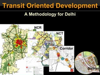
7. First, we need to….
Think Macro (= Vision)
Then Act Micro (= Implementation)
NCR
NCT
Corridor
District
9. Planners with high level GIS expertise
Transportation modelers
Urban Economic Strategists
Urban designers (with knowledge of form based codes)
Environmental Engineers
Planners with local and international policy knowledge.
Architects
Graphic Designers
Step 1. TOD : Visioning & Goal Setting
UTTIPEC
10. a) A Strategic Plan + “Implementation Body” for Delhi:
UTTIPEC
External
Consultants
MPD-2021 Implementation TOD Vision &
Framework Body Strategic Plan
UTTIPEC
11. Vision for a “World Class” Delhi
• Safe
• Clean with usable ‘green’ areas
• Well Connected & Walkable
• Accessible Affordable Housing
• Civic Pride
• Democratic & Transparent
UTTIPEC
12. Critical Goals of Delhi are directly related to its Urban Design & Planning:
UTTIPEC
13. Transportation modelers
Urban Economic Strategists
Planners with high level GIS expertise
Planners with local and international policy knowledge.
Urban designers
Hydrology and Water Engineers
Environmental Engineers
Architects
Graphic Designers
Step 2. Coordinating Landuse & Transportation
UTTIPEC
14. Current Disjointed and Uncoordinated Planning
Why are these planned Separately ?
TRANPORTATION + LANDUSE + INFRASTRUCTURE
MUST BE designed and implemented together – complimenting each other.
Otherwise they will ALL FAIL….
UTTIPEC
15. Integrated Modeling & Planning
INPUTS ALTERNATIVES OUTPUTS
Infrastructure
Jobs & Housing Profile
Investments SCENARIO A
MCD; PWD; NDMC
Infrastructure Cost
Transport Network SCENARIO B Land Consumption
DIMTS/ RITES
Equity Consequences
Development SCENARIO C
Pattern VMT
Landuse Data: DDA MPD 2021
Transport Emissions
Population and
Employment
Projection,
DELHI 2021 Combined Multimodal Landuse
Transportation & Transport Plan TOD overlay
Landuse Modeling
17. Develop Scenarios for Landuse allocation Zones….
RITES have developed 4 scenarios besides modeling MPD2021
UTTIPEC
18. The current DDA 2021 Plan:
NO COORDINATION exists between Planned Landuses and Transportation Corridors!
UTTIPEC
19. Auto-Oriented City SHIFT Transit-Oriented City
Interchange
BRT
7 min walk Rail/ Metro
20. High Density Mixed Use within 5-min walk of stations…
Transit Node
Express
Bus Route
Reason for success of BRT in Curitiba:
Maximum people Live, Work & Play
UTTIPEC
within 5-min walk of RAPID TRANSIT Stations
21. Make Transit accessible within 5-min walk…
The Transportation - Landuse Pyramid (Curitiba):
Reason for success of BRT in Curitiba:
UTTIPEC
22. High Density Mixed Use within 5-min walk of stations…
Delhi Curitiba
Segregated Uses, Random density Mixed Uses, Transit-Density Pyramid
• Maximum People can Live & Work & Play - within 5-minute Walk from Transit Stations
• Reverse Commutes will ensure transit use 24x7.
UTTIPEC
24. Urban designers (with knowledge of form based codes)
Urban Economic Strategists
Planners with local + international policy knowledge.
Architects
Environmental Engineers
Planners with high level GIS expertise
Graphic Designers
Step 3. Public Process & TOD Typologies
onlyromi@gmail.com
25. Landuse Mixes and Density Distribution Strategy:
- Develop TOD Typologies
ONE SIZE DOES NOT FIT ALL!
Step1: Market study and documentation of areas within 5 min walk and 5-min bike ride from the stations.
Step 2: Development Codes
Re
ver
se
Com
mu
te
Delhi Development Masterplan with Example: TOD Typologies developed for Denver TOD Strategy Plan
7-minute walk from Metro overlaid.
UTTIPEC
26. Feeder Transit is the ‘key’ to success of Rapid Transit
Free Maps Rapid Transit
Rapid
Transit
DIMMTS
Feeders
Develop more
Feeder Transit
UTTIPEC
27. Public Participation Process
The Process for the Plan
Station Area Plan
Land Use Scenario
SUMMARIZE STATION DRAFT STAION
AREA AREA LAND
Implementation
NEIGHBORHOOD
PLANS CONCEPTS USE PLAN &
Zoning changes
ZONING
Circulation
Open Space
• Education Session
• Public Charrettes
• Affordable Housing Targets
• Draft plan review by UTTIPEC
• Final Review by UTTIPEC
UTTIPEC
Source: PB PlaceMaking
28. Landuse Mixes and Density Distribution Strategy:
- Create a Urban Design “Specific” Plans for each Station Area
Station Area Specific Plans must be in keeping with the
broader vision and overall strategic plan for the corridor
and the city.
Example: TOD Typologies developed for Denver TOD Strategy Plan
UTTIPEC
29. Urban designers (with knowledge of form based codes)
Urban Economic Strategists
Planners with local + international policy knowledge.
Architects
Environmental Engineers
Graphic Designers
Step 4. Development Codes
onlyromi@gmail.com
30. Landuse Mixes and Density Distribution Strategy:
- Create TOD Guidelines
Create desired character sketches
Phase 3:
•Phase 1:
2:
••Capital Metro’s 40 acreNetwork and Station
•Establishing the Street Parking Site near
High density Mixed-use development
with walkable blocks.
serving Retail.
Lakeline Station.
Source: vmwp.com
Source: vmwp.com
UTTIPEC
31. Develop a “Form-based” Zoning Code
… which provides Control of Public Realm, but allows flexibility of landuses.
Source: Wikipedia
32. “Form-based” Code: Control of Public Streets
Streets for Trains, Buses, Pedestrians, cars and storm
water drainage! Source: Arup Bio-swales
Built-to-edge Buildings for Safety & Comfort and human
scale.
33. “Form-based” Code: Control of Public interfaces
S
Source: http://en.wikipedia.org/wiki/Form-based_codes
onlyromi@gmail.com
34. Critical Zoning Laws to be changed:
S
Remove Setbacks, Regulate Design Street Guidelines
Require Entries on sidewalks Maximum Block Widths, for pedestrians, not cars!
Minimum Frontages
80
.
ax
-1
10
m
00 M
M 00
m
m 80
-1
ax Sidewalks, Bio-swales
..
Multimodal, pedestrian-oriented.
Streets for Trains, Buses, cars
Building Entries/ windows on Smaller blocks, interconnected and Pedestrians.
Sidewalk (eyes on the street - streets create shorter travel routes for
provides safety for pedestrians) pedestrians. Built-to-edge Buildings for Safety
& Comfort.
onlyromi@gmail.com
35. Urban designers (with knowledge of form based codes)
Urban Economic Strategists
Planners with local + international policy knowledge.
Environmental Engineers
Transportation Engineers
Graphic Designers
Step 5. Implementation and Monitoring
onlyromi@gmail.com
36. a) A Strategic Plan + “Implementation Body” for Delhi:
IMPLEMENTED EXAMPLE:
(Reconnecting America) - for City of Denver
The Transit Oriented Development (TOD) Strategic Plan for
DENVER is a guide for prioritizing the planning and implementation
activities of the City and County of Denver related to transit
planning and transit-oriented development. City Council, Planning
Board, departmental management, staff, and others will use it to:
• Set priorities for where City resources should be directed in the
short, mid and long-terms;
• Identify effective implementation tools, policies and strategies to
facilitate transit oriented development where appropriate; and
• Ensure close coordination among City departments, staff and
others as they undertake planning and implementation activities
related to transit and transit-oriented development.
External
Consultants
http://www.denvergov.org/TOD/TODStrategicPlan/tabid/395267/Default.aspx
onlyromi@gmail.com
37. b) Mechanism - Private Investment for Public Benefit:
Designated Open Space
Provision and Maintenance.
Taxes Requisites
Private Upgradation of slums
Investment and/ or provisions for
Incentives Bonuses
low-income communities.
Provision of schools and
civic facilities.
Maintenance of public realm.
UTTIPEC
38. TOD ‘Test Sites’ for implementation:
Test Site: Dwarka Corridor/
Dwarka Sector 21 • Greenfield TOD sites
• Infill TOD sites
• Redevelopment TOD sites
Dwarka
Current State
Moscow: Infill Corridor
onlyromi@gmail.com