SlideShare une entreprise Scribd logo
1  sur  25
US HISTORY                                                                  NAME: ___________________________________________________
                                                                            TEACHER: _________________________________ PERIOD: _______________

                                                                                                                   Packet Grade: _______________
WEBSITE ADDRESS: _______________________________________________________________
                                                                                                                   Quiz Grade: _________________

                                AMERICAN GEOGRAPHY                                                                 Writing Lesson Grade: _________


                  Map of the world showing the continents and the oceans.

                                                                                                         1                                   1
UNIT STANDARDS AND OBJECTIVES:

STANDARDS:

NEW YORK STATE SOCIAL STUDIES STANDARDS:                                                              CCSS:
Standard 3: Geography, Key Ideas 1 and 2                                                              RH 7: 1, 2, 4, 6
                                                                                                      RST 7: 1, 2, 4, 7
                                                                                                      WHST 7: 1, 2, 4, 5, 7, 8, 9

UNIT OBJECTIVES:

1. Describe the relationships between people and environments and the connections between people and places.
2. Understand the geography of settlement patterns and the development of cultural patterns
3. Map information about people, places, and environments
4. Explain how maps provide information about people, places, and physical & cultural environments?
5. Discuss how geography affects how and where people live?
6. Understand key vocabulary terms such as: Environment, society, demographics, culture, geography, natural resources, weather, climate,
latitude, and longitude.

 DAY:                                                           DAILY OBJECTIVES:

   1

   2

   3
   4


   6

   7

   8

   9
                                                                                                         2
Unit Engagement Activity:
Directions: Read the information below, study the map, and answer the questions that follow


                                                                                Afraid of being lost at sea?
                                                                                Afraid of being eaten by a sea monster?
                                                                                Afraid of falling off the edge of the Earth?

                                                                                These are fears that early explorers had to deal with when they
                                                                                set sail and went beyond the sight of land. The reason they had
                                                                                to deal with these fears is because they had limited knowledge
                                                                                of world geography.

                                                                                How they used their limited knowledge has created the history
                                                                                that we have today. All human events are influenced by the
                                                                                environment that they take place in.

                                                                                Understanding Geography is important in order to understand
                                                                                the events of history.


1. Identify any errors or missing land forms you see on the map: _______________________________________________________________

_____________________________________________________________________________________________________________________

_____________________________________________________________________________________________________________________

2. Predict how the errors or missing land forms could cause a problem and affect history: ____________________________________________

_____________________________________________________________________________________________________________________
                                                                                      3
_____________________________________________________________________________________________________________________
STUDENT NOTES:
GEOGRAPHY OF THE AMERICA’S:

*Understanding geography is important to our understanding of the past and present.
  -Geography is linked to _________________.
  -To understand history, you must understand _________________.
  -All of human history has taken place in and is influenced by the _____________________________ we live in.
  -The ____________________________ a person lives in affects the development of their culture.

GEORGRAPHY: ____________________________________________________________________________

-Geography is the __________________________ in which we live and in which all past events have taken place.

ENVIRONMENT:
____________________________________________________________________________
                                                                                                                    The Erie Canal was built in New York. To understand why it was
                                                                                                                    built in its location, you need to understand geography.
*Geography includes:
     1. Physical/Geographic Features               4. Natural Resources
     2. Weather                                    5. Human, Animal, & Plant Life                                  Rivers are physical
                                                                                                                   or geographic
     3. Climate
                                                                                                                   features and are
                                                                                                                   examples of natural
PHYSICAL FEATURES: (Geographical Features or Landforms) ____________________________________                       resources.

____________________________________________________________________________________________
_

NATURAL RESOURCES:
_____________________________________________________________________

WEATHER:
_________________________________________________________________________________

CLIMATE:
       Quick Check Quiz #1:
__________________________________________________________________________________
              -Made up of temperature and precipitation (rain, snow, sleet, hail)

        1._______         3._______
                                                                                                                                         Plants and animals are part of the geography
                                                                                                                                         and are examples of natural resources.

                                                                                  Gold and trees are examples of
        2._______        4._______                                                natural resources.
                                                                                                                             4
5 THEMES OF GEOGRAPHY: To study and understand geography, we use the 5 Themes of Geography.

1. Location: Tells where a place is.
                 A. Relative Location: Tells where a place is in relation to another place.

                 B. Exact (Absolute) Location: Tells where a place is by using Latitude and Longitude lines on maps.

LATITUDE:
_________________________________________________________________________________________________________________________________

LONGITUDE:
_______________________________________________________________________________________________________________________________
                                                   Lines of latitude run east and west and are
                                                   located above and below the Equator. The
                                                   Equator is the 0° latitude line.


                                                                                                  Lines of longitude
                                                                                                  run north and south
                                                                    North
                                                                                                  and are located left
                                                                                                  and right of the Prime
                                                                                                  Meridan. The Prime
                                                                   EQUATOR                        Meridan is the 0°
                                                                                                  longitude line.


                                                                    South


       When you take lines of latitude and
       lines of longitude and put them
       together, you get a map grid.
                                                                                                                               West             East


                                                                                                                                      PRIME
                                                                                                                           5          MERIDAN
● The United States is part of the continent of __________________ ______________________.
                                                                                                                                    3
● North America is one of the ___________ continents on the Earth.

   1. _________________________                      5. _________________________                            1
                                                                                                                                                        5
   2. _________________________                      6. _________________________
                                                                                                                                        4
   3. _________________________                      7. _________________________
                                                                                                                 2
                                                                                                     6
   4. _________________________

●America’s location is in the ___________________ and _____________________
Hemisphere’s.

          North                                            North                                                        7
          America                                          America
                                                                                                                     Rivers/Lakes


       Quick Check Quiz #2:

                                                                                                                                            Mountains
       1._______          3._______


       2._______         4._______
                                                           Cities and buildings are man made
                                                           so they are human features.
2. Place: Describes an area’s physical and human features. It is the environment in which we live.

   A. Physical Features: (Geographical Features or Landforms)

   B. Human Features: Houses, transportation, jobs, language, and religion.                              6
3. Interaction Between People and Their Environment:                                                                              People can clear land and plant crops, build houses, and
                                                                                                                                  build roads.

      A. People adapt to the _____________________________ by changing the way they live in order to survive.
                Ex: People change the types of clothes they wear when the weather changes.

      B. People can change the environment by physically changing the way it looks.
                Ex: People can cut down trees to build buildings, roads, or plant crops.

-Everything that has happened in human history and everything that will happen, involves the physical environment.


    SUMMER
                                                               WINTER


                                                                                                           In the 1600’s, the Pilgrims
                                                                                                           left England and migrated to
                                                                                                           the New World. They did
                                                                                                           not plan on going back.


                                                                                                Mountain
                                                                                                States
                                                                                                                 Midwest
4. Movement: Movement of people, goods, and ideas.
              -People move in order to get resources.                                                                                                         Northeast


5. Regions: An area with certain unifying characteristics.
                -Physical or human.
                                                                         West

●The United States is broken down into _________ general                                                                                                           New York is in the
Political/Social Regions.                                                                                                                                          Northeast region of the
                                                                                                                                                                   US. The states in this
      1. ___________________        4. ___________________                                                                                                         region have similar
                                                                                                                                                                   features.

                                                                                                                                                  Southeast
      2. ___________________        5. ___________________

                                                                                           Southwest
      3. ___________________        6. ___________________                                                                          7
MAPS: A representation of the features of the Earth or part of the Earth.

1. PARTS OF A MAP: All maps have 4 basic parts.

   A. ________________________________                C. ________________________________

   B. ________________________________                D. ________________________________


2. TYPES OF MAPS: There are 2 main types of maps; physical and political maps.

PHYSICAL MAP: __________________________________________________________________

___________________________________________________________________________________

POLITICAL MAP: _________________________________________________________________

___________________________________________________________________________________


      Quick Check Quiz #3:


      1._______           2._______            3._______            4._______


   Political Map                                                                  Physical Map


                                                                                                 8
WRITING LESSON #1:

                                                  HOW TO WRITE A BASIC SENTENCE TO ANSWER A QUESTION

In school, students are expected to be able to communicate effectively with their teachers. This communication includes writing answers to questions or tasks for class work and
homework. These answers should be written out in complete sentences. Learning how to write a complete sentence is the first step in learning how to complete other types of
writing assignments such as paragraphs and essays.

Before writing an answer to a question, statement, or task, you must first study the task and understand what it is asking you to do. This means that you break down the task and
look for important words (key words) that tell you what to do. By looking for and understanding the “key” word(s), you will have a better understanding of how to prepare a
good answer. The “key” word in a task tells you what to do with the topic. Often the “key” word is an instruction word. Some common instruction words and their meanings
are listed below.


         A Glossary of “Key” Words:

                  Compare:                            To state the similarities between two or more examples.
                  Contrast:                           To state the differences between two or more examples; to differentiate.
                  Define:                             To explain what something is or what it means.
                  Describe:                           To give details or features; to illustrate in words; to tell about.
                  Discuss (Explain):                  To make observations using facts, reasoning, and argument; to present in some detail.
                  Identify:                           To name in a sentence.
                  List:                               To name in a list, not a sentence.

When you are ready to write your sentence, you should begin by using the TTQA method to start your answer. The TTQA method is where you start your answer by “Turning
The Question(Task) Around.” This means that you use the task to start your sentence.

All answers must be written out in complete sentences. There are two exceptions to this rule. You do not have to write complete sentences if the task asks you to “list” your
answer or if your answer is to be placed in a box or table.


PRACTICE YOUR SKILLS: IDENTIFYING THE KEY WORD
DIRECTIONS: Analyze each of the following tasks and then answer the questions that follow. Remember to use the TTQA method when starting your answer.

1. TASK: Define the term natural resource.

A. What is the key word in the task?
______________________________________________________________________________________________________________

____________________________________________________________________________________________________________________________________________
_
                                                                                                                                 9
B. What does the key word tell you to do? _________________________________________________________________________________________________________
A. What is the key word in the task?
_____________________________________________________________________________________________________________

___________________________________________________________________________________________________________________________________________

B. What does the key word tell you to do? ________________________________________________________________________________________________________

 ___________________________________________________________________________________________________________________________________________
_

3. TASK: Describe how the environment of the Eastern Woodlands affected the way of life of the Iroquois.

 A. What is the key word in the task?
_____________________________________________________________________________________________________________

 ___________________________________________________________________________________________________________________________________________
_

B. What does the key word tell you to do? ________________________________________________________________________________________________________

 ___________________________________________________________________________________________________________________________________________
PRACTICE YOUR SKILLS: WRITING SENTENCES USING TTQA
_
DIRECTIONS: Answer each task by writing a complete sentence using the TTQA method.

1. Define the term environment. _________________________________________________________________________________________________________________

____________________________________________________________________________________________________________________________________________

2. Identify 2 physical features in New York State. ___________________________________________________________________________________________________

____________________________________________________________________________________________________________________________________________
_

3. List the 7 continents of the world.
______________________________________________________________________________________________________________

____________________________________________________________________________________________________________________________________________
_

____________________________________________________________________________________________________________________________________________
_


                                                                                                             10
AMERICAN GEOGRAPHY:

The study of American history often demands knowledge of American geography. From the arrival of the first Americans to the Battle of Saratoga during the American
Revolution to the recent population shift to the Sunbelt States, geography has played a very important role in the development and history of the United States of America.

WHAT IS GEOGRAPHY?

Before understanding American history, you must first understand geography. Geography is the study of the physical, biological, and cultural features of the Earth’s surface.
Geography deals with the environment in which we live. Our environment is the surroundings in which we live. This includes the landforms or geographic features or physical
features of an area, the climate of an area, the temperature and weather of an area, natural resources, vegetation and soil, sources of water, and animal life. Natural resources
are things found in nature that can be used to produce goods or services. Lumber, water, minerals, oil, and soil are examples of natural resources. Landforms, geographic
features, and physical features are all the same thing. A landform (geographic feature/physical feature) is a feature of the earth’s surface. Another part of geography is the
weather and climate of an area. Weather is the condition of the atmosphere in a given place at a given time. In other words, it is what it is doing outside right now. Climate is
the average weather of an area over a period of 20-30 years.

Understanding geography is important to the study of history because everything that has ever happened in the human past has happened in the environment. Everything that
has happened in human history has been influenced by the geography of that specific area. This is known as “Interaction Between the Environment and Humans.” As a human,
we can either change our environment or we change to fit into it. For example, if we need to build a new road and there is a forest in the way, what do we do? If the
temperature is 10 degrees outside and we want to go out, what do we do? Sometimes, we can change our environment to suite our needs. Other times, we cannot. Then, we
have to change the way we behave.
                                                                                                                                                                      STOP 1
____________________________________________________________________________________________________________________________________________
_

AMERICA’S SIZE:

The United States is a huge country on the North American continent. Not counting Alaska and Hawaii, the United States measures about 3,000 miles east to west and 1, 600
miles north to south. The Continental United States is bordered on the north by Canada, on the south by Mexico and the Gulf of Mexico, on the east by the Atlantic Ocean, and
on the west by the Pacific Ocean.

In size, the United States is the 4th largest nation in the world. More than 300 million Americans live on the more than 3.6 million square miles that our country covers.

America’s size has had many effects on our history. For example, Americans are famous for inventing machines that allow fewer workers to do more work. One such invention
was the mechanical reaper. The reaper made it possible for farmers to take full advantage of the vast areas in America available for planting. Also, the great size of America
has led to many inventions for speedy and cheap transportation. The steamboat, faster trains, mass-produced cars, and airplanes are just a few examples.

America’s size also partly explains our heritage as a country that has become home for people from all over the world. People have always wanted to come here, and there has
always been plenty of room for them.
                                                                                                                                                                     STOP 2
____________________________________________________________________________________________________________________________________________
_
                                                                                                                                  11
AMERICA’S LAND AND WATER:

Almost every landform, or physical feature, or geographic feature, is to be found somewhere in the United States. Physical features and geographic features are the same thing
as landforms. These three words have the same meaning. A landform is a feature of the earth’s surface. Examples include bodies of water, mountains, valleys, deserts, and
plains. Our rivers, lakes, and other bodies of water are essential parts of our country. They supply water for drinking and farming and, in some cases, for running power plants.
They are also natural highways upon which enormous amounts of goods are moved every year.
                                                                                                                                                                         STOP 3
____________________________________________________________________________________________________________________________________________
_

AMERICA’S LOCATION:

The United States is in the Northern Hemisphere, the half of the earth north of the equator. The United States is also in the Western Hemisphere, the half of the earth west of
Europe and Africa. The United States, along with Canada and Mexico, makes up North America. In addition, Central America and South America are part of the Western
Hemisphere. Until about 500 years ago, mapmakers did not know that the Western Hemisphere existed.

For thousands of years, the Atlantic and Pacific Oceans separated the Western Hemisphere from the ancient civilizations of Egypt, Greece, Rome, China, India, and Western
Europe. Today, of course, ships and planes crisscross the oceans in a matter of hours or days, and the United States “faces” both east and west. It faces east towards Europe
and Africa and faces west towards Asia.

For much of their recorded history, however, the North and South American continents have “faced” east toward Europe. From about 1500 AD to 1800 AD, the European
countries of England, France, Spain, and Portugal controlled much of the Western Hemisphere. Their effect on this hemisphere is still felt today.

The United States began as a few small villages on the Atlantic Coast, settled mainly by English-speaking people. For the next 360 years or so, our country generally grew in a
westerly direction – toward the Pacific Ocean, toward the setting sun, and toward Asia. This helps explain why our national capital, Washington, D.C., is closer to Great Britain
than it is to Hawaii or the western shores of Alaska. In fact, Alaska and Hawaii are so far away from the rest of the country that they usually must be presented as insets on maps
of the United States.
                                                                                                                                                                            STOP 4
____________________________________________________________________________________________________________________________________________
_

REGIONS OF OUR COUNTRY:

The United States has been broken down into regions by the Bureau of the Census. There are 6 basic regions in the United States. These include the Northeast, Southeast,
Midwest, Southwest, Mountain States, and West.
                                                                                                                                                                     STOP 5
____________________________________________________________________________________________________________________________________________
_


                                                                                                                                  12
DIRECTIONS: Define the following terms by using the above reading and then answer the questions that follow. Remember to use the TTQA method when writing an
answer.

1. STOP 1:Geography:
_________________________________________________________________________________________________________________________

2. STOP 1: Environment:
_______________________________________________________________________________________________________________________

3. STOP 1: Natural Resource:
____________________________________________________________________________________________________________________

4. STOP 1: Landform/Physical Feature/Geographic Feature: ___________________________________________________________________________________________

5. STOP 1: Weather:
___________________________________________________________________________________________________________________________

6. STOP 1: Climate:
___________________________________________________________________________________________________________________________

7. STOP 1: Why is understanding geography important to the study of history? ____________________________________________________________________________

____________________________________________________________________________________________________________________________________________
_

8. STOP 2: What countries make up the continent of North America? ____________________________________________________________________________________

____________________________________________________________________________________________________________________________________________
_

9. STOP 3: List examples of different landforms found in upstate New York. _____________________________________________________________________________

____________________________________________________________________________________________________________________________________________
_

10. STOP 4: The United States is located in which hemisphere(s)? ______________________________________________________________________________________

____________________________________________________________________________________________________________________________________________
_

11. STOP 5: How many regions are there in the United States? _________________________________________________________________________________________

                                                                                                                       13
____________________________________________________________________________________________________________________________________________
_
MAP SKILLS WORKSHEET: THE PARTS OF A MAP
DIRECTIONS: The map below provides information about the Yosemite National Park. Study the map and answer the questions.

1. What is the title of the map? _______________________________________________

_________________________________________________________________________

2. Draw the pattern that is used to show the following information:

      a. Peak:                                         c. State Highway:


      b. Pass:                                         d. Camp:


3. What is the part of the map called that is used to find this information?

_________________________________________________________________________

_________________________________________________________________________

4. About how many miles is it from Tioga Pass to Tuolumne Meadows?

_________________________________________________________________________

_________________________________________________________________________

5. What is the part of the map called that you used to determine this distance?

_________________________________________________________________________

_________________________________________________________________________


6. In what direction would you be traveling if you started at Mono Pass and went to White Wolf Lodge? ________________________________________________________

____________________________________________________________________________________________________________________________________________
_

7. What part of the map is used to tell direction?
_____________________________________________________________________________________________________
                                                                                                                      14
____________________________________________________________________________________________________________________________________________
MAP EXERCISE: THE UNITED STATES IN THE WORLD
DIRECTIONS: Use maps and additional references to complete the following.
1. Label the continents on the map by placing the letter of the continent in the correct area.
      a. North America                                 c. Europe                             e. Asia         g. Antarctica
       b. South America                                 d. Africa                             f. Australia
2. Label the following lines on the map: Equator, Prime Meridian.
3. Label the following oceans: Pacific Ocean, Atlantic Ocean, Indian Ocean, and Arctic Ocean.
4. Label the compass rose on the map with the following directions: North, South, East, and West.
5. Label the United States of America, Mexico, and Canada on the map.


                                                                                                               15            11
AMERICAN GEOGRAPHY
                                                          POWERPOINT PROJECT

DIRECTIONS: Each group is to complete a PowerPoint program on a series of geographic features found in the United States of America. You
are to research the geographic features shown below and create a PowerPoint program based on those features. Use the internet as your primary
resource.

PROJECT GUIDELINES (REQUIREMENTS):

1. TITLE SLIDE: You must have a title slide for the program. This title slide must have the following information:
   A. Name or title of the program/project. For example: “American Geography” (Times New Roman, size 40-44)
   B. Your names. (Times New Roman, size 24-28)
   C. Your class period. (Times New Roman, size 24-28)
   D. One or two images that relate to your title or topic.
   E. Each image must have its own caption. (Times New Roman, size 12-14)

2. BODY SLIDES: You must have 1 slide for each of the geographic features that you are working on.
   A. Your group must research the following geographic features.
             1. Mountains                  3. Rivers
             2. Lakes                      4. Plains

   B. You must include the following information on the body slides.
          1. Every slide must have a title which gives the geographic feature that is discussed on the slide. Example: “Rivers of the United States”
or “American Mountains.” (Times New Roman, size 40-44)
          2. Under the slide title, you must give a definition of the geographic feature. Use www.dictionary.com for definitions. (Times New
Roman, size 24-28)
          3. You must have a map of the United States on each slide of the body. Then, research and find specific names of your geographic
feature in the United States of America. Place the images of your feature on the slides and use arrows to show where it is located in the USA. The
arrows should go from the images to the location on the map.
          4. Each slide must have 2-4 images that explain/show/illustrate the geographic feature. Keep the slides “neat” and clean looking.
          5. Each image must have a caption that explains or names the image. (Times New Roman, size 12-14)

3. END SLIDE: You must have an ending slide for the program. This end slide must have the following: “The End” (Times New Roman, size
96)
                                                                                                            16
PowerPoint Project Check Sheet: American Geography Project
Name: ________________________________________                                                Period: ________________
Group Member Names: _________________________________________________________________

TITLE SLIDE:         Title of Project: ________________________________________                        REMEMBER:

                     TITLE SLIDE:                                               +    /5                1. Font: Times New Roman

                     1. Do you have a title slide?                                            Yes/No   2. Sizes of Font:
                     2. Do you have a title for the project on the slide?                     Yes/No       A. Titles: 40-44
                                                                                                           B. Text: 24-28
                     3. Do you have the names of the group members on the slide?              Yes/No       C. Captions: 12-14
                     4. Do you have your class period on the slide?                           Yes/No       D. “The End”: 96

                     5. Do you have 1 or 2 images on the slide?                               Yes/No   3. Backgrounds: NONE
BODY SLIDES:         6. Do you have a caption for each images on the slide?                   Yes/No
                                                                                                       4. Animations: NONE
                     7. Did you use the proper font style and size?                           Yes/No
                                                                                                       5. Slide Transitions: NONE
                     BODY SLIDES:                                               +    /20
                     1. Do you have 4 slides in the body of the program?                      Yes/No   6. Keep the slide neat.
                     2. Do you have a title for each slide?                                   Yes/No
                                                                                                       7. Use up empty or “dead”
                     3. Do you have the definition of the geographic feature on each slide?   Yes/No   space with more information
                                                                                                       or images.
                     4. Do the images relate to the feature on the slide?                     Yes/No
END SLIDE:           5. Do you have a caption for each image on each slide?                   Yes/No   8. If you need to, split up
                                                                                                       information onto more than 1
                     6. Do you have 2-4 images on each slide?                                 Yes/No   slide.
                     7. Did you use the proper font style and size?                           Yes/No
                     END SLIDE:                                                 +    /5                           / 30 =
                     1. Do you have a slide that says “The End”?                               17
                                                                                              Yes/No
                     2. Did you use the proper font style and size?                           Yes/No
AMERICAN GEOGRAPHY TEST REVIEW SHEET:

DIRECTIONS: Complete the following review sheet to help prepare for the unit test.
PART 1: VOCABULARY: Write out the definitions for the following terms.

1. GEOGRAPHY:
_____________________________________________________________________________________________________________________________

2. LATITUDE:
_______________________________________________________________________________________________________________________________

3. LONGITUDE: _____________________________________________________________________________________________________________________________

4. PHYSICAL FEATURES:
____________________________________________________________________________________________________________________

5. NATURAL RESOURCES: ___________________________________________________________________________________________________________________

6. CLIMATE:
________________________________________________________________________________________________________________________________

7. WEATHER:
_______________________________________________________________________________________________________________________________

8. ENVIRONMENT:
__________________________________________________________________________________________________________________________

PART 2: SHORT ANSWER: Answer the following questions to help understand the ideas and concepts covered in this unit.

1. How are history and geography related to each other? ______________________________________________________________________________________________

____________________________________________________________________________________________________________________________________________
_

2. What type of location do lines of latitude and longitude show?
________________________________________________________________________________________

3. Explain the theme called “Interaction Between People and Their Environment.”
__________________________________________________________________________

____________________________________________________________________________________________________________________________________________
_
                                                                                                                       18
4. What are some other names for physical features?
_______________________________________________________________________________________
_______________________________________________________________________________________
_______________________________________________________________________________________
_______________________________________________________________________________________
_______________________________________________________________________________________
_______________________________________________________________________________________
_______________________________________________________________________________________
_______________________________________________________________________________________
_______________________________________________________________________________________
_______________________________________________________________________________________
_______________________________________________________________________________________
_______________________________________________________________________________________
_______________________________________________________________________________________
_______________________________________________________________________________________
_______________________________________________________________________________________
_______________________________________________________________________________________
_______________________________________________________________________________________
_______________________________________________________________________________________
_______________________________________________________________________________________
_______________________________________________________________________________________
_______________________________________________________________________________________
_______________________________________________________________________________________
_______________________________________________________________________________________
_______________________________________________________________________________________
_______________________________________________________________________________________
_______________________________________________________________________________________
                                                                19
_______________________________________________________________________________________
___________________________
_______________________________________________________________________________________
_______________________________________________________________________________________
_______________________________________________________________________________________
_______________________________________________________________________________________
_______________________________________________________________________________________
_______________________________________________________________________________________
_______________________________________________________________________________________
_______________________________________________________________________________________
_______________________________________________________________________________________
_______________________________________________________________________________________
_______________________________________________________________________________________
_______________________________________________________________________________________
_______________________________________________________________________________________
_______________________________________________________________________________________
_______________________________________________________________________________________
_______________________________________________________________________________________
_______________________________________________________________________________________
_______________________________________________________________________________________
_______________________________________________________________________________________
_______________________________________________________________________________________
_______________________________________________________________________________________
_______________________________________________________________________________________
_______________________________________________________________________________________
_______________________________________________________________________________________
_______________________________________________________________________________________
_______________________________________________________________________________________
                                                                20
_______________________________________________________________________________________
___________________________
LATITUDE AND LONGITUDE:

A. LINES OF LATITUDE:                                            B. LINES OF LONGITUDE:


                        C. GLOBAL GRID: LATITUDE AND LONGITUDE
                                                                 21
LATITUDE AND LONGITUDE:
Imagine that you are the captain of a U.S. aircraft carrier in the Persian Gulf. You get a message that an unidentified fighter plane is headed your way. The plane’s current
location is 28°N latitude, 50°E longitude.

Where is the plane? You would know if you understood latitude and longitude. Mapmakers long ago came up with this system of crisscrossing lines to locate
places on maps and globes.

Latitude: North-South Distance
Globe A shows a series of lines circling Earth. The lines, called parallels of Latitude, measure distance north and south of the equator.

Any place on the equator is 0° latitude. Latitude increases as you travel north or south to a maximum of 90° at each pole. Any location north of the equator is north latitude
(N); any place south of the equator is south latitude (S).

Longitude: East-West Distance
Globe B shows a series of lines running from pole to pole. These are meridians of longitude. They measure distance east or west of the prime meridian, an imaginary line
running from pole to pole through Greenwich, England.

Any point on the prime meridian is 0°. Longitude increases as you travel east (E) or west (W) until you reach 180°. The 180° meridian is in the Pacific Ocean, halfway around
the globe from the prime meridian.

Global Grid: Latitude and Longitude
Globe C shows latitude and longitude combined to form a global grid. Latitude is listed first, then longitude. For example: Aden is 15°N, 45°E.


DIRECTIONS: Answer the following questions using the globes and reading.


1. What is the name for 0° latitude line?
     ___________________________________________________________________________________________________________

2. What is the name for 0° longitude line?
     _________________________________________________________________________________________________________

3. To measure distance north and south of the equator, you would use lines of _____________________________________________________________________________

4. To measure distance east and west of the Prime Meridian, you would use lines of _______________________________________________________________________

5. If you were at 15°S, 45°W, on which continent would you be? _______________________________________________________________________________________

6. Look at Globe C. What city is located at 15°N, 45°E?
      ______________________________________________________________________________________________
                                                                                                                                   22
7. Look at Globe C. What city is located at 60°N, 23°E?
      ______________________________________________________________________________________________
HEMISPHERES: WHERE ARE YOU?
Where do you live?
 a. Western Hemisphere?
 b. Eastern Hemisphere?
 c. Northern Hemisphere?
 d. Southern hemisphere?

Stumped? Geographers divide the globe into hemispheres to locate places more easily. (Hemi means half; sphere means globe.) Here's how the world is divided.


1. Northern/Southern:
We can also split the globe in half along the equator. The equator circles the Earth halfway between the North and South poles. The Northern Hemisphere includes everything
north of the equator; the Southern Hemisphere includes everything south of the equator.


                                                                                                                               23                                    13
2. Western/Eastern:
We can divide the globe in half from the North Pole to the South Pole, giving us a Western Hemisphere and an Eastern Hemisphere. Geographers usually divide the globe at
20°W and l60°E so that most continents fall into either one of these two hemispheres.


DIRECTIONS: Answer the following questions based on the globes and reading.

1. A line from the North Pole to the South Pole divides Earth into the ________________________ Hemisphere and _______________________ Hemisphere.

2. Both North and South America are in the _______________________________ Hemisphere.

3. Both Africa and Europe are in the ______________________________ Hemisphere.

4. The equator divides the globe into the __________________________________ and _________________________________ hemispheres.

5. People in the U.S. live in the _____________________________ and _______________________________ hemispheres.
                                                                                                                             24
25

Contenu connexe

Tendances

What Is Geography Pics Slideshow
What Is Geography Pics SlideshowWhat Is Geography Pics Slideshow
What Is Geography Pics Slideshowgarcollins
 
World geography intro powerpoint
World geography  intro powerpointWorld geography  intro powerpoint
World geography intro powerpointconfused1913
 
Geography - The Basics - Place
Geography - The Basics - PlaceGeography - The Basics - Place
Geography - The Basics - PlaceEvan Brammer
 
How humans are affected by physical features -for grade 6
How humans are affected by physical features -for grade 6How humans are affected by physical features -for grade 6
How humans are affected by physical features -for grade 6nnakvi
 
World geography
World geographyWorld geography
World geographyMrO97
 
5 Themes Of Geography 07
5 Themes Of Geography 075 Themes Of Geography 07
5 Themes Of Geography 07Mr.J
 
Physical features
Physical featuresPhysical features
Physical featuresabarnett06
 
Environmental geography
Environmental geography Environmental geography
Environmental geography Mahamudul Hasan
 
Geohazard mapping and assessment program
Geohazard mapping and assessment programGeohazard mapping and assessment program
Geohazard mapping and assessment programMarho Realty
 
Elements of geography by Daniel Joseph Sammut, 3.1
Elements of geography by Daniel Joseph Sammut, 3.1Elements of geography by Daniel Joseph Sammut, 3.1
Elements of geography by Daniel Joseph Sammut, 3.1geographystudents
 
W Geo Syllabus
W Geo SyllabusW Geo Syllabus
W Geo SyllabusJAllen9
 
Physical and human geography ppt ms
Physical and human geography ppt msPhysical and human geography ppt ms
Physical and human geography ppt msMsSherriMZS
 
Why study geography
Why study geographyWhy study geography
Why study geographymshadley50
 
Introduction to geography kenya
Introduction to geography kenyaIntroduction to geography kenya
Introduction to geography kenyaCollinsMugongoi
 
Module in Geog 412:Geography and NAtural Resources of the Phils
Module in Geog 412:Geography and NAtural Resources of the PhilsModule in Geog 412:Geography and NAtural Resources of the Phils
Module in Geog 412:Geography and NAtural Resources of the PhilsGene Depps
 
Nature of Geography
Nature of GeographyNature of Geography
Nature of GeographyAnmol Utsav
 

Tendances (20)

What Is Geography Pics Slideshow
What Is Geography Pics SlideshowWhat Is Geography Pics Slideshow
What Is Geography Pics Slideshow
 
World geography intro powerpoint
World geography  intro powerpointWorld geography  intro powerpoint
World geography intro powerpoint
 
Geography - The Basics - Place
Geography - The Basics - PlaceGeography - The Basics - Place
Geography - The Basics - Place
 
1 introduction to world geography
1  introduction to world geography1  introduction to world geography
1 introduction to world geography
 
How humans are affected by physical features -for grade 6
How humans are affected by physical features -for grade 6How humans are affected by physical features -for grade 6
How humans are affected by physical features -for grade 6
 
World geography
World geographyWorld geography
World geography
 
Chapter 1
Chapter 1 Chapter 1
Chapter 1
 
5 Themes Of Geography 07
5 Themes Of Geography 075 Themes Of Geography 07
5 Themes Of Geography 07
 
Physical features
Physical featuresPhysical features
Physical features
 
WORLD GEOGRAPHY
WORLD GEOGRAPHY WORLD GEOGRAPHY
WORLD GEOGRAPHY
 
Environmental geography
Environmental geography Environmental geography
Environmental geography
 
Basic geography
Basic geographyBasic geography
Basic geography
 
Geohazard mapping and assessment program
Geohazard mapping and assessment programGeohazard mapping and assessment program
Geohazard mapping and assessment program
 
Elements of geography by Daniel Joseph Sammut, 3.1
Elements of geography by Daniel Joseph Sammut, 3.1Elements of geography by Daniel Joseph Sammut, 3.1
Elements of geography by Daniel Joseph Sammut, 3.1
 
W Geo Syllabus
W Geo SyllabusW Geo Syllabus
W Geo Syllabus
 
Physical and human geography ppt ms
Physical and human geography ppt msPhysical and human geography ppt ms
Physical and human geography ppt ms
 
Why study geography
Why study geographyWhy study geography
Why study geography
 
Introduction to geography kenya
Introduction to geography kenyaIntroduction to geography kenya
Introduction to geography kenya
 
Module in Geog 412:Geography and NAtural Resources of the Phils
Module in Geog 412:Geography and NAtural Resources of the PhilsModule in Geog 412:Geography and NAtural Resources of the Phils
Module in Geog 412:Geography and NAtural Resources of the Phils
 
Nature of Geography
Nature of GeographyNature of Geography
Nature of Geography
 

Similaire à American Geography Student Packet 2012

drrr_q2_mod4_informationofgeologicalmap_v2.pdf
drrr_q2_mod4_informationofgeologicalmap_v2.pdfdrrr_q2_mod4_informationofgeologicalmap_v2.pdf
drrr_q2_mod4_informationofgeologicalmap_v2.pdfSherAnneFernandezBel
 
Chapter_1_web.ppt
Chapter_1_web.pptChapter_1_web.ppt
Chapter_1_web.pptReina693855
 
What is geography?
What is geography?What is geography?
What is geography?Ryan Maxwell
 
FIDP_EarthScience_1stand2ndQuarter.docx
FIDP_EarthScience_1stand2ndQuarter.docxFIDP_EarthScience_1stand2ndQuarter.docx
FIDP_EarthScience_1stand2ndQuarter.docxalyutocc1
 
An Introduction To Field Geology
An Introduction To Field GeologyAn Introduction To Field Geology
An Introduction To Field GeologyBryce Nelson
 
KS1 and 2 National Curriculum Geography
KS1 and 2 National Curriculum GeographyKS1 and 2 National Curriculum Geography
KS1 and 2 National Curriculum GeographyGeoBlogs
 
drrr_q2_mod3_signsofotherrelatedgeologicalhazards_v2.pdf
drrr_q2_mod3_signsofotherrelatedgeologicalhazards_v2.pdfdrrr_q2_mod3_signsofotherrelatedgeologicalhazards_v2.pdf
drrr_q2_mod3_signsofotherrelatedgeologicalhazards_v2.pdfSherAnneFernandezBel
 
Thenationalgeographystandards
ThenationalgeographystandardsThenationalgeographystandards
ThenationalgeographystandardsLisa Schmidt
 
Maps mapping nat systems
Maps mapping nat systemsMaps mapping nat systems
Maps mapping nat systemsenidwray
 
How to develop a Sense of Place
How to develop a Sense of PlaceHow to develop a Sense of Place
How to develop a Sense of PlaceGeoBlogs
 
Pg tp-class2, intro, science, spheres
Pg tp-class2, intro, science, spheresPg tp-class2, intro, science, spheres
Pg tp-class2, intro, science, spheresSUNY Ulster
 
GEOLOGICAL FIELD REPORT On Latachapli, Lakkhirhat, Nijampur, NishanBaria, Kha...
GEOLOGICAL FIELD REPORT On Latachapli, Lakkhirhat, Nijampur, NishanBaria, Kha...GEOLOGICAL FIELD REPORT On Latachapli, Lakkhirhat, Nijampur, NishanBaria, Kha...
GEOLOGICAL FIELD REPORT On Latachapli, Lakkhirhat, Nijampur, NishanBaria, Kha...Ayon Saha
 
Coastal Fieldwork Assessment Task
Coastal Fieldwork Assessment TaskCoastal Fieldwork Assessment Task
Coastal Fieldwork Assessment TaskRebecca Nicholas
 

Similaire à American Geography Student Packet 2012 (20)

drrr_q2_mod4_informationofgeologicalmap_v2.pdf
drrr_q2_mod4_informationofgeologicalmap_v2.pdfdrrr_q2_mod4_informationofgeologicalmap_v2.pdf
drrr_q2_mod4_informationofgeologicalmap_v2.pdf
 
Chapter_1_web.ppt
Chapter_1_web.pptChapter_1_web.ppt
Chapter_1_web.ppt
 
Chapter_1_web.ppt
Chapter_1_web.pptChapter_1_web.ppt
Chapter_1_web.ppt
 
What is geography?
What is geography?What is geography?
What is geography?
 
Student mastercopy
Student mastercopyStudent mastercopy
Student mastercopy
 
5 themes of geography
5 themes of geography5 themes of geography
5 themes of geography
 
FIDP_EarthScience_1stand2ndQuarter.docx
FIDP_EarthScience_1stand2ndQuarter.docxFIDP_EarthScience_1stand2ndQuarter.docx
FIDP_EarthScience_1stand2ndQuarter.docx
 
An Introduction To Field Geology
An Introduction To Field GeologyAn Introduction To Field Geology
An Introduction To Field Geology
 
KS1 and 2 National Curriculum Geography
KS1 and 2 National Curriculum GeographyKS1 and 2 National Curriculum Geography
KS1 and 2 National Curriculum Geography
 
drrr_q2_mod3_signsofotherrelatedgeologicalhazards_v2.pdf
drrr_q2_mod3_signsofotherrelatedgeologicalhazards_v2.pdfdrrr_q2_mod3_signsofotherrelatedgeologicalhazards_v2.pdf
drrr_q2_mod3_signsofotherrelatedgeologicalhazards_v2.pdf
 
Thenationalgeographystandards
ThenationalgeographystandardsThenationalgeographystandards
Thenationalgeographystandards
 
[RELO] American Culture Series: Exploring Frontiers
[RELO] American Culture Series: Exploring Frontiers[RELO] American Culture Series: Exploring Frontiers
[RELO] American Culture Series: Exploring Frontiers
 
US Land Use
US Land UseUS Land Use
US Land Use
 
Maps mapping nat systems
Maps mapping nat systemsMaps mapping nat systems
Maps mapping nat systems
 
GRADE 9 QUIZ.docx
GRADE 9 QUIZ.docxGRADE 9 QUIZ.docx
GRADE 9 QUIZ.docx
 
How to develop a Sense of Place
How to develop a Sense of PlaceHow to develop a Sense of Place
How to develop a Sense of Place
 
Pg tp-class2, intro, science, spheres
Pg tp-class2, intro, science, spheresPg tp-class2, intro, science, spheres
Pg tp-class2, intro, science, spheres
 
GEOLOGICAL FIELD REPORT On Latachapli, Lakkhirhat, Nijampur, NishanBaria, Kha...
GEOLOGICAL FIELD REPORT On Latachapli, Lakkhirhat, Nijampur, NishanBaria, Kha...GEOLOGICAL FIELD REPORT On Latachapli, Lakkhirhat, Nijampur, NishanBaria, Kha...
GEOLOGICAL FIELD REPORT On Latachapli, Lakkhirhat, Nijampur, NishanBaria, Kha...
 
Geologic History Note Packet
Geologic History Note PacketGeologic History Note Packet
Geologic History Note Packet
 
Coastal Fieldwork Assessment Task
Coastal Fieldwork Assessment TaskCoastal Fieldwork Assessment Task
Coastal Fieldwork Assessment Task
 

Plus de Robert Garren

American geography review pp
American geography review ppAmerican geography review pp
American geography review ppRobert Garren
 
Columbus Book Worksheet
Columbus Book WorksheetColumbus Book Worksheet
Columbus Book WorksheetRobert Garren
 
Christopher Columbus Enrichment Book
Christopher Columbus Enrichment BookChristopher Columbus Enrichment Book
Christopher Columbus Enrichment BookRobert Garren
 
Unit 1 - First Americans
Unit 1 - First AmericansUnit 1 - First Americans
Unit 1 - First AmericansRobert Garren
 
English colonies review pp
English colonies review ppEnglish colonies review pp
English colonies review ppRobert Garren
 
Nation divides in two review pp
Nation divides in two review ppNation divides in two review pp
Nation divides in two review ppRobert Garren
 
The presidents review pp
The presidents review ppThe presidents review pp
The presidents review ppRobert Garren
 
American revolution review pp
American revolution review ppAmerican revolution review pp
American revolution review ppRobert Garren
 
Us government review pp
Us government review ppUs government review pp
Us government review ppRobert Garren
 
Age of exploration internet review pp
Age of exploration internet review ppAge of exploration internet review pp
Age of exploration internet review ppRobert Garren
 
Early american civ internet review pp
Early american civ internet review ppEarly american civ internet review pp
Early american civ internet review ppRobert Garren
 
Native american internet review pp
Native american internet review ppNative american internet review pp
Native american internet review ppRobert Garren
 
First americans internet review pp
First americans internet review ppFirst americans internet review pp
First americans internet review ppRobert Garren
 
US Government PPT 2012-2013
US Government PPT 2012-2013US Government PPT 2012-2013
US Government PPT 2012-2013Robert Garren
 
European Exploration and Colonization power point
European Exploration and Colonization power pointEuropean Exploration and Colonization power point
European Exploration and Colonization power pointRobert Garren
 
Early American Civilizations and Culture
Early American Civilizations and CultureEarly American Civilizations and Culture
Early American Civilizations and CultureRobert Garren
 
The First Americans PPT
The First Americans PPTThe First Americans PPT
The First Americans PPTRobert Garren
 

Plus de Robert Garren (20)

American geography review pp
American geography review ppAmerican geography review pp
American geography review pp
 
Columbus Book Worksheet
Columbus Book WorksheetColumbus Book Worksheet
Columbus Book Worksheet
 
Christopher Columbus Enrichment Book
Christopher Columbus Enrichment BookChristopher Columbus Enrichment Book
Christopher Columbus Enrichment Book
 
Unit 1 - First Americans
Unit 1 - First AmericansUnit 1 - First Americans
Unit 1 - First Americans
 
1st day homeroom
1st day homeroom1st day homeroom
1st day homeroom
 
1st day class
1st day class1st day class
1st day class
 
English colonies review pp
English colonies review ppEnglish colonies review pp
English colonies review pp
 
Nation divides in two review pp
Nation divides in two review ppNation divides in two review pp
Nation divides in two review pp
 
The presidents review pp
The presidents review ppThe presidents review pp
The presidents review pp
 
American revolution review pp
American revolution review ppAmerican revolution review pp
American revolution review pp
 
Us government review pp
Us government review ppUs government review pp
Us government review pp
 
Age of exploration internet review pp
Age of exploration internet review ppAge of exploration internet review pp
Age of exploration internet review pp
 
Early american civ internet review pp
Early american civ internet review ppEarly american civ internet review pp
Early american civ internet review pp
 
Native american internet review pp
Native american internet review ppNative american internet review pp
Native american internet review pp
 
First americans internet review pp
First americans internet review ppFirst americans internet review pp
First americans internet review pp
 
US Government PPT 2012-2013
US Government PPT 2012-2013US Government PPT 2012-2013
US Government PPT 2012-2013
 
European Exploration and Colonization power point
European Exploration and Colonization power pointEuropean Exploration and Colonization power point
European Exploration and Colonization power point
 
Early American Civilizations and Culture
Early American Civilizations and CultureEarly American Civilizations and Culture
Early American Civilizations and Culture
 
The First Americans PPT
The First Americans PPTThe First Americans PPT
The First Americans PPT
 
Saut A La Perche
Saut A La PercheSaut A La Perche
Saut A La Perche
 

Dernier

Karra SKD Conference Presentation Revised.pptx
Karra SKD Conference Presentation Revised.pptxKarra SKD Conference Presentation Revised.pptx
Karra SKD Conference Presentation Revised.pptxAshokKarra1
 
ECONOMIC CONTEXT - PAPER 1 Q3: NEWSPAPERS.pptx
ECONOMIC CONTEXT - PAPER 1 Q3: NEWSPAPERS.pptxECONOMIC CONTEXT - PAPER 1 Q3: NEWSPAPERS.pptx
ECONOMIC CONTEXT - PAPER 1 Q3: NEWSPAPERS.pptxiammrhaywood
 
Computed Fields and api Depends in the Odoo 17
Computed Fields and api Depends in the Odoo 17Computed Fields and api Depends in the Odoo 17
Computed Fields and api Depends in the Odoo 17Celine George
 
Grade 9 Q4-MELC1-Active and Passive Voice.pptx
Grade 9 Q4-MELC1-Active and Passive Voice.pptxGrade 9 Q4-MELC1-Active and Passive Voice.pptx
Grade 9 Q4-MELC1-Active and Passive Voice.pptxChelloAnnAsuncion2
 
ANG SEKTOR NG agrikultura.pptx QUARTER 4
ANG SEKTOR NG agrikultura.pptx QUARTER 4ANG SEKTOR NG agrikultura.pptx QUARTER 4
ANG SEKTOR NG agrikultura.pptx QUARTER 4MiaBumagat1
 
How to do quick user assign in kanban in Odoo 17 ERP
How to do quick user assign in kanban in Odoo 17 ERPHow to do quick user assign in kanban in Odoo 17 ERP
How to do quick user assign in kanban in Odoo 17 ERPCeline George
 
Gas measurement O2,Co2,& ph) 04/2024.pptx
Gas measurement O2,Co2,& ph) 04/2024.pptxGas measurement O2,Co2,& ph) 04/2024.pptx
Gas measurement O2,Co2,& ph) 04/2024.pptxDr.Ibrahim Hassaan
 
Procuring digital preservation CAN be quick and painless with our new dynamic...
Procuring digital preservation CAN be quick and painless with our new dynamic...Procuring digital preservation CAN be quick and painless with our new dynamic...
Procuring digital preservation CAN be quick and painless with our new dynamic...Jisc
 
Q4 English4 Week3 PPT Melcnmg-based.pptx
Q4 English4 Week3 PPT Melcnmg-based.pptxQ4 English4 Week3 PPT Melcnmg-based.pptx
Q4 English4 Week3 PPT Melcnmg-based.pptxnelietumpap1
 
INTRODUCTION TO CATHOLIC CHRISTOLOGY.pptx
INTRODUCTION TO CATHOLIC CHRISTOLOGY.pptxINTRODUCTION TO CATHOLIC CHRISTOLOGY.pptx
INTRODUCTION TO CATHOLIC CHRISTOLOGY.pptxHumphrey A Beña
 
Barangay Council for the Protection of Children (BCPC) Orientation.pptx
Barangay Council for the Protection of Children (BCPC) Orientation.pptxBarangay Council for the Protection of Children (BCPC) Orientation.pptx
Barangay Council for the Protection of Children (BCPC) Orientation.pptxCarlos105
 
Roles & Responsibilities in Pharmacovigilance
Roles & Responsibilities in PharmacovigilanceRoles & Responsibilities in Pharmacovigilance
Roles & Responsibilities in PharmacovigilanceSamikshaHamane
 
Proudly South Africa powerpoint Thorisha.pptx
Proudly South Africa powerpoint Thorisha.pptxProudly South Africa powerpoint Thorisha.pptx
Proudly South Africa powerpoint Thorisha.pptxthorishapillay1
 
Full Stack Web Development Course for Beginners
Full Stack Web Development Course  for BeginnersFull Stack Web Development Course  for Beginners
Full Stack Web Development Course for BeginnersSabitha Banu
 
Difference Between Search & Browse Methods in Odoo 17
Difference Between Search & Browse Methods in Odoo 17Difference Between Search & Browse Methods in Odoo 17
Difference Between Search & Browse Methods in Odoo 17Celine George
 
Incoming and Outgoing Shipments in 3 STEPS Using Odoo 17
Incoming and Outgoing Shipments in 3 STEPS Using Odoo 17Incoming and Outgoing Shipments in 3 STEPS Using Odoo 17
Incoming and Outgoing Shipments in 3 STEPS Using Odoo 17Celine George
 
GRADE 4 - SUMMATIVE TEST QUARTER 4 ALL SUBJECTS
GRADE 4 - SUMMATIVE TEST QUARTER 4 ALL SUBJECTSGRADE 4 - SUMMATIVE TEST QUARTER 4 ALL SUBJECTS
GRADE 4 - SUMMATIVE TEST QUARTER 4 ALL SUBJECTSJoshuaGantuangco2
 

Dernier (20)

YOUVE_GOT_EMAIL_PRELIMS_EL_DORADO_2024.pptx
YOUVE_GOT_EMAIL_PRELIMS_EL_DORADO_2024.pptxYOUVE_GOT_EMAIL_PRELIMS_EL_DORADO_2024.pptx
YOUVE_GOT_EMAIL_PRELIMS_EL_DORADO_2024.pptx
 
Karra SKD Conference Presentation Revised.pptx
Karra SKD Conference Presentation Revised.pptxKarra SKD Conference Presentation Revised.pptx
Karra SKD Conference Presentation Revised.pptx
 
ECONOMIC CONTEXT - PAPER 1 Q3: NEWSPAPERS.pptx
ECONOMIC CONTEXT - PAPER 1 Q3: NEWSPAPERS.pptxECONOMIC CONTEXT - PAPER 1 Q3: NEWSPAPERS.pptx
ECONOMIC CONTEXT - PAPER 1 Q3: NEWSPAPERS.pptx
 
Computed Fields and api Depends in the Odoo 17
Computed Fields and api Depends in the Odoo 17Computed Fields and api Depends in the Odoo 17
Computed Fields and api Depends in the Odoo 17
 
Grade 9 Q4-MELC1-Active and Passive Voice.pptx
Grade 9 Q4-MELC1-Active and Passive Voice.pptxGrade 9 Q4-MELC1-Active and Passive Voice.pptx
Grade 9 Q4-MELC1-Active and Passive Voice.pptx
 
Raw materials used in Herbal Cosmetics.pptx
Raw materials used in Herbal Cosmetics.pptxRaw materials used in Herbal Cosmetics.pptx
Raw materials used in Herbal Cosmetics.pptx
 
YOUVE GOT EMAIL_FINALS_EL_DORADO_2024.pptx
YOUVE GOT EMAIL_FINALS_EL_DORADO_2024.pptxYOUVE GOT EMAIL_FINALS_EL_DORADO_2024.pptx
YOUVE GOT EMAIL_FINALS_EL_DORADO_2024.pptx
 
ANG SEKTOR NG agrikultura.pptx QUARTER 4
ANG SEKTOR NG agrikultura.pptx QUARTER 4ANG SEKTOR NG agrikultura.pptx QUARTER 4
ANG SEKTOR NG agrikultura.pptx QUARTER 4
 
How to do quick user assign in kanban in Odoo 17 ERP
How to do quick user assign in kanban in Odoo 17 ERPHow to do quick user assign in kanban in Odoo 17 ERP
How to do quick user assign in kanban in Odoo 17 ERP
 
Gas measurement O2,Co2,& ph) 04/2024.pptx
Gas measurement O2,Co2,& ph) 04/2024.pptxGas measurement O2,Co2,& ph) 04/2024.pptx
Gas measurement O2,Co2,& ph) 04/2024.pptx
 
Procuring digital preservation CAN be quick and painless with our new dynamic...
Procuring digital preservation CAN be quick and painless with our new dynamic...Procuring digital preservation CAN be quick and painless with our new dynamic...
Procuring digital preservation CAN be quick and painless with our new dynamic...
 
Q4 English4 Week3 PPT Melcnmg-based.pptx
Q4 English4 Week3 PPT Melcnmg-based.pptxQ4 English4 Week3 PPT Melcnmg-based.pptx
Q4 English4 Week3 PPT Melcnmg-based.pptx
 
INTRODUCTION TO CATHOLIC CHRISTOLOGY.pptx
INTRODUCTION TO CATHOLIC CHRISTOLOGY.pptxINTRODUCTION TO CATHOLIC CHRISTOLOGY.pptx
INTRODUCTION TO CATHOLIC CHRISTOLOGY.pptx
 
Barangay Council for the Protection of Children (BCPC) Orientation.pptx
Barangay Council for the Protection of Children (BCPC) Orientation.pptxBarangay Council for the Protection of Children (BCPC) Orientation.pptx
Barangay Council for the Protection of Children (BCPC) Orientation.pptx
 
Roles & Responsibilities in Pharmacovigilance
Roles & Responsibilities in PharmacovigilanceRoles & Responsibilities in Pharmacovigilance
Roles & Responsibilities in Pharmacovigilance
 
Proudly South Africa powerpoint Thorisha.pptx
Proudly South Africa powerpoint Thorisha.pptxProudly South Africa powerpoint Thorisha.pptx
Proudly South Africa powerpoint Thorisha.pptx
 
Full Stack Web Development Course for Beginners
Full Stack Web Development Course  for BeginnersFull Stack Web Development Course  for Beginners
Full Stack Web Development Course for Beginners
 
Difference Between Search & Browse Methods in Odoo 17
Difference Between Search & Browse Methods in Odoo 17Difference Between Search & Browse Methods in Odoo 17
Difference Between Search & Browse Methods in Odoo 17
 
Incoming and Outgoing Shipments in 3 STEPS Using Odoo 17
Incoming and Outgoing Shipments in 3 STEPS Using Odoo 17Incoming and Outgoing Shipments in 3 STEPS Using Odoo 17
Incoming and Outgoing Shipments in 3 STEPS Using Odoo 17
 
GRADE 4 - SUMMATIVE TEST QUARTER 4 ALL SUBJECTS
GRADE 4 - SUMMATIVE TEST QUARTER 4 ALL SUBJECTSGRADE 4 - SUMMATIVE TEST QUARTER 4 ALL SUBJECTS
GRADE 4 - SUMMATIVE TEST QUARTER 4 ALL SUBJECTS
 

American Geography Student Packet 2012

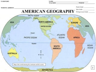
  • 1. US HISTORY NAME: ___________________________________________________ TEACHER: _________________________________ PERIOD: _______________ Packet Grade: _______________ WEBSITE ADDRESS: _______________________________________________________________ Quiz Grade: _________________ AMERICAN GEOGRAPHY Writing Lesson Grade: _________ Map of the world showing the continents and the oceans. 1 1
  • 2. UNIT STANDARDS AND OBJECTIVES: STANDARDS: NEW YORK STATE SOCIAL STUDIES STANDARDS: CCSS: Standard 3: Geography, Key Ideas 1 and 2 RH 7: 1, 2, 4, 6 RST 7: 1, 2, 4, 7 WHST 7: 1, 2, 4, 5, 7, 8, 9 UNIT OBJECTIVES: 1. Describe the relationships between people and environments and the connections between people and places. 2. Understand the geography of settlement patterns and the development of cultural patterns 3. Map information about people, places, and environments 4. Explain how maps provide information about people, places, and physical & cultural environments? 5. Discuss how geography affects how and where people live? 6. Understand key vocabulary terms such as: Environment, society, demographics, culture, geography, natural resources, weather, climate, latitude, and longitude. DAY: DAILY OBJECTIVES: 1 2 3 4 6 7 8 9 2
  • 3. Unit Engagement Activity: Directions: Read the information below, study the map, and answer the questions that follow Afraid of being lost at sea? Afraid of being eaten by a sea monster? Afraid of falling off the edge of the Earth? These are fears that early explorers had to deal with when they set sail and went beyond the sight of land. The reason they had to deal with these fears is because they had limited knowledge of world geography. How they used their limited knowledge has created the history that we have today. All human events are influenced by the environment that they take place in. Understanding Geography is important in order to understand the events of history. 1. Identify any errors or missing land forms you see on the map: _______________________________________________________________ _____________________________________________________________________________________________________________________ _____________________________________________________________________________________________________________________ 2. Predict how the errors or missing land forms could cause a problem and affect history: ____________________________________________ _____________________________________________________________________________________________________________________ 3 _____________________________________________________________________________________________________________________
  • 4. STUDENT NOTES: GEOGRAPHY OF THE AMERICA’S: *Understanding geography is important to our understanding of the past and present. -Geography is linked to _________________. -To understand history, you must understand _________________. -All of human history has taken place in and is influenced by the _____________________________ we live in. -The ____________________________ a person lives in affects the development of their culture. GEORGRAPHY: ____________________________________________________________________________ -Geography is the __________________________ in which we live and in which all past events have taken place. ENVIRONMENT: ____________________________________________________________________________ The Erie Canal was built in New York. To understand why it was built in its location, you need to understand geography. *Geography includes: 1. Physical/Geographic Features 4. Natural Resources 2. Weather 5. Human, Animal, & Plant Life Rivers are physical or geographic 3. Climate features and are examples of natural PHYSICAL FEATURES: (Geographical Features or Landforms) ____________________________________ resources. ____________________________________________________________________________________________ _ NATURAL RESOURCES: _____________________________________________________________________ WEATHER: _________________________________________________________________________________ CLIMATE: Quick Check Quiz #1: __________________________________________________________________________________ -Made up of temperature and precipitation (rain, snow, sleet, hail) 1._______ 3._______ Plants and animals are part of the geography and are examples of natural resources. Gold and trees are examples of 2._______ 4._______ natural resources. 4
  • 5. 5 THEMES OF GEOGRAPHY: To study and understand geography, we use the 5 Themes of Geography. 1. Location: Tells where a place is. A. Relative Location: Tells where a place is in relation to another place. B. Exact (Absolute) Location: Tells where a place is by using Latitude and Longitude lines on maps. LATITUDE: _________________________________________________________________________________________________________________________________ LONGITUDE: _______________________________________________________________________________________________________________________________ Lines of latitude run east and west and are located above and below the Equator. The Equator is the 0° latitude line. Lines of longitude run north and south North and are located left and right of the Prime Meridan. The Prime EQUATOR Meridan is the 0° longitude line. South When you take lines of latitude and lines of longitude and put them together, you get a map grid. West East PRIME 5 MERIDAN
  • 6. ● The United States is part of the continent of __________________ ______________________. 3 ● North America is one of the ___________ continents on the Earth. 1. _________________________ 5. _________________________ 1 5 2. _________________________ 6. _________________________ 4 3. _________________________ 7. _________________________ 2 6 4. _________________________ ●America’s location is in the ___________________ and _____________________ Hemisphere’s. North North 7 America America Rivers/Lakes Quick Check Quiz #2: Mountains 1._______ 3._______ 2._______ 4._______ Cities and buildings are man made so they are human features. 2. Place: Describes an area’s physical and human features. It is the environment in which we live. A. Physical Features: (Geographical Features or Landforms) B. Human Features: Houses, transportation, jobs, language, and religion. 6
  • 7. 3. Interaction Between People and Their Environment: People can clear land and plant crops, build houses, and build roads. A. People adapt to the _____________________________ by changing the way they live in order to survive. Ex: People change the types of clothes they wear when the weather changes. B. People can change the environment by physically changing the way it looks. Ex: People can cut down trees to build buildings, roads, or plant crops. -Everything that has happened in human history and everything that will happen, involves the physical environment. SUMMER WINTER In the 1600’s, the Pilgrims left England and migrated to the New World. They did not plan on going back. Mountain States Midwest 4. Movement: Movement of people, goods, and ideas. -People move in order to get resources. Northeast 5. Regions: An area with certain unifying characteristics. -Physical or human. West ●The United States is broken down into _________ general New York is in the Political/Social Regions. Northeast region of the US. The states in this 1. ___________________ 4. ___________________ region have similar features. Southeast 2. ___________________ 5. ___________________ Southwest 3. ___________________ 6. ___________________ 7
  • 8. MAPS: A representation of the features of the Earth or part of the Earth. 1. PARTS OF A MAP: All maps have 4 basic parts. A. ________________________________ C. ________________________________ B. ________________________________ D. ________________________________ 2. TYPES OF MAPS: There are 2 main types of maps; physical and political maps. PHYSICAL MAP: __________________________________________________________________ ___________________________________________________________________________________ POLITICAL MAP: _________________________________________________________________ ___________________________________________________________________________________ Quick Check Quiz #3: 1._______ 2._______ 3._______ 4._______ Political Map Physical Map 8
  • 9. WRITING LESSON #1: HOW TO WRITE A BASIC SENTENCE TO ANSWER A QUESTION In school, students are expected to be able to communicate effectively with their teachers. This communication includes writing answers to questions or tasks for class work and homework. These answers should be written out in complete sentences. Learning how to write a complete sentence is the first step in learning how to complete other types of writing assignments such as paragraphs and essays. Before writing an answer to a question, statement, or task, you must first study the task and understand what it is asking you to do. This means that you break down the task and look for important words (key words) that tell you what to do. By looking for and understanding the “key” word(s), you will have a better understanding of how to prepare a good answer. The “key” word in a task tells you what to do with the topic. Often the “key” word is an instruction word. Some common instruction words and their meanings are listed below. A Glossary of “Key” Words: Compare: To state the similarities between two or more examples. Contrast: To state the differences between two or more examples; to differentiate. Define: To explain what something is or what it means. Describe: To give details or features; to illustrate in words; to tell about. Discuss (Explain): To make observations using facts, reasoning, and argument; to present in some detail. Identify: To name in a sentence. List: To name in a list, not a sentence. When you are ready to write your sentence, you should begin by using the TTQA method to start your answer. The TTQA method is where you start your answer by “Turning The Question(Task) Around.” This means that you use the task to start your sentence. All answers must be written out in complete sentences. There are two exceptions to this rule. You do not have to write complete sentences if the task asks you to “list” your answer or if your answer is to be placed in a box or table. PRACTICE YOUR SKILLS: IDENTIFYING THE KEY WORD DIRECTIONS: Analyze each of the following tasks and then answer the questions that follow. Remember to use the TTQA method when starting your answer. 1. TASK: Define the term natural resource. A. What is the key word in the task? ______________________________________________________________________________________________________________ ____________________________________________________________________________________________________________________________________________ _ 9 B. What does the key word tell you to do? _________________________________________________________________________________________________________
  • 10. A. What is the key word in the task? _____________________________________________________________________________________________________________ ___________________________________________________________________________________________________________________________________________ B. What does the key word tell you to do? ________________________________________________________________________________________________________ ___________________________________________________________________________________________________________________________________________ _ 3. TASK: Describe how the environment of the Eastern Woodlands affected the way of life of the Iroquois. A. What is the key word in the task? _____________________________________________________________________________________________________________ ___________________________________________________________________________________________________________________________________________ _ B. What does the key word tell you to do? ________________________________________________________________________________________________________ ___________________________________________________________________________________________________________________________________________ PRACTICE YOUR SKILLS: WRITING SENTENCES USING TTQA _ DIRECTIONS: Answer each task by writing a complete sentence using the TTQA method. 1. Define the term environment. _________________________________________________________________________________________________________________ ____________________________________________________________________________________________________________________________________________ 2. Identify 2 physical features in New York State. ___________________________________________________________________________________________________ ____________________________________________________________________________________________________________________________________________ _ 3. List the 7 continents of the world. ______________________________________________________________________________________________________________ ____________________________________________________________________________________________________________________________________________ _ ____________________________________________________________________________________________________________________________________________ _ 10
  • 11. AMERICAN GEOGRAPHY: The study of American history often demands knowledge of American geography. From the arrival of the first Americans to the Battle of Saratoga during the American Revolution to the recent population shift to the Sunbelt States, geography has played a very important role in the development and history of the United States of America. WHAT IS GEOGRAPHY? Before understanding American history, you must first understand geography. Geography is the study of the physical, biological, and cultural features of the Earth’s surface. Geography deals with the environment in which we live. Our environment is the surroundings in which we live. This includes the landforms or geographic features or physical features of an area, the climate of an area, the temperature and weather of an area, natural resources, vegetation and soil, sources of water, and animal life. Natural resources are things found in nature that can be used to produce goods or services. Lumber, water, minerals, oil, and soil are examples of natural resources. Landforms, geographic features, and physical features are all the same thing. A landform (geographic feature/physical feature) is a feature of the earth’s surface. Another part of geography is the weather and climate of an area. Weather is the condition of the atmosphere in a given place at a given time. In other words, it is what it is doing outside right now. Climate is the average weather of an area over a period of 20-30 years. Understanding geography is important to the study of history because everything that has ever happened in the human past has happened in the environment. Everything that has happened in human history has been influenced by the geography of that specific area. This is known as “Interaction Between the Environment and Humans.” As a human, we can either change our environment or we change to fit into it. For example, if we need to build a new road and there is a forest in the way, what do we do? If the temperature is 10 degrees outside and we want to go out, what do we do? Sometimes, we can change our environment to suite our needs. Other times, we cannot. Then, we have to change the way we behave. STOP 1 ____________________________________________________________________________________________________________________________________________ _ AMERICA’S SIZE: The United States is a huge country on the North American continent. Not counting Alaska and Hawaii, the United States measures about 3,000 miles east to west and 1, 600 miles north to south. The Continental United States is bordered on the north by Canada, on the south by Mexico and the Gulf of Mexico, on the east by the Atlantic Ocean, and on the west by the Pacific Ocean. In size, the United States is the 4th largest nation in the world. More than 300 million Americans live on the more than 3.6 million square miles that our country covers. America’s size has had many effects on our history. For example, Americans are famous for inventing machines that allow fewer workers to do more work. One such invention was the mechanical reaper. The reaper made it possible for farmers to take full advantage of the vast areas in America available for planting. Also, the great size of America has led to many inventions for speedy and cheap transportation. The steamboat, faster trains, mass-produced cars, and airplanes are just a few examples. America’s size also partly explains our heritage as a country that has become home for people from all over the world. People have always wanted to come here, and there has always been plenty of room for them. STOP 2 ____________________________________________________________________________________________________________________________________________ _ 11
  • 12. AMERICA’S LAND AND WATER: Almost every landform, or physical feature, or geographic feature, is to be found somewhere in the United States. Physical features and geographic features are the same thing as landforms. These three words have the same meaning. A landform is a feature of the earth’s surface. Examples include bodies of water, mountains, valleys, deserts, and plains. Our rivers, lakes, and other bodies of water are essential parts of our country. They supply water for drinking and farming and, in some cases, for running power plants. They are also natural highways upon which enormous amounts of goods are moved every year. STOP 3 ____________________________________________________________________________________________________________________________________________ _ AMERICA’S LOCATION: The United States is in the Northern Hemisphere, the half of the earth north of the equator. The United States is also in the Western Hemisphere, the half of the earth west of Europe and Africa. The United States, along with Canada and Mexico, makes up North America. In addition, Central America and South America are part of the Western Hemisphere. Until about 500 years ago, mapmakers did not know that the Western Hemisphere existed. For thousands of years, the Atlantic and Pacific Oceans separated the Western Hemisphere from the ancient civilizations of Egypt, Greece, Rome, China, India, and Western Europe. Today, of course, ships and planes crisscross the oceans in a matter of hours or days, and the United States “faces” both east and west. It faces east towards Europe and Africa and faces west towards Asia. For much of their recorded history, however, the North and South American continents have “faced” east toward Europe. From about 1500 AD to 1800 AD, the European countries of England, France, Spain, and Portugal controlled much of the Western Hemisphere. Their effect on this hemisphere is still felt today. The United States began as a few small villages on the Atlantic Coast, settled mainly by English-speaking people. For the next 360 years or so, our country generally grew in a westerly direction – toward the Pacific Ocean, toward the setting sun, and toward Asia. This helps explain why our national capital, Washington, D.C., is closer to Great Britain than it is to Hawaii or the western shores of Alaska. In fact, Alaska and Hawaii are so far away from the rest of the country that they usually must be presented as insets on maps of the United States. STOP 4 ____________________________________________________________________________________________________________________________________________ _ REGIONS OF OUR COUNTRY: The United States has been broken down into regions by the Bureau of the Census. There are 6 basic regions in the United States. These include the Northeast, Southeast, Midwest, Southwest, Mountain States, and West. STOP 5 ____________________________________________________________________________________________________________________________________________ _ 12
  • 13. DIRECTIONS: Define the following terms by using the above reading and then answer the questions that follow. Remember to use the TTQA method when writing an answer. 1. STOP 1:Geography: _________________________________________________________________________________________________________________________ 2. STOP 1: Environment: _______________________________________________________________________________________________________________________ 3. STOP 1: Natural Resource: ____________________________________________________________________________________________________________________ 4. STOP 1: Landform/Physical Feature/Geographic Feature: ___________________________________________________________________________________________ 5. STOP 1: Weather: ___________________________________________________________________________________________________________________________ 6. STOP 1: Climate: ___________________________________________________________________________________________________________________________ 7. STOP 1: Why is understanding geography important to the study of history? ____________________________________________________________________________ ____________________________________________________________________________________________________________________________________________ _ 8. STOP 2: What countries make up the continent of North America? ____________________________________________________________________________________ ____________________________________________________________________________________________________________________________________________ _ 9. STOP 3: List examples of different landforms found in upstate New York. _____________________________________________________________________________ ____________________________________________________________________________________________________________________________________________ _ 10. STOP 4: The United States is located in which hemisphere(s)? ______________________________________________________________________________________ ____________________________________________________________________________________________________________________________________________ _ 11. STOP 5: How many regions are there in the United States? _________________________________________________________________________________________ 13 ____________________________________________________________________________________________________________________________________________ _
  • 14. MAP SKILLS WORKSHEET: THE PARTS OF A MAP DIRECTIONS: The map below provides information about the Yosemite National Park. Study the map and answer the questions. 1. What is the title of the map? _______________________________________________ _________________________________________________________________________ 2. Draw the pattern that is used to show the following information: a. Peak: c. State Highway: b. Pass: d. Camp: 3. What is the part of the map called that is used to find this information? _________________________________________________________________________ _________________________________________________________________________ 4. About how many miles is it from Tioga Pass to Tuolumne Meadows? _________________________________________________________________________ _________________________________________________________________________ 5. What is the part of the map called that you used to determine this distance? _________________________________________________________________________ _________________________________________________________________________ 6. In what direction would you be traveling if you started at Mono Pass and went to White Wolf Lodge? ________________________________________________________ ____________________________________________________________________________________________________________________________________________ _ 7. What part of the map is used to tell direction? _____________________________________________________________________________________________________ 14 ____________________________________________________________________________________________________________________________________________
  • 15. MAP EXERCISE: THE UNITED STATES IN THE WORLD DIRECTIONS: Use maps and additional references to complete the following. 1. Label the continents on the map by placing the letter of the continent in the correct area. a. North America c. Europe e. Asia g. Antarctica b. South America d. Africa f. Australia 2. Label the following lines on the map: Equator, Prime Meridian. 3. Label the following oceans: Pacific Ocean, Atlantic Ocean, Indian Ocean, and Arctic Ocean. 4. Label the compass rose on the map with the following directions: North, South, East, and West. 5. Label the United States of America, Mexico, and Canada on the map. 15 11
  • 16. AMERICAN GEOGRAPHY POWERPOINT PROJECT DIRECTIONS: Each group is to complete a PowerPoint program on a series of geographic features found in the United States of America. You are to research the geographic features shown below and create a PowerPoint program based on those features. Use the internet as your primary resource. PROJECT GUIDELINES (REQUIREMENTS): 1. TITLE SLIDE: You must have a title slide for the program. This title slide must have the following information: A. Name or title of the program/project. For example: “American Geography” (Times New Roman, size 40-44) B. Your names. (Times New Roman, size 24-28) C. Your class period. (Times New Roman, size 24-28) D. One or two images that relate to your title or topic. E. Each image must have its own caption. (Times New Roman, size 12-14) 2. BODY SLIDES: You must have 1 slide for each of the geographic features that you are working on. A. Your group must research the following geographic features. 1. Mountains 3. Rivers 2. Lakes 4. Plains B. You must include the following information on the body slides. 1. Every slide must have a title which gives the geographic feature that is discussed on the slide. Example: “Rivers of the United States” or “American Mountains.” (Times New Roman, size 40-44) 2. Under the slide title, you must give a definition of the geographic feature. Use www.dictionary.com for definitions. (Times New Roman, size 24-28) 3. You must have a map of the United States on each slide of the body. Then, research and find specific names of your geographic feature in the United States of America. Place the images of your feature on the slides and use arrows to show where it is located in the USA. The arrows should go from the images to the location on the map. 4. Each slide must have 2-4 images that explain/show/illustrate the geographic feature. Keep the slides “neat” and clean looking. 5. Each image must have a caption that explains or names the image. (Times New Roman, size 12-14) 3. END SLIDE: You must have an ending slide for the program. This end slide must have the following: “The End” (Times New Roman, size 96) 16
  • 17. PowerPoint Project Check Sheet: American Geography Project Name: ________________________________________ Period: ________________ Group Member Names: _________________________________________________________________ TITLE SLIDE: Title of Project: ________________________________________ REMEMBER: TITLE SLIDE: + /5 1. Font: Times New Roman 1. Do you have a title slide? Yes/No 2. Sizes of Font: 2. Do you have a title for the project on the slide? Yes/No A. Titles: 40-44 B. Text: 24-28 3. Do you have the names of the group members on the slide? Yes/No C. Captions: 12-14 4. Do you have your class period on the slide? Yes/No D. “The End”: 96 5. Do you have 1 or 2 images on the slide? Yes/No 3. Backgrounds: NONE BODY SLIDES: 6. Do you have a caption for each images on the slide? Yes/No 4. Animations: NONE 7. Did you use the proper font style and size? Yes/No 5. Slide Transitions: NONE BODY SLIDES: + /20 1. Do you have 4 slides in the body of the program? Yes/No 6. Keep the slide neat. 2. Do you have a title for each slide? Yes/No 7. Use up empty or “dead” 3. Do you have the definition of the geographic feature on each slide? Yes/No space with more information or images. 4. Do the images relate to the feature on the slide? Yes/No END SLIDE: 5. Do you have a caption for each image on each slide? Yes/No 8. If you need to, split up information onto more than 1 6. Do you have 2-4 images on each slide? Yes/No slide. 7. Did you use the proper font style and size? Yes/No END SLIDE: + /5 / 30 = 1. Do you have a slide that says “The End”? 17 Yes/No 2. Did you use the proper font style and size? Yes/No
  • 18. AMERICAN GEOGRAPHY TEST REVIEW SHEET: DIRECTIONS: Complete the following review sheet to help prepare for the unit test. PART 1: VOCABULARY: Write out the definitions for the following terms. 1. GEOGRAPHY: _____________________________________________________________________________________________________________________________ 2. LATITUDE: _______________________________________________________________________________________________________________________________ 3. LONGITUDE: _____________________________________________________________________________________________________________________________ 4. PHYSICAL FEATURES: ____________________________________________________________________________________________________________________ 5. NATURAL RESOURCES: ___________________________________________________________________________________________________________________ 6. CLIMATE: ________________________________________________________________________________________________________________________________ 7. WEATHER: _______________________________________________________________________________________________________________________________ 8. ENVIRONMENT: __________________________________________________________________________________________________________________________ PART 2: SHORT ANSWER: Answer the following questions to help understand the ideas and concepts covered in this unit. 1. How are history and geography related to each other? ______________________________________________________________________________________________ ____________________________________________________________________________________________________________________________________________ _ 2. What type of location do lines of latitude and longitude show? ________________________________________________________________________________________ 3. Explain the theme called “Interaction Between People and Their Environment.” __________________________________________________________________________ ____________________________________________________________________________________________________________________________________________ _ 18 4. What are some other names for physical features?
  • 19. _______________________________________________________________________________________ _______________________________________________________________________________________ _______________________________________________________________________________________ _______________________________________________________________________________________ _______________________________________________________________________________________ _______________________________________________________________________________________ _______________________________________________________________________________________ _______________________________________________________________________________________ _______________________________________________________________________________________ _______________________________________________________________________________________ _______________________________________________________________________________________ _______________________________________________________________________________________ _______________________________________________________________________________________ _______________________________________________________________________________________ _______________________________________________________________________________________ _______________________________________________________________________________________ _______________________________________________________________________________________ _______________________________________________________________________________________ _______________________________________________________________________________________ _______________________________________________________________________________________ _______________________________________________________________________________________ _______________________________________________________________________________________ _______________________________________________________________________________________ _______________________________________________________________________________________ _______________________________________________________________________________________ _______________________________________________________________________________________ 19 _______________________________________________________________________________________ ___________________________
  • 20. _______________________________________________________________________________________ _______________________________________________________________________________________ _______________________________________________________________________________________ _______________________________________________________________________________________ _______________________________________________________________________________________ _______________________________________________________________________________________ _______________________________________________________________________________________ _______________________________________________________________________________________ _______________________________________________________________________________________ _______________________________________________________________________________________ _______________________________________________________________________________________ _______________________________________________________________________________________ _______________________________________________________________________________________ _______________________________________________________________________________________ _______________________________________________________________________________________ _______________________________________________________________________________________ _______________________________________________________________________________________ _______________________________________________________________________________________ _______________________________________________________________________________________ _______________________________________________________________________________________ _______________________________________________________________________________________ _______________________________________________________________________________________ _______________________________________________________________________________________ _______________________________________________________________________________________ _______________________________________________________________________________________ _______________________________________________________________________________________ 20 _______________________________________________________________________________________ ___________________________
  • 21. LATITUDE AND LONGITUDE: A. LINES OF LATITUDE: B. LINES OF LONGITUDE: C. GLOBAL GRID: LATITUDE AND LONGITUDE 21
  • 22. LATITUDE AND LONGITUDE: Imagine that you are the captain of a U.S. aircraft carrier in the Persian Gulf. You get a message that an unidentified fighter plane is headed your way. The plane’s current location is 28°N latitude, 50°E longitude. Where is the plane? You would know if you understood latitude and longitude. Mapmakers long ago came up with this system of crisscrossing lines to locate places on maps and globes. Latitude: North-South Distance Globe A shows a series of lines circling Earth. The lines, called parallels of Latitude, measure distance north and south of the equator. Any place on the equator is 0° latitude. Latitude increases as you travel north or south to a maximum of 90° at each pole. Any location north of the equator is north latitude (N); any place south of the equator is south latitude (S). Longitude: East-West Distance Globe B shows a series of lines running from pole to pole. These are meridians of longitude. They measure distance east or west of the prime meridian, an imaginary line running from pole to pole through Greenwich, England. Any point on the prime meridian is 0°. Longitude increases as you travel east (E) or west (W) until you reach 180°. The 180° meridian is in the Pacific Ocean, halfway around the globe from the prime meridian. Global Grid: Latitude and Longitude Globe C shows latitude and longitude combined to form a global grid. Latitude is listed first, then longitude. For example: Aden is 15°N, 45°E. DIRECTIONS: Answer the following questions using the globes and reading. 1. What is the name for 0° latitude line? ___________________________________________________________________________________________________________ 2. What is the name for 0° longitude line? _________________________________________________________________________________________________________ 3. To measure distance north and south of the equator, you would use lines of _____________________________________________________________________________ 4. To measure distance east and west of the Prime Meridian, you would use lines of _______________________________________________________________________ 5. If you were at 15°S, 45°W, on which continent would you be? _______________________________________________________________________________________ 6. Look at Globe C. What city is located at 15°N, 45°E? ______________________________________________________________________________________________ 22 7. Look at Globe C. What city is located at 60°N, 23°E? ______________________________________________________________________________________________
  • 23. HEMISPHERES: WHERE ARE YOU? Where do you live? a. Western Hemisphere? b. Eastern Hemisphere? c. Northern Hemisphere? d. Southern hemisphere? Stumped? Geographers divide the globe into hemispheres to locate places more easily. (Hemi means half; sphere means globe.) Here's how the world is divided. 1. Northern/Southern: We can also split the globe in half along the equator. The equator circles the Earth halfway between the North and South poles. The Northern Hemisphere includes everything north of the equator; the Southern Hemisphere includes everything south of the equator. 23 13
  • 24. 2. Western/Eastern: We can divide the globe in half from the North Pole to the South Pole, giving us a Western Hemisphere and an Eastern Hemisphere. Geographers usually divide the globe at 20°W and l60°E so that most continents fall into either one of these two hemispheres. DIRECTIONS: Answer the following questions based on the globes and reading. 1. A line from the North Pole to the South Pole divides Earth into the ________________________ Hemisphere and _______________________ Hemisphere. 2. Both North and South America are in the _______________________________ Hemisphere. 3. Both Africa and Europe are in the ______________________________ Hemisphere. 4. The equator divides the globe into the __________________________________ and _________________________________ hemispheres. 5. People in the U.S. live in the _____________________________ and _______________________________ hemispheres. 24
  • 25. 25