1. Available online http:/amq.aiqua.it
ISSN (print): 2279-7327, ISSN (online): 2279-7335
Alpine and Mediterranean Quaternary, 26 (1), 2013, 15-29
ENVIRONMENTAL CHANGES IN THE BOIANO INTRAMONTANE BASIN (MOLISE,
ITALY) SINCE THE TIMES OF ANCIENT BOVIANUM (IVTH CENTURY BC)
Vincenzo Amato1
, Pietro P.C. Aucelli2
, Andrea Capozzi3
, Gianfranco De Benedittis4
,
Gerardo Pappone2
, Carmen M. Rosskopf1
1
GeoGisLab, Dipartimento di Bioscienze e Territorio, Università degli Studi del Molise, C.da F. Lappone, Pesche (IS), Italy
2
DiSAm, Università degli Studi di Napoli “Parthenope”, Napoli, Italy
3
Seconda Università di Napoli, Maria Capua Vetere (CE), Italy
4
Dipartimento di Scienze Umanistiche, Sociali e della Formazione, Università degli Studi del Molise, Campobasso, Italy
Corresponding author: Vincenzo Amato <vincenzo.amato@unimol.it>
ABSTRACT: The ancient Samnitic and Roman towns of Bovianum, located at the base of the northern slope of the Matese Mountains and
partially extending within one of the most depressed sectors of the Boiano intramontane basin, were strongly influenced by historical pal-
aeoenvironmental changes mainly due to climatic and man-induced variations and subordinately to the effects of historical seismicity. The-
se changes influenced the evolution in time of the urban settlement layout extensions, which shifted alternatively towards the Matese slope
and its piedmont area and the plain. In particular the Samnitic-Roman Municipium (IV century B.C.-I century A.C.) was located mainly with-
in the piedmont area and only partially within the plain, while other smaller settlements were founded at the top of the palaeosurfaces of
Mt. Crocella and Civita. From the I to the IV century A.C., the Roman Colonia expanded both towards the plain and the slope, thanks to the
reclamation of the most depressed sectors of the plain, as well as to slope terracing and buildings, respectively. After the IV century A.C.
and up until the XIX-XX century AD, the plain sector was gradually abandoned, while the urban areas were mainly concentrated at the top
of the Civita paleosurface and within the piedmont area. Within the last two centuries the plain was newly occupied, conversely the Civita
settlement was gradually abandoned. With the intent of investigating the main palaeoenvironmental changes and their causes, an integrat-
ed multidisciplinary analysis of the morpho-stratigraphical and historical-archaeological data was carried out. Facies analyses of two core
successions, retrieved from the central area of the modern village of Boiano, and a critical review of archaeostratigraphical records of older
archaeological excavations, allowed for the identification of 10 archaeostratigraphical units. The sedimentary succession intercepted by the
core located at the base of the piedmont area base of the Matese slope was made up of alternating layers of paleosols, debris cone de-
posits and man-induced fills, the succession coming from the core located in the plain sector, instead, by alternating layers of paleosols
and fluvial marshy-deposits. The tephro-stratigraphic data allowed to chronologically constrain the uppermost 7 to 9 m thick portion of the
Boiano filling (named Boiano upper fill) to the Later Upper Pleistocene-Holocene. Archaeological data from older excavations and the ar-
chaeological remains included in the core successions then allowed to date most of the aggradation and waterlogging phases recognized
in the piedmont area and plain sector, respectively. At least three debris cone deposition phases could be recognized which are chronolog-
ically constrained prior to the IV century A.C., between the IV century A.C. and the Middle Age and between the XVI and XIX centuries AD,
respectively, and can be most likely correlated with the well documented periods of climatic deterioration known as the Iron Age, the Dark
Age (IV-IX centuries AD) and the Little Ice Age (XVI-XIX centuries AD), respectively. Likewise debris deposition, as well as waterlogging
affected the plain mainly during the above mentioned periods and can be certainly -at least partially -attributed to the mentioned periods of
climate deterioration characterized by increased rainfalls and consequent rising of the ground water level. Waterlogging events, however
but could have been favored also by tectonic subsidence, caused by the earthquakes which affected the Boiano area during the III-II cen-
tury B.C. and in 853, 1456 and 1805 AD.
Keywords: Geoarchaeology, Archaeostratigraphy, Historical environmental changes, Climatic controls, Molise.
1. INTRODUCTION
The role of climatic changes and human actions in
shaping the Mediterranean landscapes has been
strongly debated as of the study carried out by Vita Finzi
(1969) on the Holocene evolution of Mediterranean val-
leys. He argued that climatic changes were the main
control factors for the major phases of Holocene alluvia-
tion and related palaeoenvironmental changes. The flu-
vial succession which laid down during the most im-
portant period of Late Holocene alluvial aggradation is
generally known as Younger Fill and dates back to a
time period that spans from the Classical age (2.5 ka
BP) to the end of the Late Antiquity Age (1.3 ka BP) (Vi-
ta Finzi, 1969). During this period most of the Classical
to Late Roman settlements and towns in the Mediterra-
nean were affected by several phases of alluviation
which were frequent cause of their destruction or partial
burial and the consequent need to rebuild or relocate
elsewhere (Pope & van Andel, 1984; Ortolani & Pagliu-
ca, 1994; Giraudi, 1995; Allocca et al., 2000; Ortolani &
Pagliuca, 2003; Pope et al., 2003; Wilkinson & Pope,
2003; Giraudi, 2005; Amato, 2006; Giraudi et al., 2007).
A last important period of alluvial aggradation affected
the Mediterranean valleys from the 16th
to the 19th
cen-
tury AD-during the Little Ice Age (Lamb, 1995; Baroni &
Orombelli, 1996; Orombelli & Ravazzi, 1996; Bond et
al., 2001; Cronin et al., 2003; Mann, 2003; Mayewski et
al., 2004; Rosskopf et al., 2006; Giraudi et al., 2007).
During these two periods, within the low-lying
2. Amato V. et al.
16
zones of the intramontane basins of the Apennine chain,
the rise of underground water level led to the formation
and expansion of marshy and lake environments (Gi-
raudi, 1989; Berglund et al., 1996; Zolitschka et al.,
2000; Giraudi, 2004; Roberts et al., 2008; Magny et al.,
2011; Magny et al., 2012), while shorelines, especially
those including major river mouths, registered a strong
progradation (Aucelli & Rosskopf, 2000; Aucelli et al.,
2011; Pappone et al., 2011; Amato et al., 2013; Ros-
skopf & Scorpio, 2013). Based on other studies (Pope &
van Andel, 1984; Messerli et al., 2000; Amato et al.,
2010b) the above mentioned changes could have been
caused by human impact on the environment due to de-
forestation, cultivation and pasture purposes or, simply,
overgrazing. Finally, according to other authors (see
Barker et al., 1978; Bintliff, 1982; de Menocal, 2001;
Barker & Hunt, 2003; Berglund, 2003; Amato, 2006;
Hunt, 2006), land use changes could have contributed
to such environmental changes; however, climatic
changes are thought to be the most likely primary con-
trol factor. One of the zones of the Mediterranean area
that provide a better record of the possible relationships
between human actions and environmental changes are
the intramontane basins. Their infillings frequently give
good evidence of depositional or even erosional events
and are often consistent in archaeological remains. This
permits integration of geomorphologic, stratigraphic and
palaeoenvironmental records with archaeological and
historical data. Therefore, it allows identifying and
chronologically constraining the possible influence of
climate changes and human actions on Mediterranean
landscape evolution, while assessing related possible
cause-effect relationship. To improve our knowledge
concerning the processes and causes responsible for
recent environmental changes, we carried out an inte-
grated study on the Boiano basin, named after the major
village of Boiano therewith located in the central sector
of the basin at the base of the northern slope of the Ma-
tese Mountains (Fig. 1). The modern village buried ar-
chaeological layers of Samnitic to Roman age (referring
to the ancient Bovianum) and Middle Age to Modern
age. These archeological layers are object of recent and
current archaeological research (see Ceglia, 2005b; De
Benedittis et al., 2008) focusing especially on the devel-
opment and extension of Bovianum in historical times,
without considering palaeoenvironmental and climatic
perspectives.
In order to assess historical environmental chang-
es which have affected Bovianum in time and, especial-
ly, the influence of climatic changes, historical seismicity
and human activities, our study focuses on the archaeo-
stratigraphic and facies analysis of the uppermost, ca.
10 m thick, part of the Boiano basin infilling, which
makes up the substratum of the Boiano urban area and
surroundings. The latter was investigated by means of
two recently drilled core successions (see below) and
the sedimentary successions intercepted by some small
artificial trenches and archaeological excavations.
2. GEOLOGICAL AND GEOMORPHOLOGICAL SET-
TING
The Italian Apennine chain (Fig. 1B) hosts several
intramontane basins mainly located along its axial zone
and generally NW-SE and NE-SW oriented. These ba-
sins started to form during the compressional phase of
Plio-Quaternary tectonics (Corrado et al., 2000; Patacca
& Scandone, 2007; Amato et al., 2011) and subsequent-
ly evolved under the control of extensional tectonics,
which has been active at least since the Middle Pleisto-
cene (Corrado et al., 1997; Di Bucci et al., 2002; Di
Bucci et al., 2005; Amato et al., 2011). From a structural
perspective, these basins can be defined as tectonic
depressions (graben or semi-graben), bordered and in-
tersected by strike-slip and normal faults (Corrado et al.,
2000; Galli & Galadini, 2003; Di Bucci et al., 2005; Ama-
to et al., 2011). These faults are in part still active and
responsible for the historical seismicity and for the over-
all or partial subsidence of the basins (Galli et al., 2002;
Galli & Galadini, 2003; CPTI, 2004; Galadini & Galli,
2004, Amato et al., 2012).
From a geomorphological perspective, these ba-
sins are characterized by flat alluvial plains, many of
which have been drained thanks to land reclamation
interventions (Chouquer et al., 1987; Giraudi, 1989;
Barker & Hunt, 2003; Giraudi, 2004). The plains are
generally located within a mountainous to hilly land-
scape and are characterized by border slopes whose
piedmont areas have undergone huge and widespread
aggradation over time, mainly due to alluvial fan deposi-
tion and the formation of colluvial, scree talus and
cones.
The Boiano basin is one of the major intramontane
tectonic basins of the Molise sector in the Apennine
chain. These basins are located within a narrow NW-SE
elongated deformation belt, extending for ca. 40 km be-
tween the Isernia and Sepino plains (Fig. 1C), and are
filled with thick Quaternary successions of marshy to
lacustrine, volcaniclastic and alluvial deposits (Russo &
Terribile, 1995; Brancaccio et al., 2000; Di Bucci et al.,
2002, 2005; Coltorti et al., 2005; Aucelli et al., 2011;
Amato et al., 2012; Orain et al., 2012).
The geological evolution of these basins has been
strongly controlled by extensional fault systems since
the Middle Pleistocene (Corrado et al., 2000; Di Bucci et
al., 2002; Di Bucci et al., 2005; Patacca & Scandone,
2007; Amato et al., 2011), some segments of which are
currently active (Valensise & Pantosti, 2001; Galli et al.,
2002; Galadini & Galli, 2004) and responsible for the
main earthquakes recorded in the Molise Apennine
(Galli & Galadini, 2003; CPTI, 2004).
The Boiano basin is located at ca. 500 m a.s.l. be-
tween the Matese and Montagnola di Frosolone car-
bonate massifs and the siliciclastic Sannio hills (Fig.
1C). It is ca. 4 km large and elongated for ca. 20 km in
the NW-SE direction, and is drained by the Biferno River
that flows to the Adriatic Sea (Rosskopf & Scorpio,
2013).
The modern urban area of Boiano is located at el-
evations of 480-500 m a.s.l. in one of the most low-lying
sectors of the basin, while remnants of more ancient
settlements are located on the Matese slope and along
its piedmont area, at elevations between 500 and 1000
m a.s.l. (Fig. 2).
The Matese slope is characterized by a step of flat
surfaces, located at elevations between 1400 and 700
m a.s.l. These surfaces are interpreted as palaeosur-
faces, i.e. remnants of gently-rolling ancient landscapes,
mostly carved in bedrock and now hanging at different
3. The Boiano basin since the times of ancient Bovianum 17
altitudes above the local base-levels of erosion (Aucelli
et al., 2010; Aucelli et al., 2011). Their genesis is related
either to prolonged periods of relative tectonic stability
alternating with periods of uplift, or partially even to the
interplay between steady tectonic uplift and climatic fluc-
tuations (Aucelli et al., 2011). On top of the Civita and
Mt. Crocella palaeosurfaces (Fig. 2), located at ca.750
m and 1000 m a.s.l., respectively, important archaeolog-
ical remnants of Samnitic to Middle Age Age (see be-
low) have been discovered.
The palaeosurfaces are connected to the plain by
steep structural slopes, generated by high-angle faults
which were active during the Quaternary and responsi-
ble for the disarticulation of the northern front of the Ma-
tese massif. The WNW-ESE trending master fault is lo-
cated at the base of the slope which borders the basin
southwards and crosses the SW sector of the urban ar-
ea of Boiano.
In addition to extensive tectonics, climatic changes
have also contributed to the Quaternary evolution of the
slopes bordering Boiano to the SW. During glacial peri-
ods and especially during the last one, carbonate slopes
were affected by widespread slope replacement, ac-
cording to the rectilinear-parallel slope recession model
(Young, 1972; Brancaccio et al., 1979; Amato et al.,
2010a) and the formation of thick aggradational foot
Fig. 1 - A) The structural sketch map of Italy and location of the study area; B ) Digital elevation model of the sector of the Apennine
chain including the Boiano basin; C) Geologic sketch map derived from sheet 405 (Campobasso) of the new geological map of Italy at
scale 1:50,000 (CARG Project, Geological Survey of Italy, ISPRA). 1: continental sediments and volcaniclastic deposits (Late Pleisto-
cene-Holocene); 2: foredeep and piggy-back siliciclastic deposits (Miocene); 3: clays, marls and limestones (Sannio Unit, Upper Creta-
ceous-Miocene); 4: clays, marls and limestones (Molise pelagic successions, Oligocene-Miocene). 5: limestones, dolomites and marls of
carbonate platform (a) and slope facies (b) (Triassic-Miocene); 6: main thrusts; 7: main extensional faults, dashed when inferred.
4. Amato V. et al.
18
slopes. The latter are made of two generations of scree
deposits: the lower one, generally well cemented and
with openwork texture, and the upper one, generally
loose and matrix supported. The latter can be dated
most likely to a period that spans from the Last Glacial
Maximum to the Holocene (Pappone et al., 2012), as it
contains the Neapolitan Yellow Tuff tephra dated to 15
ka BP (Deino et al., 2004).
The Matese front in the Boiano area is dissected
by some gully incisions, which have contributed to build
small debris cones along the southern border of the ba-
sin, and some of these extend to the Boiano urban area
(Fig. 2). Several springs feed minor watercourses and
are partially captured for drinking water distribution.are
situated at the base of the border slope. Major water-
courses coming from the border slopes have generated
gentle alluvial fans extending partially within the plain
(Fig. 2). As the urban center of Boiano is located within
one of the most low-lying areas of the plain, it has a very
shallow groundwater level and, therefore, is poorly
drained. Surface waters coming from the mountain
slope are mainly drained by the Calderari stream -which
is also partially fed by the outflows of the Maiella springs
and crosses directly the urban area- and by the Spin
channel which is most likely of anthropogenic origins
and derives part of the waters in the Calderari stream
(Fig. 3). Finally, the SE sector of the Boiano village is
drained by the Biferno River which takes its origins from
the Biferno springs (H in figure 3) and receives the wa-
ters of the Calderari stream.
Two recently drilled boreholes in the urban center
of Boiano allowed to investigate the Boiano fill succes-
sion up to a depth of 160 m (Amato et al., 2012; Orain et
al., 2012; Pappone et al., 2012). The two boreholes S1
and B6 (Figs. 2 and 3), 160 m and 73 m deep, respec-
tively, are located at ca. 100 m from each other and at
482 m and 484 m a.s.l., respectively, with the B6 core
being located closer to the border slope of the plain.
Fig. 2 - Geological-geomorphologic sketch map of the south-eastern sector of the Boiano basin including the village of Boiano. A: loca-
tion of the S. Erasmo-S. Chiara church archaeological excavations, B: location of the Calderari archaeological area.
5. The Boiano basin since the times of ancient Bovianum 19
A detailed stratigraphic and facies analysis was per-
formed on the core successions and the most significant
levels were investigated by means of tephrostratigraphy,
palinology and 40
Ar/39
Ar radiometric dating (Aucelli et al.,
2011; Amato et al., 2012; Orain et al., 2012; Pappone et
al., 2012). The investigated part of the Boiano basin infil-
ling reaches the Middle Pleistocene (Marine Isotopic
Stage 13, i.e. MIS13) and is made of three units: a Lower
Unit of lacustrine-palustrine origin, chronologically con-
strained between the MIS 13 and the MIS 10 (500 ka BP-
350 ka BP), a Middle Unit of fluvial-marshy origin, con-
strained between the MIS 10 and the MIS 9 (350 ka BP-
250 ka BP) and an Upper Unit made of fluvial-marshy
sediments and Late Pleistocene to Holocene in age (Bo-
iano Synthem, according to Pappone et al., 2012).
Thanks to the presence of the Neapolitan Yellow Tuff lay-
er (15 ka BP, Deino et al., 2004,) the Boiano Synthem
could be divided into two sub-units that are Late Pleisto-
cene and Late Glacial to Holocene in age, respectively. A
comparison of the two borehole successions allowed
identifying a high angle, NW-SE oriented fault which
passes between the two boreholes and crosses the urban
center of Boiano (Fig. 2). This fault has been active at
least during the Middle Pleistocene, as evidenced by the
vertical displacement of the correlated Ar/Ar dated tephra
layers recognized in both cores (Amato et al., 2012). In-
stead, it is not clear if it has been active also during Late
Pleistocene and Holocene and whether it is currently ac-
tive. The documented high historical seismicity of the Bo-
iano area may support this hypothesis. At least seven his-
torical earthquakes occurred in 346, 848, 1293, 1315,
1349, 1456 and 1805 AD, are documented (CPTI, 2004).
At least the ones occurred in 346, 848, 1456 and 1805
AD caused damages in several villages located within the
Boiano and Sepino basins (Pescatore et al., 2004; De
Benedittis, 2012). In addition, Galadini et al. (2002), Galli
& Galadini (2003) and Galadini & Galli (2004) identified
an earthquake which is chronologically constrained be-
tween the III and II century B.C. and which damaged the
Ercole-Quirino Sanctuary of Campochiaro, located circa 3
km SE of Boiano.
3. MATERIAL AND METHODS
In order to improve the currently available data on
chronology and stratigraphy of the younger part of the
Boiano infilling as well as on the recent palaeoenviron-
mental evolution of the basin, we investigated in detail
its uppermost portion matching it to the above-
mentioned Late Glacial-Holocene sub-unit. This sub-
unit, 7 m and 9 m thick in the B6 and S1 cores, respec-
tively, is mainly made of alternating fluvial, debris slope
and palustrine deposits, and is characterized by several
unconformities and soils and is partially rich in archaeo-
logical remnants. In particular, we analyzed this sub-unit
in order to define color, texture, grain features (size,
shape, composition), fossil content, sedimentary and
diagenetic structures, according to the methods illus-
trated in Tucker (2011). On the basis of lithofacies, un-
conformities and soils, the two core successions were
subdivided into stratigraphic units (US, sensu Tucker,
2011). According to the Soil Survey Staff classification
(2010) concerning soils formed in aggradational and,
typically, in archaeological contexts (Cremaschi, 2000),
we defined the soils as buried soils and, in accordance
with Daniels (2003), as multiple soils. In cases in which
such buried soils were only made of very thin pedogenic
horizons developed on their parent materials, they have
been defined as buried pedogenetic horizons, according
to the Soil Survey Staff classification (2010).
Our palaeoenvironmental interpretations are
based on the sedimentary features of the distinguished
stratigraphic units and the collected historical and ar-
chaeo-stratigraphic data. With reference to the latter,
first of all the archaeological content of the two cores
has been analyzed from a chronologic and taxonomic
perspective in order to detail the chronology of the units
and the relative palaeoenvironemental changes. Subse-
quently the archaeo-stratigraphical data coming from
the archaeological excavations of S. Erasmo -S. Chiara
church and the archaeological area following part of the
Calderari stream (hereinafter Calderari archaeological
area) (Ceglia, 2005b; De Benedittis, 2012), were ana-
lyzed. Furthermore, we performed a critical revision of
the literature dealing with historical and/or archaeologi-
cal aspects of the Boiano territory paying particular at-
tention to historical sources and epigraphs dealing with
the impacts of natural or man-induced changes follow-
ing earthquakes, flood events, waterlogging and land
reclamation. The interpretation of collected archaeo-
stratigraphical data was supported by a detailed geo-
morphological analysis of the territory of Boiano by
means of cartographic analysis of 1:5,000 topographic
sheets and field surveys.
4. RESULTS
4.1. Archaeological data
While the most ancient settlements discovered in
the Boiano basin are ascribed to the Iron Age (Capini,
1980; Ceglia, 2005a; De Benedittis, 2005), the most an-
cient ones found within and around the modern village
of Boiano are Samnitic in age and date to the IV century
B.C. They include important defensive wall systems in
polygonal work forming three separate structures (Fig.
3): a first small and circle-like wall structure is located at
circa 1000 m a.s.l., on top of the Mt. Crocella palaeosur-
face (De Benedittis, 1995); a second one is found on top
of the Civita palaeosurface (750 m a.s.l., figures 2 and
3) where the discovery of several black-painted pottery
findings allowed to testifying the presence of a perma-
nent settlement that stretched over the entire Civita sur-
face (De Benedittis, 1977); a third, rectangular wall
structure, much larger than the other two, extends within
the piedmont area of Boiano village and the sector of
the plain immediately in front of it and contributes to de-
fine the boundaries of the Samnitic Bovianum (Fig. 3).
The northern boundary of Bovianum is evidenced
by wall remains which are located in the Largo Gentile
and Palazzo Quaranta subsoil (C and D respectively in
Fig. 3) (De Benedittis, 1995; De Benedittis et al., 2008),
while the southern boundary can be located at the
height of the S. Michele Arcangelo Church (550 m a.s.l.,
E in Fig. 3) (De Benedittis, 1977). The eastern boundary
coincides with the part of the wall structure discovered
near the S. Biase Church (F in Fig. 3). Finally, the west-
ern boundary of Bovianum is evidenced by the most im
portant Samnitic wall remains discovered in the Boiano
6. Amato V. et al.
20
area up to now: ca. 15 m long, these wall remains have
been unveiled during the archaeological excavation (De
Benedittis, 1995; De Benedittis, 2004) carried out within
the Episcopio of S. Erasmo (A in Fig. 3). The western
boundary of the Samnitic settlement could have been
influenced by the presence of the little stream which en-
ters the plain immediately to its west, while the eastern
boundary may have depended on the presence of the
low lying sector of the Biferno springs (H in Fig. 3). In
fact, in this way, the Samnitic settlement was partially
built on the piedmont area and partially on the plain but
without including its very low lying sectors.
This settlement layout of Bovianum certainly per-
sisted up until the end of the II century B.C., as recorded
by historical sources (Appiano, Bellum Civile, I, 51) that
mention the presence of the three wall systems. During
this period Bovianum was an important center and well
connected to the main commercial and economical
roads crossing the Apennine chain and directed towards
the Tyrrhenian and Adriatic coasts. Bovianum was often
mentioned in the writings of Livio on the three Samnitic
Wars (343-341 B.C., 326-304 B.C., 298-290 B.C.),
when the Romans conquered the Samnitic Bovianum
without losing its importance (De Benedittis et al., 2008).
The situation changed after the Social War when Bovia-
num lost its political and cultural autonomy as men-
tioned by historical sources describing the Sannio re-
gion as almost uninhabited and its settlements and
towns as partially destroyed (Strabone V, 4, 11; Floro,
Epit., I, 16, 7-8). Between the I century B.C. and the I
century AD, the ancient Bovianum became first a Ro-
man Municipium (48-46 B.C.), then a Colonia Triunvirale
Lege Iulia (44-27 B.C.) (Lib. Col. 231, 259 L) and, final-
ly, a Colonia Flavia (73-75 AD) (La Regina 1966, De
Benedittis 1977, 1995). During this period the historical
sources mention two colonies, named Boianum Vetus
and Boianum Undecumanorum (Plinio, N. H., III, 107),
which could have represented the same settlement with
two chronologically different urban layouts (De Benedit-
tis, 2004; De Benedittis et al., 2008). The Republican
age settlement (I century B.C-I century AD) seems to
have the same urban layout of the Samnitic settlement.
Several archaeological data allow to hypothesize the
presence of the urban area extending up to the slope of
Civita, with the buildings located on artificial terraces
(De Benedittis, 1995; De Benedittis, 2004), and its
abandonment during the I century AD. In fact, the ar-
chaeological excavations in the S. Erasmo area (A in
fig. 3) highlight that 2 m-thick debris cone deposits cov-
ered the Samnitic-Roman walls (De Benedittis 2004; De
Benedittis, 2012). Consequently, in the years from 73 to
75 AD, the Vespasian Emperor defined a new urban
layout in which the urban area extended within the plain
(De Benedittis, 1977; De Benedittis, 2004), while the low
lying area of the plain was reclaimed and geometrically
divided (Centuratio) in order to distribute the lands to the
XI Legion Veterans (Chouquer et al., 1987; De Benedit-
tis, 2004). Archaeological data related to this second
Fig. 3 - Digital Elevation Model of the Boiano area and location of the B6 and S1 cores (green circles) and the archaeological sites (A-I,
red circles) mentioned in the text. A: S. Erasmo-S. Chiara Church; B: Calderari archaeological area; C: Largo Gentile; D: Palazzo
Quaranta; E: S. Michele Arcangelo Church; F: S. Biase Church; G: S. Bartolomeo Church; H: Biferno springs; I: Maiella spring. The red
lines and the red circle represent the remnants of the Samnitic walls structures located on the piedmont area and on the Civita pal-
aeosurface, respectively. The third Samnitic wall structure, which is located on the Mt. Crocella palaeosurface (ca. 1000 m a.s.l.), is out-
side the figure. The yellow dotted grid represents the layout hypothesis of Roman Colonia age (I-IV centuries AD).
7. The Boiano basin since the times of ancient Bovianum 21
urban layout have been discovered in the
Calderari archaeological area (B in fig. 3):
here a paved Roman road (I century AD) ap-
peared at ca. 3.5 m of depth. Considering the
width of this road (9.50-9.90 m) it can most
likely be identified with the Decumanus Max-
imum of the settlement (Chouquer et al,
1987; De Benedittis, 2004; De Benedittis et
al., 2008). In addition, several archaeological
data allow to suppose that the Calderari area
was the center (Forum?) of the ancient village
(De Benedittis et al., 2008) and the Decuma-
nus Maximus was the urban area thourough-
fare (De Benedittis, 1977; De Benedittis,
1998). If this interpretation is correct, the
northern boundary of the Colonia can be ex-
tended north to the location of the S1 core
(Fig. 3).
Until the Late Roman Imperial period
(IV century AD), the urban layout remained
unchanged (De Benedittis, 1977; 2004). An
epigraph, dedicated to Fabio Massimo, rector
Provinciae Samnii from 353 to 357 AD, men-
tions the reconstruction of the Secretarium
(De Benedittis, 1977; 1995). This document
has given rise to the hypothesis that Bovia-
num had been strongly damaged by the 346
AD earthquake (Camodeca, 1971; Russi,
1971; Buonocore, 1992; Galadini et al., 2002;
Galadini & Galli, 2004). However, as demon-
strated recently by Soricelli (2009) and De
Benedittis (2012), it seems that this hypothe-
sis is likely to have been given too much em-
phasis.
After the fall of the Roman Empire, Bo-
iano was affected by a strong political and
cultural crisis (De Benedittis, 1977), and in
the VI century AD the Longobards conquered
the Sannio region. It was during this period
that the urban layout gradually shifted from
the plain to the slope and to the Civita pal-
aeosurface. Later the urban area was rapidly
relocated on the top of the Civita paleosur-
face, further to the Saracen raids and this is where
nowadays the ruins dating to the XIII century AD are
visible, while only a little sector of the piedmont area
remained inhabited (De Benedittis, 1977).
Successively, historical sources mention Boiano
(De Benedittis, 1977; De Benedittis, 2012) in relation to
the earthquake occurred in 1456 AD, known as S. Bar-
bara earthquake. One of the effects of this earthquake
was the waterlogging of the urban area, as demonstrat-
ed by the S.Erasmo-S. Chiara church and Calderari ar-
ea archaeological excavations (De Benedittis, 2012).
In the XVI and XVII centuries, the urban layout
didn’t include the most low-lying sectors of the plain and
didn’t extend up slope to the S. Bartolomeo Church
(Muccilli, 1985). The plain was newly and permanently
inhabited starting only from the XIX century, while the
Civita palaeosurface was quickly abandoned (De Bene-
dittis et al., 2008).
4.2. Archaeo-stratigraphical data
The presence of the reworked volcaniclastic prod-
ucts of the Neapolitan Yellow Tuff (NYT in Tabs. 1 and
2) dated to 15 ky BP (Deino et al., 2004) in cores B6
and S1 at 7 and 9 m, respectively, allowed to constrain
the chronology of the upper part of the Boiano infilling
(hereinafter named Boiano upper fill) and to date it to
the Late Glacial-Holocene (Amato et al., 2012; Orain et
al., 2012; Pappone et al., 2012). Sediment attributes
and the presence of several erosional unconformities
and buried soils later allowed to identify 10 stratigraphic
units sensu Tucker (2011) (US in Fig. 4, Tab. 1 and 2)
which formed in different palaeoenvironmental contexts
and mainly in historical times, as evidenced by diagnos-
tic, well-dated ceramic fragments.
The investigated succession of core B6 (Tab. 1) is
made of alternating debris cone deposits (USs 2A, 3, 6
and 8), multiple buried soils (USs 4, 5 and 7A) and
man-made fills (USs 9 and 10). The core S1 succes-
sion (Tab. 2) instead, is made of alternating marshy
deposits (USs 2B, 4 and 7B), multiple buried soils (USs
5 and 9B) and man induced fills (US 10). The presence
of diagnostic ceramic fragments within USs 4, 5 and 8
of B6 allowed the chronological constrain of these units
to the IV-III centuries B.C., the I century B.C.-I century
Fig. 4 - Stratigraphic logs of cores B6 and S1. For the description of sediment
features and relative paleoenvironmental interpretation of the distinguished strati-
graphic units see also table 1.
8. Amato V. et al.
22
AD and the XV-XVI centuries AD, respectively. In addi-
tion, the presence of modern-day finds and contempo-
rary artifacts within the man-made fills of USs 9 and 10
allowed dating them to the last two centuries. The col-
lected chronological and stratigraphic data allow to date
most of the Boiano upper fill to historical times, testify-
ing a high sedimentation rate for the last 2.5 ka BP,
similar to those recorded in many other sectors of the
Apennine chain and of the Mediterranean area (Young-
er Fill, after Vita Finzi, 1969). The archaeo-stratigraphic
data is evidence of the fact that the sedimentation was
essentially fluvial-gravitational in core B6 and fluvial-
marshy in core S1. In addition, two further interesting
archaeo-stratigraphic successions described in De
Benedittis et al. (2008) and in De Benedittis (2012) con-
firm that slope deposits are laterally heteropic to
marshy sediments towards the plain. The archaeologi-
cal excavation in the S. Erasmo-S. Chiara Church area
(A in Figs. 2 and 3), located in the axial sector of the
small debris cone affecting the modern village of Bo-
iano, showed that the western Samnitic-Roman walls
(IV century B.C.-I century AD), founded at ca. 3 m be-
neath the present floor, are covered by 2 m thick debris
cone deposits (Fig. 5A).
These debris deposits are made of two units,
which are separated by man-made deposits and by the
ruins of the S. Chiara Church, destroyed in 1456 AD by
the S. Barbara earthquake (De Benedittis, 2012). The
two distinguished phases of debris cone deposition are
chronologically constrained between the I century AD
and the Middle Age, and after the XV-XVI centuries AD
and can be correlated to stratigraphic units US 6 and
US 8 of core B6, respectively.
Conversely, the Calderari archaeological area, lo-
cated in the central sector of the modern village of Bo-
iano (B in Figs. 2 and 3), showed that the Roman Colo-
nia paved road (I century AD) (Fig. 5B) has been cov-
ered by ca. 2 m thick clayey-silty deposits (Ceglia,
2005b) which most likely were related to fluvial-marshy
environments and testify the waterlogging of the area
after the IV century AD. This road is located ca. 1 m
below the present groundwater level. According to
Frezza (1579) and De Benedittis (2012) the village of
Boiano suffered marshy conditions also in 853 AD and
after the S. Barbara earthquake. The deposits docu-
menting these two waterlogging events form the sub-
units 7B and 9B of core S1. These data could confirm
the hypothesis that the sector located north of the Cal-
derari stream subsided also during the Middle Age and
Modern Ages.
Fig. 5 - Figures and photos illustrating some of the most significant archaeo-stratigraphic and archaeological data. A: archaeologi-
cal cross section of the S. Erasmo-S. Chiara Church archaeological area (modified from De Benedittis, 2012); B: Roman paved
road unveiled in the Calderari archaeological area (from Ceglia, 2005b); C: upper part of S1 core succession, characterized by flu-
vial marshy sediments and buried soils with Roman ceramic fragments; D: pottery fragments from cores B6 and S1: a) B6: Sam-
nitic-Roman age (IV-I century B.C.), b) S1: Roman age (I century B.C.-I century A.D.), c) B6: XVI century A.D., d) B6: Modern and
Contemporary age.
9. The Boiano basin since the times of ancient Bovianum 23
Age US
Depth
(m)
Description
Facies
interpretation
10
b
0-
0.60
Coarse-medium sands with sub-rounded to sub-angular polygenic gravels, dark-
brown clayey-silts matrix supported, especially on the top where several millime-
ter-sized root fragments are present.
Soil developed on
man-made fills
a
0.60-
1.95
Sub-rounded to sub-angular polygenic (mainly carbonatic) gravels and coarse
sands, brownish and greyish silty-clay matrix-supported. High content of ceramic,
charcoal, vegetable and bone fragments, especially concentrated in the bottom
part. Near the top the matrix is prevailing and the size of the gravels decrease until
to 1 cm. The archaeological contents are shown in Fig. 5Dd.
9A
b
1.95-
2.50
Coarse and medium sands with sub-rounded to sub-angular carbonatic coarse grav-
els, brown silts and fine sands matrix supported, especially concentrated in the top
part. Presence of several ceramic and cement mortar fragments of modern age. Buried soil developed
on man-made fills
a
2.50-
3.05
Sub-angular to surrounded carbonatic coarse gravels and coarse sands, dark
brown and dark-grey silty sands matrix supported. Presence of several ceramics
and cement mortar fragments of modern age.
XVI
cen.
AD
8
3.05-
3.65
Openwork sub-angular to angular coarse gravels and coarse sands, mainly made
by calcareous debris, ceramic and cement mortar fragments of the XVI century
AD. The archaeological contents are shown in Fig. 5Dc.
Debris cone deposits
7A
b
3.65-
4.00
Angular to sub-rounded coarse gravels and sands, mainly made of calcareous
debris, ceramic and cement mortars fragments, dark-brown clayely silts matrix
supported. Presence of vegetables and charcoals remains.
Buried soil developed
on fluvial-marshy de-
posits
a
4.00-
4.40
Dark grey silty clays with angular to sub-rounded gravels and sands mainly made by
calcareous debris and ceramic fragments. Presence of charcoals and organic matter
6
4.40-
4.70
Sub-rounded to angular gravels and sands mainly made by calcareous debris and
ceramic remains, dark-brown silty clays matrix supported. Presence of vegetables
remains and charcoals.
Debris cone deposits
I cen.
B. C.
5
b
4.70-
5.50
Dark-brown clayey silts with sub-rounded and angular gravels and coarse sands.
Several ceramic fragments of I century B.C. are present together with vegetable
and charcoal fragments. The archaeological contents are shown in Fig. 5Da.
Buried soil developed
on fluvial-marshy de-
posits
a
5.50-
5,70
Laminated millimeter thick layers of dark-grey clayey silts and sandy-silts. Several
reddish-oxidized nodular concrections are present
IV-III
cen. B.
C.
4
b
5.70-
6.00
Brown clayey-sandy silts with sub-angular to sub-rounded coarse sands and grav-
els, mainly made of calcareous debris, potteries and cement mortar fragments of
IV-III centuries B.C. Several millimeter to centimeter-sized charcoal and vegetable
fragments are present, especially at 5,90-6,00 m. The archaeological contents are
shown in Fig. 5Da.
Buried soil developed
on fluvial-marshy de-
posits
a
6.00-
6.25
Laminated millimeter thick layers of brown-grey sandy silts and dark-grey clayely
silts. Several reddish and dark oxidized nodular concretions are present.
3
6.25-
6.30
Open-work angular and sub-angular calcareous gravels Debris cone deposits
2A
6.30-
7.00
Angular to sub-angular calcareous coarse gravels, clayey silts matrix-supported,
mostly concentrated toward the top.
Debris cone deposits
pedogenized at the top
< 15
ka BP
1
7.00-
8.30
Grey-yellow silty sands mainly made of volcaniclasts (ashes and pumices).
Reworked Neapolitan
Yellow Tuff
Tab. 1 - Description, archaeological constraints and facies interpretation of the stratigraphic units of B6 core succession.
Age US
Depth
(m)
Description Facies interpretation
10
b 0-0,50
Dark brown clayey silts with angular to sub-angular calcareous gravels mostly con-
centrated toward the top.
Soil developed on
man-made fill
a
0,50-
2,00
Sub-rounded to sub-angular polygenic (mainly carbonatic) gravels and coarse sands,
brownish and greyish silty-clay matrix-supported. Presence of high contents of ceram-
ic, charcoal, vegetable and bone fragments, especially at the base.
9B 2,00-
4,50
Laminated dark and grey silty clays very rich in organic matter with veru abundant
millimeter-sized root fragments, mostly concentrated toward the top
Buried soil developed
on marshy deposits
7B a
4,50-
5,50
Laminated green-grey clays very rich in organic matter and green-orange oxidized
nodular and platy oxidations (Fig. 5C).
Marshy deposits
I cen
AD-
I cen
B.C.
5
5,50-
6,30
Green-grey silty clays and sub-angular to sub-rounded calcareous gravels. Several
ceramic fragments dating from the I century B.C. to the I century AD, and charcoals
are present. The archaeological contents are shown in Fig. 5Db
Buried soil developed
on marshy deposits
4 a
6,30-
6,50
Dark-grey silty clays very rich in organic matter, burnt woods and charcoals, mostly
concentrated at the top (Fig. 5C)
Marshy deposits and
burning layer
2B
6,60-
9,00
Laminated green-grey clays very rich in organic matter and green-orange oxidized
nodular and platy oxidations. (Fig. 5C)
Marshy deposits
< 15 ka
BP
1
b
9,00-
9,50
Grey-greenish clayey silts very rich in volcanoclasts (pumices and ashes) Buried soil developed
on reworked Neapoli-
tan Yellow Tuffa
9,50-
9,60
Yellow-orange silty sands mainly made of volcanoclasts (ashes and pumices)
Tab. 2 - Description, archaeological constraints and facies interpretation of the stratigraphic units of S1 core succession.
10. Amato V. et al.
24
5. DISCUSSION
In order to illustrate the main Holocene palaeoen-
vironmental features and changes recorded by the strat-
igraphic units that form the Boiano upper fill, a ca. SW-
NE oriented geological section, crossing cores B6 and
S1 and the archaeological excavations of S. Erasmo-S.
Chiara Church and of Calderari area, has been con-
structed (Fig. 6).
Starting from the reworked volcaniclastic layer of
the Neapolitan Yellow Tuff (US 1), the section crossing
the two cores B6 and S1 clearly evidences the repeated
lateral heteropy of slope deposits to marshy plain sedi-
ments. In the sector located near the southern border of
the plain (B6), two generations of debris cone deposits
(USs 2A and 3) have been deposited before the IV-III
centuries B.C. while, at the same time, marshy sediments
(US 2B of S1) accumulated in the sector located north-
ward, Unfortunately these portions of the core succes-
sions do not contain chronological constraints allowing to
better define the periods of sediment accumulation.
The first Holocene chronological constraint is
found in the US 4A of core B6 (Tab. 1) and is related to
the IV-III centuries B.C. the period of the Samnitic Bo-
vianum, during which the three wall systems described
in section 4.2 were constructed. Therefore, US 4 most
likely represents the buried soil of the Samnitic Bovia-
num, the layout of which persisted unchanged until the I
century AD, and didn’t extend to the more central sector
of the plain, i.e. the sector located northward to core B6.
This hypothesis is supported by the fact that the US 4 of
core S1 (Tab. 2) lacks archaeological remains and is
mainly made of a buried soil developed on marshy de-
posits. In figure 6 the supposed correlation of US 4 with
the base of the Samnitic walls present in the subsoil of
the S.Erasmo-S.Chiara site, is shown. In addition, the
centimeter charcoal rich layer present within the USs 4
of both cores can be interpreted as a burning layer and,
by hypothesis, be correlated with the fires documented
for the period of the Social Wars (305 B.C., 89 B.C.),
which could have affected also Bovianum. Between the
Samnitic age (IV-III centuries B.C.) and the Roman Mu-
nicipium Age (I century B.C.), a tendency to waterlog-
ging seems to affect both sectors, as evidenced by the
deposition of laminated clayey-silty sediments, very rich
in organic matter and oxidized nodular and platy concre-
tions (US 5a of core B6 and US 4 of core S1). This first
period of waterlogging could have been caused by natu-
ral and/or man-induced changes. Considering natural
processes as driving cause, the hypothesis of climate
changes as possible control factor is not supported by
available regional palaeoclimatic data. Therefore, rather
than invoking climate changes, it is possible to relate by
hypothesis this period of waterlogging to the subsidence
induced by the earthquake occurred in the III-II centu-
ries B.C., which affected the Boiano basin and, espe-
cially, the Ercole Sanctuary of Campochiaro (Galli et al.,
2002). Alternatively, the social crisis that characterized
this period, could also have favored the degradation of
surface drainage causing or favoring waterlogging. In
Fig. 6 - Geological cross-section through cores B6 and S1 and the archaeological excavations of S. Erasmo-S. Chiara Church and Cal-
derari area. For location see figure 2.
11. The Boiano basin since the times of ancient Bovianum 25
the I century AD the urban and sub-urban areas of Bovia-
num were completely reconstructed and the ancient Co-
lonia reached its maximum extension both towards the
plain and the slope. More precisely, according to the re-
construction of the Boiano Roman Colonia proposed by
Ceglia (2005b) and De Benedittis et al. (2008), the city
layout extended beyond the S1 core (as confirmed by
archaeological remains in US 5), with the paved road dis-
covered in the Calderari area representing its center., Al-
so the low-lying sectors of the plain most likely underwent
land reclamation in this period and were geometrically
subdivided in parcels for agricultural and social purposes
(Centuratio), as demonstrated in Choquer et al. (1987).
The slope and piedmont areas were subjected to strong
land-use changes, including terracing and building.
The Roman Colonia layout seems to slowly decline
starting from the IV century AD, when the Roman Empire
fell. As a result of land degradations, together with an
increase of rainfalls during the VI-IX centuries AD, the
debris cone deposits of US 6 (B6 core) were laid down in
the S. Erasmo church area and buried the Samnitic-
Roman walls. The coseismic effects related to the 853
AD earthquake may have influenced the debris produc-
tion. During this period, as also highlighted by historical
sources, in the plain sector located northward to the B6
core, also including the Calderari area, marshy and fluvi-
al-marshy deposits accumulated (US 7B of S1). This wa-
terlogging event too, could have been caused by an in-
crease of the relative subsidence rate of the plain, possi-
bly linked to seismicity. Consequently to the fluvial-
marshy conditions that dominated the sector of the plain
northward to the Calderari stream, starting from this peri-
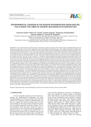
Fig. 7 - Location and extension of the urban area of Boiano, the waterlogged area and the ongoing debris production along the
piedmont area during various periods, reconstructed by means of archaeostratigraphical data coming from cores S1 and B6 (yellow
circles) and the examined archaeological excavations (for location see Fig. 3). Polygons in blue and orange indicate the presumed
extension of the waterlogged area and the ongoing debris cone sedimentation, respectively. A) the Boiano area before the IV-III
century B.C.; in yellow the aggradational piedmont zone. B) the boundaries of the Samnitic Bovianum and Roman Municipium dur-
ing the time period IV-III century B.C.-I century AD, marked by the defense walls (red lines). C) the layout hypothesis of the Roman
Colonia (red grid) with its centre, the Calderari archaeological area (B), during the I to IV century AD. D) the urban area of Boiano in
the time period V-IX century AD, partially affected by debris cone sedimentation and waterlogging. E) the hypothetical expansion
upslope of the modern village of Boiano (red polygon) during the XV to XVI centuries AD. F) the hypothetical extension of the mod-
ern village town of Boiano (red polygone) during the last centuries.
12. Amato V. et al.
26
od and until the XIX century AD the Boiano settlement
was particularly reduced in its urban extension and oc-
cupied only the piedmont area and the top of the Civita
palaeosurface. In the XV century AD the 1456 AD earth-
quake destroyed the S. Chiara Church and most of the
village of Boiano. Starting from this date, the more mar-
ginal sectors of the plain including the S. Chiara Church
were interested by debris cone deposition (US 8 in B6),
while the more central northward-located sector was af-
fected by fluvial-marshy sedimentation (US 9B in S1).
The debris cone deposition and the waterlogging of the
plain can be related most likely to the increase of rainfalls
and the decrease of temperature that characterized the
Little Ice Age, which interested the Mediterranean area
between the XVI-XIX centuries AD. These palaeoenvi-
ronmental changes could have been also influenced by
seismic events (1456 AD and 1805 AD earthquakes),
which may have caused coseismic subsidence. The ten-
dency to waterlogging persisted until very recent times
as highlights the several meters of man-made fills, which
were placed in order to raise the floor during the rebuild-
ing of the modern village of Boiano.
6. SUMMARY AND CONCLUDING REMARKS
As the collected archaeo-stratigraphic data high-
light, the area of Boiano has been affected in historical
times by important environmental changes evidenced by
the repeated deposition along the piedmont area of
scree/debris cone deposits that are laterally heteropic to
fluvial marshy deposits of the plain sector in front of it.
A synthetic view of main urban and environmental
changes occurred within the Boiano area in historical
times is given in figure 7. This figure illustrates (sketches
A-F) the location and extension of the urban area of Bo-
iano, the waterlogged area and the ongoing debris pro-
duction along the piedmont area over various periods.
Conversely, the evolution of the plain sector inside
and around the historical Boiano appears to have been
mainly controlled by repeated waterlogging, with excep-
tion to the Roman Colonia period (I-IV centuries AD),
during which an important land reclamation was carried
out (Fig. 7C). The waterlogged areas reached major ex-
tensions before the IV-III century B.C. (Fig. 7A) and from
the V century AD onwards (Figs. 7D-F). With regards to
the IV century B.C.-I century AD (Fig. 7B), instead, wa-
terlogging reached its major extent from the III to I cen-
turies B.C., when it affected the plain but did not interest
directly the Samnitic -Roman settlement. Waterlogging
could have been possibly favored by coseismic subsid-
ence induced by the earthquakes that occurred in the II-
I centuries B.C. -and in 853, 1456 and 1805 AD, respec-
tively. In any case, the historical phases of waterlogging
of the Boiano area, in our opinion, can be mainly as-
cribed to the increase of precipitation during the Cold
Dark Age and the Little Ice Age, but probably were also
influenced by the socio-political crisis that followed the
fall of the Roman Empire. Consequently to these envi-
ronmental changes, the Samnitic-Roman Bovianum, the
Roman Colonia and the Middle Age Age settlement of
Boiano changed in extension and location. As evi-
denced by the archaeological finds within the core S1,
the Roman Colonia (I-IV centuries AD) extended to-
wards the plain sector, probably beyond the actually
known boundaries, consequently to the land reclama-
tion. Subsequently, from the VI century AD to the XIX
century AD, the village of Boiano progressively reduced
the extension of its urban layout within the piedmont ar-
ea and was partially relocated on top of the Civita pal-
aeosurface. These changes of the urban layout have
been most likely caused both by the deterioration of the
plain sector due to waterlogging and the above men-
tioned social and political crises. A new reoccupation
phase of the plain started only in XX-XXI century, when
the emplacement of several meters of man-made fills
and extensive land reclamation allowed improving the
drainage conditions.
REFERENCES
Allocca F., Amato V., Coppola D., Giaccio B., Ortolani F.,
Pagliuca S. (2000) - Cyclical climatic-environmental
variations during the Holocene in Campania ed
Apulia: geoarcheological and palaeoethnological
evidences. Memorie della Società Geologica Italia-
na, 55, 345-352.
Amato V. (2006) - La risposta di alcuni tipici sistemi mor-
fodinamici della Campania (Italia meridionale) alle
variazioni climatiche oloceniche. PhD Thesis,
website www.fedoa.unina/636/, pp. 405.
Amato V., Aucelli P.P.C., Brancaccio L., Cesarano M,
Rosskopf C.M. (2010a) - Inquadramento geologi-
co-ambientale e geomorfologico. In: Colombo C.,
Guida pedologica ai suoli forestali del Matese mo-
lisano. Itinerari pedologici italiani/1, Aracne ed.,
61-97.
Amato V., Bisogno G., Cicala L., Cinque A., Romano P.,
Ruello M. R., Russo Ermolli E. (2010b) - Palaeo-
environmental changes in the archaeological sett-
lement of Elea-Velia: climatic and/or human impact
signatures? In: Senatore M. R., Ciarallo A., Scien-
ze Naturali ed Archeologia, Aracne ed., 13-17.
Amato V., Aucelli P. P. C., Cesarano M., Pappone G.,
Rosskopf C. M. Russo Ermolli E. (2011) - The
Sessano intramontane basin: new multi-proxy data
for the Quaternary evolution of the Molise sector of
the Central-Southern Apennines (Italy). Geomor-
phology, 128, 15-31, doi:10.1016/j.geomorph.2010.
12.019.
Amato V., Aucelli P.P.C., Russo Ermolli E., Rosskopf
C.M., Cesarano M., Pappone G. (2012) - Quater-
nary morpho-evolution, tectonic and environmental
changes in the Boiano intermontane basin (cen-
tral-southern Italy). Rend Online Società Geologi-
ca Italiana, 21, 1225-1227.
Amato V., Aucelli P.P.C., Ciampo G., Cinque A., Di Do-
nato V., Pappone G., Petrosino P., Romano P.,
Rosskopf C.M., Russo Ermolli E. (2013) - Relative
sea level changes and palaeogeographical evolu-
tion of the southern Sele plain (Italy) during the
Holocene. Quaternary International, 288, 112-128,
doi:10.1016/j.quaint.2012.02.003.
Aucelli P.P.C., Rosskopf C.M. (2000) - Last century val-
ley floor modifications of the Trigno river (S. Italy):
a preliminary report. Geografia Fisica e Dinamica
Quaternaria, 23 (2), 105-115.
Aucelli P.P.C., Robustelli G., Rosskopf C.M., Scarciglia
F., Di Paola G., Lucà F. (2010) - Geomorphologi-
13. The Boiano basin since the times of ancient Bovianum 27
cal Map of the area between Frosolone and Tri-
vento (Molise, Italy). Journal of Map, 423-434, doi:
10.4113/jom.2010.1039.
Aucelli P.P.C., Amato V., Cesarano M., Pappone G.,
Rosskopf C.M. Russo Ermolli E., Scarciglia F.
(2011) - New morphostratigraphic and chronologi-
cal constraints for the Quaternary palaosurfaces of
the Molise Apennines (southern Italy). Geologica
Carpathica, 62, 1, 17-26, doi:10.2478/v10096-011-
0002-2.
Barker G., Webley J.L., Webley D. (1978) - Classical
Landscape in Molise. Papers of the British School
at Rome, 46, 35-51.
Barker G, Hunt C. (2003) - The role of climate and hu-
man settlement in the evolution of the Biferno val-
ley (Molise, central-southern Italy). In Albore
Livadie C., Ortolani F., Climatic-environmental var-
iations and impact on man in the circum-
Mediterranean area. Edipuglia ed., 183-191.
Baroni C., Orombelli G. (1996) - The alpine Iceman and
Holocene climatic change. Quaternary Research,
46, 78-83.
Berglund B.E. (2003) - Human impact and climate chang-
es: synchronous events and a causal link? Quater-
nary International, 105, 7-12, doi: 10.1016/S1040-
6182(02)00144-1.
Berglund B.E., Birks H.J.B., Ralska-Jasiewiczowa M.,
Wright H.E. (1996) - Palaeoecological events dur-
ing the last 15000 years. Regional syntheses of
palaeoecological studies of lakes and mires in Eu-
rope. Wiley & Son, Chichester, pp. 764.
Bintliff J.L. (1982) - Palaeoclimatic modelling of environ-
mental changes in the East Mediterranean region
since the last glaciation. In: Bintliff J.L. and van
Zeist W., Palaeoclimates, palaeoenvironments and
human communities in the Eastern Mediterranean
region in Later Prehistory. British Archaeological
Reports, International Series 133, Oxford, 485-527.
Bond G., Kromer B., Beer J., Muscheler R., Evans M.,
Showers W., Hoffmann S., Lotti-Bond R., Hajdas I.,
Bonani G. (2001) - Persistent solar influence on
North Atlantic climate during the Holocene. Science,
294, 2130-2136, doi: 10.1126/science.1065680.
Borsato A., Cucchi F., Frisia S., Miorandi R., Paladini
M., Piccini L., Potleca M., Sauro U., Spötl C., Tuc-
cimei P., Villa I.M., Zini L. (2003) - Ricostruzione
climatica degli ultimi 17.000 anni da una stalagmi-
te della Grotta Savi (Trieste, Italia). Studi Trent.
Sci. Nat., Acta Geol., 80, 111-125.
Brancaccio L., Cinque A., Sgrosso I. (1979) - Forma e
genesi di alcuni versanti di faglia in rocce carbona-
tiche: il riscontro naturale di un modello teorico.
Rendiconti dell’Accademia di Scienze Fisiche e
Matematiche della Società Nazionale di Scienze,
Lettere ed Arti in Napoli, 4, 46, pp. 21.
Brancaccio L., Di Crescenzo G., Rosskopf C.M., San-
tangelo N., Scarciglia F. (2000) - Carta geologica
dei depositi quaternari e carta geomorfologica
dell’alta valle del fiume Volturno (Molise, Italia me-
ridionale). Note illustrative. Il Quaternario, Italian
Journal of Quaternary Science 13 (1/2), 81-94.
Buonocore M. (1992) - Una nuova testimonianza del
rector provinciae Autonius Iustinianus e il macel-
lum di Saepinum. Athenaeum, 80, 484-486.
Camodeca G. (1971) - Fabius Maximus e la creazione
della provincia del Samnium. Atti Accademia Pon-
taniana, 82, 249-264.
Capini S. (1980) - La necropoli di Campochiaro. Sannio,
1980, 108-112.
Ceglia V. (2005a) - San Massimo, il sepolcreto in locali-
tà Noce di Massaro, in De Benedittis G., Prima dei
Sanniti? La Piana di Bojano dall’Età del Ferro alle
Guerre Sannitiche attraverso i materiali archeolo-
gici. Campobasso, 2005, 97-100.
Ceglia V. (2005b) - Boiano (CB). Il lastricato stradale.
www.fastionline.org/docs/2005-32.pdf.
Chouquer G., Clavel Leveque M., Favory F., Vallat P.J.
(1987) - Structures agraires en Italie centro-
meridionale. Cadastres et paysage ruraux, Collec-
tion de l’Ecole francaise de Rome, pp. 432.
Coltorti M., Ferand G., Marzoli A., Peretto C., Ton That T.,
Voinchet P., Bohain J.J., Minelli A., Thun Hohens-
tein U. (2005) - New 40
Ar/39
Ar stratigraphic and pa-
laeoclimatic data on the Isernia La Pineta Lower
Palaeolithic site, Molise, Italy. Quaternary Interna-
tional, 131, 11-22, doi:10.1016/j.quaint.2004.07.004.
Corrado S., Di Bucci D., Naso G., Butler R.W.H. (1997) -
Thrusting and strike-slip tectonics in the Alto Moli-
se region (Italy): implications for the Neogene-
Quaternary evolution of the Central Apennine oro-
genic system. Journal of the Geological Society of
London, 154, 679-688.
Corrado S., Di Bucci D., Naso G., Valensise G. (2000) -
The role of pre-existing structures in Quaternary
extensional tectonics of the Southern Apennines,
Italy: the Boiano basin case history. Journal of the
Czech Geological Society, 45 (3/4), 217-231.
CPTI (2004) - Catalogo Parametrico dei Terremoti Ita-
liani, versione 2004 (CPTI04). INGV, Bologna.
Cremaschi M. (2000) - Manuale di geoarcheologia. La-
terza Editore, pp. 368.
Cronin T.M., Dwyer G.S., Kamiya T., Schwede S., Willard
D. A. (2003) - Medieval Warm Period, Little Ice Age,
and 20th Century Climate Variability from Chesa-
peake Bay. Global and Planetary Change, 36 (1-2),
17-29, doi.org/10.1016/S0921-8181(02)00161-3.
Daniels J.M. (2003) - Floodplain aggradation and pedo-
genesis in a semiarid environment. Geomorpholo-
gy, 56, 225-242, http://dx.doi.org 10.1016/S0169-
555X(03)00153-3.
De Benedittis G. (1977) - Bovianum ed il suo territorio.
Primi appunti di topografia antica. Documenti di
Antichità Italiche e Romane, Soprintendenza Ar-
cheologica del Molise, VII, pp.53.
De Benedittis G. (1995) - Repertorio delle iscrizioni ro-
mane del Molise: Bovianum. IRESMO, Campo-
basso, 12-16.
De Benedittis G. (2004) - Bovianum, Aesernia e Monte
Vairano: considerazioni sull’evoluzione dell’inse-
diamento nel Sannio Pentro. In: AA.VV., Samni-
um. Settlement and Cultural Change. Archeologia
Transatlantica XXII, Brown University 2004, 23-33.
De Benedittis G. (2005) - Prima dei Sanniti? La Piana di
Bojano dall’Età del Ferro alle Guerre Sannitiche
attraverso i materiali archeologici. IRESMO, Cam-
pobasso, 19-49.
De Benedittis G. (2012) - Ripensando ai terremoti del
Samnium: alcune note sull’area matesina tra IV
sec. AD e IV sec. d.C. Considerazioni di storia ed
archeologia, 5, 76-82.
14. Amato V. et al.
28
De Benedittis G., Ceglia V., Muccilli D., Melfi C. (2008) -
Dalla Bojano sannitica al Palazzo Colagrosso, Bo-
jano 2008, 8-10.
Deino, A.L., Orsi G., De Vita S., Piochi M. (2004) - The
age of the Neapolitan Yellow Tuff caldera forming
eruption (Campi Flegrei caldera - Italy) by 40Ar/
39Ar dating method. Journal of Volcanology and
Geothermal Research, 133, 157-170, http://dx.doi.
org/10.1016/j.bbr.2011.03.031.
De Menocal P.B. (2001) - Cultural responses to climate
change during the Late Holocene. Science, 292,
667-673, doi:10.1126/science.1059827.
Di Bucci D., Corrado S., Naso G. (2002) - Active faults
at the boundary between central and southern Ap-
ennines (Isernia, Italy). Tectonophysics, 359, 47-
63, doi.org/10.1016/S0040-1951(02)00414-6.
Di Bucci D., Naso G., Corrado S., Villa I.M. (2005) -
Growth, interaction and seismogenetic potential of
coupled active normal faults (Isernia Basin, cen-
tral-southern Italy). Terra Nova 17, 44-55, doi:
10.1111/j.1365-3121.2004.00582.x.
Frezza M. (1579) - De subfeudis baronum et investituris
feudorum, Venetiis, lib. I, 1579.
Galadini F., Galli P. (2004) - The 346 A.D. earthquake
(Central-Southern Italy): an archaeoseismological
approach. Annals of Geophysics, 47, 885-905.
Galli P., Galadini F. (2003) - Disruptive earthquakes re-
vealed by faulted archaeological relics in Samnium
(Molise, southern Italy). Geophysical Research
Letters, 30, 1266, 70/1-4.
Galli P., Galadini F., Capini S. (2002) - Analisi archeosi-
smologiche nel santuario di Ercole di Campochiaro
(Matese). Evidenze di un terremoto distruttivo
sconosciuto ed implicazioni sismotettoniche. Il
Quaternario, Italian Journal of Quaternary Scien-
ce, 15, 151-163.
Giraudi C. (1989) - Lake levels and climate for the last
30,000 years in the Fucino area (Abruzzo-Central
Italy). A review. Palaeogeography, Palaeoclimato-
logy, Palaeoecology, 70, 249-260, doi.org/10.1016/
0031-0182(89)90094-1.
Giraudi C. (1995) - Sedimenti eolici, variazioni climati-
che ed influenza antropica: Considerazioni su al-
cune piane intermontane dell’Appennino Abruzze-
se. Il Quaternario, Italian Journal of Quaternary
Science, 8(1), 211-216.
Giraudi C. (2004) - Le oscillazioni di livello del lago di
Mezzano (Valentano - VT): variazioni climatiche
ed interventi antropici. Il Quaternario, Italian Jour-
nal of Quaternary Science, 17, 221-230.
Giraudi C. (2005) - The Late Holocene alluvial events in
the Central Apennine (Italy). The Holocene, 15(5),
768-773, doi:10.1191/0959683605hl850rr.
Giraudi C., Magny M., Zanchetta G., Drysdale R.N.
(2011) - The Holocene climatic evolution of the
Mediterranean Italy: a review of the geological
continental data. The Holocene, 21, 105-117,
doi:10.1177/0959683610377531.
Giraudi C., Orombelli G., Ortolani F. (2007) - Variabilità
naturale del clima nell’Olocene ed in tempi storici:
un approccio geologico. Quaderni della Società
Geologica Italiana, pp. 24.
Hunt B.G. (2006) - The Medieval Warm Period, the Little
Ice Age and simulated climatic variability. Climate
Dynamics, 27 (7-8), 677-694, doi:10.1007/s00382-
006-0153-5.
La Regina A. (1966) - Le iscrizioni osche di Pietrabbon-
dante e la questione di Bovianum Vetus.
Rheinische Museum, CIX, 1966, 260-286.
Lamb H.H. (1995) - Climate, history and the modern
world. Routledge 2a edition, London, pp. 443.
Magny M., Vanniére B., Calo C., Millet L., Leroux A., Pey-
ron O., Zanchetta G., La Mantia T., Tinner W.
(2011) - Holocene hydrological changes in south-
western Mediterranean as recorded by lake-level
fluctuations at Lago Preola, a coastal lake in south-
ern Sicily, Italy. Quaternary Science Reviews, 30,
2459-2475, doi:10.1016/j.quascirev.2011.05.018.
Magny M., Begeot C., Guiot J., Peyron O. (2012) - Con-
trasting patterns of hydrological changes in Eu-
rope in response to Holocene climate cooling
phases. Quaternary Science Review, 22, 1589-
1596, doi:10.1002/jqs.1543.
Mann M. (2003) - Little Ice Age. In Mac Cracken M. M.
C. and Perry J. S., Encyclopedia of Global Envi-
ronmental Change, Volume 1, The Earth System:
Physical and Chemical Dimensions of Global Envi-
ronmental Change. John Wiley & Sons, 297-311.
Mayewski P.A., Rohling E.E., Stager J.C., Karlefin W,
Maasch K.A, Meeker L.D., Meyerson E.A., Gasse
F., van Kreveld S., Holmgren K., Lee-Thorp J.,
Rosqvist G., Rack F., Staubwasser M., Schneider
R.R., Steig E.J. (2004) - Holocene climate variabil-
ity. Quaternary Research, 62, 243-255, doi.org/
10.1016/j.yqres.2004.07.001.
McDermott F., Mattey D.P., Hawkesworth C. (2001) -
Centennial-scale Holocene climate variability re-
vealed by a high-resolution speleothem ð18O rec-
ord from SW Ireland. Science, 294, 1328-1331.
Messerli B., Grosjean M., Hofer T., Nunez L., Pfister C.
(2000) - From nature-dominated to human-
dominated environmental changes. Quaternary Sci-
ence Reviews, 19, 459-479, doi:http://dx.doi.org/
10.1016/S0277-3791(99)00075-X.
Muccilli O. (1985) - Presenza monastica nel territorio
bojanese. Note preliminari, Conoscenze, 2, 1-25.
Orain R., Lebreton V., Russo Ermolli E., Aucelli P.P.C.,
Amato V. (2012) - Végétation et climat au
Pléistocène moyen en Italie méridionale (Bassin
de Boiano, Molise). Quaternaire, 23, 35-46.
Orombelli G., Ravazzi C. (1996) - The late glacial and
early Holocene: chronology and paleoclimate. Il
Quaternario, Italian Journal of Quaternary Scien-
ce, 9(2), 439-444.
Ortolani F., Pagliuca S. (1994) - Variazioni climatiche e
crisi dell’ ambiente antropizzato. Il Quaternario, Ital-
ian Journal of Quaternary Science, 7(1), 351-356.
Ortolani F., Pagliuca S. (2003) - Cyclical climatic-
environmental changes in the Mediterranean Area
(2500 BP- Present day). Pages, 11(1), 15-17.
Pappone G., Alberico I., Amato V., Aucelli P.P.C., Di
Paola G. (2011) - Recent evolution and the pre-
sent-day condition of the Campanian coastal
plains (southern Italy): the case history of the Sele
river coastal plain. WIT Transactions on Ecology
and the Environment, 149, 15-27, doi:10.2495/
CP110021.
Pappone G., Aucelli P.P.C., Cesarano M., Putignano M.
L., Ruberti D. (2012) - Note illustrative della Carta
Geologica d’Italia alla scala 1:50.000, Foglio 405
15. The Boiano basin since the times of ancient Bovianum 29
"Campobasso". I.S.P.R.A., Servizio Geologico
d’Italia, pp. 160.
Patacca E., Scandone P. (2007) - Geology of the Sou-
thern Apennines. Bollettino Società Geologica Ita-
liana, Special Issue 7, 75-120.
Pescatore T.S., Cinque A., Senatore M.R., Rosskopf C.
(2004) - Historical-geological events and their im-
pact on man. Field trip guide book P14, 32nd In-
ternational Geological Congress, Firenze 2004,
pp. 44.
Piva A., Asioli A., Trincardi F., Schneider R., Vigliotti L.
(2008) - Late Holocene climate variability in the
Adriatic Sea (Central Mediterranean). The Holocene,
18, 1, 153-167, doi:10.1177/0959683607085606.
Pope K.O., van Andel T.H. (1984) - Late Quaternary
alluviation and soil formation in the southern Argol-
id: Its history, causes, and archaeological implica-
tions. Journal of Archaeological Science, 11, 281-
306, doi:10.1016/0305-4403(84)90012-8.
Pope R.J.J., Wilkinson K.N., Millington A.C. (2003) -
Human and Climatic Impact on Late Quaternary
deposition in the Sparta Basin piedmont: evidence
from alluvial fan systems. Geoarchaeology, 18(7),
685-724, doi:10.1002/gea.10089.
Roberts N., Jones M.D., Benkaddur A., Eastwood W.J.,
Filippi M.L., Frogley M.R., Lamb H.F., Leng M.,
Reed J.M., Stein M., Stevens L., Valero-Garcés
B., Zanchetta G. (2008) - Stable isotope records of
Late Quaternary climate and hydrology from Medi-
terranean Lakes: the ISOMED sysnthesis. Quater-
nary Science Reviews, 27, 2426-2441, doi:
10.1016/j.quascirev.2008.09.005.
Rosskopf C.M., De Benedittis G., Mauriello M. (2006) -
Indagini geoarcheologiche integrate nel Molise
Centrale (Italia meridionale): Il ponte romano di
Tufara. Il Quaternario, Italian Journal of Quater-
nary Science, 19 (2), 239-250.
Rosskopf C.M., Scorpio V. (2013) - Geomorphologic
map of the Biferno River valley floor system (Moli-
se, Southern Italy). Journal of Maps, doi:10.1080/
17530350.2012.755385.
Russi A. (1971) - L’amministrazione del Samnium nel IV
e V secolo d.C. III Miscellanea Greca e Romana,
Roma 1971, 307-346.
Russo F., Terribile F. (1995) - Osservazioni geomorfolo-
giche, stratigrafiche e pedologiche sul Quaternario
del bacino di Boiano (Campobasso). Il Quater-
nario, Italian Journal of Quaternary Science, 8 (1),
239-254.
Soil Survey Staff (2010) - Keys to soil taxonomy. 11th edi-
tion. U.S. Department of Agriculture, Natural Re-
sources Conservation Service. http://soils.usda.gov/
technical/classification/tax_keys/.
Soricelli G. (2009) - La Provincia del Samnium e il ter-
remoto del 346 d.C. Interventi Imperiali in campo
economico e sociale da Augusto al tardo antico.
Edipuglia, Bari, pp. 58.
Tucker M.E. (2011) - Sedimentary Rocks in the Field: A
Practical Guide, fourth ed. John Wiley and Sons,
Ltd, Chichester, England, pp. 275.
Valensise G., Pantosti D. (Eds.) (2001) - Database of
potential sources for earthquakes larger than M
5.5 in Italy: Annali di Geofisica 44, Suppl., with full
database on CDROM (in part available also at
www.ingv.it).
Vita-Finzi G. (1969) - The Mediterranean valleys: geo-
logical changes in historical times. Cambridge Un.
Press, pp. 140.
Young A. (1972) - Slopes. Oliver & Boyd, Edimburgh,
pp. 288.
Wilkinson K.N., Pope R.J.J. (2003) - Quaternary alluvia-
tion and archaeology in the Evrotas Valley, south-
ern Greece. In: Howard A.J. & Passmore D.
(Eds.), Alluvial archaeology in North-West Europe
and the Mediterranean, Rotterdam, 187-199.
Zolitschka B., Wulf S., Negendank J.F.W (2000) - Cir-
cum-Mediterranean lake records as archives of
climatic and human history. Quaternary Interna-
tional, 73/74, 1-5, doi:0.1016/j.bbr.2011.03.031.
Ms. received: December 2, 2012
Final text received: February 18, 2013