uttarakhand
•Télécharger en tant que PPT, PDF•
4 j'aime•8,501 vues

Uttarakhand became the 27th state of India in 2000 after being carved out of Uttar Pradesh. It has great geographical diversity including snow-clad mountains, hills, valleys, rivers and lakes. The state's economy depends heavily on tourism, with popular hill stations including Nainital, Mussoorie, and Ranikhet. Uttarakhand has a predominantly Hindu population that speaks languages like Hindi, Garhwali, and Kumauni and engages in cultural traditions around music, dance, festivals, and local deities.

Recommandé
Contenu connexe
Tendances
Tendances (20)
En vedette
En vedette (20)
Similaire à uttarakhand
Similaire à uttarakhand (20)
Plus de VISHAL THAKUR
Dernier
Dernier (17)
uttarakhand
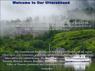
- 1. Uttarakhand became the 27th state of the Republic of India on 9thUttarakhand became the 27th state of the Republic of India on 9th November 2000. The State is carved out of Uttar Pradesh. It occupies 17.3% ofNovember 2000. The State is carved out of Uttar Pradesh. It occupies 17.3% of India's total land area with 51,125 sq km.India's total land area with 51,125 sq km. On Uttarakhand Travel, you will find the great diversity of the regionOn Uttarakhand Travel, you will find the great diversity of the region where snow-clad mountains, green hills, fertile valleys, flowing rivers and thrivingwhere snow-clad mountains, green hills, fertile valleys, flowing rivers and thriving lakes add to the natural beauty. The popular hill stations of Uttarakhand arelakes add to the natural beauty. The popular hill stations of Uttarakhand are Nainital, Bhimtal, Almora, Ranikhet, Pithoragarh, Munsiyari, Mussorie, Chopta,Nainital, Bhimtal, Almora, Ranikhet, Pithoragarh, Munsiyari, Mussorie, Chopta, Valley of Flowers, Joshimath and Lansdowne. For unlimited serenity andValley of Flowers, Joshimath and Lansdowne. For unlimited serenity and tranquilitytranquility Welcome to Our Uttarakhand Welcome to Our Uttarakhand
- 2. About UttarakhandAbout Uttarakhand In pleasant pollution free environs, hill stationIn pleasant pollution free environs, hill station on Uttarakhand Travel are ideal for vacations. To enhanceon Uttarakhand Travel are ideal for vacations. To enhance the attractiveness of the region are the several natural lakesthe attractiveness of the region are the several natural lakes in the region, which are the center of attraction of the townin the region, which are the center of attraction of the town and good for sporting activities. Since Uttarakhand isand good for sporting activities. Since Uttarakhand is known as the Abode of the gods, there are several highlyknown as the Abode of the gods, there are several highly venerated pilgrimage places. The tourists must visitvenerated pilgrimage places. The tourists must visit Kedarnath, Badrinath, Henmkund Sahib, GanotYamunotri,Kedarnath, Badrinath, Henmkund Sahib, GanotYamunotri, Jageshwar, Bageshwar,Rishikesh and Haridwar for theirJageshwar, Bageshwar,Rishikesh and Haridwar for their religious importance on Uttarakhand Travel. Each hilltopreligious importance on Uttarakhand Travel. Each hilltop or bent is known to have a temple, big or small, which areor bent is known to have a temple, big or small, which are considered very sacred by the localsconsidered very sacred by the locals..
- 3. About UttarakhandAbout Uttarakhand Uttarakhand is ideal for several adventure sports activitiesUttarakhand is ideal for several adventure sports activities because of its geographical attributes. While on Uttarakhandbecause of its geographical attributes. While on Uttarakhand Travel, the tourist must take the maximum pleasure out ofTravel, the tourist must take the maximum pleasure out of adventure sports like trekking, ice-skiing, white water rafting,adventure sports like trekking, ice-skiing, white water rafting, sailing, boating, kayaking, canoeing, yachting, water-skiingsailing, boating, kayaking, canoeing, yachting, water-skiing and parasailing. To climb the big mountain stretch or to passand parasailing. To climb the big mountain stretch or to pass the dense jungles of the hills is in itself very exciting. The hugethe dense jungles of the hills is in itself very exciting. The huge water-filled rivers and deep lakes are perfect for water sports.water-filled rivers and deep lakes are perfect for water sports. Tourists also prefer to go on Uttarakhand Travel toTourists also prefer to go on Uttarakhand Travel to visit the abundant wildlife sanctuaries and national parks in thevisit the abundant wildlife sanctuaries and national parks in the state. While you are on a visit to Uttarakhand, make sure tostate. While you are on a visit to Uttarakhand, make sure to visit the Valley of Flower National Park, Kedarnath Wildlifevisit the Valley of Flower National Park, Kedarnath Wildlife Sanctuaries, Nanda Devi National Park, Govind NationalSanctuaries, Nanda Devi National Park, Govind National Park, Assan Barrage National Park, Rajaji National Park andPark, Assan Barrage National Park, Rajaji National Park and Corbett National ParkCorbett National Park..
- 4. About UttarakhandAbout Uttarakhand Formation of State :-Formation of State :- Capital: Dehradun (Interim)Capital: Dehradun (Interim) Longitude: 77° 34' 27" E toLongitude: 77° 34' 27" E to 81° 02' 22" E81° 02' 22" E Latitude: 28° 53' 24" N to 31°Latitude: 28° 53' 24" N to 31° 27' 50" N27' 50" N Total Area: 53,484 sq. kmTotal Area: 53,484 sq. km Total Forest Area: 34,434 sq. km.Total Forest Area: 34,434 sq. km. Hilly Area : 92.57%Hilly Area : 92.57% Plains: 7.43%Plains: 7.43%
- 5. Important cities in UttarakhandImportant cities in Uttarakhand AlmoraAlmora BadrinathBadrinath BageshwarBageshwar ChamoliChamoli ChampawatChampawat DehradunDehradun RudraprayagRudraprayag KedarnathKedarnath KotdwarKotdwar MukteshwarMukteshwar NainitalNainital PithoragarhPithoragarh RanikhetRanikhet YamunotriYamunotri
- 6. UttarakhandUttarakhand Facts and FiguresFacts and Figures CapitalCapital DehradunDehradun ReligionReligion HinduismHinduism LanguagesLanguages Hindi, Garhwali, and KumauniHindi, Garhwali, and Kumauni Best Time To VisitBest Time To Visit April to JulyApril to July
- 7. Geographical Information Location Uttaranchal is a part of the WesternUttaranchal is a part of the Western Himalayan ranges starting from theHimalayan ranges starting from the Shivalik foothills to Greater HimalayasShivalik foothills to Greater Himalayas with Tibet as its northeasternwith Tibet as its northeastern border. In the northwestern corner of theborder. In the northwestern corner of the state is Himachal Pradesh, whilestate is Himachal Pradesh, while Haryana celebrates its union with theHaryana celebrates its union with the newly formed state with a gentle kiss.newly formed state with a gentle kiss. The state is surrounded by Uttar PradeshThe state is surrounded by Uttar Pradesh for most of its western and southernfor most of its western and southern boundaryboundary
- 8. Uttarakhandi LanguageUttarakhandi Language Languages Spoken:Languages Spoken: Uttarakhand Divided Two Parts firstUttarakhand Divided Two Parts first part Kumaun and second Partpart Kumaun and second Part Gadwall two part two languageGadwall two part two language Kumauni and Gadwalli language isKumauni and Gadwalli language is very simple of Uttrakhand (Kumauni,very simple of Uttrakhand (Kumauni, Garhwali, Hindi )Garhwali, Hindi )
- 9. Music and DanceMusic and Dance Garhwal :-Garhwal :- The Himalayas have inspired generations of singers,The Himalayas have inspired generations of singers, balladeers, and musicians throughout the ages. The naturalballadeers, and musicians throughout the ages. The natural beauty of the mountains which inspires a deep spiritualitybeauty of the mountains which inspires a deep spirituality and the harshness of life which darkens the heart withand the harshness of life which darkens the heart with adversity andadversity and anguish have invigorated Uttarakhandi music, heighteninganguish have invigorated Uttarakhandi music, heightening itsits poignancy and enriching its lyrical texture. Although,poignancy and enriching its lyrical texture. Although, increasingly influenced by trends in Hindi film music theincreasingly influenced by trends in Hindi film music the more traditional forms of Himalayan music have remainedmore traditional forms of Himalayan music have remained deeply popular. Major dance forms of the region aredeeply popular. Major dance forms of the region are Langvir Nritya, Barada Nati folk dance, Pandava Nritya,Langvir Nritya, Barada Nati folk dance, Pandava Nritya, Dhurang, and Dhuring.Dhurang, and Dhuring.
- 10. Music and DanceMusic and Dance KumaonKumaon :-:- The Kumaonese are fond of music, folkThe Kumaonese are fond of music, folk dance, and songs accompanied by local musicaldance, and songs accompanied by local musical instruments like murli, bina, and hurka.instruments like murli, bina, and hurka. The hurka is played by the “jurkiya” and theThe hurka is played by the “jurkiya” and the dancer accompanying him, known as “hurkiyari,”dancer accompanying him, known as “hurkiyari,” is usually his wife or daughter. They go from placeis usually his wife or daughter. They go from place to place narrating folklores, singing the praise ofto place narrating folklores, singing the praise of their gods and goddesses. During fairs andtheir gods and goddesses. During fairs and festivals andfestivals and at harvest time, the Kumaonese often dance theat harvest time, the Kumaonese often dance the Jharva, Chandhur Chhapalior, and many otherJharva, Chandhur Chhapalior, and many other forms of folk dances.forms of folk dances. The popular folk songs are Malushahi, Bair, andThe popular folk songs are Malushahi, Bair, and Hurkiya BolHurkiya Bol
- 11. Physical FeaturesPhysical Features Apart from the Terai region in the ShivalikApart from the Terai region in the Shivalik foothills, the entire state of Uttaranchal is a part of thefoothills, the entire state of Uttaranchal is a part of the Himalayan ranges. At 7,817 m above sea level, NandaHimalayan ranges. At 7,817 m above sea level, Nanda Devi in the district of Chamoli is the highest point inDevi in the district of Chamoli is the highest point in the state. The region has many glaciers, passes,the state. The region has many glaciers, passes, meadows, and trekking routes with several major riversmeadows, and trekking routes with several major rivers like the Ganga and Yamuna originating from here. Alike the Ganga and Yamuna originating from here. A major part of this Himalayan state comes undermajor part of this Himalayan state comes under rainforests and alpine forests that are home to some ofrainforests and alpine forests that are home to some of the highly endangered wildlife speciesthe highly endangered wildlife species
- 12. ClimateClimate The state has two distinct climatic regions: theThe state has two distinct climatic regions: the predominant hilly terrain and the small plain region.predominant hilly terrain and the small plain region. The climatic condition of the plains is very similar to itsThe climatic condition of the plains is very similar to its counterpart in the Gangetic plain—that is, tropical.counterpart in the Gangetic plain—that is, tropical. Summers are unbearable with temperature going overSummers are unbearable with temperature going over the 40°C mark and a lot of humidity. Winters can bethe 40°C mark and a lot of humidity. Winters can be chilly with temperatures going below 5°C at times.chilly with temperatures going below 5°C at times. The Himalayan region has Alpine conditionsThe Himalayan region has Alpine conditions characterized by cold winters with snowfall for quite acharacterized by cold winters with snowfall for quite a long time, good rainfall in the monsoon, and mildlong time, good rainfall in the monsoon, and mild summers. This climate also provides the state with itssummers. This climate also provides the state with its only livelihood, i.e., tourism.only livelihood, i.e., tourism.
- 13. EthnicityEthnicity GarhwalGarhwal :-:- Garhwal resembles otherGarhwal resembles other parts of the Himalayasparts of the Himalayas where various ethnicwhere various ethnic groups live side by side.groups live side by side. Following chiefly theFollowing chiefly the agrarian-pastoral way ofagrarian-pastoral way of life, native Garhwali'slife, native Garhwali's make their living from themake their living from the hilly land the best theyhilly land the best they can. Some, like the Bhotiacan. Some, like the Bhotia traders,traders,.. Kumaon:-Kumaon:- The inhabitants of the KumaonThe inhabitants of the Kumaon hills are commonly known ashills are commonly known as the Kumaonese. They belong tothe Kumaonese. They belong to a predominantly patriarchala predominantly patriarchal society, which recognizes thesociety, which recognizes the superiority of men over women.superiority of men over women. The social structure is based onThe social structure is based on the extended family system,the extended family system, Women are respected in societyWomen are respected in society but they usually confinebut they usually confine themselves to householdthemselves to household activities. Widow marriage andactivities. Widow marriage and re-marriage by divorced womenre-marriage by divorced women is permitted except in certainis permitted except in certain sections of high-caste Brahminssections of high-caste Brahmins and Rajputsand Rajputs..
- 14. Fairs and FestivalsFairs and Festivals The major fairs and festivals of theThe major fairs and festivals of the Garhwal region are Hatkalika Fair,Garhwal region are Hatkalika Fair, Tapkeshwar Fair, Surkhanda Devi Mela,Tapkeshwar Fair, Surkhanda Devi Mela, Kunjapuri Fair, Lakhawar Village Fair,Kunjapuri Fair, Lakhawar Village Fair, and Mata Murti Ka Mela.and Mata Murti Ka Mela. The major fairs and festivals ofThe major fairs and festivals of Kumaon region are Uttarayani Mela,Kumaon region are Uttarayani Mela, Shravan Mela (Jageshwar), KartikShravan Mela (Jageshwar), Kartik Poornima at Dwarahat, Kasar Devi fair,Poornima at Dwarahat, Kasar Devi fair, and Nanda Devi melasand Nanda Devi melas
- 15. AgricultureAgriculture The Terai region has great potential to feed the entire state by itsThe Terai region has great potential to feed the entire state by its large productivity. The district of Udham Singh Nagar has largelarge productivity. The district of Udham Singh Nagar has large farms and enterprising agriculturists producing large amounts offarms and enterprising agriculturists producing large amounts of grains and cash crops. However, there is not much potential forgrains and cash crops. However, there is not much potential for agriculture in the large Himalayan tract in this stateagriculture in the large Himalayan tract in this state
- 16. Tourist CentersTourist Centers Opportunities for tourism are immense in thisOpportunities for tourism are immense in this state, be it nature, wildlife, adventure, and pilgrimagestate, be it nature, wildlife, adventure, and pilgrimage tourism. The major destinations are Haridwar,tourism. The major destinations are Haridwar, Rishikesh, Dehradun, Mussoorie, Almora, Kedarnath,Rishikesh, Dehradun, Mussoorie, Almora, Kedarnath, Badrinath, Yamunotri, Gangotri, Jim Corbett NationalBadrinath, Yamunotri, Gangotri, Jim Corbett National Park, Nainital, Ranikhet, and Pithoragarh.Park, Nainital, Ranikhet, and Pithoragarh. If you are adventurous and like tough challenges,If you are adventurous and like tough challenges, you can go for high- and low-altitude trekking, riveryou can go for high- and low-altitude trekking, river rafting, Para gliding, hang-gliding, mountaineering,rafting, Para gliding, hang-gliding, mountaineering, skiing, and many others.skiing, and many others.
- 17. Famous Place in UttarakhandFamous Place in Uttarakhand Deharadun :-Deharadun :- Deharadun isDeharadun is a Capital of Uttrakhanda Capital of Uttrakhand,, Nainital :-Nainital :- The Place isThe Place is very Famous invery Famous in Uttarakhand Many touristsUttarakhand Many tourists visits in Nainitalvisits in Nainital Ranikhet:-Ranikhet:- Ranikhet is aRanikhet is a Famous and Beautiful andFamous and Beautiful and Hill area. Every SessionsHill area. Every Sessions this place very cool.this place very cool. Haldwani:-Haldwani:- Haldwani is famousHaldwani is famous area in Uttrakhandarea in Uttrakhand Haridwar :-Haridwar :- Haridwar isHaridwar is situated at the base of thesituated at the base of the Shivalik hills, where theShivalik hills, where the Ganga, comes down fromGanga, comes down from the mighty. Himalayas meetsthe mighty. Himalayas meets the plains. Haridwar, literallythe plains. Haridwar, literally is The gateway to theis The gateway to the Gods'." This place is veryGods'." This place is very “at one sight one will say so“at one sight one will say so and fall in love withand fall in love with beautiful the scenic beautybeautiful the scenic beauty of the blend of height andof the blend of height and plainsplains
- 18. Nainital, Mussoorie, Pauri,Nainital, Mussoorie, Pauri, Almora, Ranikhet, Khirsu,Almora, Ranikhet, Khirsu, Champawat, Dayara, Auli,Champawat, Dayara, Auli, Khatling, Vedini Bugyal,Khatling, Vedini Bugyal, Valley Of Flowers, Lansdown,Valley Of Flowers, Lansdown, Lakhamandal, PaataalLakhamandal, Paataal Bhuvaneshwar, Gangolihaat, Jolljivi,Bhuvaneshwar, Gangolihaat, Jolljivi, Kataarmal, Kosini, Jageshwar,Kataarmal, Kosini, Jageshwar, Dwarahaat, Someshwar, Baijnath,Dwarahaat, Someshwar, Baijnath, Pindari Glacier etc.Pindari Glacier etc. Tourist And Historical Places :Tourist And Historical Places :
- 19. How to Reach In UttarakhandHow to Reach In Uttarakhand 1. By Air1. By Air Jolly Grant near Dehradun is the only airport. There are regular flights toJolly Grant near Dehradun is the only airport. There are regular flights to Delhi by Indian Airlines. Otherwise, one has the option to travel to Delhi byDelhi by Indian Airlines. Otherwise, one has the option to travel to Delhi by road or rail and then take the air route to various destinationsroad or rail and then take the air route to various destinations.. 2.2. By RailBy Rail Dehradun, Haridwar, and Kathgodam are the major railway stationsDehradun, Haridwar, and Kathgodam are the major railway stations connected to almost all parts of the country with regular trains. Not manyconnected to almost all parts of the country with regular trains. Not many places in the state are connected by rail because of tough terrains. For thoseplaces in the state are connected by rail because of tough terrains. For those visiting places in the higher altitudes, trekking and road routes are the onlyvisiting places in the higher altitudes, trekking and road routes are the only options availableoptions available 3.3. By RoadBy Road Almost all the important places in the state are connected by all-weatherAlmost all the important places in the state are connected by all-weather metalled roads. Many places in the higher altitudes may still remain off for ametalled roads. Many places in the higher altitudes may still remain off for a period in the year due to landslides and snowfall. National Highways such asperiod in the year due to landslides and snowfall. National Highways such as 58, 73, 74, and 87 connect places in the state to other parts of the country.58, 73, 74, and 87 connect places in the state to other parts of the country.
- 20. ABOUT RANIKHETABOUT RANIKHET Ranikhet is situated in the northern part of the state ofRanikhet is situated in the northern part of the state of Uttaranchal, in the northern region of India. It is situated inUttaranchal, in the northern region of India. It is situated in the Kumaon hills and is located on an altitude of 1824 mthe Kumaon hills and is located on an altitude of 1824 m above sea level. Ranikhet is 59 km from Nainital and 50 kmabove sea level. Ranikhet is 59 km from Nainital and 50 km from Almora. The weather in Ranikhet is alpine. Summersfrom Almora. The weather in Ranikhet is alpine. Summers (April-June) are mild and winters are cold (November-(April-June) are mild and winters are cold (November- February). It experiences southwestern monsoon rains inFebruary). It experiences southwestern monsoon rains in July-September and experiences snowfall in winters.July-September and experiences snowfall in winters.
- 21. BEST TIME TO VISITBEST TIME TO VISIT RANIKHET UTTRAKHANDRANIKHET UTTRAKHAND Ranikhet can be visitedRanikhet can be visited throughout the year. However, itthroughout the year. However, it experiences snowfall in winters.experiences snowfall in winters. Area 21.75 sq km Altitude 1,800 m aboveArea 21.75 sq km Altitude 1,800 m above sea level Languages Hindi, English,sea level Languages Hindi, English, Kumaoni Population16,875 Annual MeanKumaoni Population16,875 Annual Mean Rainfall 1294.5mmTemperature18°C - 7.6 °CRainfall 1294.5mmTemperature18°C - 7.6 °C STD Code 05966STD Code 05966
- 22. HISTORY OF RANIKHETHISTORY OF RANIKHET UTTRAKHANDUTTRAKHAND According to popular belief, Ranikhet Uttaranchal gotAccording to popular belief, Ranikhet Uttaranchal got its name when Rani Padmini, queen of Raja Sukherdev,its name when Rani Padmini, queen of Raja Sukherdev, the local ruler, saw this place and was struck by itsthe local ruler, saw this place and was struck by its beauty. She was so captivated by the place that shebeauty. She was so captivated by the place that she decided to stay there, and the place came to be knowndecided to stay there, and the place came to be known as Ranikhet (literally, queen's field). The region aroundas Ranikhet (literally, queen's field). The region around Ranikhet was ruled by local Kumaoni rulers and laterRanikhet was ruled by local Kumaoni rulers and later came under British rule. The British developedcame under British rule. The British developed Ranikhet as a hill station for their troops andRanikhet as a hill station for their troops and established a cantonment in 1869. Ranikhet is still aestablished a cantonment in 1869. Ranikhet is still a cantonment town and is the Kumaon Regimentalcantonment town and is the Kumaon Regimental CenterCenter..
- 23. TOURISTS ATTRACTIONS INTOURISTS ATTRACTIONS IN RANIKHET UTTRAKHANDRANIKHET UTTRAKHAND Ranikhet Uttaranchal offers an excellentRanikhet Uttaranchal offers an excellent view of the great Himalayan peak of Nanda Deviview of the great Himalayan peak of Nanda Devi (7816 m). Travelers can take a walk around the(7816 m). Travelers can take a walk around the town and its sylvan surroundings. The Jhula Devitown and its sylvan surroundings. The Jhula Devi temple and the Chaubatia orchards are withintemple and the Chaubatia orchards are within walking distance, south of the main Mall Road.walking distance, south of the main Mall Road. Bhaludham, 3 km away, is an artificial lake. UpatBhaludham, 3 km away, is an artificial lake. Upat Kalika, 4 km north of Ranikhet and on the mainKalika, 4 km north of Ranikhet and on the main road to Almora, offers panoramic view of theroad to Almora, offers panoramic view of the Himalayan ranges and has a nine-hole golfHimalayan ranges and has a nine-hole golf course.course.
- 24. PLACES AROUND RANIKHETPLACES AROUND RANIKHET UTTRAKHANDUTTRAKHAND There are a number of places toThere are a number of places to visit near Ranikhet. The famousvisit near Ranikhet. The famous tourist center of Nainital is 59 kmtourist center of Nainital is 59 km from Ranikhet. Nainital is famousfrom Ranikhet. Nainital is famous for its Naini Lake and a number offor its Naini Lake and a number of picnic spots in and around it.picnic spots in and around it. Almora is 50 km from Ranikhet, isAlmora is 50 km from Ranikhet, is famous for its health resorts andfamous for its health resorts and panoramic views of the Himalayanpanoramic views of the Himalayan ranges.ranges. Dwarahat, 38 km away, was onceDwarahat, 38 km away, was once the principal seat of the Katyurithe principal seat of the Katyuri Rajas. It is full of ancientRajas. It is full of ancient sculptures.sculptures. Sitalakhet (35 km), Tarikhet (8 km)Sitalakhet (35 km), Tarikhet (8 km) and Khairna (22 km) are some ofand Khairna (22 km) are some of the places that one can visit fromthe places that one can visit from Ranikhet.Ranikhet.
- 25. Places on InterestPlaces on Interest Bright End Corner:Bright End Corner: Almora is at a 2 km distance from here. TheAlmora is at a 2 km distance from here. The significance of this place is amazing sunset and the sunrise seensignificance of this place is amazing sunset and the sunrise seen through the Himalayan peaks. A circuit house close by allowsthrough the Himalayan peaks. A circuit house close by allows tourists to spend some peaceful moments at this place. Bear by istourists to spend some peaceful moments at this place. Bear by is the Vivekananda Library which has a good collection of booksthe Vivekananda Library which has a good collection of books on literature. A little away is the Vivekananda Memorial whereon literature. A little away is the Vivekananda Memorial where Swami Vivekananda had stopped for a short while on his way toSwami Vivekananda had stopped for a short while on his way to the Himalayas.the Himalayas. Chitai Temple:Chitai Temple: This is a very busy neighborhood. This templeThis is a very busy neighborhood. This temple is dedicated to Lord Golu. The natives of Kumau worship him.is dedicated to Lord Golu. The natives of Kumau worship him. Once a wish is fulfilled people hang little bells in this temple. ForOnce a wish is fulfilled people hang little bells in this temple. For that reason there are thousands of little bells hanging there. Thethat reason there are thousands of little bells hanging there. The view of the Himalayas is extremely stunning from here. Thisview of the Himalayas is extremely stunning from here. This temple is 8 kms away by walk all the way through a beautiful pinetemple is 8 kms away by walk all the way through a beautiful pine forest, one can go by horse and cart too.forest, one can go by horse and cart too.
- 26. About AlmoraAbout Almora Almora is a wonderful hill station in the shape of a horseAlmora is a wonderful hill station in the shape of a horse shoe from where the magnificent snow of the centralshoe from where the magnificent snow of the central Himalayas could be seen. It is situated on a 5 km longHimalayas could be seen. It is situated on a 5 km long mountain range.Almora has its own historical, cultural andmountain range.Almora has its own historical, cultural and political significance. It was the capital of Kumau once uponpolitical significance. It was the capital of Kumau once upon a time, set up by King Balo Kalyan Chand in 1563.Thea time, set up by King Balo Kalyan Chand in 1563.The descendents from the Kyutar dynasty and the Chand dynastydescendents from the Kyutar dynasty and the Chand dynasty ruled Almora in the old times. The forts, other historicalruled Almora in the old times. The forts, other historical monuments, courts and legislative offices are present evenmonuments, courts and legislative offices are present even today. The two rivers, Kaushik (Koshi) and Shalmali (Suyal)today. The two rivers, Kaushik (Koshi) and Shalmali (Suyal) flow near the town. The snow peaked mountains of theflow near the town. The snow peaked mountains of the Himalayas look like a spectacular train of ice and snow fromHimalayas look like a spectacular train of ice and snow from herehere..
- 27. Pilgrimage Sites :Pilgrimage Sites : Badrinath, Kedarnath,Badrinath, Kedarnath, Gangotri, Yamunotri,Gangotri, Yamunotri, Panchkedar, Panchbadri,Panchkedar, Panchbadri, Panchprayag, Haridwar,Panchprayag, Haridwar, Rishikesh, Hemkund Sahib,Rishikesh, Hemkund Sahib, Purnagiri, Chittai,Purnagiri, Chittai, Kaliyar Sharif, Nanakmatta Sahib,Kaliyar Sharif, Nanakmatta Sahib, Rettha Sahib etc.Rettha Sahib etc.
- 28. Famous Temple of UttarakhandFamous Temple of Uttarakhand Deer Park:Deer Park: 3 kms from Almora is the deer park.3 kms from Almora is the deer park. Catarrhal:Catarrhal: This 800-year old Sun Temple is the next in significance after the SunThis 800-year old Sun Temple is the next in significance after the Sun Temple of Konark in Orissa. Seven kms away from Almora, this historicalTemple of Konark in Orissa. Seven kms away from Almora, this historical important temple is an excellent example of intricate sculpturingimportant temple is an excellent example of intricate sculpturing.. Nanda Devi Temple:Nanda Devi Temple: This 1000-year old temple is one of the main attractions ofThis 1000-year old temple is one of the main attractions of Almora. Its known for its famous wall carvings. Each year a festival is held hereAlmora. Its known for its famous wall carvings. Each year a festival is held here in which youth from various hilly areas participate in dance festivalsin which youth from various hilly areas participate in dance festivals.. Kasar Devi:Kasar Devi: Near Kali mutt is the temple of Kasar Devi. This ancient templeNear Kali mutt is the temple of Kasar Devi. This ancient temple was built in the second century on a mountain peak. The distance between Kaliwas built in the second century on a mountain peak. The distance between Kali matt and Kasar Devi is less than 1 km and can be easily covered by foot. Thematt and Kasar Devi is less than 1 km and can be easily covered by foot. The neighboring area has turned out to be the home of many foreigners. The mainneighboring area has turned out to be the home of many foreigners. The main town is 6 km away.town is 6 km away.
- 29. Chitai TempleChitai Temple Chitai Temple (Near Nainital/Almora inChitai Temple (Near Nainital/Almora in Uttaranchal, North India) is dedicated to Lord Golu.Uttaranchal, North India) is dedicated to Lord Golu. The people of Kumaon worship him as a Justice God.The people of Kumaon worship him as a Justice God. Saying goes that whatever wish you have if fulfilled onceSaying goes that whatever wish you have if fulfilled once you convey the same to Lord Golu, here at the temple.you convey the same to Lord Golu, here at the temple. Once a wish is fulfilled people hang little bells in thisOnce a wish is fulfilled people hang little bells in this temple. Therefore there are thousands of little bellstemple. Therefore there are thousands of little bells hanging there. The view of the Himalayas is extremelyhanging there. The view of the Himalayas is extremely beautiful from here. This temple is 8 kms away by walkbeautiful from here. This temple is 8 kms away by walk through a beautiful pine forest and also has a motorablethrough a beautiful pine forest and also has a motorable roadroad
- 30. Ramesh Pokhriyal replaces Khanduri asRamesh Pokhriyal replaces Khanduri as The Uttarakhand BJPThe Uttarakhand BJP legislative party has chosenlegislative party has chosen state Health Minister Rameshstate Health Minister Ramesh Pokhriyal Nishank as state’s next ChiefPokhriyal Nishank as state’s next Chief Minister. Considered to be close to BCMinister. Considered to be close to BC Khanduri, Nishank is a strong leader fromKhanduri, Nishank is a strong leader from Garhwal and is known to be close to the RSS.Garhwal and is known to be close to the RSS.
- 31. Khanduri resigns as Uttarakhand’s CMKhanduri resigns as Uttarakhand’s CM Uttarakhand Chief Minister B C Khanduri stepped down on Tuesday bowing to pressure from dissidents – aggravated after the party lost all five Lok Sabha seats in the state. The names of state minister for tourism Prakash Pant and health minister Ramesh Pokhriyal are doing the rounds as possible replacements
- 32. MPs of UttarakhandMPs of Uttarakhand Shri Vijay Bahuguna:-Shri Vijay Bahuguna:- Details of Member Particulars Description Name Shri Vijay Bahuguna Constituency from which I am elected Tehri Garhwal State from which I am elected Uttarakhand Political party Indian National Congress (INC) Present Address A-14, Friends Colony (East),Mathura Road, New Delhi - 110065,Tel. (011) 26923379, 9910062660 (M) Permanent Address D - 13, Sector - 1, Defence ColonyDehradun, Uttarakhand,Tel. (0135) 2666660 B.A., LLB.Educated at Allahabad University Educational Qualifications 28'th Feb., 1947
- 33. MPs of UttarakhandMPs of Uttarakhand Shri Satpal Maharaj:-Shri Satpal Maharaj:- Details of Member Particulars Description Name Shri Satpal Maharaj Constituency from which I am elected Garhwal State from which I am elected Uttarakhand Political party Indian National Congress (INC) Present Address Tels. 9013180355 (M) Permanent Address 13, Municipal Road,Dehradun (Uttarakhand),Tel. (0135) 2654514, Fax 2650088 Senior Cambridge Educated at St. George's College, Mussoorie (Uttarakhand) Education Qualification 21-09-1951
- 34. MPs of UttarakhandMPs of Uttarakhand Shri Harish Rawat:-Shri Harish Rawat:- Details of Member Particulars Description Name Shri Harish Rawat Constituency from which I am elected Hardwar State from which I am elected Uttarakhand Political party Indian National Congress (INC) Present Address -NA- Permanent Address Khat, District Pithoragarh,Uttar Pradesh B.A., LL.BEducated at Lucknow University Education Qualification 27-04-1947
- 35. MPs of UttarakhandMPs of Uttarakhand Shri K.C. Singh BabaShri K.C. Singh Baba Details of Member Particulars Description Name Shri K.C. Singh Baba Constituency from which I am elected Nainital-Udhamsingh Nagar State from which I am elected Uttarakhand Political party Indian National Congress (INC) Present Address 4, Mahadev RoadNew Delhi - 110 001,Tels. (011) 23359787, 9868180299 (M) Permanent Address Fort Kashipur, Mohalla Katora Tal,P.O. Kashipur, Distt. Nainital (Uttaranchal),(05947)274886,223144, 9868180299 (M) Education Qualification Senior Cambridge Educated at St. Joseph`s College, Nainital 29-03-1947
- 36. MPs of UttrakhandMPs of Uttrakhand Shri Pradeep Tamta:-Shri Pradeep Tamta:- Details of Member Particulars Description Name Shri Pradeep Tamta Constituency from which I am elected Almora State from which I am elected Uttarakhand Political party Indian National Congress (INC) Present Address Tels. 9013180055 (M) Permanent Address -NA- Education Qualificati M.A, LL.B and B.Ed. 16'th June, 195
- 37. उत्तराचंल की प्रमुख नदिदियांउत्तराचंल की प्रमुख नदिदियां गंगागंगा,, यमुनदायमुनदा,, कालीकाली,, रामगंगारामगंगा,, भागीरथीभागीरथी,, अलकनदन्दिाअलकनदन्दिा,, कोसीकोसी,, गोमतीगोमती,, टौंसटौंस,, मंदिािकनदीमंदिािकनदी,, धौली गंगाधौली गंगा,, गौरीगंगागौरीगंगा,, िपिंडर नदयारिपिंडर नदयार((पिंूपिंू)) िपिंडर नदयारिपिंडर नदयार ((पिंपिं)) आदिी प्रमुख नददिीयांआदिी प्रमुख नददिीयां हैं।हैं।
- 38. उत्तराचंल के प्रमुख ग्लेिशियरउत्तराचंल के प्रमुख ग्लेिशियर 1.1.गंगोत्रीगंगोत्री 2.2. यमुनदोत्रीयमुनदोत्री 3.3. िपिंण्डरिपिंण्डर 4.4. खतिलगंखतिलगं 5.5. िमलमिमलम 6.6. जौिलकांगजौिलकांग,, 7.7. सुन्दिर ढूंगा इत्यािदि।सुन्दिर ढूंगा इत्यािदि।
- 39. उत्तराचंल के प्रमुख िहिमिशिखरउत्तराचंल के प्रमुख िहिमिशिखर गंगोत्रीगंगोत्री (6614),(6614), दूनगिगिरदूनगिगिर (7066),(7066), बंदरपूछबंदरपूछ (6315),(6315), केदारनगाथकेदारनगाथ (6490),(6490), चौखंवाचौखंवा (7138),(7138), कामेतकामेत (7756),(7756), सतोपंथसतोपंथ (7075),(7075), नगीलकंठनगीलकंठ (5696),(5696), नगंदा देवीनगंदा देवी (7817),(7817), गोरी पवर्वतगोरी पवर्वत (6250),(6250), हिाथी पवर्वतहिाथी पवर्वत (6727),(6727), नगंदा धुंटीनगंदा धुंटी (6309),(6309), नगंदा कोटनगंदा कोट (6861)(6861) देव वनगदेव वनग (6853),(6853), मानगामानगा (7273),(7273), मृगथनगीमृगथनगी (6855),(6855), पंचाचूलीपंचाचूली (6905),(6905), गुनगीगुनगी (6179),(6179), यूंगटागटयूंगटागट (6945)(6945)।।
- 40. उत्तराचंल के प्रमुख दरेउत्तराचंल के प्रमुख दरे बरासबरास- 5365- 5365मीमी.,(.,(उत्तरकाशिीउत्तरकाशिी),), माणामाणा- 6608- 6608मीमी.(.(चमोलीचमोली),), नगोतीनगोती-5300-5300मीमी. (. (चमोलीचमोली),), बोल्छाधुराबोल्छाधुरा-5353-5353मीमी.,(.,(िपथौरागडिपथौरागड),), कुरंगीकुरंगी--वुरंगीवुरंगी-5564-5564 मीमी.(.( िपथौरागडिपथौरागड),), लोवेपुरालोवेपुरा-5564-5564मीमी. (. (िपथौरागडिपथौरागड),), लमप्याधुरालमप्याधुरा-5553-5553 मीमी. (. (िपथौरागडिपथौरागड),), िलपुलेशििलपुलेशि-5129-5129 मीमी. (. (िपथौरागडिपथौरागड),), उंटाबुराउंटाबुरा,, थांगलाथांगला,, ट्रेलपासट्रेलपास,, मलारीपासमलारीपास,, रालमपासरालमपास,, सोग चोगसोग चोग ला पुिलग लाला पुिलग ला,, तुनगजुनगलातुनगजुनगला,, मरहिीलामरहिीला,, िचरीचुनग दरार्व।िचरीचुनग दरार्व।
- 41. उत्तराचंल के वनग अभ्यारण्यउत्तराचंल के वनग अभ्यारण्य 1.1. गोविविन्द विन जीवि िविहारगोविविन्द विन जीवि िविहार 2.2. के दारनाथ विन्य जीवि िविहारके दारनाथ विन्य जीवि िविहार 3.3. अस्कोवट जीवि िविहारअस्कोवट जीवि िविहार 4.4. सोवना नदी विन्य जीवि िविहारसोवना नदी विन्य जीवि िविहार 5.5. िविनसर विन्य जीवि िविहारिविनसर विन्य जीवि िविहार
- 42. उत्तराखण्ड के लोक गीतःउत्तराखण्ड के लोक गीतः गीत और संगीत उत्तराखण्ड संस्कृित का अनगािदकाल से महित्तवपूणर्व अंगगीत और संगीत उत्तराखण्ड संस्कृित का अनगािदकाल से महित्तवपूणर्व अंग रहिा हिै। हिर मौकों पर गीत गाए जाते हिैं। यहिाँ तक िक जब पवर्वतीय मिहिलाएँ घास काटनगे जंगलोंरहिा हिै। हिर मौकों पर गीत गाए जाते हिैं। यहिाँ तक िक जब पवर्वतीय मिहिलाएँ घास काटनगे जंगलों में जाती हिैं वहिां भी लोकगीत गाये या गुनगगुनगाए जाते हिैं। कुछ लोक गीतों का िववरण इस प्रकारमें जाती हिैं वहिां भी लोकगीत गाये या गुनगगुनगाए जाते हिैं। कुछ लोक गीतों का िववरण इस प्रकार हिैःहिैः-- मांगलःमांगलः-- यहि गीत शिभ कायों एंव शिादी िववाहि केयहि गीत शिभ कायों एंव शिादी िववाहि के मौकपर गाये जाते हिैं।मौकपर गाये जाते हिैं। जागरःजागरः-- जागर देवताओं के गीत हिै जैसेजागर देवताओं के गीत हिै जैसे-- िवनगसरिवनगसर,, नगागजार्वनगागजार्व,, नगरिसहिनगरिसहि,, भैरोंभैरों,, ऐडीऐडी,, आछरीआछरी,, जीतूजीतू,, लाटूलाटू,, भगवतीभगवती,, चिण्डकाचिण्डका,, गालू देवता आदी।गालू देवता आदी। पंडोवःपंडोवः -- पंडोव गढ़वाली लोक सािहित्य के मौिलक महिाकाव्य तथा खण्ड काव्य हिै। इनग गीतों मेंपंडोव गढ़वाली लोक सािहित्य के मौिलक महिाकाव्य तथा खण्ड काव्य हिै। इनग गीतों में ठाकुरी राजाओं के वीर गाथाओं को गाया जाता हिै। जैसे तीलूरोतेलीठाकुरी राजाओं के वीर गाथाओं को गाया जाता हिै। जैसे तीलूरोतेली,, जोतरमालाजोतरमाला,, पत्थरमालापत्थरमाला,, नगौरंगीनगौरंगी,, राजुलाराजुला,, राजाराजा,, िजते िसहि आदी।िजते िसहि आदी। चौफु लाःचौफु लाः -- यहि नगृत्य चांदनगी रात में गोल दायरे में घूमकर पुरूष तथा मिहिलाएं िमलकर गातेयहि नगृत्य चांदनगी रात में गोल दायरे में घूमकर पुरूष तथा मिहिलाएं िमलकर गाते हिैं। इसमें प्रकृित तथा उत्सवों के गीत गाये जाते हिैं। यहि नगृत्य काफी कुछ गुजरात केहिैं। इसमें प्रकृित तथा उत्सवों के गीत गाये जाते हिैं। यहि नगृत्य काफी कुछ गुजरात के ““ गरबागरबा ”” नगृत्य से िमलता हिै।नगृत्य से िमलता हिै। खुदेड गीतःखुदेड गीतः -- करूणात्मक शिैली के गीतकरूणात्मक शिैली के गीत ““खुदेडखुदेड”” हिैं। यहि गीत माँहिैं। यहि गीत माँ--बापबाप,, भाईभाई--बहिनगबहिनग,, सखीसखी,, वनगवनग,, पशिुपशिु--पक्षीपक्षी,, नगदीनगदी,, फलफल--फलों की स्मृित ताजा कराते हिै और इनगकी याद आ जानगे पर सबसे िमलनगेफलों की स्मृित ताजा कराते हिै और इनगकी याद आ जानगे पर सबसे िमलनगे की चाहि पैदा हिो जाती हिै तथा नग िमल पानगे की िस्थित में ये गीत मुखार िबन्दु पर फू ट पडते हिैं।की चाहि पैदा हिो जाती हिै तथा नग िमल पानगे की िस्थित में ये गीत मुखार िबन्दु पर फू ट पडते हिैं।
- 43. Singer of these song Ghughati niSinger of these song Ghughati ni Basa (Gopal- babu- Goswami)Basa (Gopal- babu- Goswami) पहाडी गीतपहाडी गीत घुघुती ना बासाघुघुती ना बासा,, आमे िक डाई मा घुघुती ना बासाआमे िक डाई मा घुघुती ना बासा घुघुती ना बासा आमे िक डाई मा घुघुती ना बासा।घुघुती ना बासा आमे िक डाई मा घुघुती ना बासा। तेर घुरु घुरू सुनी मै लागू उदासातेर घुरु घुरू सुनी मै लागू उदासा स्विामी मेरोव परदेसास्विामी मेरोव परदेसा,, बफीलोव लदाखाबफीलोव लदाखा,, घुघुती ना बासाघुघुती ना बासा घुघुती ना बासा आमे िक डाई मा घुघुती ना बासा।घुघुती ना बासा आमे िक डाई मा घुघुती ना बासा। रीतू आगी घनी घनीरीतू आगी घनी घनी,, गमी चैते कीगमी चैते की याद मुकू भोवत ऐगे अपुना पित कीयाद मुकू भोवत ऐगे अपुना पित की,, घुघुती ना बासाघुघुती ना बासा घुघुती ना बासा आमे िक डाई मा घुघुती ना बासा।घुघुती ना बासा आमे िक डाई मा घुघुती ना बासा। तेर जैस मै ले हुनोवतेर जैस मै ले हुनोव,, उड़ी बेर ज्यूनोवउड़ी बेर ज्यूनोव स्विामी की मुखडी के मै जी भरी देखुनोवस्विामी की मुखडी के मै जी भरी देखुनोव,, घुघुती ना बासाघुघुती ना बासा घुघुती ना बासा आमे िक डाई मा घुघुती ना बासा।घुघुती ना बासा आमे िक डाई मा घुघुती ना बासा। उडीी जा ओ घुघुतीउडीी जा ओ घुघुती,, नेह जा लदाखानेह जा लदाखा हल मेर बते िदयेहल मेर बते िदये,, मेरा स्विामी पासामेरा स्विामी पासा,, घुघुती ना बासाघुघुती ना बासा घुघुती ना बासा आमे िक डाई मा घुघुती ना बासा।घुघुती ना बासा आमे िक डाई मा घुघुती ना बासा।
- 44. Kumauni old is gold SongsKumauni old is gold Songs पहाडी गीतपहाडी गीत:-:- बेडु पाकोव बारोव मासाबेडु पाकोव बारोव मासा,, ओ नरण काफल पाकोव चैत मेरी छैलाओ नरण काफल पाकोव चैत मेरी छैला बेडु पाकोव बारोव मासाबेडु पाकोव बारोव मासा ,, ओ नरण काफल पाकोव चैत मेरी छैलाओ नरण काफल पाकोव चैत मेरी छैला -- २२ भुण भुण दीन आयोवभुण भुण दीन आयोव --२ नरण बुझ तेरी मैत मेरी छैला२ नरण बुझ तेरी मैत मेरी छैला --२२ बेडु पाकोव बारोव मासाबेडु पाकोव बारोव मासा --२२,, ओ नरण काफल पाकोव चैत मेरी छैलाओ नरण काफल पाकोव चैत मेरी छैला –– २२ आप खांछे पन सुपारीआप खांछे पन सुपारी --२२,, नरण मै भी लूँ छ बीडी मेरी छैलानरण मै भी लूँ छ बीडी मेरी छैला --२२ बेडु पाकोव बारोव मासाबेडु पाकोव बारोव मासा --२२,, ओ नरण काफल पाकोव चैत मेरी छैलाओ नरण काफल पाकोव चैत मेरी छैला -- २२ अल्मोवडा की नंदा देविीअल्मोवडा की नंदा देविी,, नरण फु ल छदुनी पात मेरी छैलानरण फु ल छदुनी पात मेरी छैला बेडु पाकोव बारोव मासाबेडु पाकोव बारोव मासा --२२,, ओ नरण काफल पाकोव चैत मेरी छैलाओ नरण काफल पाकोव चैत मेरी छैला -- २२ त्यार खुटा मा कांटोव बुड्यात्यार खुटा मा कांटोव बुड्या ,, नरणा मेरी खुटी पीडा मेरी छैलानरणा मेरी खुटी पीडा मेरी छैला बेडु पाकोव बारोव मासाबेडु पाकोव बारोव मासा --२२,, ओ नरण काफल पाकोव चैत मेरी छैलाओ नरण काफल पाकोव चैत मेरी छैला -- २२ अल्मोवडा कोव लल्ल बजारअल्मोवडा कोव लल्ल बजार,, नरणा लल्ल मटा की सीढी मेरी छैलानरणा लल्ल मटा की सीढी मेरी छैला बेडु पाकोव बारोव मासाबेडु पाकोव बारोव मासा --२२,, ओ नरण काफल पाकोव चैत मेरी छैलाओ नरण काफल पाकोव चैत मेरी छैला -- २२
- 45. National park in UttarakhandNational park in Uttarakhand Corbet National ParkCorbet National Park Nanda Devi National ParkNanda Devi National Park Valley of flowers National ParkValley of flowers National Park Rajaji National ParkRajaji National Park Govind Pashu viharGovind Pashu vihar Gangotri National ParkGangotri National Park
- 46. CorbettCorbett national parks innational parks in UttarakhandUttarakhand Corbett National ParkCorbett National Park :-:- Jim Corbett National Park lies in the Nainital, PauriJim Corbett National Park lies in the Nainital, Pauri Garwhal and Bijnore Districts of Uttaranchal. The present area of theGarwhal and Bijnore Districts of Uttaranchal. The present area of the Reserve is 1318.54 sq. km. including 520 sq. km. of core area and 797.72 sq.Reserve is 1318.54 sq. km. including 520 sq. km. of core area and 797.72 sq. km. of buffer area. The core area forms the Jim Corbett National Park whilekm. of buffer area. The core area forms the Jim Corbett National Park while the buffer contains reserve forests (496.54 sq.km.) as well as the Sonanadithe buffer contains reserve forests (496.54 sq.km.) as well as the Sonanadi Wildlife Sanctuary (301.18 sq.km.)Wildlife Sanctuary (301.18 sq.km.) The core is bounded to the North by the Kanda Ridge, with a heightThe core is bounded to the North by the Kanda Ridge, with a height of 1043 m at its highest point. The entire area of the reserve is mountainousof 1043 m at its highest point. The entire area of the reserve is mountainous and falls in the Shivalik and Outer Himalaya geological region. It forms the catchmentand falls in the Shivalik and Outer Himalaya geological region. It forms the catchment area of the Ramganga, a tributary of the Ganga. The Ramganga flows from East toarea of the Ramganga, a tributary of the Ganga. The Ramganga flows from East to West in the reserve through landscapes of incredible beauty. Dammed at KalagarhWest in the reserve through landscapes of incredible beauty. Dammed at Kalagarh at the south-western end of the reserve in 1974. The reservoir created, submerged 40-sq.at the south-western end of the reserve in 1974. The reservoir created, submerged 40-sq. km.ofprime grassland. The area on the western side of the reservoir now constitutes thekm.ofprime grassland. The area on the western side of the reservoir now constitutes the Sonanadi Wildlife Sanctuary. After India attained independence in 1947 the park wasrenamedSonanadi Wildlife Sanctuary. After India attained independence in 1947 the park wasrenamed as Ramganga National Park. In 1956, it was renamed as Jim Corbett National Park, inas Ramganga National Park. In 1956, it was renamed as Jim Corbett National Park, in memory of Jim Corbett.memory of Jim Corbett.
- 47. My Village “Naubara”My Village “Naubara” I want to tell all of you about my village “Naubara”. MyI want to tell all of you about my village “Naubara”. My Village is very beautiful and very good. Every person lives inVillage is very beautiful and very good. Every person lives in harmony . Naubara is a very big village of the area. there areharmony . Naubara is a very big village of the area. there are many people who are educated. There are 22 caste living inmany people who are educated. There are 22 caste living in Naubara. This village is situated in hills of Naithana DeviNaubara. This village is situated in hills of Naithana Devi Mandir. There is a small market where everything is available.Mandir. There is a small market where everything is available. More than one hundred families live there. This temple is veryMore than one hundred families live there. This temple is very famous in Almora district. There is an Inter college in the areafamous in Almora district. There is an Inter college in the area named G.I.C. Uttam Sani. Uttam Sani is a famous school of thenamed G.I.C. Uttam Sani. Uttam Sani is a famous school of the Almora district. More then four hundred students read there.Almora district. More then four hundred students read there. Hemant SinghHemant Singh +91-8010304874+91-8010304874
- 48. ““Naubara”Naubara” Hemant SinghHemant Singh 91+801030487491+8010304874 District: AlmoraDistrict: Almora Tehsil: RanikhetTehsil: Ranikhet Block: VikiasainBlock: Vikiasain Post office : Naubara Post office : Naubara Pin code : 263660Pin code : 263660 STD code : 05966STD code : 05966 No. of households: 127No. of households: 127 Total population : 554Total population : 554 Population- Male : 225Population- Male : 225 Population- Female : 329Population- Female : 329 Sex ratio : 1462 (females per 1000 males)Sex ratio : 1462 (females per 1000 males) Literacy rate : 79.53%Literacy rate : 79.53% Male Literacy rate : 95.28%Male Literacy rate : 95.28% Female Literacy rate : 68.90%Female Literacy rate : 68.90%
Notes de l'éditeur
- Tour to Devprayag Tour to Dhanaulti Tour to Doonagiri Tour to Gangotri Tour to Gaumukh Tour to Gaurikund Tour to Gopeshwar Tour to Gupt Kashi Tour to Haldwani Tour to Hanuman ChattiTour to Har Ki DunTour to HemkundTour to HaridwarTour to JoshimathTour to KaranprayagTour to KedarnathTour to KhirsuTour to KotdwarTour to Lansdowne
- Hemant singh