WDNR Hydrography Geodatabase
•Download as PPT, PDF•
1 like•376 views

![Fisheries Management Habitat Database INTEGRATION INFRASTRUCTURE WDNR 24K HYDRO GEODB DG* Map Viewers HICAP, SWAP * Bureau of Drinking Water & Groundwater (DG) Source WaterProtection Viewer and HI Capacity Well approval Viewer. ,[object Object],INTRANET – WT VIEWER INTERNET – SW DATA VIEWER MASTER TABLE (INDEX) REGISTER OF WATERBODIES (WBIC) (LOCATION) EMBEDDABLE LOCATOR TOOL DAM INVENTORY ELT WATERS (Assessment ) ELT ENGINEERING STUDIES ELT SWIMS (Monitoring Data) ELT SWAMP (Permitting) ELT ELT CHAPTER 30 (Waterway Permits) NHD Federal Hydrography Database LOC GOV HYDRO County hydro Issues needing attention:](data:image/gif;base64,R0lGODlhAQABAIAAAAAAAP///yH5BAEAAAAALAAAAAABAAEAAAIBRAA7)
Recommended
Recommended
More Related Content
What's hot
What's hot (20)
Similar to WDNR Hydrography Geodatabase
Similar to WDNR Hydrography Geodatabase (20)
More from Wisconsin Land Information Association
More from Wisconsin Land Information Association (20)
Recently uploaded
Recently uploaded (20)
WDNR Hydrography Geodatabase
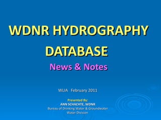
- 1. WDNR HYDROGRAPHY DATABASE News & Notes WLIA February 2011 Presented By: ANN SCHACHTE, WDNR Bureau of Drinking Water & Groundwater Water Division
Editor's Notes
- Junctions: allow two or more lines to connect and facilitate the transfer of flow between them Subtypes: headwater stream confluences shoreline intersections main drain drain leaving state lake inlet or lake outlet
- Ways in which we are using the data to support business needs.
- Developed by taking advantage of work done through the Aquatic GAP project by our DNR Fisheries Research and USGS Natural Communities map developed based on predicted temp/flow data for stream reaches. Natural Communities are used to help identify what uses the water body is capable of supporting. Developed at 1:100,000 scale (NHD) * HYDRO team – conflated 100K GAP attributes to WDNR 24K hydro * Plan is to run GAP models on WDNR 24K hydro to get a true 24K version Two factors are considered in the establishment of a classification for rivers and streams: temperature and stream flow thresholds and ranges that relate to specific “natural communities.” two parameters to use in classification: the maximum daily mean water temperature and the annual 90% exceedence flow. Flow can be estimated within about 10% of their true value with over 75% accuracy using the new GIS-based “stream model” developed jointly with staff from the USGS Aquatic Gap Program and the Michigan and Illinois DNR. The goal of the Great Lakes Aquatic GAP Program is to evaluate the biological diversity of aquatic species and their habitats, and to identify gaps in the distribution and protection of these species and their habitats within the Great Lakes basin. This model incorporates information on climate, geology, topography, and land-use to predict water temperature and flow values for all the stream reaches in the state.
- Lakes Program participates in the Midwest Glacial Lakes Partnership Protects, restores, enhances fish and aquatic communities thru partnerships Use GIS to help target lakes for restoration, enhancement Lakeshed development process use DNR hydro 30 M DEM Model builder in-lake catchment = the actual waterbody area (see Lake Lucerne in wbp_northarea.shp) local catchment = catchment for direct drainage into one lake. The local catchment includes the lake area. see lucerne_local.shp direct catchment = local catchment excluding lake area. see lucerne_direct_temp.shp (from a quick union operation) tributary catchment = includes catchments that trace along the stream network upstream of the inlet(s) to the receiving lake that the trace starts from. The upstream catchments include the lake areas of any upstream lakes. The tributary catchment excludes the local catchment of the receiving lake. Lake Lucerne has 3 inlets and 1 upstream lake. see lucerne_trib.shp
- Working with USGS to evaluate workload to consolidate WDNR hydro and NHD