SlideShare une entreprise Scribd logo
1  sur  24
Source:  http://autodesk.blogs.com/between_the_lines/autocad-release-history.html Source:  http://www.gisuser.com/content/view/11991/53/ Source:  http://www.esri.com/news/arcnews/winter0001articles/anewworld.html Source:  http://store.autodesk.com/store/adsk/en_US/buy/productID.226491200 Source:  http://store.esri.com/esri/search.cfm?SID=2& Source:  http://map3d.wordpress.com/2010/08/09/a-history-class/ Arc/Info R1 released Arc/Info R2 released –  17 systems in use Arc/Info R3 released Arc/Info R4 released Arc/Info R5 released Arc/Info R6 released –  7000+ seats in use ArcView is released – “affordable” desktop GIS Arc/Info R7 & ArcView 2 released 100,000 user seats – ArcView Arcnfo price $10K Arc/Info 8 &  ArcView 3.2  released 500,000+ user seats ArcGIS 8.1 released ArcGIS desktop 9.1 released ArcGIS desktop 9.3 ArcGIS desktop 10 AutoCAD v1.0 AutoCAD v2.0 AutoCAD v2.5 AutoCAD R10 AutoCAD R11 AutoCAD R12 AutoCAD Map released price $4,495 AutoCAD R14 AutoCAD R2000 AutoCAD R2002 COGO tools & annotation AutoCAD R2006 AutoCAD R2008 AutoCAD R2011 ESRI GIS Software Release Timeline Autodesk Software Release Timeline Sold 40,000 packages by 1985 ArcView 10 starting at $1,500 2012 Civil 3D package starting at $3,495 PC Arc/Info released - $4,500 AutoCAD R13 2010 2007 2005 2001 1999 1997 1996 1994 1992 1990 1988 1986 1984 1982                             2010 2007 2005 2001 1999 1997 1994 1993 1991 1989 1987 1985 1983 1981
GIS Milestones Transition from CAD-based map to GIS-based map ,[object Object],[object Object],[object Object]
CAD to ESRI Geodatabase General process, considerations, tips & tricks
Document CAD data ,[object Object],[object Object],[object Object],[object Object],[object Object],[object Object]
[object Object],[object Object]
Tools Used ,[object Object],[object Object],[object Object],[object Object],[object Object],[object Object],[object Object]
CAD lines for highway shields and other symbology are unneeded in the geodatabase Example 1:
Example 2: Do not convert these lines.  Use geodatabase annotation properties
Example 3: Do not convert these lines.  Use geodatabase point feature
CAD lines that will form polygon feature classes need to be inspected closely for gaps Example 1: PLSS lines    Polygons
Mtext is a problem
Mtext does not convert to GDB
Exploded Mtext…. Converts to single GDB annotations
Fix misalignment of stacked lines with the Integrate tool Gap Double section lines Integrate tool with .5 foot cluster tolerance will make these lines coincident.
Attribution techniques ,[object Object],[object Object],[object Object],[object Object]
Buffer + Spatial Join
Attribute Transfer Mapping
2 Spatial join methods 1) Count field shows number of points within poly 2) Poly receives attributes of closest point.  Distance = 0 indicates the point is within the poly boundary.
Join for Count catches errors
Spatial join for attributes produces some erroneous attributes
Spatial join for attributes: distance > 0 indicates either non-parcel polygons or errors.
Watch out for crazy stuff!! Original CAD Converted using Import from CAD tool Converted using Select    Export
More crazy stuff  ,[object Object],[object Object]
The End

Contenu connexe

Tendances

Automated Bulk Conversion of 250,000+ CAD and Corresponding Raster Files to PDF
Automated Bulk Conversion of 250,000+ CAD and Corresponding Raster Files to PDFAutomated Bulk Conversion of 250,000+ CAD and Corresponding Raster Files to PDF
Automated Bulk Conversion of 250,000+ CAD and Corresponding Raster Files to PDFSafe Software
 
ArcGIS Data Interoperability: Tips for LiDAR, 3D, and BIM
ArcGIS Data Interoperability: Tips for LiDAR, 3D, and BIMArcGIS Data Interoperability: Tips for LiDAR, 3D, and BIM
ArcGIS Data Interoperability: Tips for LiDAR, 3D, and BIMSafe Software
 
5 Tips for Integrating CAD Data with Esri ArcGIS
5 Tips for Integrating CAD Data with Esri ArcGIS5 Tips for Integrating CAD Data with Esri ArcGIS
5 Tips for Integrating CAD Data with Esri ArcGISSafe Software
 
Using FME to Support Asset Management
Using FME to Support Asset ManagementUsing FME to Support Asset Management
Using FME to Support Asset ManagementSafe Software
 
GIS/CAD workflows with FME
GIS/CAD workflows with FMEGIS/CAD workflows with FME
GIS/CAD workflows with FMESafe Software
 
Presentation of College Projects Slide Show
Presentation of College Projects Slide ShowPresentation of College Projects Slide Show
Presentation of College Projects Slide ShowSean O Brien
 
Using FME to Validate CAD File Submittals for Utilities
Using FME to Validate CAD File Submittals for UtilitiesUsing FME to Validate CAD File Submittals for Utilities
Using FME to Validate CAD File Submittals for UtilitiesSafe Software
 
Bridging Between CAD & GIS: 8 Ways to Automate Data Integration
Bridging Between CAD & GIS: 8 Ways to Automate Data IntegrationBridging Between CAD & GIS: 8 Ways to Automate Data Integration
Bridging Between CAD & GIS: 8 Ways to Automate Data IntegrationSafe Software
 
Advanced Data Interoperability: LiDAR, 3D, and BIM - Esri UC 2015
Advanced Data Interoperability:LiDAR, 3D, and BIM - Esri UC 2015Advanced Data Interoperability:LiDAR, 3D, and BIM - Esri UC 2015
Advanced Data Interoperability: LiDAR, 3D, and BIM - Esri UC 2015Safe Software
 
Detecting Buildings in AHN2 LiDAR data with ArcGIS - Grontmij
Detecting Buildings in AHN2 LiDAR data with ArcGIS - GrontmijDetecting Buildings in AHN2 LiDAR data with ArcGIS - Grontmij
Detecting Buildings in AHN2 LiDAR data with ArcGIS - GrontmijXander Bakker
 
How to Exchange Data between CAD and GIS
How to Exchange Data between CAD and GISHow to Exchange Data between CAD and GIS
How to Exchange Data between CAD and GISSafe Software
 
From Outdoor to Indoor: 3D and Venue Mapping – FME Summer Camp
From Outdoor to Indoor: 3D and Venue Mapping – FME Summer CampFrom Outdoor to Indoor: 3D and Venue Mapping – FME Summer Camp
From Outdoor to Indoor: 3D and Venue Mapping – FME Summer CampSafe Software
 
Arc2Earth - ESRI NYC Dev Meetup
Arc2Earth - ESRI NYC Dev MeetupArc2Earth - ESRI NYC Dev Meetup
Arc2Earth - ESRI NYC Dev MeetupArc2Earth
 
GIS - CAD Data Integration
GIS - CAD Data Integration GIS - CAD Data Integration
GIS - CAD Data Integration Safe Software
 
Concatenate two different_attribute_fields_in_arc_gis
Concatenate two different_attribute_fields_in_arc_gisConcatenate two different_attribute_fields_in_arc_gis
Concatenate two different_attribute_fields_in_arc_gisAshok Peddi
 
The 'right' choices in GIS - Grontmij
The 'right' choices in GIS - GrontmijThe 'right' choices in GIS - Grontmij
The 'right' choices in GIS - GrontmijXander Bakker
 
How to Automate CAD & GIS Integration
How to Automate CAD & GIS IntegrationHow to Automate CAD & GIS Integration
How to Automate CAD & GIS IntegrationSafe Software
 
How to Overcome 7 Top AutoCAD Road 'Blocks'
How to Overcome 7 Top AutoCAD Road 'Blocks'How to Overcome 7 Top AutoCAD Road 'Blocks'
How to Overcome 7 Top AutoCAD Road 'Blocks'Safe Software
 
Cakefest 2011 - pecha kucha talk abstraction
Cakefest 2011 - pecha kucha talk abstractionCakefest 2011 - pecha kucha talk abstraction
Cakefest 2011 - pecha kucha talk abstractionCarl Sutton
 

Tendances (20)

Automated Bulk Conversion of 250,000+ CAD and Corresponding Raster Files to PDF
Automated Bulk Conversion of 250,000+ CAD and Corresponding Raster Files to PDFAutomated Bulk Conversion of 250,000+ CAD and Corresponding Raster Files to PDF
Automated Bulk Conversion of 250,000+ CAD and Corresponding Raster Files to PDF
 
ArcGIS Data Interoperability: Tips for LiDAR, 3D, and BIM
ArcGIS Data Interoperability: Tips for LiDAR, 3D, and BIMArcGIS Data Interoperability: Tips for LiDAR, 3D, and BIM
ArcGIS Data Interoperability: Tips for LiDAR, 3D, and BIM
 
5 Tips for Integrating CAD Data with Esri ArcGIS
5 Tips for Integrating CAD Data with Esri ArcGIS5 Tips for Integrating CAD Data with Esri ArcGIS
5 Tips for Integrating CAD Data with Esri ArcGIS
 
Using FME to Support Asset Management
Using FME to Support Asset ManagementUsing FME to Support Asset Management
Using FME to Support Asset Management
 
Autocad Basics
Autocad BasicsAutocad Basics
Autocad Basics
 
GIS/CAD workflows with FME
GIS/CAD workflows with FMEGIS/CAD workflows with FME
GIS/CAD workflows with FME
 
Presentation of College Projects Slide Show
Presentation of College Projects Slide ShowPresentation of College Projects Slide Show
Presentation of College Projects Slide Show
 
Using FME to Validate CAD File Submittals for Utilities
Using FME to Validate CAD File Submittals for UtilitiesUsing FME to Validate CAD File Submittals for Utilities
Using FME to Validate CAD File Submittals for Utilities
 
Bridging Between CAD & GIS: 8 Ways to Automate Data Integration
Bridging Between CAD & GIS: 8 Ways to Automate Data IntegrationBridging Between CAD & GIS: 8 Ways to Automate Data Integration
Bridging Between CAD & GIS: 8 Ways to Automate Data Integration
 
Advanced Data Interoperability: LiDAR, 3D, and BIM - Esri UC 2015
Advanced Data Interoperability:LiDAR, 3D, and BIM - Esri UC 2015Advanced Data Interoperability:LiDAR, 3D, and BIM - Esri UC 2015
Advanced Data Interoperability: LiDAR, 3D, and BIM - Esri UC 2015
 
Detecting Buildings in AHN2 LiDAR data with ArcGIS - Grontmij
Detecting Buildings in AHN2 LiDAR data with ArcGIS - GrontmijDetecting Buildings in AHN2 LiDAR data with ArcGIS - Grontmij
Detecting Buildings in AHN2 LiDAR data with ArcGIS - Grontmij
 
How to Exchange Data between CAD and GIS
How to Exchange Data between CAD and GISHow to Exchange Data between CAD and GIS
How to Exchange Data between CAD and GIS
 
From Outdoor to Indoor: 3D and Venue Mapping – FME Summer Camp
From Outdoor to Indoor: 3D and Venue Mapping – FME Summer CampFrom Outdoor to Indoor: 3D and Venue Mapping – FME Summer Camp
From Outdoor to Indoor: 3D and Venue Mapping – FME Summer Camp
 
Arc2Earth - ESRI NYC Dev Meetup
Arc2Earth - ESRI NYC Dev MeetupArc2Earth - ESRI NYC Dev Meetup
Arc2Earth - ESRI NYC Dev Meetup
 
GIS - CAD Data Integration
GIS - CAD Data Integration GIS - CAD Data Integration
GIS - CAD Data Integration
 
Concatenate two different_attribute_fields_in_arc_gis
Concatenate two different_attribute_fields_in_arc_gisConcatenate two different_attribute_fields_in_arc_gis
Concatenate two different_attribute_fields_in_arc_gis
 
The 'right' choices in GIS - Grontmij
The 'right' choices in GIS - GrontmijThe 'right' choices in GIS - Grontmij
The 'right' choices in GIS - Grontmij
 
How to Automate CAD & GIS Integration
How to Automate CAD & GIS IntegrationHow to Automate CAD & GIS Integration
How to Automate CAD & GIS Integration
 
How to Overcome 7 Top AutoCAD Road 'Blocks'
How to Overcome 7 Top AutoCAD Road 'Blocks'How to Overcome 7 Top AutoCAD Road 'Blocks'
How to Overcome 7 Top AutoCAD Road 'Blocks'
 
Cakefest 2011 - pecha kucha talk abstraction
Cakefest 2011 - pecha kucha talk abstractionCakefest 2011 - pecha kucha talk abstraction
Cakefest 2011 - pecha kucha talk abstraction
 

Similaire à GIS and CAD Software Release Timeline Comparison

Bridging Between CAD & GIS: 8 Ways to Automate Data Integration
Bridging Between CAD & GIS: 8 Ways to Automate Data IntegrationBridging Between CAD & GIS: 8 Ways to Automate Data Integration
Bridging Between CAD & GIS: 8 Ways to Automate Data IntegrationSafe Software
 
Bridging Between CAD & GIS: 8 Ways to Automate Your Data Integration
Bridging Between CAD & GIS: 8 Ways to Automate Your Data IntegrationBridging Between CAD & GIS: 8 Ways to Automate Your Data Integration
Bridging Between CAD & GIS: 8 Ways to Automate Your Data IntegrationSafe Software
 
CAD-GIS Integration Approaches with ARCGIS
CAD-GIS Integration Approaches with ARCGIS CAD-GIS Integration Approaches with ARCGIS
CAD-GIS Integration Approaches with ARCGIS Andrew Bashfield
 
GIS and CAD Integration: The Bentley Perspective
GIS and CAD Integration: The Bentley PerspectiveGIS and CAD Integration: The Bentley Perspective
GIS and CAD Integration: The Bentley PerspectiveAndrew Bashfield
 
Bridging Between CAD & GIS: 6 Ways to Automate Your Data Integration
Bridging Between  CAD & GIS: 6 Ways to Automate Your  Data IntegrationBridging Between  CAD & GIS: 6 Ways to Automate Your  Data Integration
Bridging Between CAD & GIS: 6 Ways to Automate Your Data IntegrationSafe Software
 
Bridging Between CAD & GIS: 6 Ways to Automate Your Data Integration
Bridging Between CAD & GIS: 6 Ways to Automate Your Data IntegrationBridging Between CAD & GIS: 6 Ways to Automate Your Data Integration
Bridging Between CAD & GIS: 6 Ways to Automate Your Data Integrationmarketing932765
 
Bridging Between CAD & GIS: 6 Ways to Automate Your Data Integration
Bridging Between CAD & GIS:  6 Ways to Automate Your Data IntegrationBridging Between CAD & GIS:  6 Ways to Automate Your Data Integration
Bridging Between CAD & GIS: 6 Ways to Automate Your Data Integrationmarketing932765
 
Let's integrate CAD/BIM/GIS on the same platform: A practical approach in rea...
Let's integrate CAD/BIM/GIS on the same platform: A practical approach in rea...Let's integrate CAD/BIM/GIS on the same platform: A practical approach in rea...
Let's integrate CAD/BIM/GIS on the same platform: A practical approach in rea...SANGHEE SHIN
 
Introduction To Geometry Shaders
Introduction To Geometry ShadersIntroduction To Geometry Shaders
Introduction To Geometry Shaderspjcozzi
 
Getting to Know ArcGIS Pro
Getting to Know ArcGIS ProGetting to Know ArcGIS Pro
Getting to Know ArcGIS ProEsri UK
 
2016 workshops: understanding the language of gis and cad by warren geissler
2016 workshops:  understanding  the language  of gis and cad by warren geissler2016 workshops:  understanding  the language  of gis and cad by warren geissler
2016 workshops: understanding the language of gis and cad by warren geisslerGIS in the Rockies
 
CAD STANDARDS - SMART MANUFACTURING MECH
CAD STANDARDS - SMART MANUFACTURING MECHCAD STANDARDS - SMART MANUFACTURING MECH
CAD STANDARDS - SMART MANUFACTURING MECHRAJESHS631800
 
mago3D FOSS4G NA 2018
mago3D FOSS4G NA 2018mago3D FOSS4G NA 2018
mago3D FOSS4G NA 2018정대 천
 
Graphics Standards and Algorithm
Graphics Standards and AlgorithmGraphics Standards and Algorithm
Graphics Standards and AlgorithmYatin Singh
 
What's new in Hexagon-Geospatial Power Portfolio 2016
What's new in Hexagon-Geospatial Power Portfolio 2016What's new in Hexagon-Geospatial Power Portfolio 2016
What's new in Hexagon-Geospatial Power Portfolio 2016Planetek Italia Srl
 
Dev Summit 2011 - Talk
Dev Summit 2011 - TalkDev Summit 2011 - Talk
Dev Summit 2011 - TalkArc2Earth
 
NDGISUC2017 - Introducing ArcGIS Pro
NDGISUC2017 - Introducing ArcGIS ProNDGISUC2017 - Introducing ArcGIS Pro
NDGISUC2017 - Introducing ArcGIS ProNorth Dakota GIS Hub
 
GIS to CAD Translations for a Gas Pipline
GIS to CAD Translations for a Gas PiplineGIS to CAD Translations for a Gas Pipline
GIS to CAD Translations for a Gas PiplineWarren Newhauser
 
Extending 3D Model Visualization with FME 2017
Extending 3D Model Visualization with FME 2017Extending 3D Model Visualization with FME 2017
Extending 3D Model Visualization with FME 2017Safe Software
 

Similaire à GIS and CAD Software Release Timeline Comparison (20)

Bridging Between CAD & GIS: 8 Ways to Automate Data Integration
Bridging Between CAD & GIS: 8 Ways to Automate Data IntegrationBridging Between CAD & GIS: 8 Ways to Automate Data Integration
Bridging Between CAD & GIS: 8 Ways to Automate Data Integration
 
Bridging Between CAD & GIS: 8 Ways to Automate Your Data Integration
Bridging Between CAD & GIS: 8 Ways to Automate Your Data IntegrationBridging Between CAD & GIS: 8 Ways to Automate Your Data Integration
Bridging Between CAD & GIS: 8 Ways to Automate Your Data Integration
 
CAD-GIS Integration Approaches with ARCGIS
CAD-GIS Integration Approaches with ARCGIS CAD-GIS Integration Approaches with ARCGIS
CAD-GIS Integration Approaches with ARCGIS
 
GIS and CAD Integration: The Bentley Perspective
GIS and CAD Integration: The Bentley PerspectiveGIS and CAD Integration: The Bentley Perspective
GIS and CAD Integration: The Bentley Perspective
 
Bridging Between CAD & GIS: 6 Ways to Automate Your Data Integration
Bridging Between  CAD & GIS: 6 Ways to Automate Your  Data IntegrationBridging Between  CAD & GIS: 6 Ways to Automate Your  Data Integration
Bridging Between CAD & GIS: 6 Ways to Automate Your Data Integration
 
Bridging Between CAD & GIS: 6 Ways to Automate Your Data Integration
Bridging Between CAD & GIS: 6 Ways to Automate Your Data IntegrationBridging Between CAD & GIS: 6 Ways to Automate Your Data Integration
Bridging Between CAD & GIS: 6 Ways to Automate Your Data Integration
 
Bridging Between CAD & GIS: 6 Ways to Automate Your Data Integration
Bridging Between CAD & GIS:  6 Ways to Automate Your Data IntegrationBridging Between CAD & GIS:  6 Ways to Automate Your Data Integration
Bridging Between CAD & GIS: 6 Ways to Automate Your Data Integration
 
Let's integrate CAD/BIM/GIS on the same platform: A practical approach in rea...
Let's integrate CAD/BIM/GIS on the same platform: A practical approach in rea...Let's integrate CAD/BIM/GIS on the same platform: A practical approach in rea...
Let's integrate CAD/BIM/GIS on the same platform: A practical approach in rea...
 
Introduction To Geometry Shaders
Introduction To Geometry ShadersIntroduction To Geometry Shaders
Introduction To Geometry Shaders
 
Getting to Know ArcGIS Pro
Getting to Know ArcGIS ProGetting to Know ArcGIS Pro
Getting to Know ArcGIS Pro
 
2016 workshops: understanding the language of gis and cad by warren geissler
2016 workshops:  understanding  the language  of gis and cad by warren geissler2016 workshops:  understanding  the language  of gis and cad by warren geissler
2016 workshops: understanding the language of gis and cad by warren geissler
 
GIS & CAD
GIS & CADGIS & CAD
GIS & CAD
 
CAD STANDARDS - SMART MANUFACTURING MECH
CAD STANDARDS - SMART MANUFACTURING MECHCAD STANDARDS - SMART MANUFACTURING MECH
CAD STANDARDS - SMART MANUFACTURING MECH
 
mago3D FOSS4G NA 2018
mago3D FOSS4G NA 2018mago3D FOSS4G NA 2018
mago3D FOSS4G NA 2018
 
Graphics Standards and Algorithm
Graphics Standards and AlgorithmGraphics Standards and Algorithm
Graphics Standards and Algorithm
 
What's new in Hexagon-Geospatial Power Portfolio 2016
What's new in Hexagon-Geospatial Power Portfolio 2016What's new in Hexagon-Geospatial Power Portfolio 2016
What's new in Hexagon-Geospatial Power Portfolio 2016
 
Dev Summit 2011 - Talk
Dev Summit 2011 - TalkDev Summit 2011 - Talk
Dev Summit 2011 - Talk
 
NDGISUC2017 - Introducing ArcGIS Pro
NDGISUC2017 - Introducing ArcGIS ProNDGISUC2017 - Introducing ArcGIS Pro
NDGISUC2017 - Introducing ArcGIS Pro
 
GIS to CAD Translations for a Gas Pipline
GIS to CAD Translations for a Gas PiplineGIS to CAD Translations for a Gas Pipline
GIS to CAD Translations for a Gas Pipline
 
Extending 3D Model Visualization with FME 2017
Extending 3D Model Visualization with FME 2017Extending 3D Model Visualization with FME 2017
Extending 3D Model Visualization with FME 2017
 

Plus de Wisconsin Land Information Association

Workshop using open source software for mobile data collection workshop - a...
Workshop   using open source software for mobile data collection workshop - a...Workshop   using open source software for mobile data collection workshop - a...
Workshop using open source software for mobile data collection workshop - a...Wisconsin Land Information Association
 
Mapping spatial patterns of whai finder usage to measure community outreach e...
Mapping spatial patterns of whai finder usage to measure community outreach e...Mapping spatial patterns of whai finder usage to measure community outreach e...
Mapping spatial patterns of whai finder usage to measure community outreach e...Wisconsin Land Information Association
 
Lakesheds and riverscapes extending wisconsin's hydro database with landsca...
Lakesheds and riverscapes   extending wisconsin's hydro database with landsca...Lakesheds and riverscapes   extending wisconsin's hydro database with landsca...
Lakesheds and riverscapes extending wisconsin's hydro database with landsca...Wisconsin Land Information Association
 
Lake habitat mapping with side scan sonar in nine wisconsin lakes - christine...
Lake habitat mapping with side scan sonar in nine wisconsin lakes - christine...Lake habitat mapping with side scan sonar in nine wisconsin lakes - christine...
Lake habitat mapping with side scan sonar in nine wisconsin lakes - christine...Wisconsin Land Information Association
 
Integrating sanitary televising data with utility gis data within the city of...
Integrating sanitary televising data with utility gis data within the city of...Integrating sanitary televising data with utility gis data within the city of...
Integrating sanitary televising data with utility gis data within the city of...Wisconsin Land Information Association
 
Integrating high accuracy gps with esri's arc gis for windows mobile field so...
Integrating high accuracy gps with esri's arc gis for windows mobile field so...Integrating high accuracy gps with esri's arc gis for windows mobile field so...
Integrating high accuracy gps with esri's arc gis for windows mobile field so...Wisconsin Land Information Association
 
Implementing arc gis 10.1 for the wisconsin dnr nhi portal levi felling
Implementing arc gis 10.1 for the wisconsin dnr nhi portal   levi fellingImplementing arc gis 10.1 for the wisconsin dnr nhi portal   levi felling
Implementing arc gis 10.1 for the wisconsin dnr nhi portal levi fellingWisconsin Land Information Association
 

Plus de Wisconsin Land Information Association (20)

Airphoto anomilies
Airphoto anomiliesAirphoto anomilies
Airphoto anomilies
 
A wikimap of landscape values in the bad river watershed carl sack
A wikimap of landscape values in the bad river watershed   carl sackA wikimap of landscape values in the bad river watershed   carl sack
A wikimap of landscape values in the bad river watershed carl sack
 
Workshop using open source software for mobile data collection workshop - a...
Workshop   using open source software for mobile data collection workshop - a...Workshop   using open source software for mobile data collection workshop - a...
Workshop using open source software for mobile data collection workshop - a...
 
Wigicc's role in wisconsin jon schwitchtenberg
Wigicc's role in wisconsin   jon schwitchtenbergWigicc's role in wisconsin   jon schwitchtenberg
Wigicc's role in wisconsin jon schwitchtenberg
 
Wi 590 nutrient management web application lisa morrison
Wi 590 nutrient management web application   lisa morrisonWi 590 nutrient management web application   lisa morrison
Wi 590 nutrient management web application lisa morrison
 
Surveying and land records management dean roth
Surveying and land records management   dean rothSurveying and land records management   dean roth
Surveying and land records management dean roth
 
Mapping spatial patterns of whai finder usage to measure community outreach e...
Mapping spatial patterns of whai finder usage to measure community outreach e...Mapping spatial patterns of whai finder usage to measure community outreach e...
Mapping spatial patterns of whai finder usage to measure community outreach e...
 
Local gis in the statewide voter registration system sarah whitt
Local gis in the statewide voter registration system   sarah whittLocal gis in the statewide voter registration system   sarah whitt
Local gis in the statewide voter registration system sarah whitt
 
Li dar quality control a client's perspective - tyler grosshuesch
Li dar quality control   a client's perspective - tyler grosshueschLi dar quality control   a client's perspective - tyler grosshuesch
Li dar quality control a client's perspective - tyler grosshuesch
 
Li dar meets wisconsinview jc nelson
Li dar meets wisconsinview   jc nelsonLi dar meets wisconsinview   jc nelson
Li dar meets wisconsinview jc nelson
 
Lakesheds and riverscapes extending wisconsin's hydro database with landsca...
Lakesheds and riverscapes   extending wisconsin's hydro database with landsca...Lakesheds and riverscapes   extending wisconsin's hydro database with landsca...
Lakesheds and riverscapes extending wisconsin's hydro database with landsca...
 
Lake habitat mapping with side scan sonar in nine wisconsin lakes - christine...
Lake habitat mapping with side scan sonar in nine wisconsin lakes - christine...Lake habitat mapping with side scan sonar in nine wisconsin lakes - christine...
Lake habitat mapping with side scan sonar in nine wisconsin lakes - christine...
 
Integrative mapping strategies jeremy bixby
Integrative mapping strategies   jeremy bixbyIntegrative mapping strategies   jeremy bixby
Integrative mapping strategies jeremy bixby
 
Integrating sanitary televising data with utility gis data within the city of...
Integrating sanitary televising data with utility gis data within the city of...Integrating sanitary televising data with utility gis data within the city of...
Integrating sanitary televising data with utility gis data within the city of...
 
Integrating high accuracy gps with esri's arc gis for windows mobile field so...
Integrating high accuracy gps with esri's arc gis for windows mobile field so...Integrating high accuracy gps with esri's arc gis for windows mobile field so...
Integrating high accuracy gps with esri's arc gis for windows mobile field so...
 
Implementing arc gis 10.1 for the wisconsin dnr nhi portal levi felling
Implementing arc gis 10.1 for the wisconsin dnr nhi portal   levi fellingImplementing arc gis 10.1 for the wisconsin dnr nhi portal   levi felling
Implementing arc gis 10.1 for the wisconsin dnr nhi portal levi felling
 
Gis in parks and recreation the proragis website - trish nau
Gis in parks and recreation   the proragis website - trish nauGis in parks and recreation   the proragis website - trish nau
Gis in parks and recreation the proragis website - trish nau
 
Geo moose project update brian fischer
Geo moose project update   brian fischerGeo moose project update   brian fischer
Geo moose project update brian fischer
 
Elevation hydrology tools kent pena
Elevation hydrology tools   kent penaElevation hydrology tools   kent pena
Elevation hydrology tools kent pena
 
Developing mobile apps pick your poison - levi felling
Developing mobile apps   pick your poison - levi fellingDeveloping mobile apps   pick your poison - levi felling
Developing mobile apps pick your poison - levi felling
 

GIS and CAD Software Release Timeline Comparison

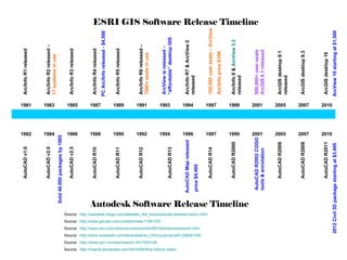
  • 1. Source: http://autodesk.blogs.com/between_the_lines/autocad-release-history.html Source: http://www.gisuser.com/content/view/11991/53/ Source: http://www.esri.com/news/arcnews/winter0001articles/anewworld.html Source: http://store.autodesk.com/store/adsk/en_US/buy/productID.226491200 Source: http://store.esri.com/esri/search.cfm?SID=2& Source: http://map3d.wordpress.com/2010/08/09/a-history-class/ Arc/Info R1 released Arc/Info R2 released – 17 systems in use Arc/Info R3 released Arc/Info R4 released Arc/Info R5 released Arc/Info R6 released – 7000+ seats in use ArcView is released – “affordable” desktop GIS Arc/Info R7 & ArcView 2 released 100,000 user seats – ArcView Arcnfo price $10K Arc/Info 8 & ArcView 3.2 released 500,000+ user seats ArcGIS 8.1 released ArcGIS desktop 9.1 released ArcGIS desktop 9.3 ArcGIS desktop 10 AutoCAD v1.0 AutoCAD v2.0 AutoCAD v2.5 AutoCAD R10 AutoCAD R11 AutoCAD R12 AutoCAD Map released price $4,495 AutoCAD R14 AutoCAD R2000 AutoCAD R2002 COGO tools & annotation AutoCAD R2006 AutoCAD R2008 AutoCAD R2011 ESRI GIS Software Release Timeline Autodesk Software Release Timeline Sold 40,000 packages by 1985 ArcView 10 starting at $1,500 2012 Civil 3D package starting at $3,495 PC Arc/Info released - $4,500 AutoCAD R13 2010 2007 2005 2001 1999 1997 1996 1994 1992 1990 1988 1986 1984 1982                             2010 2007 2005 2001 1999 1997 1994 1993 1991 1989 1987 1985 1983 1981
  • 2.
  • 3. CAD to ESRI Geodatabase General process, considerations, tips & tricks
  • 4.
  • 5.
  • 6.
  • 7. CAD lines for highway shields and other symbology are unneeded in the geodatabase Example 1:
  • 8. Example 2: Do not convert these lines. Use geodatabase annotation properties
  • 9. Example 3: Do not convert these lines. Use geodatabase point feature
  • 10. CAD lines that will form polygon feature classes need to be inspected closely for gaps Example 1: PLSS lines  Polygons
  • 11. Mtext is a problem
  • 12. Mtext does not convert to GDB
  • 13. Exploded Mtext…. Converts to single GDB annotations
  • 14. Fix misalignment of stacked lines with the Integrate tool Gap Double section lines Integrate tool with .5 foot cluster tolerance will make these lines coincident.
  • 15.
  • 18. 2 Spatial join methods 1) Count field shows number of points within poly 2) Poly receives attributes of closest point. Distance = 0 indicates the point is within the poly boundary.
  • 19. Join for Count catches errors
  • 20. Spatial join for attributes produces some erroneous attributes
  • 21. Spatial join for attributes: distance > 0 indicates either non-parcel polygons or errors.
  • 22. Watch out for crazy stuff!! Original CAD Converted using Import from CAD tool Converted using Select  Export
  • 23.