1. EERI Special Earthquake Report — May 2010
Learning from Earthquakes
The Mw 7.0 Haiti Earthquake of January 12, 2010: Report #2
This second insert on the Haiti
earthquake covers engineering
failures and the social impacts of
the quake. The first report in the
April issue covered seismology
and geotechnical aspects, primarily. The EERI team responsible for
this report, including members from
partnering organizations — the Network for Earthquake Engineering
Simulation, the Mid-America Earthquake Center, Florida International
University, Sherbrooke University,
University of Delaware’s Disaster
Research Center and Western
Washington University’s Resilience
Institute — visited Haiti from February 28 through March 7, 2010.
The 18-member multi-disciplinary
team included engineers, social
scientists, city planners, architects,
and geographers. The EERI team
worked with the ASCE Technical
Council on Lifeline Earthquake
Engineering team and, together,
the teams visited over 500 facilities and buildings in the heavily hit
areas of Port-au-Prince, Léogâne,
Petit Goâve, and Jacmel. The EERI
team and its partners consisted of
Reginald DesRoches, Georgia Institute of Technology (team leader);
Susan Brink, University of Delaware; Peter Coats, Simpson Gumpertz & Heger; Amr Elnashi, MidAmerica Earthquake Center; Harley
Etienne, Georgia Institute of Technology; Rebekah Green, Western
Washington University; Martin
Hammer, architect, Berkeley, California; Charles Huyck, ImageCat;
Ayhan Irfanoglu, Purdue University
& NEEScomm; Sylvan Jolibois,
Florida International University;
Anna Lang, University of California,
San Diego; Amanda Lewis, MidAmerica Earthquake Center; JeanRobert Michaud, Boeing; Scott
Miles, Western Washington University; Rob Olshansky, University of
Illinois; and Patrick Paultre, Sherbrooke University.
The ASCE TCLEE team included
Curt Edwards, Psomas, (team leader); Pierre Alex Augustin, State of
California; Don Ballantyne, MMI; Bill
Bruin, Halcrow; Rick Carter, State of
Oregon; Brucely Joseph, URS Corp;
Aimee Lavarnway, Shannon Wilson;
Nason McCullough, CH2M Hill; Mark
Pickett, University of Toledo; Dave
Plum, URS Corp; and Stu Werner,
Seismic Systems & Engineering.
This report is made possible by
support to EERI provided by the
National Science Foundation under
award #CMMI-0758529.
Introduction
On January 12, 2010, at approximately 5 p.m. local time, an Mw=7.0 earthquake struck approximately 17 km
west of Port-au-Prince, Haiti, along
the Enriquillo fault. The effects of the
earthquake were felt over a wide
area, including the provinces
(known as departments) of Ouest,
Sud-Est, and Nippes. The metropolitan Port-au-Prince region, which
includes the cities of Carrefour,
Petionville, Delmas, Tabarre, Cite
Soleil, and Kenscoff. was hit extremely hard. In the city of Léogâne, located on the epicenter,
80% of the buildings collapsed or
were critically damaged.
Over 1.5 million people (approximately 15% of the national population) have been directly affected by
the earthquake. The Haitian government estimates over 220,000
people lost their lives and more
than 300,000 were injured in the
earthquake. It is estimated that over
105,000 homes were completely
destroyed and more than 208,000
damaged. Approximately 1,300
educational institutions and over 50
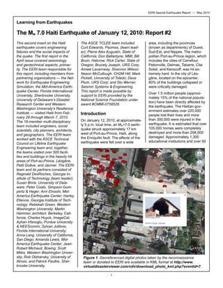
Figure 1. Georeferenced digital photos taken by the reconnaissance
team or donated to EERI are available in KML format at http://www.
virtualdisasterviewer.com/vdv/download_photo_kml.php?eventid=7.
1
2. EERI Special Earthquake Report — May 2010
medical centers and hospitals collapsed or were damaged; 13 out of
15 key government buildings were
severely damaged.
The Haitian government estimates
that the damage caused by the
earthquake totals approximately
$7.8 billion, which is more than
120% of Haiti’s 2009 gross domestic product.
Remote Sensing Data
The Global Earth Observation
Catastrophe Assessment Network
(GEO-CAN) response after the
Haiti earthquake realized a vision
many years in the making — that
rapid and actionable damage assessment could be completed with
remotely sensed data enabled by
distributed interpretation in a geospatial environment. Analysis is
done through a portal that serves
as a “social networking tool” where,
after reading a brief training document, hundreds of engineers and
scientists provided an assessment
of damage by comparing beforeand-after satellite images of the
affected areas. GEO-CAN allowed
for a comprehensive assessment of
regional damage and was used in
the development of the post-disaster needs assessment. It can serve
as a successful model for utilizing
remote sensing technologies after a
regional disaster.
Within a week, close to 30,000
buildings had been identified as
heavily damaged or collapsed.
The data were checked independently using field ground surveys
conducted by a wide range of organizations. In total, there were
over 600 GEO-CAN volunteers
from 23 countries representing 53
private companies, 60 academic
institutions, and 18 government or
nonprofit organizations. Almost 200
members from EERI contributed
significantly to the effort. For a complete list of organizations, visit the
GEO-CAN community tab at http://
www.virtualdisasterviewer.com/
vdv/index.hp?selectedEventId=7.
All data produced have been made
publicly available directly through the
World Bank and served in the Virtual
Disaster Viewer (VDV), alongside
thousands of geo-tagged photographs from the EERI reconnaissance team and various other postdisaster ground field teams (Figure 1).
Many lessons have been learned
from the GEO-CAN effort, among
them that very high-resolution imagery can be used to provide rapid
damage estimates of severely damaged structures where it is difficult to
deploy in the field. This has enormous
implications for future events where
access is restricted or not feasible
and immediate information is required. During reconnaissance, it became clear that more damage was
visible in the imagery than could be
seen on the ground, because damaged structures were behind walls,
deep within blocks. Mobilizing hundreds of engineers requires significant resources. Much of GEO-CAN’s
success is attributable to the generosity of Google, Microsoft, Digital Globe,
and GeoEye and the San Diego State
University Visualization
Center, which not only
freely distributed data,
but actively served imagery for interpretation.
Performance of Historic
Structures
Historic buildings dating from the
time of French colonization to the
1920s predate the concrete-framed
concrete block construction that
comprises most of the building inventory of Port-au-Prince. Historic
buildings fall into three distinct categories: timber frame, unreinforced
masonry (URM), and reinforced
concrete.
Timber Frame: In Port-au-Prince
and other urban areas of Haiti,
these buildings were generally
constructed between 1890 and
1925. Built typically as residences,
the buildings were generally either
1) timber frame with exterior wood
siding, or 2) timber frame with masonry infill (known by the French
term colombage) (Figure 2). The
masonry is either fired brick with
lime mortar, or irregular shaped
limestone with earthen mortar and
a lime plaster finish. In all observed
cases, the timber frame included
diagonal members and interior
Most importantly, GEOCAN is a model for mobilizing volunteers with professional expertise. The
GEO-CAN community
has conclusively demonstrated that professionals
will volunteer in large
numbers if the proper IT
infrastructure is available.
Social-networking can
be used to establish a
framework of massively
distributed but collaborative environments that
can reduce the communication gridlock common
in disasters. Future successful deployments will
hinge upon harnessing
this framework.
2
Figure 2. Timber frame with colombage (photo:
Martin Hammer).
3. EERI Special Earthquake Report — May 2010
Figure 3. Wood frame building next to collapsed concrete and
masonry building (photo: Martin Hammer).
wooden planks horizontally across
the wall framing.
These buildings were either one
story or two, with mortared brick
or limestone foundations, woodframed floors, and corrugated steel
roofs framed with wood. The most
prominent timber frame buildings
exhibit ornate carpentry details,
and are commonly referred to as
“gingerbread,” but many simpler
buildings utilize the same methods
of construction.
Both types of timber frame construction are inherently resistant to
earthquakes. The all-wood buildings are light and flexible, and
utilize the diagonal members and
wood-sheathed walls to resist lateral loads. The colombage buildings are heavier, but dissipate energy through friction between the
masonry panels and the timber
members, and between the masonry units after their weaker mortar
joints fracture. The diagonal wood
members provide resistance as
well (Figure 2).
The timber frame buildings in Portau-Prince, Petionville, and the
south coastal city of Jacmel performed well, and were often seen
adjacent to the site of a collapsed
masonry or concrete structure (Figure 3). However,
many sustained moderate
to serious damage due to Figure 4. Colombage performed well, though
the unreinforced masonry wall collapsed (photo:
the deterioration of wood
members from termites or Martin Hammer).
rot. The colombage buildings sometimes expelled masonry
ing Ministry of Finance (also URM)
panels under out-of-plane loading.
suffered far less damage and did
Additions made of unreinforced
not collapse.
masonry or reinforced concrete
usually suffered the most damage
The failures we observed generally
(Figure 4).
ranged from diagonal cracking in
wall sections to absolute collapse;
Unreinforced Masonry (URM):
modes of failure included 1) lack of
Unreinforced masonry construction
brick ties or brick headers between
predominates among buildings conbrick withes, 2) lack of adequate
structed between the late 1800s and
steel reinforcing, 3) weak stone
the 1920s, often combined with the
masonry where it was necessary
timber construction described above.
for structural support, and 4) poor
The EERI team observed URM resmortar quality due to poor aggreidential, academic, religious, and
gate quality, inadequate cement or
government buildings (Figure 5). The
lime, or poor maintenance.
buildings were a combination of rough
stone masonry and fired clay brick,
with little or no smooth steel reinforcing along building corners or window
and door heads. The stone masonry
appeared to be the light colored
limestone that is commonly acquired
in the La Boule quarries in the hills
around Port-au-Prince. Some URM
buildings, such as the Haitian Ministry of Interior, failed catastrophically
(Figure 5) even though the neighbor3
For those URM buildings that remain intact or that can be salvaged,
it is advisable for an historic preservation and/or structural engineering professional to inspect them in
greater detail to determine appropriate preservation and structural
retrofit measures. These measures
may include doweled through-wall
anchors, parallel lateral bracing, or
repairs to mortar.
4. EERI Special Earthquake Report — May 2010
Simpson, Gumpertz and Heger) revealed that the concrete aggregate
is of relatively high quality and contains approximately 30% volcanic
materials. There is no evidence
that marine aggregate was in either
of these buildings. We observed
excessive corrosion of the steel
reinforcement in both buildings, but
given the results of the petrographic
testing, it appears that it was the result of the carbonation of the aged
concrete rather than the use of poor
aggregate.
Figure 5. Unreinforced masonry Ministry of Interior building (photo: Martin
Hammer).
Reinforced Concrete: Many turnof-the-20th-century structures built
in the manner prevalent in Europe
at the time were precursors to what
is now the most common form of
construction in Haiti. At the time
these were built, it was unique to
construct an entire building with
poured-in-place concrete. This
building type included two of the
best known landmarks in Haiti, the
National Presidential Palace and
the National Cathedral (Figure 6),
both of which collapsed catastrophically.
Each of these buildings had unusual footprints that militated against
any effort to sustain seismic forces.
Each building also included large
concrete domed structures, which
apparently contributed to their collapse. In the case of the National
Presidential Palace, an eyewitness
reported that the second story
rocked until the central core collapsed vertically, followed by the
front section of the east and west
wings. This indicates that the second story acted as the soft story
between the rigid first floor and the
massive concrete dome and roof
structures. The strength and hardness of these domes was evidenced by their showing no apparent cracking after falling one story.
While the National Cathedral did have
a light steel roof structure, it also had
two large concrete domes on top of
its towers, making them top heavy.
In addition to collapses, the damage
that we observed included severe
shear cracks in columns and out-ofplane collapses of concrete walls.
Petrographic testing of concrete from
both samples (services donated by
According to our observations, the
following are possible primary
modes of failure: poor weight and
wall distribution for seismic loading;
corroded steel reinforcement as a
result of aged carbonated concrete;
and inadequately ductile concrete
members to sustain repetitive
stressing.
Engineered Buildings
Given the absence of building
codes and record keeping, and the
widespread practice of uncontrolled
construction, it was not always possible to establish whether a spe-
Figure 6. Collapsed roof, interior of National Cathedral, Port-au-Prince
(photo: Martin Hammer).
4
5. EERI Special Earthquake Report — May 2010
cific building was engineered. We
decided that “modern engineered
buildings” were those with regular
structural framing layouts, estimated to be built after the 1950s, and
deemed to have received some degree of care by a structural engineer during design and construction. “Engineered” does not mean
designed for seismic loading. While
modern commercial, industrial, and
essential buildings are the most
likely structures to be engineered,
several low to mid-rise office, residential, and school buildings were
also considered to be engineered.
Most of the early generation Haitian engineers and architects were
educated in France and were familiar with the French building design
codes (AFNOR). By the 1960-70s,
these engineers were teaching at
the university level using the
French code. Earthquake provisions were not present in these
codes, and moment-resisting
frames were the favored structural
system. A small number of Haitian
engineers were educated and trained
in North America, and were familiar
with the Canadian and U.S. design
codes.
Since the 1950s, reinforced concrete
has been the material of choice and
many construction practices that do
not consider seismic loads were established at that time. Concrete is
usually hand-mixed on site for smaller
engineered buildings and is typically
of poor quality. Lately, in prominent
engineered buildings such as those
at the Digicel compound (Figure 7),
ready-mix concrete is used. There is
only one Haitian contractor who uses
ready-mix concrete consistently; no
information is available about the
practice of international contractors.
In older engineered buildings, smooth
reinforcing bars were used, and
transverse reinforcement was observed to be 5-6mm diameter wires
with unacceptably large spacing, particularly in columns. In newer construction, deformed bars were also
observed. Ductile detailing was absent in the damaged and exposed
structural members in both
older and more recent construction.
In the past, the Ministry of
Public Works controlled
building permits, along with
plan and design reviews,
but the jurisdiction now lies
with municipalities. Local
engineers indicated that
this transfer of jurisdiction
led to reduced control over
design and construction.
Figure 7. The 12-story Digicel building with
RC dual (frame-wall) structural system (photo:
Anna Lang).
Reinforced Concrete
Buildings: Reinforced
concrete buildings with
moment-resisting frame
structural systems (RCMRF) and unreinforced
hollow concrete masonry
unit (CMU) infill walls
dominate the engineered
buildings. A small number
of dual-system buildings
with RC MRF and structural
walls were also observed.
5
The typical floor system is RC slab
with beams. RC dual-systems are
observed to have sustained less
damage, on average, than the
RC-MRF buildings. In several buildings recently constructed, seismic
design guidelines such as those
provided in U.S. design codes and
ACI-318 were followed. However,
the application of seismic design
principles was due to individual initiative and not because of consensus or governmental action.
Critical structural damage was
mainly due to absence of proper
detailing in the structural elements,
with failure of brittle columns as
the main cause of collapse. Some
structures had soft-story issues.
The quality of concrete varied from
weak (typical) to good (rare), verified by preliminary tests. Both
smooth and deformed reinforcing
bars were observed in structural
elements exposed due to damage.
The Digicel building is the tallest
engineered building in Port-auPrince. One of its L-shaped structural walls can be seen along the
left corner in Figure 7. Three such
walls are present at as many corners of the building. The fourth corner has a large atrium with deep
beams. An elevator core wall is
near the atrium corner. The building
performed well with light structural
and some nonstructural damage.
Spalling of concrete was visible in
some columns, top and bottom;
some beams in the upper floors
suffered severe spalling and, in a
few places, buckling of longitudinal
bars. Adjacent three-story RC-MRF
buildings were severely damaged.
In the Petionville area, several
modern engineered buildings were
inspected. One of the hotels, a
RC-MRF with reinforced CMU infill
walls, suffered damage in its infill
walls and a few captive columns
at the ground story (Figures 8 and
9). Another RC-MRF hotel under
construction (with three stories
completed and three more to go)
sustained no damage (Figure 10),
6. EERI Special Earthquake Report — May 2010
Figure 8. Reinforced CMU wall from a hotel in
Petionville (photo: Amanda Lewis).
while an older construction RCMRF multi-story hospital building
adjacent to it collapsed totally.
The new U.S. Embassy building,
located near the airport in northeastern Port-au-Prince and reportedly designed to load levels equivalent to those for U.S. seismic zone
4 with near-source consideration,
did not sustain any structural
damage.
Steel Buildings: A small number
of steel industrial buildings were
inspected. A single story steel building with corrugated roof and side
sheathing at the fuel port sustained no damage. In another steel
building that houses an apparel
manufacturing company, neither
the structural steel framing nor the
CMU block infills sustained any
damage. The structure had a light,
corrugated sheet metal roof. The
steel framed warehouse at the
main port of Port-au-Prince sustained heavy damage due to lateral
spreading. When the seaside supports of the transverse frames were
displaced outward, the frames
buckled at the roof (typical) as did
the seaside columns.
Figure 9 (left). Damage in a column due to captive condition,
Petionville hotel (photo: Ayhan Irfanoglu).
Figure 10. Garage of hotel under construction, sustained no damage (photo:
Ayhan Irfanoglu)
6
7. EERI Special Earthquake Report — May 2010
Low-Rise Buildings and
Homes
The most prevalent building type
in Haiti, particularly in the Port-auPrince region, consists of non-engineered, lightly reinforced concrete
frame structures with concrete
masonry block infill. They are constructed with unreinforced concrete
block walls framed by slender,
lightly reinforced concrete columns.
Other types of masonry, including
fired clay brick, are not used.
Floors and roofs are reinforced
concrete slabs, typically four to six
inches thick with a single layer of
bi-directional reinforcement. Concrete blocks are commonly cast into the slab to minimize the use of
concrete. Corrugated steel or fiberglass over a sparse wood frame is
also a common roofing method.
These buildings are used for single
family dwellings and small businesses, and are usually one or two
stories, though three stories are not
uncommon. The familiar soft-story
design, whereby the ground level
is dedicated commercial space and
upper floors are residential apartments, is not prevalent in Haiti, as
most people live and work in different
geographical areas. Soft stories are
a problem, however: large openings
for windows and reduced wall area
caused numerous floor collapses,
both at the ground level and at floor
levels above.
Many residences are constructed
over a significant length of time as
the homeowner acquires funds or
the family’s needs expand. Most are
designed and constructed by the
owner or a local mason. Residents
sometimes squat on land, public or
private, to be near family, friends, or
their employment. These unauthorized developments, known by the
French term bidonville, are found on
hillsides surrounding Port au Prince
and Petionville, as well as in low-lying
coastal areas such as Cite Soleil
(Figure 11).
Perimeter foundations are typically
1m deep and assembled with stone
or rock rubble and lightly cemented
mortar. Because the bidonville
residences are usually constructed
on hillsides, stone foundations
commonly serve as either a retaining mechanism on the upslope or
are elevated on the down-slope to
create a level floor. These foundational elements regularly exceed
2m height on steep inclines. A layer
of concrete is poured over the foundation to provide a finished surface
upon which the building’s walls are
constructed.
Construction Materials and Procedures: Concrete masonry blocks
are commonly manufactured at or
near the construction site. Type I
Portland cement is used for all construction elements, including masonry blocks, foundation and wall
mortars, roof and floor slabs, and
columns and beams. Concrete mix
proportions regularly lack sufficient
cement and have a high water con-
Figure 11. Typical residential bidonville in the hillsides above Port-au-Prince (photo: Anna Lang).
7
8. EERI Special Earthquake Report — May 2010
depth is no less than the masonry
unit width. Longitudinal reinforcement usually consists of four #3 or
#4 bars; transverse reinforcement is
typically #2 bars, spaced between
6-12 inches with no decrease in
spacing at column ends. Transverse
ties are not bent beyond 90 degrees
and smooth or ribbed reinforcement
is used. The use of smooth bars in
new construction was largely abandoned after the year 2000.
Poured-in-place concrete is not
typically consolidated, so there are
large air pockets and a lack of bond
with the reinforcement. Further, the
lack of sufficient cement in the concrete mix reduces bond strength.
Figure 12. Typical construction of a residence, showing a rock rubble foundation, confined masonry construction technique, and reinforced concrete slab.
Note blocks added to the top of the walls and reinforcement emerging from
the slab, ready for construction of another level (photo: Anna Lang).
tent for workability and reduced
cost (see Figures 12 and 13).
Aggregate is obtained from nearby
limestone quarries and gradated
on-site. The largest quarry, La
Boule, produces a light colored
weak limestone. Despite a recent
ban on the this aggregate for its
weaknesses, its use persists.
Other stronger smooth aggregate
originates in riverbeds in the hills
around Port-au-Prince. While the
use of corrosive beach sand was
prevalent in the past, we observed
no evidence of its present day use.
Masonry walls are typically 2.5 m
high with a single-wythe staggered
block arrangement. Walls are constructed directly on top of a finished
foundation or floor slab; no mechanical connection is made. Typical block dimensions are 40 cm
long, 18.5 cm high, and 14.5 cm
wide. Mortar for the block walls is
mixed on-site, typically on the
ground. Horizontal bed joints are
commonly 2 cm thick; vertical beds
vary from 0-2 cm. Walls vary in
length from 2-4 m and are commonly bordered by lightly reinforced
concrete columns. Wall slenderness
did not appear to be problematic:
most have a height-to-width ratio less
than 1.0. Slender reinforced concrete columns that border the walls
are typically 25-35 cm wide. Column
Roof and floor slabs are commonly
poured after the wall panels are already constructed and, regrettably,
the walls are typically not assembled to the full height of the roof or
floor. Rock or masonry debris is
added later to fill in the gap between the top of the walls and the
bottom of the slab. Subsequently,
masonry walls are typically not
load-bearing — gravity load is carried only by the slender concrete
columns. For future construction of
Figure 13. Lack of sufficient cement bond, smooth reinforcement, and insufficient detailing (photo: Anna Lang).
8
9. EERI Special Earthquake Report — May 2010
Figure 14.Typical out-of-plane failure of an infill masonry construction (photo:
Anna Lang).
additional levels, longitudinal reinforcement of the columns commonly extends through the slab thickness, but without additional connection detailing.
Performance of Infill Masonry:
When these building types were
excited during the earthquake, lateral load transfer primarily occurred
at the column-slab connection. The
walls are typically not load-bearing,
and their strength capacity was reduced by a lack of friction between
the blocks. Interaction between
wall panels and columns resulted
in localized damage, notably in the
columns. Lateral capacity of the
slender columns was generally insufficient to resist acceleration demands on the structure. P-delta
effects ensued, proliferating collapse. Overturning and out-of-plane
failures of wall panels were commonplace and caused the majority
of complete structural collapses
(Figure 14). Even when they didn’t
contribute to building collapse,
these out-of-plane wall failures
caused innumerable injuries and
deaths.
Performance of Confined Masonry:
Confined masonry structures generally sustained little or no damage
during the earthquake (Figure 15).
A seemingly minor variation in the
construction sequence resulted in
very different behavior. The confined masonry construction technique is similar to infill masonry,
but walls are assembled first and
then used to form the columns.
If masonry blocks are staggered
within the column cavity, a secure
connection develops between the
masonry wall and the columns.
Instead of two structural systems
acting independently, confined
masonry performs as a singular
system whereby lateral load is
transferred from the column-slab
connection to the walls directly.
Though the walls are not load-bearing and therefore do not develop
full capacity, they still contribute to
the lateral resistance of the overall
structure through the mechanical
connection with the columns.
Though of poor quality, this connection was sufficient to develop
one-way bending and arching of the
wall, greatly reducing out-of-plane
failures during the earthquake.
Hospitals
According to the World Health Organization (WHO) and Pan American Health Organization (PAHO),
Figure 15. In foreground, new wall under construction shows staggering of
blocks within the column cavity; this mechanically locks the masonry wall to
the columns, causing them to act as a unit. In background, a typical onestory CM residence (photo: Anna Lang).
9
10. EERI Special Earthquake Report — May 2010
grade. They intended to use the
recommendations, along with data
regarding patients served for free,
in proposals written to NGOs for
future funding.
Water/Wastewater
Figure 16. Average population covered per hospital by Haiti Departments,
from web page www.who.int/hac/crises/hti/maps/haiti_population_per_
hospital_district_4feb2010.JPG.
prior to the earthquake there were
594 primary health care centers;
30 reference communal hospitals
(30-60 beds each); six centers for
integrated diagnostics; ten department hospitals (with 150 beds each);
and three university hospitals
(1,500 beds total. See Figure 16).
In addition, numerous nongovernmental organizations (NGOs) in
Haiti provided health care services,
training for health care providers,
and advice to Haitian health care
administrators. PAHO had a core
staff of 52 before the event, and
sent an additional 60 people with
expertise in disaster management,
logistics, epidemiology, communicable disease control, and water
and sanitation.
Hospitals suffered damage similar
to that sustained by other engineered structures mentioned above.
In addition nonstructural damage,
many hospitals were unusable due
to a lack of power and water. In the
aftermath of the earthquake, there
were approximately 91 functioning
hospitals in Haiti. Of these, 59 were
in the metropolitan Port-au-Prince
area and included four public hospitals, 34 NGO or private hospitals,
and 21 field hospitals. Fifty-six of the
59 hospitals had surgical capacity.
In a Special Report dated 16 February 2010, PAHO stated that, “Haiti’s
Ministry of Health lost more than 200
staff members in the earthquake,”
many of them in the collapse of the
Ministry of Health building.
The public water system suffered
only minor damage to most facilities. The day following the earthquake, most of the pipeline breaks
were isolated, and it took less than
a week to restore service. The
Centrale Autonome Metropolitaine
d’Eau Potable (CAMEP) reported
eight to ten pipeline breaks in their
70 km of pipe. This is a very low
break rate, considering the extent
of other types of damage. The Portau-Prince water system lost five
employees in the earthquake, and
over 50% of their paying customers. As a result, they have inadequate revenue to cover payroll.
The biggest issue following the
earthquake was getting potable
water to the displaced population,
an estimated one million people.
People could not stay in their
houses, either because they had
collapsed or because they feared
potential collapse in aftershocks.
Many of these people were in
temporary tent camps distributed
throughout the city. At the time of
our visit, foreign emergency re-
It was reported that patients were reluctant to enter hospital buildings, due
to fear of collapse during aftershocks.
Consequently, almost all healthcare
services were provided in tents, even
seven weeks after the event. All
facilities (public
and private) were
providing services to patients,
free-of-charge.
At least one private hospital
was not paying
its staff, due to
lack of income.
Both public and
private hospitals
were eager for
written recommendations regarding seismic
Figure 17. Emergency water tank (photo: Rebekah Green).
retrofit and up10
11. EERI Special Earthquake Report — May 2010
Ports
Autorite Portuaire Nationale (APN)
operates several facilities in Portau-Prince. It is the largest and busiest container port in Haiti, handling
about 1,200 containers per day,
according to APN officials. The port
consisted of two separate waterfront facilities designated as the
North Wharf and the South Pier.
These facilities had seven berths
constructed between 1978 and
1980, and included two roll-on/rolloff (Ro-Ro) berths.
Figure 18. Sediment and debris (mostly plastic bottles) build-up in drainage
channel at highway overcrossing (photo: Anna Lang)
sponse organizations and NGOs
had set up portable treatment
equipment at selected locations
and were treating water drawn from
the public water system. A German
group set up a major temporary
treatment facility near the airport,
and distributed potable water by
tank trucks supplied by the local
contractors. Starting on January 19,
water was being distributed to 500
sites that had plastic tanks and
bladders (Figure 17).
was no apparent damage, although
it was difficult to tell, as it had not
been in operation. A significant
issue following the earthquake was
dealing with the waste generated
by the large displaced population.
The North Wharf was a pile-supported marginal wharf 1,500 feet
long and 68 feet wide, supported on
20-inch square pre-stressed concrete piles with five vertical and two
batter piles per bent. A 110-foot-by40-foot Ro-Ro pier was adjacent
to the east end of the North Wharf.
Both collapsed into the bay during
the earthquake, primarily because
of liquefaction-induced lateral
spreading of the backfill soils (Figure 19). There may also have been
corrosion and prior damage that
contributed to the damage. Two
In general, the earthquake had
limited direct impact on the drainage system. In a limited number
of cases, the facilities themselves
were damaged by landslides, collapse of embankments, and differential settlement. In some cases,
buildings collapsed into drainage
channels and blocked them. In
other cases, garbage and debris
filled the channels (Figure 18).
There were reports of septic systems that were not working as a
result of differential settlement of
connecting pipelines.
The only wastewater treatment
plant in the country, located at the
National Hospital, was not operable
at the time of the earthquake. There
Figure 19. Liquefaction-induced lateral spreading damage to the APN North
Wharf. Note the barge on the left was used to replace the North Wharf for
post-earthquake recovery efforts. The mobile container crane is shown in the
water at the west end of the submerged wharf (photo: Stu Werner).
11
12. EERI Special Earthquake Report — May 2010
Figure 20 (a) ▲ and (b). ► Residents living in or next to
damaged homes (photos: Rebekah Green).
large warehouses (each approximately 500 feet by 135 feet) were
located in the backland of the wharf
and were heavily damaged by the
lateral spreading. A gantry container
crane and a mobile container crane
along the North Wharf were partially
submerged due to the collapse of
the wharf structure.
The South Pier was a 1,250-footlong finger pier connected to a
small island by two small bridges
extending perpendicular to it. It was
supported on 45 bents with 20-inch
square prestressed concrete piles.
Each bent consisted of two vertical
piles and four batter piles. It was
heavily damaged during the earthquake, with the westernmost 400
feet collapsing, and with 90% of
the remaining piles (mostly the
batter piles) requiring repair of the
pile-deck connection. There was
evidence that some of the piles
were already damaged before the
earthquake due to corrosion or
overloading.
The main access road to the port
was heavily damaged by lateral
spreading due to liquefaction of
the foundation soils. Liquefaction
induced settlement and lateral
spreading was seen in many backland areas, and resulted in differential settlements adjacent to culverts,
roads, and utilities.
Recovery efforts
to restore port
operations began
two days after
the earthquake,
and were carried
out around the
clock by a U.S.
military task force.
Initially, three landing beaches were
constructed for use in supporting
immediate emergency relief efforts.
Shortly thereafter, a fourth beach
was constructed for transport of additional humanitarian and commercial
cargoes.
Social Impacts
On February 13, a barge with a
shoreline access ramp was anchored offshore just north of the
South Pier, and was used as a temporary wharf to increase cargo unloading. On February 27, a second
barge and shoreline access ramp
was anchored just south of the North
Wharf to provide an addition temporary wharf facility.
The earthquake affected all segments of Haitian society: the government, the commercial sector,
churches, civil society, United Nations operations, and international
NGOs. Approximately 150,000 Haitians left the country; some needed
support from government and civil
society services in the countries
to which they emigrated. At least
500,000 people abandoned damaged urban areas to find shelter in
the more rural departments (jurisdictions) of the country. This influx
of people exacerbated already critical demands for food and services.
The U.S. military also began efforts
to repair the uncollapsed segment
of the South Pier by constructing a
reinforced concrete cap to encase
the upper few feet of the severely
damaged piles. This was expected to
be completed in early April. APN is
planning to rebuild the North Wharf
facilities to bring the port back into
full operation.
About 1.3 million people now live in
tents and informal shelters in the
Port-au-Prince metro area. One
count estimates 465 camps for
internally displaced persons (IDP),
which fill most public and private
open spaces. Residents have
also pitched tents in their yards or
blocked off some streets to allow
tents adjacent to their damaged
12
13. EERI Special Earthquake Report — May 2010
about 85% of the government’s
revenue. About 30,000 commercial
buildings collapsed or were severely damaged by the earthquake.
Many businesses have had to move
into tents or operate on the streets,
adding to or replacing street vending that was common prior to the
earthquake. Nearly all of Haiti’s garment plants, which account for
most of the country’s exports, are in
Port-au-Prince. One factory employing 4,000 collapsed, while others suffered severe damage. Many
jobs have been lost, increasing the
pre-earthquake estimate of roughly
70% unemployment.
Figure 21. Champ de Mars IDP camp near the Presidential Palace (background) in downtown Port-au-Prince (photo: Rob Olshansky).
homes (Figure 20). Most IDP camps
were created spontaneously by
individuals, with subsequent water,
food, sanitation, and shelter support from NGOs (Figure 21). Many
in the Port-au-Prince metro area
are still without weather-resistant
shelters.
A damage assessment of 140 housing units conducted by an NGO
found that 30-40% of the units were
safe for re-occupation, but residents
did not want to re-occupy their
homes, either because of aftershocks or a desire for better access
to service distribution points. The
resistance to re-occupying structurally sound residences placed
additional pressure on the IDP
camps. At the same time, the UN
and Haitian government indicated
that a substantial proportion of the
population continues to live in or
adjacent to unsafe buildings.
The earthquake exacted heavy casualties on the Haitian national government and UN personnel, which
reduced the institutional knowledge
needed for the recovery process. In
the 13 severely damaged or collapsed government buildings were
lost innumerable government documents and an undetermined number of government officials. The UN
headquarters building collapsed,
killing over 100 employees, including
the UN mission chief.
Approximately 50% of schools in
Port-au-Prince were damaged (Figure 22); an estimated 400 or more
tents are needed for temporary learning spaces.
Much of Haiti’s economic activity is
located in Port-au-Prince, where the
majority of the earthquake’s impact
was felt, and the city also generates
Organized religion is an essential
and central component of Haitian
culture and social service provision.
The earthquake destroyed many
church buildings, including two of
Haiti’s most important cathedrals:
Holy Trinity Church and Cathédrale
Notre Dame in central Port-auPrince. The principal churches in
Léogâne and Petit Goâve — St.
Rose de Lima and Notre Dame —
were also destroyed. A number of
key church officials, including the
Catholic Archbishop and Vicar General, and volunteers were killed.
Figure 22. Damaged school in Port-au-Prince (photo: Rebekah Green).
13
14. EERI Special Earthquake Report — May 2010
A significant number of church-affiliated schools, universities, and hospitals were destroyed or damaged,
and numerous additional undamaged structures have been evacuated as a precaution. Many cultural
institutions operated by these organizations are now closed, including
museums, music centers, libraries,
historic sites, and community activity centers.
Because churches are among the
most trusted institutions in Haiti,
many of them became sites of IDP
camps. Churches have also expanded their social services and
become focal points for the delivery
of food, water, medical care, and
shelter materials, sometimes through
affiliated international aid and development organizations. Because of
damaged buildings, services are
being held outdoors in difficult circumstances. Importantly, churches
continue to support rural Haitians
but are hampered by impacts in the
Port-au-Prince area and damage to
buildings in their rural centers.
Recovery Efforts
Following the earthquake, lead UN
and NGO agencies initiated regular
“cluster” meetings across a variety
of sectors involved in relief and
recovery activities. This cluster
method — developed by the UN
and non-UN humanitarian partners
in 2005 as a means of improving
coordination, predictability, and
accountability in humanitarian response — has helped to designate
response standards and better coordinate activities in Haiti regarding such matters as food, shelter,
sanitation, and debris removal.
For example, the UN Shelter Cluster has set the goal of providing
weather-resistant shelter material
by May 1, 2010, through coordination of over 50 agencies. The
Shelter Cluster has also identified
a common transitional housing
design and has worked with the
Haitian government to identify five
sites for transitional housing or IDP
camp relocation.
The Haitian government asked the
UN to institute a post-disaster
needs assessment (PDNA) process
to develop a reconstruction plan
and estimate associated funding
requirements. This process, coordinated by the UN, World Bank, InterAmerican Development Bank, and
European Commission, had begun
at the time of our reconnaissance.
The PDNA’s proposals for recovery
were presented to an international
donors conference on March 31 in
New York, and a multi-donor trust
fund was requested to facilitate
recovery. At the same time, the Haitian government is proposing a Haitian Reconstruction Commission,
chaired jointly by the Haitian Prime
Minister and a foreign government
representative, who was confirmed
on March 31 to be Bill Clinton.
Figure 23. Displaced Iron Market vendors selling goods in downtown Portau-Prince (photo: Scott Miles).
14
Numerous foreign governments
have been involved in relief and
recovery activities. Those we observed included debris clearance
and security by the U.S. and Canadian military; damage assessment
15. EERI Special Earthquake Report — May 2010
The formal commercial sector is
engaged in business continuity
activities. Additionally, some foreign
businesses are supporting recovery. For example, a major cell
phone service provider was reportedly organizing volunteers and
providing resources such as limited
free service to all Haitian customers. This commercial enterprise
was also paying a former market
vendor to organize the repair of
Port-au-Prince’s historic Iron Market (Marche de Fe), with market
vendors as volunteers and using
company-procured materials. This
company and associated NGOs
were involved in community development work prior to the earthquake.
Figure 24. Cash-for-work for clearing debris from neighborhood school in the
Nerette neighborhood of Petionville (photo: Rebekah Green).
by the U.S. Army; management of
IDP camps by Canada, Colombia,
and Germany; tarps provided by
USAID, Canada and France; and
cash-for-work programs jointly supported by the UN, USAID and the
Government of Haiti.
Haiti to obtain tents or tarps and remittances. About a third of Haitians
relied on remittances before the
earthquake. Subsequently, one microfinance institution reported a doubling
of processed remittances.
Microfinance institutions (MFI) had
a prominent role in Haiti prior to the
earthquake, with about 20 institutions operating about 250 branches
or credit centers. MFIs will play an
important role in post-earthquake
recovery. The majority of MFI credit
centers are located outside of Portau-Prince and thus can assist with
rural recovery issues and migration
pressures. MFIs were up and run-
Many NGOs have been operating in
Haiti for years and have been able
to apply their local experience to
relief and recovery activities. However, while some NGOs are participating in cluster meetings, relative
coordination between NGOs and
with other stakeholders was difficult
to assess.
Despite the widespread damage in
the Port-au-Prince metro area, the
formal and informal economy is
operating, albeit at reduced levels.
Street markets survived the quake,
and many new markets have appeared in and adjacent to tent
camps (FIgure 23). In the Port-auPrince metro area, it was common
to see street vendors selling everything from art, clothing, and baby
products to salvaged construction
material, tarps, and mobile phone
charging services. We observed
use of social networks outside of
Figure 25. Limited equipment available for debris removal (photo: Rebekah
Green).
15
16. EERI Special Earthquake Report — May 2010
ning within a few days after the
earthquake, reportedly faster than
commercial banks. One particular
MFI is currently offering mobile
banking, micro-loan restructuring,
micro-loans to new clients, cashfor-work towards shelters, and adult
education opportunities.
Significant Recovery Issues
Through interviews and field observation, we identified several enduring recovery issues, four of which
are presented below.
Debris removal and management: The Early Recovery Cluster
is actively planning and implementing a plan for debris removal, with a
current focus on roads and drainage ditch clearance. However, the
amount of debris exceeds available
resources for removal (Figures 24
and 25). The availability of heavy
equipment is extremely limited in
Haiti, with only two Haitian government agencies operating it; private
sector equipment is very expensive.
Foreign militaries provided heavy
equipment for early debris removal
(Figure 26), but many are now pulling out of Haiti. Although some
heavy equipment is being donated
locally and internationally, the problem of disposal remains.
Safe shelter: The most immediate
shelter issues are fourfold.
• First, a wide range of response
actors are calling for continued
procurement of weather-resistant
shelter materials — tarps and
plastic sheeting — for emergency
and temporary housing.
• Second, the U.S. Army estimates
that about 9,000 people are exposed to high flood hazard; immediate mitigation is required for
the roughly 150 IDP camps that
are exposed to some flood and/or
landslide hazard during the current and next rainy season.
• Third, over 20 IDP camps have
been identified as congested,
exacerbating safety and security
Figure 26. Canadian forces clearing debris of church in the town square of
Léogâne (photo: Rob Olshansky).
concerns for residents. Some shelter transition has begun to one UN
coordinated site.
• Lastly, it is critical to better understand how many houses can be
re-occupied and how to support
their re-occupation. The importance
of assessing longer-term shelter
needs and the costs of providing
them will increase as recovery
continues.
Land tenure: Government officials
acknowledged that the earthquake
may have destroyed the already incomplete set of land ownership records in their possession. Squatting
was common before the earthquake
and has expanded considerably
since, with tent camps and new
homes set up on property owned by
other private individuals, organizations, and the government.
Land ownership issues will be
complicated by a paucity of mortality
records for residents and landlords
and difficulty in assessing whether
properties have been abandoned.
As a result, not only will it be difficult
to identify owners and renters in order
16
provide them with reconstruction
assistance, but it will also be difficult for the government to acquire
and redevelop land parcels. Identification and purchase or lease of
sites to support transitional or permanent housing in areas of heavy
damage will be challenged by legal
and funding constraints, as well as
a shortage of suitable sites.
Capacity building: Significant
knowledge and skills were lost with
the many people killed in the earthquake. Schools, universities, government agencies, and NGOs were
damaged physically and socially.
Regaining human capacity remains
a critical issue.
A wide range of stakeholders are
planning various training programs
for Haitians. For example, the Haitian government and NGOs are
training locals to assess buildings.
These efforts will need to expand to
other areas, such as safe building
construction, marketable job skills,
and education.